The SETPOL
Framework:
Settlements and
polities
in World-Systems
Artist’s conception of the Cothon, the military harbor of Carthage
Christopher Chase-Dunn, Hiroko Inoue, Eugene Anderson and David
Wilkinson
v. 11-4-16, 14781 words
*Thanks
to Andrew Jorgenson and Thomas Hall for help in developing the ideas in this article.
This
is IROWS Working Paper #114 available at http://irows.ur.edu/papers/irows114/irows114.htm
Parts
of this article will be included in a chapter on
“Collaborative Historical Information Analysis” in a 3-volume work edited by
Kai Cao and Elisabete A. Silva Comprehensive
Geographic Information Systems, Elsevier
This
article presents the interdisciplinary framework developed by the SetPol Working Research Group at the University of
California-Riverside for studying sociocultural evolution of complexity and
hierarchy by comparing world-systems. By focusing on the population sizes of
settlements and the territorial sizes of polities[1] we
can pinpoint those periods in which the scale of sociocultural systems were
significantly changing based on relatively simple and knowable quantitative
criteria. Human social organization and interaction
networks have expanded over the long run, but in the medium-run there have been
cycles of rise and fall and occasional upward sweeps and collapses. It is the upward sweeps that account for the
long-term upward trends toward larger cities and polities, and so specifying
when and where the upward sweeps occurred and examining their causes will help
to explain the long-term trend.[2]
The point is to develop and theoretical research program (Lakatos
1978) for testing hypotheses about the sociocultural evolution of
world-systems. World-systems are defined
as networks of human settlements and polities that are importantly interacting
with one another (Chase-Dunn and Hall 1997).
This project should ideally include
all the local, regional and intercontinental human interaction networks,
including both nomadic and sedentary world-systems. But in practice it is
necessary to limit ourselves to those regions in which fairly reliable and
frequent estimates of the quantitative sizes of largest polities and
settlements are available. We focus on
the territorial sizes of polities and the population sizes of settlements
because these are relatively easily ascertainable quantitative indicators of
system size and complexity and changes in these allow us to differentiate
between cycles and upsweeps. It is necessary to have an interval scale metric
in order to tell the difference between small and large changes.
When human sociocultural systems are
studied over long periods of time we usually find cyclical processes of
population growth and decline and the rise and fall of large and relatively strong
polities. Our research seeks to tell the
difference between a “normal” upswing or downswing in which a feature of
sociocultural organization is fluctuating around a “normal” level and a scale
change event of growth or decline that is larger than the normal fluctuations.
We focus on the largest settlements and polities in each region rather than on
individual settlements or polities. The
sizes of the largest settlement or polity are understood to be characteristics
of each regional world-system that vary over time. We identify those instances
in which there have been large increases or decreases in these system-wide
characteristics.[3]
A very long debate has waxed and
waned over how to best bound sociocultural systems in time and space for
purposes of explaining the emergence of complexity and hierarchy in human
societies (e.g. Chase-Dunn and Hall 1997; Mann 1986; Tilly 1984; Wallerstein
1974). Our theoretical approach is what we call institutional materialism: an interdisciplinary approach that
combines focusing on the historical emergence and development of humanly
constructed institutions (language, kinship, production technology, states,
money, markets, etc.) and the changing ways that humans interact with their
biological and physical environment. This theoretical framework deploys what
has been called the comparative world-systems approach to spatially and
temporally bounding human sociocultural systems. Rather than comparing societies with one
another, we compare systems of interacting human polities (or interpolity
systems) and these are empirically bounded in space and time as interaction
networks—multilateral regularized exchanges of materials, obligations, threats,
ideas and information.
World-systems experience oscillations
of expansion and contraction, with occasional large expansions that bring
formerly separate regional systems into systemic intercourse with one another.
These waves of expanded integration, now called globalization, have, in the
last two centuries, created a single linked intercontinental political-economy
in which all national societies are strongly connected. But all earlier regional interaction networks
also experienced expansions and contractions of trade. Archaeological studies
of obsidian and shell exchanges show these oscillations even among very
small-scale polities in many regions (e.g. Chase-Dunn and Mann 1998).
As Tilly (1984) has emphasized, societies
(defined as communities that share a common language and culture) are messy
entities when we consider interaction networks. Polities defined as
substantially independent authority structures are easier to spatially bound,
which is why we use polities rather than societies. But polities are also
linked with one another. Many of the networks in which households are deeply
involved are local, while many other important interactions strongly link the
inhabitants of many different polities to one another. The world-systems
perspective has argued that polities
are subsystems within a larger system, and that in order to understand and
explain sociocultural evolution we must focus on the larger system as a whole.
Chase-Dunn and Hall (1997) have developed a nested network approach for
spatially bounding world-systems that enables the comparison of the modern
global system with earlier, smaller regional world-systems. They contend that
the world-system rather than single societies or polities is the most important
unit of analysis for explaining long-term social change because interpolity
conflict and cooperation are very important sources of the selection pressures
that cause sociocultural development. In this chapter we explain this nested
network approach to spatially bounding world-systems and we propose a practical
research design for studying the emergence of larger and larger interaction
networks that uses expanding network as the unit of analysis.
One problem with regional
analysis is that the effort to define regions in terms of homogenous
sociocultural attributes is very problematic. Thus, comparative civilizationists have mainly focused on the main cultural
characteristics that are embodied in religions or institutionalized world-views
and have tended to construct lists of such culturally defined civilizations
that then become the “cases” for the study of social change (e.g. Toynbee
1947-57). The problem here is that most interactive sociocultural systems are
multicultural, and religious ideologies interact with one another, both
diffusing attributes to one another and reactively developing distinctions. So
the effort to spatially bound systems based on religious beliefs or other
ideological characteristics does not produce regions that are autonomous from
one another.
The “culture area” approach developed by
geographer Carl Sauer and used widely by ethnographers and archaeologists tries
to define regions as areas with homogenous contiguous characteristics (e.g.
Wissler 1927). The culture area project gathered and coded valuable information
on all sorts of cultural attributes such as languages, architectural styles,
technologies of production, and kinship structures, and used these to designate
bounded and adjacent “culture areas.”
A major problem with both the civilizationist and the cultural area approaches is the
assumption that homogeneity is a good approach to spatially bounding social
systems for purposes of explaining social change. Heterogeneity rather than
homogeneity has long been an important aspect of human social systems because
different kinds of groups often complement one another and interaction often produces differentiation rather than
similarity. The effort to bound systems
as homogeneous regions obscures this important fact. Spatial distributions of
homogeneous characteristics do not bound separate social systems. Examples in
which social heterogeneity was produced by interaction include core/periphery
differentiation, urban/rural, and sedentary/nomadic systems. Owen Lattimore’s
(1940) classic, Inner Asian Frontiers of
China, shows how Central Asian hunter-gatherers evolved to become steppe
pastoralists because of their interactions with farmers along the ecological
boundary between steppe and loess. The
farmer/pastoralist interaction was a powerful source of social change and
co-evolution among Bronze and Iron Age societies for millennia (e.g. Barfield
1989). And the
interaction between farmers and fishing populations led to the emergence of
maritime polities that specialized in naval power and sea-borne trade such as
Dilmun (Bahrein) in the Arabian/Persian Gulf (Tosi 1986), perhaps the first semiperipheral capitalist
city-state carrying goods between the Indus Valley civilization and Mesopotamia
in the Bronze Age. Bounding regions based on homogenous attributes completely
ignores important interactions among different kinds of polities.
Anthropologists and geographers have
developed complicated multidimensional
approaches that examine distributions of many spatial characteristics
statistically (e.g.
Another important point is worth
making regarding the relationship between natural ecological regions (biomes)
and human interaction networks. Biomes are regions that are defined on the
basis of soil type, climate, characteristic plants and animals, etc. The
relationship between human social structures and the natural world is obviously
important, as stressed by cultural ecologists. Comparative research has
demonstrated that empires are more likely to expand into regions that are
ecologically similar to the home region, and so they are more likely to be wide
than to be tall (to expand in the East/West plane rather than North/South (Turchin, Adams and Hall 2006). Cultural ecology stresses the important ways
in which local ecological factors conditioned sociocultural institutions and
modes of living. This has been an especially compelling perspective for
understanding small-scale systems in which people were mainly interacting with
adjacent neighbors not very far away. But this kind of local ecological
determinism is much less compelling when world-systems get larger because
long-distance interaction networks and the development of larger scale
technologies enable people to impose socially constructed logics on local
ecologies and to convert biomes into “anthroms” –
regions in which the ecology has been radically altered by the intervention of
humans (Ellis et al 2010). Some
social evolutionists have interpreted this to mean that social institutions
have become progressively less ecologically constrained (Lenski,
Lenski, and Nolan 1995). But what has happened
instead is that the spatial scale of ecological constraints has grown to the
point where they are operating globally rather than locally (Chase-Dunn and
Hall 2006).
Spatially Bounding World-Systems
The world-systems perspective
originally emerged as a theoretical approach for explaining the expansion and
deepening of the modern Europe-centered system as it engulfed the globe over
the past 500 years (Arrighi 1994; Chase-Dunn 1998;
Wallerstein 1974). The idea of a core/periphery hierarchy composed of
“advanced,” economically developed, and powerful states dominating and
exploiting “less developed” peripheral regions has been a central concept in
the world-systems perspective. In the last two decades the world-systems
approach has been extended to the analysis of earlier interpolity systems.
Andre Gunder Frank and Barry Gills (1993) have argued
that the contemporary world system is a continuation of a 5000-year old system
that emerged with the first states and cities in
The comparative world-systems
perspective is designed to be general enough to allow comparisons between quite
different systems. Chase-Dunn and Hall (1997) defined world-systems as
important networks of interaction that impinge upon a local society and
condition social reproduction and social change. They note that different kinds
of interaction often have distinct spatial characteristics and degrees of
importance in different kinds of systems. And they hold that the question of
the nature and degree of systemic interaction between two locales is prior to
the question of core/periphery relations. Indeed, they make the existence of core/periphery relations an empirical
question in each case, rather than an assumed characteristic of all
world-systems.
Part of Chase-Dunn and Hall’s claim
that world-system networks are the most important unit analysis for explaining
sociocultural development is based on the
hypothesis of semiperipheral development. Chase-Dunn and Hall (1997,
Chapter 5) contend that semiperipheral regions within core/periphery
hierarchies have been fertile locations for the implementation of new
technologies of power, and that
semiperipheral polities have played and continue to play important roles in the transformation of
world-systems. Of course semiperipherality is a
relational concept that depends on the nature of the larger system. Semiperipheral marcher chiefdoms were often
the agents of the formation of larger paramount chiefdomships
by conquest (Kirch 1984) and semiperipheral marcher
states have frequently been the founders of large core-wide empires that
accounted for upsweeps in polity size. Semiperipheral capitalist city-states in
the interstices between tributary states and empires were agents of
commodification that expanded trade networks in the Bronze and Iron Ages, and
more recently. The phenomenon of semiperipheral development is the main force
behind the movement in space of the cutting edge of complexity and hierarchy in
human social change. It has mainly been societies out on the edge of older core
regions that rewire the networks and expand the polities.
Spatially bounding world-systems
must necessarily proceed from a locale-centric beginning rather than from a
whole-system focus. This is because all human societies, even nomadic
hunter-gatherers, interact importantly with neighboring societies. Thus, if we
consider all indirect interactions to be of systemic importance (even very
indirect ones) then there has been a single, global world-system since
humankind spread to all the continents. But interaction networks, while they
always linked polities that were near to one another, have not always been
global in the sense that actions in one region had important and relatively
quick effects on very distant regions. When transportation and communication
occurred only over short distances world-systems were small. Thus the word
“world” refers to the network of interactions that impinge on any focal locale.
It is necessary to use the notion of
“fall-off” of effects over space (Renfrew 1977) to bound the networks of
interaction that importantly impinge upon any point of origin. The world-system
of which any locality is a part includes those peoples whose actions in
production, communication, warfare, alliance, and trade have a large and
interactive impact on that locality.
This
method of bounding systems is “place-centric.” It is also important to
distinguish between endogenous systemic interaction processes and exogenous
impacts that may change a system, but are not part of that system. Sweet potatoes
somehow got from South America to the
Chase-Dunn and Hall (1997) note that
in most intersocietal systems there are several
important networks with different spatial scales that impinge upon any
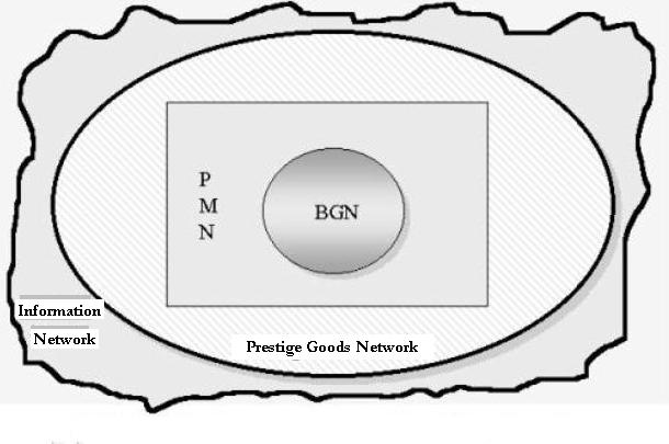
particular locale:
Information
Networks (INs)
Prestige
Goods Networks (PGNs)
Political/Military
Networks (PMNs) and
Bulk
Goods Networks (BGNs).
The largest networks are those in which information and
ideas travel. Information is light and it travels a long way, even in systems
based on down-the-line interaction.[4]
These are termed Information Networks (INs).
A usually somewhat smaller interaction network is based on the exchange of
prestige goods or luxuries that have a high value/weight ratio. Such goods
travel far, even in down-the-line systems. These are called Prestige Goods
Networks (PGNs). The next
largest interaction net is composed of polities that are allying or making war
with one another. These are called Political/Military Networks (PMNs). [5]And
the smallest networks are those based on a division of labor in the production
of basic everyday necessities such a food and raw materials. These are Bulk
Goods Networks (BGNs). Figure 1
illustrates how these interaction networks are spatially related in most
world-systems.
World-systems
vary in the degree to which these different kinds of interaction are systemic –
have important impacts on local sociocultural reproduction and social change.
In all systems the Bulk Goods Network (BGN) and the Political-Military Network
(PMN) are systemic. But the Prestige Goods Network varies across systems in
both the ways it may be systemic and the extent to which it is important for
sociocultural reproduction and social change. And the same may be said of the
Information Network (IN).
Immanuel Wallerstein (1974) defined
core/periphery relations in the modern world-system in terms of a hierarchical division of labor
in the production of necessities between different polities or regions. This is
the BGN. In world-system comparative perspective the BGN may or may not be
hierarchical in the sense of unequal exchange in different systems, but it is
always systemic because it is important for reproducing local households and
communities. Political-military interactions among polities (alliances and
warfare) may or may not correspond spatially with the Bulk Goods Network,
though the assumption that polities do not trade or intermarry with their
traditional enemies is often false.
Anthropologists have long noticed
the importance of prestige goods when they are used by elites to reward
subalterns and to control marriage (Sahlins 1972 ; Eckholm and Friedman
1982 ; Peregrine 1992 ) And
Jane Schneider (1991 ) claimed that, contra
Wallerstein, prestige goods flows across the Silk Roads had played an important
role in the development of the core regions of Eurasia as well. Mary Helms (1988) has emphasized the
importance of exotic ideas as well as goods in the emergence of theocratic
chiefdoms and early states. A study of a
very small world-system in
Figure
1: Nested Interaction Networks
The first question for any locale concerns the nature and spatial
characteristics of its links with the above four interaction nets. This is
prior to any consideration of core/periphery relation because one region must
be linked to another by systemic interaction in order for a consideration of
whether or not interpolity relations involve exploitation or domination is
relevant. The spatial characteristics of these networks clearly depend on the
costs of transportation and communications, and whether or not interaction is
only with neighbors or there are regularized long-distance trade journeys being
made. But these factors affect all kinds of interaction and so the relative
size of networks is expected to approximate what is shown in Figure 1. Fall-off
in the PMN generally occurs
after two or three indirect links. Suppose polity X is fighting and allying
with its immediate neighbors and sometimes with the immediate neighbors of its
neighbors. So its direct links extend to the neighbors of the neighbors. But
how many indirect links will involve actions that will importantly affect this
original polity? The number of indirect links that bound a PMN is usually either two or three. As
polities get larger and interactions occur over greater distances, each
indirect link extends much farther across space. But the point of important
fall-off will usually be after either two or three indirect links.
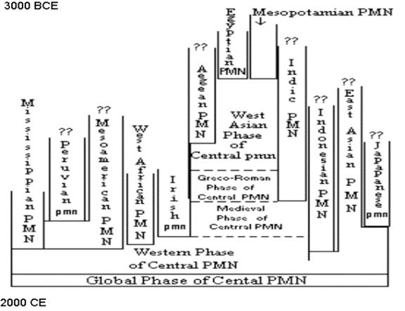
Figure
2: Chronograph of the Emergence of the
Using this conceptual apparatus, we
can construct spatio-temporal chronographs for how
the social structures and interaction networks of human populations changed
their spatial scales to eventuate in the single global political economy of
today. Figure 2 uses PMNs
as the unit of analysis to show how what David Wilkinson (1987) calls “Central
Civilization,” a PMN that was formed when
the Mesopotamian and Egyptian PMNs
merged in about 1500 BCE and which eventually incorporated all the other PMNs into itself to become the
contemporary global interstate system. The timing of mergers and expansions
depicted in Figure 2 are based on Wilkinson’s careful reading of world history
to determine when the regions specified began to make war and alliances with
one another. This kind of chronograph could be constructed for other regions
using the same kinds of historical evidence, and this would be a huge
contribution to our knowledge of the expansion of socio-cultural systems.
World-System Cycles: Rise-and-Fall
and Oscillations
Comparative
research reveals that all world-systems exhibit cyclical processes of change.
There are two major cyclical phenomena: the rise and fall of large polities,
and oscillations in the spatial extent and intensity of trade networks. “Rise
and fall” corresponds to changes in the centralization of political/military
power in a set of polities. It is a question of the
relative size and distribution of power across a set of interacting polities.
All world-systems in which there are
hierarchical polities experience a cycle in which relatively larger polities
grow in power and size and then decline. This applies to interchiefdom
systems as well as interstate systems, to systems composed of empires, and to
the modern rise and fall of hegemonic core powers (e.g.,
Chase-Dunn and Hall (1997) contend
that the causal processes of rise and fall differ to some extent depending on
the predominant mode of accumulation. One big difference between the rise and
fall of empires and the rise and fall of modern hegemons is in the degree of
centralization achieved within the core. Tributary systems alternate back and
forth between a structure of multiple and competing core states on the one
hand, and core-wide (or nearly core-wide) empires on the other.[6]
The modern interstate system experiences the rise and fall of hegemons, but
these never take over the other core states to form a core-wide empire. This is
because the modern hegemons have pursued a capitalist, rather than a tributary,
form of accumulation.
Analogously, rise and fall works
somewhat differently in interchiefdom systems because
the institutions that facilitate the extraction of resources from distant
groups are not as developed in chiefdom systems. David G. Anderson’s (1994)
study of the rise and fall of Mississippian chiefdoms in the Savannah River
valley provides an excellent and comprehensive review of the anthropological
literature about what
Chiefs relied more on hierarchical
kinship relations, control of ritual hierarchies, and control of prestige goods
imports than did the rulers of true states. These chiefly techniques of power
are all highly dependent on normative integration and ideological consensus.
States developed specialized organizations for extracting resources that
chiefdoms lacked—standing armies and bureaucracies. And states and empires in
the tributary world-systems were more dependent on the projection of armed
force over great distances than modern hegemonic core states have been. The
development of commodity production and mechanisms of financial control, as
well as further development of bureaucratic techniques of power, have allowed
modern hegemons to extract resources from far-away places with much less
overhead cost.
The development of techniques of
power has made core/periphery relations ever more important for competition
among core powers and has altered the way in which the rise-and-fall process
works in other respects. Chase-Dunn and Hall (1997, Chapter. 6) argue that
population growth, degradation of natural resources, and changes in productive
technology and social structure, have generated sociocultural development that
is marked by cycles and occasional upsweeps. This is because any world-system
varies around an equilibrium as a result of both internal instabilities and environmental
fluctuations. Occasionally, on one of the upswings, a system solves its
problems in a new way that allows for substantial expansion. The point is to
explain expansions, qualitative transformations of systemic logics, and
collapses by studying whole world-systems over time and by comparing these to
one another.
The multiscalar
regional method of bounding world-systems as nested interaction networks
outlined above is complimentary with a multiscalar
temporal analysis of the kind suggested by Fernand Braudel’s
work. Temporal depth, the longue durée, needs
to be combined with analyses of short-run and middle-run processes to fully
understand social change.
The diagram in Figure 3 depicts the
coming together of the East Asian and the West Asian/Mediterranean systems.
Both the PGNs and the PMNs are shown, as are the oscillations
and rise and fall sequences. The larger PGNs
linked intermittently and then joined. The PMNs
were joined briefly by the Mongol conquerors, and then more permanently when
the Europeans and Americans established Asian treaty ports. The pink area of
Figure 3 depicts the same
It should be noted that the
depiction in Figure 3 of the spatial boundaries of the PMNs and the PGNs is
only an approximation. Another rough depiction of expanding, contracting and
eventually merging is contained in Chase-Dunn and Hall’s (1998) study of
world-systems in
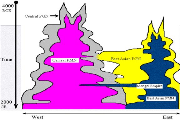
Figure
3: The Eastern and Western PMNs and PGNs
The SetPol Project
The SetPol project is constructing a
multidisciplinary theoretical research program to test hypotheses about the
causes of changes in city and empire sizes from the second millennium BCE to
the present in order to shed light on the contemporary and near future global
situation. The project is inventorying
explanations of scale changes from anthropology, sociology and political
science and is developing and populating templates for a graph database that
will allow the use of geographical and
network analyses for studying interactions among cities and empires. This
database structure makes it possible to test causal propositions and models
derived from the comparative evolutionary world-systems perspective,
geopolitics and human ecology -- theoretical perspectives that have been
developed by sociologists, anthropologists and political scientists—and constructs
a multidisciplinary sociohistorical theoretical research program. The
quantitative graph database includes the territorial sizes of states and
empires (polities), the population sizes of cities and polities, interaction
links and climate change in ten world regions over the past 3500 years. The
project also spatially bounds whole interaction networks by estimating changes
in the boundaries and intensities of human interactions of several kinds:
everyday necessities, the trade of high value goods, the interactions of
fighting and allying polities and the diffusion of ideas and genetic materials.
SetPol codes the power configurations (unipolar,
bipolar, multipolar, etc.) of interstate systems and the world-system positions
of settlements and polities (core, semiperiphery and periphery) within regional
interaction networks. Causal propositions will be tested using five different
units of analysis: individual cities and polities, networks of interacting
cities and polities and spatially constant regions and the whole Earth as a
single context for studying the causes of changes in urban and polity scales. A
research team from archaeology, anthropology, geography, history, political
science, sociology, ecology and climatology will carry out this first two-year
phase. The multidisciplinary theoretical research program that will be
developed will come primarily from anthropology, sociology, political science
and geography, but participation by climatologists, historians, computer
scientists and ecologists will contribute to the production of an improved
database that allows for the use of geographical and network research
methods.
The
long-standing upward trends in the sizes of cities and polities is well known,
but still in dispute are the long-term, proximate and contextual causes of
these trends. The SetPol project improves upon and
extends existing quantitative compilations of estimates of the sizes of cities
and polities to identify those instances in ten world regions in which upsweeps
in polity and city sizes have occurred, and will empirically examine the human
and natural factors that have been hypothesized to be the causes of these
instances of scale change. The project also identifies instances of collapse in
the sizes of polities and cities and studies their causes. The project also develops
accurate approximations of the growth and intensity of interaction networks
that have constituted economic and political globalization since the late
Bronze Age. The project employs both standard comparative methods and recently
developed geographical and network approaches to data analysis that use both
GIS spatial analysis and formal network methods. This contributes to the
scientific understanding of the causes of the emergence of complexity and
hierarchy in human societies and deepens our understanding of sociocultural
evolutionary processes.
The SetPol project uses
both quantitative estimates of population sizes of the largest cities in world
regions and estimates of the territorial sizes of largest states and empires to
study the causes of changes in the scale of human institutions. Upsweeps are
instances in which the largest settlement or polity in a region significantly
increases in size for the first time. The project also uses spatially constant
world regions as well as spatially changing whole interaction networks
(world-systems) as units of analysis. This multidisciplinary research is
organized around the territorial sizes of polities and the population sizes of
cities because these are relatively easily ascertainable quantitative
indicators of system size and complexity. Interval scale metrics are needed in
order to tell the difference between small and large changes in scale. When human sociocultural systems are studied
over long periods of time cyclical processes of population growth and decline,
the rise and fall of large and strong polities, are empirically evident. This
project will employ a systematic method[8] of
differentiating between a “normal” upswing or downswing in which the scale of
sociocultural organization is fluctuating around an equilibrium level and an
event of growth or decline that is significantly greater than the normal
fluctuations (see Figure 4). Focusing on
the largest cities and polities in each region rather than on individual cities
or polities makes these cycles of upswings, downswings, upsweeps and collapses
visible. Are the forces and conditions
that cause upsweeps simply larger than those that cause upswings, or are
different factors involved? Or do they combine in different ways? And are the
causes of upsweeps the same as the causes of collapses but in reverse? The
project uses upswings, upsweeps, downswings, downsweeps
and collapses of city and polity sizes as dependent variables to be explained.
This project studies city and polity sizes in ten world regions from 1500 BCE
until 2010 CE.
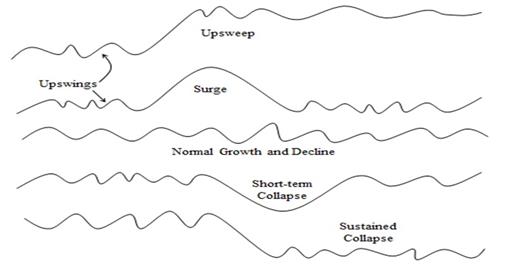
Figure 4: Types of Medium-term Scale Change in the
Largest Cities and Polities
SetPol builds on and improves earlier data compendia and uses
the upgraded data to more accurately identify upsweep and collapse events
(Inoue et al 2012 and Inoue et al 2015). An example of results obtained using the
territorial sizes of the largest polities in Europe and East Asia is shown in
Figure 5.
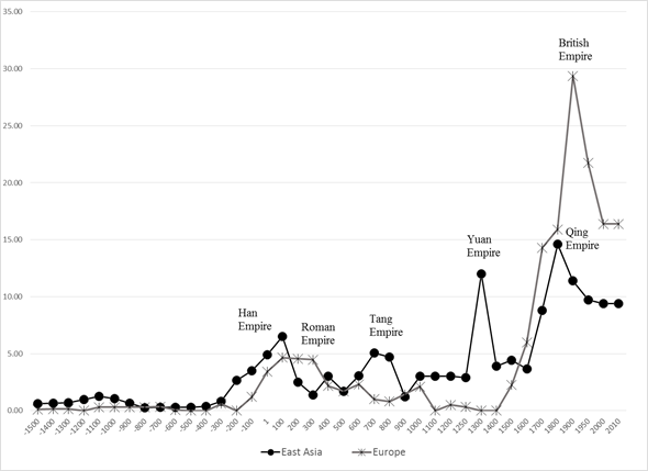
Figure 5: Sizes of
largest polities in Europe and East Asia (square megameters): 1500 BCE- 2010CE
Figure 5 shows the
sizes of the largest states and empires in Europe and East Asia since 1500 BCE.
Both regions show the overall long-term trend toward greater polity sizes and
also the sequences of shorter-term fluctuations. When we look at Europe’s
trajectory vis a vis East Asia in Figure 2 we can see that the rise of
the Han Empire in China began earlier than the rise of the large Macedonian and
Roman empires in Europe and the decline began earlier in East Asia than it did
in Europe. China did it first, followed not long after by Europe. The European
peak then last rather longer than did the Chinese peak. This was what many have
observed as the unusually long tenure of the Roman Empire. Then Europe went
into a long slump while Tang China recovered. So these waves of empire
formation were partly, but not entirely, synchronous, and Walter Scheidel’s (2009) idea of the first great divergence[9] is
supported. But the apparent divergence was partly due to the earlier start of
East Asia. The later rise of Europe began in the 15th century,
contrary to Andre Gunder Frank’s (1998,2014)
contention that the great divergence that was the rise of Europe was a late and
conjunctural event. Qing China also got very large
but ended up only half as large, in terms of territorial size, as the British
Empire.
The main
multidisciplinary theoretical thrust of SetPol is
based on a scope of comparison that comes from anthropology, archaeology and
world history. This scope is combined with competing explanations of scale
changes that come from ecology, sociology, history and political science,
especially international relations theory.
Sociology gave birth to the world-system perspective (Wallerstein 1974),
which posits the existence of a hierarchical Europe-centered interstate system
that emerged in the long sixteenth century CE[10] in
which some polities (those in the core) exploit and dominate others (the
semiperiphery and the periphery). SETPOL
will utilize an anthropological and world historical framework to compare
small, regional and global world-systems over the past 3500 years (Chase-Dunn
and Hall 1997; Chase-Dunn and Lerro 2014). .
Political scientists focus on political
institutions and on international relations, especially regarding power
dynamics among competing states, institutions of diplomacy and arms races.
International relations theory focuses on geopolitics as a struggle for power
in which military capabilities and warfare are central components. Geopolitics
is most often understood as a multiplayer game in which territorial strategies
are an important element, in means and ends, of power struggles. Most
international relations theorists focus on the interstate system that emerged
in Europe after being institutionally defined by the treaty of Westphalia in
1648 CE. SETPOL uses an anthropological and world historical framework to
examine the nature of interstate systems since the emergence of early states in
Mesopotamia and Egypt.
Chase-Dunn and Hall
(1997) contended that world-systems, defined as interaction networks with
consequential effects for local social structures, are the most important unit
of analysis for explaining large-scale social change. The evolutionary[11]
world-systems perspective allows comparisons between whole interaction networks
that are different in size, period and location. They point out that different kinds of
interaction have distinct spatial characteristics and degrees of importance in
different kinds of world-systems. Chase-Dunn and Hall (1997) employ a
place-centric approach that bounds spatial networks by asking what reproduces
or changes the social structures of a designated locality. Always important are
low value per unit of weight food and other everyday raw materials (bulk goods)
that form a network that is usually spatially smaller than the network of
political/military interaction. And there are even larger networks formed by
exchanges of information and prestige goods that may be consequential for local
social structures. Chase-Dunn and Hall (1997) also turn the issue of
core/periphery hierarchies into an empirical question rather than a
definitional assumption. The evolutionary comparative world-systems approach
allows for the possibility that world-systems might exist that do not have
core/periphery hierarchies, and indeed the small-scale system in indigenous
Northern California studied by Chase-Dunn and Mann (1998) had very limited
interpolity domination and exploitation. Core/periphery hierarchies emerge and
evolve, along with other types of inequality, as the capabilities of some
polities to extract resources from distant peoples develop.
Most state-based
world-systems are organized as hierarchical interstate systems in which core
polities and cities exploit and dominate non-core peoples. Power is organized in
different ways in different systems and so what semiperipherality
is in any system depends on what coreness and peripherality are. These are relational concepts. But it is
possible to identify these world-system positions in very different kinds of
systems based on common characteristics that are associated with them such as
population density, geographical location, and differences in modes of
accumulation (foraging, pastoralism, horticulture, agriculture, scale of
irrigation, industrialization). Chase-Dunn and Hall (1997) describe a
phenomenon they call “semiperipheral development.” This involves the observation that peoples
and polities that are semiperipheral vis a vis the larger world-system
of which they are a part are more likely to implement technological and
organizational forms that facilitate upward mobility and/or that change the
developmental logic of world-systems.
One variety of this phenomenon involves semiperipheral marcher
states that conquer older core regions to produce an upsweep in polity size.
Another variety involves semiperipheral capitalist city-states that are agents
of commodification—the expansion and deepening of trade networks. Increasing
trade and production for exchange facilitates provides a fertile context for
the emergence of larger cities and larger polities.
There are several possible processes that might
account for the phenomenon of semiperipheral development.
Randall Collins (1999) has argued that the phenomenon of marcher states
conquering other states to make larger empires is due to the “marcher state
advantage.” Being out on the edge of a core region of competing states allows
more maneuverability because it is not necessary to defend the rear. This
geopolitical advantage allows military resources to be concentrated on
vulnerable neighbors. Peter Turchin (2003) has argued
that the relevant process is one in which group solidarity is enhanced by being
on a “metaethnic frontier” in which the clash of
contending cultures produces strong cohesion and cooperation within a frontier
polity, allowing it to perform great feats. Carroll Quigley (1961) distilled a
somewhat similar theory from the works of Arnold Toynbee. Another factor
affecting within-group solidarity is the different degrees of internal
stratification usually found in premodern systems between the core and the
semiperiphery. Core societies develop old, crusty and bloated elites who rely
on mercenaries and “foreigners” as subalterns, while semiperipheral leaders are
often charismatic individuals who identify with their soldiers and citizens
(and vice versa). Less inequality within a polity often means greater group
solidarity and this may be an important part of the semiperipheral advantage.
Ibn Khaldun’s (1958) model of nomadic barbarians
conquering decrepit old civilizations has been an inspiration to some of this
thinking. And the tie with internal inequality may also be linked with waves of
population growth and unrest within polities – the so-called “secular cycle”
(Goldstone 1991; Turchin and Nefadov
2009).
Hub theories of innovation have been popular among
world historians (e.g. McNeill and McNeill 2003; Christian 2004) and human
ecologists (Hawley 1950). These hold that new ideas and institutions emerge in
central settlements where information crossroads are located. Mixing and
recombination of ideas and information leads to the emergence of new
formulations. Recent studies have shown
evidence that information exchange, innovations, and political, economic and
social activities increase exponentially with city size (Ortman
et al. 2014; Ortman et al. 2015).
Esther Boserup
(1965) developed a demographic theory that focuses on population growth and
population pressure as the master variables behind social change. Technological
change was explained as an adaptation to population density nearing or
exceeding the carrying capacity of the environment under a given technological
regime. Cultural ecology and population pressure have important implications
for sociocultural development when they are combined with the idea of social
and ecological circumscription proposed by Robert Carneiro
(1978). Carneiro explained the social organizational
ruptures that produced the first states in terms of population pressure in a
geographic situation in which outmigration was impossible or very costly. Under
these conditions people stay and fight rather than migrating. High levels of
warfare killed off population and reduced population pressures. Some systems
got caught in a vicious cycle in which warfare operated as a demographic
regulator (e.g. Kirch 1991). But in other systems
people became tired of warfare and allowed the emergence of elites who
organized larger polities that regulated conflict and resource allocation
(property). The elements of population pressure, intensification of production,
ecological degradation, technological change, conflict, and circumscription are
combined in different ways by different theorists, but these are the main
ingredients that comprise most of the explanations of long run cultural evolution
by archaeologists and many anthropologists (e.g., Johnson and Earle 1987; see
also Chase-Dunn and Hall 1997: Chapter 6).
SetPol’s main dependent variables are changes in the scale of polities and
cities. Individual polities and cities will be studied, and the sizes of the
largest of these within regions and interaction networks will be studied as characteristics
of the region or the network.[12]
As mentioned above this project will divide the indicators of scale change into
upswings, upsweeps, downswings, downsweeps, surges
and collapses (Inoue et al 2012). Though these are all based on the
sizes of largest cities and polities, timing and the way in which the unit of
analysis is employed (regions vs different kinds of networks) will affect the
identification of these scale changes. The main independent variables that will
be studied are: the world-system positions of polities and cities
(core-semiperiphery-periphery), the power configurations of interstate systems
(unipolar, bipolar, multipolar, etc.) (Wilkinson 2003), changes in the
intensity of warfare, network node centrality, the centralization of whole
networks (graph centrality); climate change, and environmental degradation. The
project will also examine the extent to which changes in the sizes of cities
are associated with changes in the sizes polities. In addition to focusing on
the largest cities or polities in each region or network, the project will also
compute and study the size distributions of largest cities and polities. Urban
geographers have long theorized about the causes and consequences of city size
distributions.[13] Our
comparison of largest polities in East Asia, Europe and the Central
Political/Military Network[14] enable us to ascertain how the size
distributions have changed over time and how these may be related with scale
changes and possible inter-regional synchronies.
The SetPol theoretical research program is developing and
testing an integrated synthetic model of the long-term causes of human
sociocultural evolution – specifically the growth of cities and polities, but
also increasing structural complexity and hierarchy in human polities and
world-systems. The integrated model combines the iteration model produced by
Chase-Dunn and Hall (1997: Chapter 6; Chase-Dunn and Lerro
2014: Figure 2.5 on page 27) with the structural demographic model developed by
Jack Goldstone (1991) and elaborated and formalized by Peter Turchin and Sergey Nefadov
(2009). This multilevel model includes processes that operate within
settlements and polities, especially demographic growth, population pressure,
growing inequalities, social movements and state failure, with processes that
operate between polities (warfare, interpolity trade, semiperipheral
development, etc.) and climate change and epidemic diseases.
The Comparative Framework
SetPol studies expanding and contracting
interaction networks among human polities and settlements as both units of
analysis and as causal contexts of scale changes in the sizes of cities and
empires. Human interaction networks have expanded and intensified over the long
run (globalization), but in the medium-run there have been cycles of network
expansion and contraction.
The best way to spatially bound human social
systems is an old question that continues to generate heated disputes among
social scientists. Michael Mann (1986) notes that different important kinds of
interaction have different spatial scales, and so the notion that societies
have single spatial boundaries is usually incorrect and causes much misunderstanding.
Many regionalists define regions in terms of homogenous attributes, either
natural or social. Comparative civilizationists have tended to focus on the core cultural
characteristics that are embodied in religions or world-views and have
constructed lists of such culturally defined civilizations that then become the
“cases” for the study of social change (e.g. Melko
and Leighton 1987). Another approach that defines regions as areas with
homogenous characteristics is the “culture area” approach developed by Alfred
L. Kroeber and his colleagues (e.g. Wissler 1927; Kroeber 1944). This project
gathered valuable information on all sorts of cultural attributes such as
languages, architectural styles, technologies of production, and kinship
structures, and used these to designate bounded and adjacent “culture areas”
that have been widely used to organize studies of indigenous peoples (e.g.
Sturtevant 1978-2007, the Smithsonian Handbook of North American Indians).
As we mentioned above, a major problem with both
the civilizationist and the cultural area traditions
is the assumption that homogeneity is a good approach to bounding whole social
systems. Heterogeneity rather than homogeneity has long been an important
aspect of human social systems because different kinds of groups often
complement one another and interaction often produces co-evolution and
differentiation.[15] The effort to bound
systems as homogeneous regions obscures this important fact. Spatial
distributions of homogeneous characteristics do not bound separate social systems.
Indeed, social heterogeneity is often produced by interaction, as in the cases
of core/periphery differentiation, urban/rural, and sedentary/nomadic systems.
Even sophisticated approaches that examine distributions of spatial
characteristics statistically must make quite arbitrary choices in order to
specify regional boundaries (Burton, Moore, Whiting and Romney 1996).
David Wilkinson (2003) has made a strong case for
studying civilizations as networks of allying and fighting polities and he has
produced a chronograph of the expansion of the interstate system that emerged
when the Mesopotamian and Egyptian systems became linked around 1500 BCE
(Wilkinson 1987). Many world-systems scholars have contended that trade
networks are the best unit of analysis for spatially bounding whole systems
(Abu-Lughod 1989; Beaujard
2005, 2010). Immanuel Wallerstein (1995; 2011 [1974]) contends that a
hierarchical core/periphery division of labor, especially the one that emerged
with Europe as its core in the long 16th century CE, is the best way
to spatially bound a world-system. And several eminent scholars have claimed
that there has been a single global (Earth-wide) system for millennia (Lenski 2005; Frank and Gills 1994; Modelski
2003; Modelski, Devezas and
Thompson 2008, and Chew 2001, 2007). The SetPol
project operationalizes all these units of analysis and pits them against one
another regarding their relevance for explaining scale changes of polities and
cities. We also have convened a workshop to more completely and accurately
specify the changes in trade and PMN network boundaries since 1500 BCE
(Chase-Dunn et al 2015a). And we also use constant regions to make
comparisons so that it is possible to compare the results with what we find
when we use spatially-bounded networks.
.
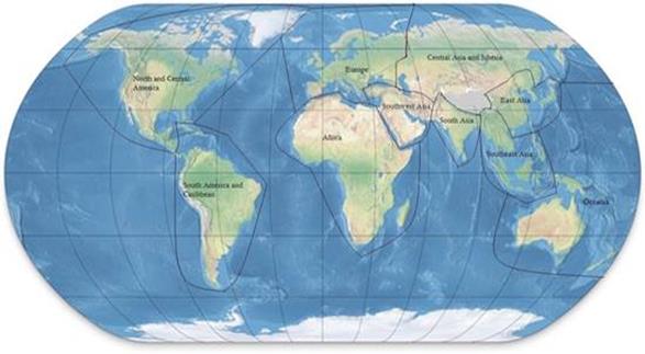
Figure 6: Ten world regions for studying the
emergence of large cities and polities
These boundaries have been chosen in order to
facilitate the comparative study of the emergence of largest cities and polities
over the past 3500 years. The regional
boundaries shown are mainly matters of convenience. All cities and polities are
geocoded so that different regional configurations can easily be used by other
researchers. These regions have been chosen in order to construct a data compendium
that will include information on all the areas of the Earth where humans have
lived in large numbers. The regions specified in Figure 6 are mainly based on
our knowledge of where large cities and empires emerged in the period we are
studying. But we have also considered the social science literature that has
hypothesized comparisons and connections among regions in our designation of
regions. We are well aware of the issue of Eurocentrism in social science and
the obvious point that “Europe” is not a continent, but is rather a promontory
of Eurasia (Lewis and Wigen 1997). Social science
itself has been constructed around comparisons between East and West and so an
important way to scientifically address the issues of comparison and
connections is to use some of the categories that have been constructed in the
past to see whether alleged differences (or similarities) are supported or
contradicted by quantitative data.
Admittedly some of
the bounding decisions we have made are somewhat arbitrary. We included the
Caribbean with South America rather than with North and Central America because
migrants from South America mainly peopled it. We made a great effort to have
only ten world regions rather than some larger number of regions in order to
keep our data gathering structure from becoming too complicated. But it should
be recalled that all of the settlements and polities we study are geocoded, so
if other researchers want to reconfigure regions in a different way they easily
can.
Using world regions designated in this way allows
us to address the important issues raised by world historians and civilizationists who compare regions (e.g. Pomeranz 2000; Scheidel 2009,
Wong 1997; Morris 2010, Frank 1998). The SetPol project
is also be able to compare the use of these spatially constant regions with
what we find when we use expanding networks (e.g. Chase-Dunn et al
2015b). The proposed operationalization of network boundaries is based on a
propositional inventory of statements by social scientists about when smaller
networks expanded, merged and when larger networks engulfed smaller ones (e.g. Beaujard 2005; 2010; Wilkinson 1992a; 1992b, 1993). The
project uses data on trade networks, historical accounts of warfare and
diplomacy and studies of the diffusion of plants, animals, and technologies and
ideas to evaluate the claims made by scholars about interaction networks and
the timing of their expansions.
Chronological
Issues
For purposes of comparing the timing of changes in
city and polity sizes across different world regions it is important to have
accurate absolute chronologies for the regions being compared in order to
examine issues of priority and synchrony. Unfortunately there is still
considerable disagreement about the absolute dating for Mesopotamia before 1500
BCE. Mario Liverani (2014: 9-16) explains why
estimates of absolute dates are so uncertain. Relative dates of events needed
for estimating polity and city sizes are based on “king lists.” Thus an event,
such as a conquest, is said to have occurred in the third year of the reign of
King X. Considerable effort has been made to figure out the correspondences
between different kings’ lists in Mesopotamia and their correspondence with
Egyptian king lists, which are more continuous. These are then converted in to
calendar years by ascertaining their relationships with astronomical events
such as eclipses. Unfortunately there is a period after the fall of the
Babylonian empire in which king lists are missing for Mesopotamia, and there is
disagreement about the timing of astronomical events. Thus the length in years
of the occluded period is in dispute, and this results in so-called, short,
medium and long chronologies for the period before the Late Bronze Age, with an
error of as much as 100 years. Absolute dating is needed in order to compare
the timing of scale changes across world regions. It matters whether or
not the city of Ur was sacked in 2004 BCE, and thus is eliminated from the list
of large cities and large polities in 2000 BCE, or in some other year 50 years
earlier or later. Liverani (2014: 15) is satisfied to
use the middle chronology for Mesopotamia and the surrounding regions, but he
is not trying to compare the timing of changes in the Ancient Near East with
other world regions. The SetPol project uses the
middle chronology, while being careful to determine which chronology has been
used in the sources from which estimates are coded. It is important to be chary
regarding temporal comparisons among regions before 1500 BCE.
The
SetPol goal is to achieve a minimum temporal
resolution of every twenty-five years because the project is studying
middle-run growth/decline phases of polities and cities. Archaeological
evidence of the areal sizes of settlements and hearth counts can be used to
estimate settlement sizes, but the limitation here is often temporal
resolution. Studies that rely on radiocarbon dating and archaeological phase
periodization often do not achieve a level of temporal resolution that would
make settlement growth/decline phases visible (e.g. Ortman,
Cabaniss, Sturm and Bettancourt
2014). When temporal resolution is poorer than every 100 years it is likely
that some of the cycles of growth and decline will be missed. In the first phase of our project we will
focus on regions for which both documentary and archaeological evidence are
available, and since this phase begins with 1500 BCE we do not need to worry
about the issue of absolute dates when comparing world regions.
Data Upgrading[16]
Improving of estimates of the population sizes of settlements and the
territorial sizes of polities is an endless task, but much has been
accomplished. The long term intent of the SETPOL project is to include all the
towns and cities with 10,0000 or more people and all the polities with .01 or
larger square megameters of territory in the ten
world regions from 4000 BCE to 2010 CE. But in the exploratory phase of the
project (the first two years) the project will prioritize by focusing on
upgrading existing data sets that include the ten largest cities and
polities in each of the world regions at 25-year intervals since 1500
BCE.
Improving estimates of the territorial sizes of polities
Determining
scale shifts requires real metric (interval-level) estimates, not just periodizations of growth and decline. The territorial sizes
of polities are difficult to estimate from archaeological evidence alone (see Smith and Montiel
2001). What the SETPOL project wants to know is
the size of the area over which a central power exercises a degree of
control that allows for the appropriation of important resources (taxes and
tribute). The ability to extract resources falls off with distance from the
center in all polities, and controlling larger and larger territories requires
the invention of new transportation, communications and organizational
technologies [what Michael Mann (1986) has called “techniques of power”].
Military technologies and bureaucracies are important institutional inventions
that make possible the extraction of resources over great distances, but so are
new ideologies and new technologies of communication (Innis 1950).[17]
Estimating
the territorial sizes of states and empires has been based on the use of
published historical atlases and historical accounts. Premodern states and
empires often had fuzzy boundaries. Bounding polities is based primarily on
knowledge about who conquered which city, and whether or not, and for how long,
tribute was paid to the conquering polity. Sometimes it is difficult to tell
whether or not tribute is asymmetrical or symmetrical exchange. Only
asymmetrical (unequal) exchange signifies a tributary imperial relationship.
Otherwise it is just trade and does not signify an extractive relationship.
The pioneer coder of the territorial sizes of
polities is Rein Taagepera (1978a, 1978b, 1979, and
1997). The SETPOL project builds upon Taagepera’s
monumental work and uses his methods. Taagepera used
Atlases and historical descriptions of events to estimate the territorial sizes
of states and empires. This project will improve upon his estimates by using
Atlases that had not been published when Taagepera
did his work (e.g. Schwartzberg (1992). The
project will also use online sources such as the University of Sydney Timemap Project. The values produced from these tertiary
sources will be checked with regional experts (see Data Management section).The
SETPOL polity data template utilizes Taagepera’s
method of coding the year in which polity sizes change, usually as a result of
conquests, and will designate area in square megameters
as Taagepera did.[18] It will
also include a standardized identification code for each separate polity,
fields for alternative names of the polity, geocodes for the location of the
capital city and estimates of the population size of the polity.[19]
Improving estimates of the population sizes of
cities and territorial sizes of states and empires
SETPOL is developing a template for coding characteristics
of individual cities that include estimates of the size of the built up area as
well as estimates of the population size. The city template also includes
unique identifiers for each city, fields for alternative names of the city and
the geocode of the city center. For the
location identification, the geo URI scheme is applied.[20] The data are structured in the three
dimensions—each city has sets of variables, and each of these variables has
varying value ranges and time intervals. The variables and their definitions
are being developed in collaboration with the SESHAT project team in order to
avoid redundancies in collecting data. A template for polities for coding
similar variables is also being constructed.
Making accurate
estimations of the population sizes of both contemporary and early urbanized
areas involves several complicated problems. Daniel Pasciuti
(Pasciuti 2003; Pasciuti
and Chase-Dunn 2003) has proposed a measurement error model for estimating the
sizes of settlements based on the literature in archaeology, demography and
urban geography.[21] The SETPOL project
defines a settlement as a spatially contiguous built-up area.[22] This is
the best operationalization for comparing the sizes of settlements across
different polities and cultures because it ignores the complicated issues of
governance boundaries (e.g. municipal districts, etc).
But it still has some problems. Most cultures have nucleated settlements in
which residential areas surround a monumental, governmental or commercial
center. In such cases it is fairly easy to spatially bound a contiguous built
up area based on the declining spatial density of human constructions. But
other cultures space residences out rather than concentrating them near a
central place (e.g. many of the settlements in the prehistoric American
Southwest such as Chaco Canyon). In such
cases it is necessary to choose a standard radius from the center in order to
make comparisons of population sizes over time or across cultures.
Existing compilations of city sizes rely primarily
on:
1.
Tertius Chandler
1987 Four Thousand Years of Urban Growth: The Edwin Mellen
Press
2.
George Modelski 2003 World
Cities: –3000 to 2000. Washington, DC:
Faros 2000
3.
Ian Morris
2013 The Measure of Civilization. Princeton, NJ: Princeton University
Press.
Tertius Chandler’s
(1987) compendium is still the most comprehensive study of large cities, but
substantial improvements were made in George Modelski’s
(2003) compendium. Ian Morris also provides estimates of the largest cities in
his book on measuring the development of Eastern and Western civilizations
(Morris 2013). The SETPOL project will improve upon existing city size
compilations by collaborating with other projects and incorporating data sets
produced by others.[23]
Our city template includes both the calendar year in which the size of a city
is known to have rapidly changed (e.g. the example of the sack of Ur mentioned
above) as well as interpolated estimates for the standardized years used by
Chandler and Modelski.[24]
REFERENCES
Abu-Lughod, Janet. 1989. Before European Hegemony: The World
System A.D. 1250-1350. New York: Oxford University Press.
Adams, Robert
McCormick. 1981. The Heartland
of Cities: Surveys of Ancient Settlement and Land Use on the Central Floodplain
of the Euphrates. Chicago: University of Chicago Press
Alexandria
Digital Library (ADL) Gazetteer http://www.dlib.org/dlib/january99/hill/01hill.html
Algaze, Guillermo. 1993. The Uruk
World System: The Dynamics of Expansion of Early Mesopotamian Civilization.
Chicago: University of Chicago Press.
Al Khalifa,
Shaikha Haya Alia and Michael Rice (eds.) Bahrain Through
the Ages. London: KPI
Allen,
Mitchell. 1995. Contested Peripheries: Philistia in the Neo-Assyrian
World-System. Unpublished Ph.D. Dissertation, UCLA.
_____.
2005. “Power is in the Details: Administrative Technology
and the Growth of Ancient Near Eastern Cores.” Pp. 75-91 in The Historical Evolution of World-Systems,
edited by Christopher Chase-Dunn
and E. N. Anderson.
Anderson,
Eugene. N. 2014. Food and
Environment in Early and Medieval China. Philadelphia, PA:
University
of Pennsylvania Press.
Anderson, Eugene. N. and C. Chase-Dunn. 2005“The
Rise and Fall of Great Powers” in Christopher
Chase-Dunn and E.N. Anderson (eds.) The
Historical Evolution of World-Systems. London:
Palgrave.
Anderson, David G. 1994 The
Arrighi,
Giovanni. 1994. The Long Twentieth Century: Money, Power and the Origins of
Our
Times.
Bairoch, Paul. 1988. Cities
and Economic Development Chicago: University of Chicago Press.
Barfield, Thomas J. 1989. The
Perilous Frontier: Nomadic Empires and
Blackwell.
Beaujard, Philippe. 2005 The Indian Ocean in Eurasian and
African World-Systems Before the Sixteenth Century. Journal of World History
16,4:411-465.
_____. 2009 Les mondes
de l’océan Indien Tome
I: De la formation de l’État au premier système-monde Afro-Eurasien (4e millénaire av. J.-C. – 6e siècle apr.
J.-C.). Paris: Armand Colin.
_____. 2010. “From Three possible Iron-Age
World-Systems to a Single Afro Eurasian World-System.” Journal of World
History 21:1(March):1-43.
_____. 2012. Les
mondes de l’océan Indien Tome II: L’océan Indien, au coeur des globalisations de l’ancien Monde du 7e au 15e siècle. Paris: Armand Colin
Bibby, Geofrey
1969 Looking For Dilmun.
Boles, Elson
E. 2012. “Assessing the debate between
Abu-Lughod and Wallerstein over the
thirteenth-century origins of the modern world-syste”・Pp. 21-29 in S. J. Babones
and C. Chase-Dunn (eds.) Routledge Handbook of World-Systems Analysis.
New York: Routledge.
Borgatti, S. P., Everett, M. G. and
Freeman, L. C. 2002 UCINET 6 for Windows: Software for Social
Network Analysis http://www.analytictech.com.
Brohan, P., R. Allan, E. Freeman, D. Wheeler, C.
Wilkinson, and F. Williamson. 2012. "Constraining the temperature history
of the past millennium using early instrumental observations" Clim. Past, 8, 1551-1563.
www.clim-past.net/8/1551/2012/
Burton, M.L,
C.C. Moore, J.W.M. Whiting, and A.K. Romney. 1996. "Regions based on
Social Structure." Current Anthropology 37:87-123.
Carneiro, Robert L. 1978 “Political expansion as an
expression of the principle of competitive exclusion,” pp. 205-223 in Ronald
Cohen and Elman R. Service (eds.) Origins of the State: The Anthropology of
Political Evolution. Philadelphia: Institute for the Study of Human Issues.
_____. 2004. “The
political unification of the world: whether, when and how – some speculations.”
Cross-Cultural Research 38 (2):162-177.
Chandler, Tertius. 1987. Four Thousand Years of Urban Growth: An
Historical Census. Lewiston,N.Y.: Edwin Mellon
Press.
Chase-Dunn, Christopher.
1988 "Comparing World Systems: Toward a Theory of Semiperipheral Development." Comparative
Civilizations Review 19(Fall):29-66.
__________ 1990
"Resistance to Imperialism:
Semiperipheral Actors." Review 13:1(Winter):1-31.
Chase-Dunn, Christopher and E.N.
Anderson (eds.) 2005. The Historical Evolution of World-Systems.
____________
and Kelly M. Mann. 1998 The
Wintu and Their Neighbors:
A Small World-System in Northern California, University of
________________
and Thomas D. Hall 2006 “Ecological
degradation and the evolution of world-systems”
Pp. 231-252 in Andrew Jorgenson and Edward Kick (eds.)
Globalization and the
Environment.
Chase-Dunn, Christopher and Susan
Manning, 2002 "City systems and world-systems: four millennia of city growth and decline," Cross-Cultural Research 36, 4:
379-398 (November).
Chase-Dunn, C., Susan
Manning, and Thomas D. Hall, 2000 "Rise and Fall: East-West Synchronicity and Indic
Exceptionalism Reexamined" Social
Science History 24,4: 721-48(Winter).
____________
Alexis Álvarez, and Daniel Pasciuti
2005 "Power
and Size; urbanization and empire formation in world-systems"
Pp. 92-112 in C. Chase-Dunn and E.N. Anderson (eds.) The Historical
Evolution of World-Systems.
_____________and T.D.
Hall (eds.) 1991 Core/Periphery Relations
in Precapitalist Worlds.
_______________ and Thomas D. Hall 1997 Rise
and Demise: Comparing World-Systems.
____________________and Thomas D. Hall, 1998
"World-Systems in North America: Networks, Rise and Fall and Pulsations of
Trade in Stateless Systems," American Indian Culture
and
Research Journal 22,1:23-72.
Chase-Dunn, Christopher, Daniel Pasciuti,
Alexis Alvarez and Thomas D. Hall 2006
“Waves of globalization and
semiperipheral development in the ancient Mesopotamian and Egyptian world-systems. Pp. 114-138 in Globalization and Global History edited
by Barry K. Gills and William R.
Thompson.
Chase-Dunn, C. and Andrew K. Jorgenson. 2003. “Regions and
Interaction Networks: an institutional materialist perspective.” International Journal of Comparative Sociology
44(1):433-450.
Chase-Dunn, C and Bruce Lerro 2014 Social Change: Globalization from the Stone
Age to the
Present. Boulder, CO:
Paradigm
Chase-Dunn, C. David Wilkinson, E.N. Anderson, Hiroko Inoue
and Robert Denemark 2015a “Time- mapping globalization since the Bronze
Age” IROWS Working Paper
#
100 https://irows.ucr.edu/papers/irows100/irows100.htm
Chase-Dunn, C.
Hiroko Inoue, Alexis Alvarez, Rebecca Alvarez, E. N. Anderson and Teresa Neal 2015 “Uneven Political Development:
Largest Empires in Ten world Regions and the Central International
System since the Late Bronze Age” presented at
the annual conference of the California
Sociological Association, Sacramento, November 13 IROWS Working Paper #85 https://irows.ucr.edu/papers/irows85/irows85.htm
Chew, Sing C.
2001. World ecological degradation: accumulation, urbanization, and deforestation,
3000 B.C.-A.D. Walnut Creek, CA: Altamira Press
_____. 2007. The Recurring Dark Ages:
ecological stress, climate changes, and system transformation
Walnut Creek, CA: Altamira Press
_____. 2014 “The Southeast Asian connection in
the first Eurasian world economy,
200 BC- AD 500” Journal of Globalization Studies,
Vol. 5 No. 1: 82–109
CHGIS: the
China Historical Geographic Information System http://www.fas.harvard.edu/~chgis/index.html
CHIA:
Collaborative for Historical Information and Analysis
http://www.chia.pitt.edu/
Christian,
David. 2004. Maps of Time. Berkeley: University of California
Press.
Cioffi-Revilla, Claudio and David Lai 2001 “Chinese
Warfare and Politics in the Ancient East Asian
International
System, ca. 2700 B.C. to 722 B.C.” International
Interactions 26,4: 1-32.
Colinvaux, Paul 1978 Why Big Fierce Animals Are Rare. Princeton:
_____________
1980 The fates of nations : a biological theory
Collins,
Randall 1981 “Long term social change
and the territorial power of states,” Pp.
71-106 in R. Collins (ed.) Sociology Since Midcentury.
____________
1992. “The Geographical and Economic World-Systems of Kinship-Based and
Agrarian-Coercive Societies.” Review 15(3):373-88.
Collins,
Randall. 1999. Macro-History: Essays in Sociology of the Long Run.
Stanford: Stanford University Press.
Daftlogic n.d. http://www.daftlogic.com/projects-google-maps-area-calculator-tool.htm
Diamond,
Jared. 2005. Collapse. New York: Viking
Eckhardt,
William. 1992. Civilizations, Empires and Wars: A Quantitative History of
War. Jefferson, NC: McFarland.
Ekholm, Kasja and Jonathan
Friedman. 1982. “Capital Imperialism and Exploitation in the Ancient
World-Systems.” Review 6(1):87-110.
Ellis, Erle C., Kees Klein Goldewijk, Stefan
Siebert, Deborah Lightman and Navin
Ramankutty 2010 “Anthropogenic transformation of the
biomes, 1700-2000” Global Ecology
and
Biogeography 19:589-606.
Fagan,
Brian. 2005. The Great Warming: Climate Change and the Rise and Fall of
Civilizations. New York: Bloomsbury
Ferguson, R. Brian, and Neil L. Whitehead, eds. 1992 War in the Tribal Zone: Expanding States and Indigenous Warfare.
Near
East.” Pp. 73-100 in The Domestication and Exploitation of Plants and
Animals, eds. Ucko, P. and G.W. Dimbleby.
Fletcher,
Roland. 1995. The Limits of Settlement Growth. Cambridge: Cambridge University Press.
_____. n.d. City and
Polity Data Files, Personal communication
Frank, Andre Gunder and Barry Gills. 1994. The World System: 500 or
5000 Years? London: Routledge.
Frank, Andre Gunder 1998 Reorient: Global
Economy in the Asian Age. Berkeley: University of
California Press.
_____. 2014 Reorienting the 19th
Century: Global Economy in the Continuing Asian Age. Boulder, CO: Paradigm
Publishers.
Gershenkron,
Alexander 1962 Economic Backwardness in Historical Perspective.
Goldstone, Jack A. 1991 Revolution and Rebellion in the Early Modern
World. Berkeley: University of California Press
_______________ 2009 Why Europe?:
the Rise of the West in World History, 1500-1850. New York:
Mcgraw-Hill
Gotts,
Nicholas M. 2007 “Resilience, panarchy and
world-systems analysis” Ecology and
Society 2,1:24.
Graber,
Robert Bates 2004 “Is a world state just a matter of time?: a
population-pressure
alternative.” Cross-Cultural
Research 38,2:147-161 (May).
Hall, Thomas
D. 1991. Nomadic Peripheries. In Core/Periphery Relations in
Precapitalist
Worlds,
edited by Christopher Chase-Dunn and T.D. Hall.
Hall, Thomas D., Christopher
Chase-Dunn and Richard Niemeyer 2009 “The roles of Central Asian
middlemen
and marcher states in Afroeurasian world-system
synchrony” in Ganesh Trichur
(ed.)
Asian Regionality
in the Twenty-First Century: New
Perspectives on the Modern World-System.
Hall, Thomas D. 2000
"Frontiers, Ethnogenesis, and
World-Systems: Rethinking the
Theories." Pp. 237-270 in A
World-Systems Reader: New Perspectives on Gender, Urbanism, Cultures, Indigenous Peoples, and Ecology edited by
Thomas D. Hall.
Hart,
Hornell 1948 “The logistic growth of political areas” Social Forces 26,4: 396-408.
Hawley, Amos.
1950. Human Ecology: A Theory of Community Structure. New York: Ronald
Press Co.
Helms, Mary W. 1988 Ulysses'
sail : an ethnographic odyssey of power, knowledge, and geographical distance
Honeychurch, William. 2013. “The Nomad
as State Builder: Historical Theory and Material Evidence from Mongolia” Journal
of World Prehistory 26:283–321.
Hopkins, Terence K. and Immanuel
Wallerstein 1987. "Capitalism and the Incorporation of New Zones Into the World-economy." Review 10:4(Fall):763-779.
Hui, Victoria Tin-bor 2005 War and
State Formation in Ancient China and Early Modern Europe.
Innis,
Harold. 1972 [1950]. Empire and Communications. Toronto: University of
Toronto Press.
Inoue,
Hiroko, Alexis Álvarez, Kirk Lawrence, Anthony
Roberts, Eugene N Anderson and Christopher Chase-Dunn. 2012. “Polity
scale shifts in world-systems since the Bronze Age: A comparative inventory of
upsweeps and collapses” International Journal of Comparative Sociology http://cos.sagepub.com/content/53/3/210.full.pdf+html
Inoue,
Hiroko, Alexis Álvarez,
Eugene N. Anderson, Andrew Owen, Rebecca Álvarez,
Kirk Lawrence and Christopher Chase-Dunn. 2015. “Urban scale shifts since the Bronze Age: upsweeps,
collapses and semiperipheral development” Social Science History Volume
39 number 2, Summer
Johnson,
Allen W. and Timothy Earle. 1987. The Evolution of Human Societies: From
Foraging Group to Agrarian State. Stanford: Stanford University Press.
Kaplan, Jed. n.d. PopMap:
Population Evolutions with Google Map.
http://arve.unil.ch/popmap/
Kardulias, P. Nick, ed. 2015. The Ecology of Pastoralism.
Boulder: University Press of Colorado.
Khaldūn, Ibn. 1958. The Muqaddimah.
Vol. 1. Tr. and ed. by Franz Rosenthal. New York: Pantheon Books.
Kirch, Patrick. 1984. The Evolution of Polynesian Chiefdoms.
Cambridge: Cambridge University Press
_____. 1991. “Chiefship
and competitive involution: the Marquesas Islands of Eastern Polynesia” Pp. 119-145 in Timothy Earle (ed.) Chiefdoms:
Power, Economy and Ideology. Cambridge: Cambridge University Press.
Korotayev, Andrey. 2005. “A compact macro-model of world-system evolution” Journal
of
World-Systems Research.11 (1): 79-93.
Kradin,
Nikolay N.. 2002. “Nomadism, Evolution and World-Systems: Pastoral
Societies in Theories of
Historical Development.” Journal
of World-Systems Research, 8,3.
Kradin,
Nikolay N., Dmitri M. Bondarenko, Thomas J. Barfield,
eds. 2003. Nomadic Pathways in Social
Evolution. The Civilization Dimension Series, Vol. 5.
Kroeber, Alfred L. 1944 Configurations
of Culture Growth Berkeley: University of California Press
Lakatos, Imre
1978 The Methodology of Scientific
Research Programmes V. 1 Edited by John Worrall
and
Gregory Currie.
La Lone, Darrell.
2000. "Rise, Fall, and
Semiperipheral Development in the Andean World- System." Journal
of World-Systems Research 6:1(Spring):68-99 [ejournal
Larsen, Mogens Trolle. 1976. The Old
Assyrian City-State and its Colonies. Copenhagen: Akademisk Forlag.
Lattimore,
Owen. 1940 Inner Asian Frontiers of China. New York: American
Geographical Society. Boston:
Beacon Press.
Lenski, Gerhard. 2005. Ecological-Evolutionary Theory. Boulder,
CO: Paradigm Publishers
Mann, Michael. 1986. The Sources
of Social Power Volume I: A History of Power From the Beginning to A.D. 1760. New
York, NY: Cambridge University Press.
Lewis, Martin
W, and Karen E. Wigen 1997 The Myth of the
Continents: A critique of metageography. Berkeley:
University of California Press.
Manning,
Patrick. 2013 Big Data in History, New York: St Andrew’s Press (Palgrave
MacMillan)
Lieberman,
Victor. 2003. Strange Parallels: Southeast Asia in Global Context, c. 800-1830. Vol. 1: Integration
on the Mainland. Cambridge: Cambridge University Press.
_____. 2009. Strange Parallels: Southeast Asia in Global Context, c. 800-1830. Vol 2: Mainland
Mirrors: Europe, Japan, China, South Asia, and the Islands. Cambridge:
Cambridge
University Press.
Liu, Li and Xingcan
Chen 2003 State Formation in Early
Liverani, Mario. 2014. The Ancient near East:
History, Society and Economy. London: Routledge.
Mann, Michael 1986. The
Sources of Social Power: A History of Power from the Beginning to A.D. 1760.
McAnany, Patricia A. and Norman Yoffee,
Eds. 2010. Questioning Collapse:
Human Resilience, Ecological Vulnerability and the Aftermath of Empire. Cambridge:
Cambridge University Press.
McIntosh, Roderick J., Joseph A. Tainter and Susan Keech McIntosh
(eds.) 2000. The Way the Wind Blows: Climate, History and
Human Action. New York: Columbia University Press.
McNeill, William H. 1976. Plagues and Peoples. Garden
City, NY: Doubleday.
McNeill, J.
R. and William H. McNeill. 2003. The Human Web: A Bird's Eye View of World
History. New York: W. W. Norton.
Melko, Matthew and Leighton R. Scott (eds.) 1987. The
Boundaries of Civilizations in Space and Time. Lanham, MD:
University Press of America.
Meyer, John
W. 2009. World Society. Edited by
Georg Krukcken and Gili S. Drori. New York:
Oxford University Press.
Modelski, George. 2003. World Cities:
–3000 to 2000. Washington, DC:
Faros 2000
Modelski, George and W. R. Thompson. 1996. Leading
sectors and world powers: the coevolution of global politics and economics.
University of South Carolina Press.
_____. Tessaleno Devezas and William R. Thompson (eds.) 2008
Globalization As Evolutionary
Process: Modeling Global Change. London: Routledge.
Mogens Herman Hansen (ed.). 2000. A comparative study
of thirty city-state cultures: an investigation. conducted by the Copenhagen Polis Centre, Det Kongelige Danske Videnskabernes Selskab, (Historisk-filosofiske skrifter,
21).
Mogens Herman Hansen (ed.). 2002. A comparative study
of six city-state cultures: an investigation. Det
Kongelige Danske Videnskabernes
Selskab (Historisk-filosofiske
skrifter, 27).
Mogens Herman Hansen and Thomas Heine Nielsen (eds.).
2004. An Inventory of Archaic and Classical Poleis: An Investigation.
Conducted by The Copenhagen Polis Centre for the Danish National Research
Foundation. Oxford: Oxford University Press.
Morris, Ian. 2010. Why the
West Rules—For Now. New York: Farrer, Straus and
Giroux
_____. 2013. The Measure of Civilization. Princeton, NJ:
Princeton University Press.
Morris,
Ian and Walter Scheidel (eds.) The Dynamics
of Ancient Empires: State Power from
Assyria to Byzantium. New York:
Oxford University Press.
Nichols,
Deborah L, Thomas. H. Charlton (eds.) 1997. The Archaeology of City-states:
cross-cultural approaches.
Washington: Smithsonian Institution Press.
Open
History Project n.d. Russian Foundation for Basic
Research http://openhistory.net/
Ortman,
Scott G., Andrew H. F. Cabaniss, Jennie O. Sturm, and
Luı´s M. A. Bettencourt. 2014. "The
Pre-History of Urban Scaling" PLOS ONE. 9 (2) www.plosone.org
Ortman,
Scott G. Andrew H. F. Cabaniss, Jennie O. Sturm and Luís M. A. Bettencourt. 2015. "Settlement scaling and
increasing returns in an ancient society" Science Advances, 1 (2) http://advances.sciencemag.org/content/1/1/e1400066.full
Owens,
J.B., Anderson Sandes, Barbara Stephenson, David
Dixon and Catherine Zajanc n.d.
A. Geographic Information
Systems (GIS) Training Manual for Historians and Historical Social Scientists. https://www.academia.edu/8438126/A_Geographic_Information_Systems_GIS_Training_Manual_for_Historians_and_Historical_Social_Scientists
Pasciuti, Daniel. 2002. “A measurement
error model for Estimating the Population Sizes of Preindustrial Cities” https://irows.ucr.edu/research/citemp/estcit/modpop/modcitpop.htm
Pasciuti, Daniel and Christopher Chase-Dunn. 2002. “Estimating
the Population Sizes of
Cities” https://irows.ucr.edu/research/citemp/estcit/estcit.htm
Peregrine, Peter N. 1992 Mississippian Evolution: A World-System
Perspective.
Press.
Pomeranz, Kenneth 2000 The Great Divergence: Europe,
China and the Making of the Modern World
Economy. Princeton: Princeton University Press.
Quigley,
Carroll. 1961. The Evolution of Civilizations.
Indianapolis: Liberty Press.
Renfrew,
Colin R. 1977 "Alternative models for exchange and spatial
distribution." Pp. 71-90 in T.
K.
Earle and J. E. Ericson (eds.) Exchange
Systems in Prehistory.
Press.
Renfrew, Colin and John F. Cherry (eds.)
1986 Peer Polity Interaction and
Socio-political Change.
Rozman,
Gilbert 1973 Urban Networks in Ching
University Press.
Sahlins,
Sanderson,
Stephen K. 1990 Social Evolutionism.
_________________ 2007 Evolutionism
and Its Critics.
SESHAT
: The Global History Data Bank http://seshatdatabank.info/
Scheidel, Walter. 2009. “From the “great convergence” to the “first great
divergence”:
Roman and Qin-Han state formation”
Pp. 11-23 in Walter Scheidel (ed.) Rome and
China: Comparative Perspectives on
Ancient World Empires. New York: Oxford University Press.
_____. ORBIS: The Stanford Geospatial Network Model
of the Roman World
_____. and Sitta Von Reden (eds.) The Ancient Economy. New York:
Routledge.
Sherratt, Andrew G.
1993a. "What Would a Bronze-Age World System Look Like? Relations Between Temperate Europe and the
Mediterranean in Later Prehistory."
Journal of European Archaeology 1:2:1-57.
_____. 1993b. "Core,
Periphery and Margin: Perspectives on
the Bronze Age." Pp. 335-345 in Development
and Decline in the Mediterranean Bronze Age, edited by C. Mathers and S. Stoddart.
Sheffield: Sheffield Academic
Press.
_____. 1993c. "Who are You Calling
Peripheral? Dependence and Independence
in European Prehistory." Pp. 245-255 in Trade and Exchange in
Prehistoric Europe, edited by C. Scarre and F.
Healy. Oxford: Oxbow (Prehistoric Society Monograph).
_____. 1993d. "The
Growth of the Mediterranean Economy in the Early First Millennium
BC." World Archaeology
24:3:361-78.
Schneider, Jane 1992 “Was there a precapitlist world-system? Pp. 45-66 in C. Chase-Dunn and
T.D.
Hall
(eds) Core/Periphery
Relations in Precapitalist Worlds.
Schwartzberg,
Joseph E. (ed) 1992. A Historical Alas of South
Asia. Second Impression, with Additional
Material. New York:
Oxford University Press.Digital South Asia Library,
Center for Research
Libraries http://dsal.uchicago.edu/reference/schwartzberg/
Skinner,
G. William (ed.) 1977. The
City in Late Imperial China Stanford: Stanford University Press.
Smith,
Charlotte Ann. 2002. “Concordant change and core-periphery dynamics: a
synthesis of highland Mesoamerican archaeological data” University of Georgia,
PhD dissertation.
Smith,
Michael E. 2005. “City size in late postclassic Mesoamerica” Journal of Urban History
31,
4: 403-434.
Smith,
Michael E. and Lisa Montiel 2001 “The Archaeological
Study of Empires and Imperialism in Pre-Hispanic Central Mexico” Journal of
Anthropological Archaeology 20, 245–284
Smith,
Michael E. Gary M. Feinman, Robert D. Drennan, Timothy
Earle and Ian Morris. 2012.
“Archaeology as a social science” PNAS,
109. 20: 7617–7621 (May 15)
Taagepera, Rein. 1978a. "Size and duration of empires:
systematics of size" Social Science Research. 7:108-27.
_____. 1978b.
"Size and duration of empires: growth-decline curves, 3000 to 600
B.C." Social Science Research, 7:180-96.
_____. 1979.
"Size and duration of empires: growth-decline curves, 600 B.C. to 600
A.D." Social Science History 3 (3-4):115-38.
_____. 1997.
“Expansion and contraction patterns of large polities: context for Russia.” International
Studies Quarterly. 41(3):475-504.
Tainter, Joseph. 1988. The Collapse of Complex Societies. Cambridge: Cambridge University Press.
Teggart, Frederick J. 1939. Rome and China: A Study of
Correlations in Historical Events. Berkeley, CA: University of California
Press.
Thompson,
William R and Kentaro Sakuwa
2013 “Was Wealth Really Determined in 8000 BCE, 1000 BCE, 0 CE, or Even 1500
CE? Another, Simpler Look” Cliodynamics 4,1:
2-29 http://escholarship.org/uc/item/64q20336
Tilly,
Charles. 1984. Big Structures, Large Processes, Huge Comparisons. New
York, NY: Russell Sage.
Tosi, Maurizio 1986
“Early maritime cultures of the Arabian Gulf and the Indian Ocean” Pp. 94-108
in Al Khalifa and Rice.
Turchin, Peter. 2003. Historical Dynamics. Princeton, NJ:
Princeton University Press.
_____. 2011. “Warfare and the Evolution of Social
Complexity: a Multilevel Selection Approach” Structure and Dynamics Vol.
4, Iss. 3, Article 2:1 -37
Turchin, Peter. and T. D. Hall. 2003. Spatial synchrony
among and within world-systems: insights from theoretical ecology. Journal
of World Systems Research 9,1 http://csf.colorado.edu/jwsr/archive/vol9/number1/pdf/jwsr-v9n1-turchinhall.pdf
Turchin, Peter and Sergey Nefadov. 2009. Secular
Cycles. Princeton, NJ: Princeton University Press.
Turchin, Peter, Thomas E.Currie,
Edward A.L. Turner and Sergey Gavrilets 2013 “War, space, and the evolution of Old World
complex societies” PNAS October vol. 110 no. 41: 16384–16389
Appendix: http://www.pnas.org/content/suppl/2013/09/20/1308825110.DCSupplemental/sapp.pdf
United
Nations 2011 World Urbanization Prospects: The 2011 Revision: Methodology http://esa.un.org/unpd/wup/pdf/WUP2011_Methodology.pdf
University of
Sydney Timemap Project http://sydney.edu.au/arts/timemap/about/animations.shtml
Wallerstein,
Immanuel. 1984. “The three instances of hegemony in the history of
the capitalist world-economy.” Pp. 100-108 in Gerhard Lenski
(ed.) Current Issues and Research in Macrosociology, International
Studies in Sociology and Social Anthropology, Vol. 37. Leiden: E.J. Brill.
_____. 1995. “Hold the
tiller firm: on method and the unit of analysis” Pp. 239-247 in Stephen K.
Sanderson (ed.) Civilizations and World-Systems. Walnut Creek, CA:
Altamira Press.
_____. 2011. [1974]. The
Modern World-System I: Capitalist Agriculture and the Origins of the European
World-Economy in the Sixteenth Century. Berkeley: University of California
Press.
White, D. R.,
Natasa Kejzar and Laurent Tambayong. 2006. “Oscillatory
dynamics of city-size distributions in world historical systems”. Pp. 190-225
in G. Modelski, T. Devezas
and W. Thompson, (eds.) Globalization as Evolutionary Process: Modeling,
Simulating, and Forecasting Global Change. London: Routledge.
Wilkinson,
David. 1987. “Central Civilization.” Comparative Civilizations Review
17:31-59.
_____. 1991. “Core,
peripheries and civilizations,”Pp. 113-166 in C.
Chase-Dunn and T.D. Hall (eds.) Core/Periphery Relations in Precapitalist Worlds. Boulder, CO: Westview
Press http://www.irows.ucr.edu/cd/books/c-p/chap4.htm
Wilkinson,
David. 2003. “Civilizations as Networks: Trade, War, Diplomacy, and
Command-Control.” Complexity Vol.8 No. 1, 82-86 http://eclectic.ss.uci.edu/~drwhite/Complexity/Wilkenson.pdf_____.
_____. 2014.
"The Rise and Demise of (Genuine) Capitalist Imperialism: 13th-16th
century Venice, Genoa and the Hanse" International Studies Association
Conference in 2014
_____. 1992a.
"Decline phases in civilizations, regions and oikumenes."
A paper presented at the annual meetings of the International Studies
Association, Atlanta, GA. April 1-4.
_____. 1992b. "Cities,
civilizations and oikumenes:I." Comparative
Civilizations Review 27:51-87 (Fall).
_____. 1993. “Cities,
civilizations and oikumenes:II” Comparative
Civilizations Review 28: 41-72.
_____. 2004. The Power
Configuration Sequence of the Central World System, 1500-700 BC Journal
of World-Systems Research Vol. 10, 3.
Wilkinson,
Toby C., Susan Sherratt and John Bennet. 2011. Interweaving
Worlds: Systemic Interactions in Eurasia, 7th to 1st
Millennia BC. Oxford: Oxbow Books.
Wissler,
Clark. 1927. “The Culture Area Concept in Social Anthropology.” American
Journal of Sociology 32(6):881-891.
Wohlforth, William C.,
Richard Little, Stuart J. Kaufman, David Kang, Charles A Jones, Victoria Tin-Bor Hui, Arther Eckstein, Daniel Deudney and William L Brenner. 2007. “Testing
balance of power theory in world history” European Journal of International
Relations 13,2: 155-185.
Wong, R. Bin 1997 China Transformed: Historical Change and the Limits
of European Experience.
Ithaca: Cornell
University Press.
World
History Archives: http://www.manning.pitt.edu/activities.html
Wright, Henry T. 2006 “Atlas of
Chiefdoms and Early States” Structure and
Dynamics 1,4.
http://escholarship.org/uc/item/2r63702g#page-1
Yoffee,
Norman 1991 “The collapse of ancient Mesopotamian states and civilization.”
Pp. 44-68
in Norman Yoffee and George Cowgill (eds.) The
Collapse of Ancient States
and
Civilizations.
______________ 2006. Myths of the Archaic State: Evolution of the
Earliest Cities, States, and Civilizations.
_______________ 2010 “Collapse in
Ancient