Four
millennia of city growth
and
decline
Christopher
Chase-Dunn
Institute
for Research on World-Systems
University
of California, Riverside
chriscd@mail.ucr.edu
Susan
Manning
Sociology,
Hofstra University
IROWS Working Paper #7
Abstract:
This is a study of the growth of cities in four regions over the past 4000 years. We discuss changes in the relationship between political/military power, economic power andcity systems with special attention to the rise of European hegemony and the subsequent rise of East Asian world cities.We compare East Asian urban growth with the original heartland of cities in West Asia and North Africa, as well as Europe and the subcontinent of South Asia. This reveals the trajectories of city growth and decline and the relative importance of the different regions over time.And we re-examine the hypothesis of synchronicities of city growth and decline across distant regions as the Afro-eurasian world-system became more and more integrated.
V.5-14-02
(6339 words).Forthcoming in Cross-Cultural
Research
The
comparative study of settlement systems is an important basis of our understanding
of human social evolution.The processes
by which a world inhabited by small nomadic hunter-gatherer bands became
the single global political economy of today involved the growth of settlement
sizes and the expansion of interaction networks. These processes of growth
and expansion were uneven in time and space.Settlements
and cities did not always get larger. There were cycles of growth and decline.
And those regions that originally developed larger settlements and cities
were, in later epochs, no longer the leading regions in terms of the sizes
of their largest cities.
Our earlier studies have used data on both city sizes and the territorial sizes of empires to examine different regional interaction systems and the hypothesis that regions distant from one another were experiencing synchronous cycles of growth and decline (e.g. Chase-Dunn and Willard 1993; Chase-Dunn, Manning and Hall 2000).Our early study of city-size distributions in Afro-Eurasia (Chase-Dunn and Willard 1993; Chase-Dunn and Hall 1997: 222-223) found an apparent synchronicity between changes in city size distributions and the growth of largest cities in East Asia and West Asia-North Africa over a period of 2000 years.That led us to examine data on the territorial size of empires for similar synchronicity, which we found (Chase-Dunn, Manning and Hall 1999). This article is a re-examination of the city size data which will enable us to address claims about the relative importance of China in the Afro-eurasian system that have been advanced by Andre Gunder Frank (1998), and to more thoroughly examine the synchronicity hypothesis regarding city growth.
The
relationship between power and demography has changed in important ways
over the last 4000 years. Archaeologists sometimes assume a direct correspondence
between population density and societal power in intersocietal interactions,
and they also suppose that the settlement size hierarchy indicates stratification
within a polity (e.g. Kowalewski 1982).
The
relationship between stratification and the sizes of settlements needs
to be considered both within societies and between them.It
is generally assumed that societies that have larger cities will also have
greater power than societies with smaller cities, and it is similarly assumed
that a society that is internally more stratified will have a steeper city-size
distribution the relative population size of settlements within the society.
Though
there was never a simple correlation between population density and the
relative power of societies vis a vis each other, there has been
a rough correspondence between these.Societies
that could concentrate greater numbers of people generally had an advantage
in warfare. Exceptions to this have been semiperipheral marcher chiefdoms
and semiperipheral marcher states that conquered older core powers (Chase-Dunn
and Hall 1997: Chapter 4). These less dense, typically less hierarchical
and upwardly mobile semiperipheral polities used geopolitical advantages,
as well as superior organizational and military techniques, to defeat older
core societies and to form larger regional polities.But
it was still usually the case that societies with greater numbers of people
and with larger cities had greater power over other societies than those
with lower population densities and smaller settlements.
In
the modern world-system the relationship between population density and
power has become even more complicated.While
it is still true that the existence of large cities indicates the ability
of a society to produce and acquire the great resources necessary to support
huge populations living densely, the largest cities are even less likely
than before to be in the most powerful countries.As
of 1985, Mexico City became the second largest urban agglomeration on Earth,
and Sao Paolo was then the fourth largest (Chase-Dunn1985).
Power
among societies is now much more directly a function of technology than
it has been in the past. Machines controlled by a few people are capable
of exercising power over great distances, and huge bodies of armed men
are much less important than they have been in the past. Also economic
power based on the ability to produce profitable high technology commodities
and to control financial resources has become a much more important source
of power than it was in the systems of the tributary empires. In tributary
empires military power was itself predominant, and it was greatly dependent
on the ability to mobilize and supply large armies.We
would not argue that economic power has replaced military power, but only
that economic power has become a much more important basis of predominance
in the modern capitalist world-system than in earlier tributary systems.Economic
power also has a demographic basis, and population density can be an advantage,
but it is an advantage that is more strongly conditioned by technology
and organizational features than ever before.[1]
The
problem of synchronicity changes of important social structural features
that are simultaneous -- is germane to our understanding of the emergence
of the modern world-system out of the formerly separate regional systems.It
is plausible that synchronous processes in distant locations indicate systemness
the interaction of important processes that are influencing local developmental.
The emergence of an integrated global system has been a long-term process
that has been characterized by pulsation cycles the expansion and contraction
of interaction networks (Chase-Dunn and Hall 1997).Long-distance
trade and long-distance military campaigns have expanded and then contracted,
but the long-term trend has been greater and greater integration of larger
and larger territories.After our
re-examination of city synchronicity we will discuss possible causal explanations
for synchronicity in the Afroeurasian world-system.
The
questions we will try to answer in this article are:
1. what
can patterns of urban growth and decline tell us about the relative trajectories
of development and the relationships among different regions in the emerging
Afroeurasian system?This problem
we shall label Regional Importance. And,
2. are
there statistically significant amounts of synchronicity in urban growth
and decline across distant regions that are similar (or different from)
the synchronicities that we have found in the growth and decline of the
territorial sizes of empires? This we shall call City Synchronicity.
Regional
Importance
Andre
Gunder Franks (1998) provocative study of the global economy from 1400
to 1800 CE[2]
contends that China had long been the center of the global system. Franks
also argues that the rise of European hegemony was a sudden and conjunctural
development caused by the late emergence in China of a high level equilibrium
trap and the success of Europeans in using bullion extracted from the
Americas to buy their way into Chinese technological, financial and productive
success.Frank contends that European
hegemony was fragile from the start and will be short-lived with a predicted
new rise of Chinese predominance in the near future. He also argues that
the scholarly ignorance of the importance of China invalidates all the
social science theories that have mistakenly understood the rise of the
West and the differences between the East and the West. In Franks view
there never was a transition from feudalism to capitalism that distinguished
Europe from other regions of the world. He argues that the basic dynamics
of development have been similar in the global system for 5000 years (Frank
and Gills 1994).
Franks
model of development is basically a combination of state expansion and
financial accumulation, although in Reorient he focuses almost exclusively
on financial centrality as the major important element.His
study of global flows of specie, especially silver, is an important contribution
to our understanding of what happened between 1400 and 1800 CE.Frank
also uses demographic weight, and especially population growth and growth
of the size of cities, as an indicator of relative importance and developmental
success.
It
is our intention to systematically examine the growth of cities in order
to shed more light on Franks claims about the relative development of
East and West. Our study will begin in 2000 BCE when we first have data
on the population sizes of cities in different regions.Though
we understand the spatial nature of world-systems in terms of the sizes
of different kinds of interaction networks (Chase-Dunn and Hall 1997: Chapter
3), in this study we will compare the same regions over time despite the
fact that interaction nets grow from being rather small to being global
over the period we are studying. Thus the unit of analysis in this study
is the region, and regions are held constant over the whole period.The
regions we will study are:
1. Europe,
including the Mediterranean and Aegean islands, that part of the Eurasian
continent to the west of the Caucasus Mountains, but not Asia Minor (now
Turkey).
2. West Asia- North Africa, including Asia Minor, Egypt, Mesopotamia, Syria, Persia, the Levant, and Bactria.
3. The South Asian subcontinent, including the Indus river valley.
4. East Asia, including China, Korea and Japan and Southeast Asia, but not Indonesia.
These
regions are defined for purposes of examining the claims made by Frank
and others about relative development and possible synchronicity.
Measures
of importance based on city data
Wilkinson
(1992,1993) compared East Asia with West Asia using data from Chandler
(1987) on the number of large cities in each region. Wilkinson (1992,
1993) used political-military interaction networks (which he calls civilizations)
as his unit of analysis. Political-military interaction networks (PMNs)
are a good unit of analysis because the alliances and enmities of polities
are an important systemic feature of all world-systems. But PMNs change
in size and location over time.[3]
For purposes of our present study we will use constant regions (described
above) as the unit of analysis.
We
have improved upon Wilkinsons study by weighting the cities by their population
sizes.Using only the number of cities
ignores differences in the sizes of cities.Figure
1 shows the population-weighted percentage that our four regions held of
the twenty largest cities[4]
on Earth from 2000 BCE to 1988 CE.[5]We
also used the Chandler data, but we interpolated city sizes from Chandlers
tables in order to estimate the populations of cities.[6]This
provides only a rough guess, but is still an improvement over Wilkinsons
simple count of the number of cities in each region.
Estimation
of the population sizes of ancient cities is fraught with difficulties.
In this paper we rely entirely on Chandlers estimates, though these are
well known to contain errors, especially for ancient Mesopotamia and Egypt.[7]
For our purposes in this paper these errors are unlikely to greatly distort
the answers to the broad questions we are asking. We have begun a project
that will upgrade Chandlers data using improved methods of estimation
based on the work of anthropologists (Brown 1987, Ember 1973, Hassan 1981)
and the late historical demography Paul Bairoch (1988). Our method of estimation
uses the areal size of cities and estimates of areal population density
and the size of typical households (Pasciuti and Chase-Dunn 2002). Despite
the deficiencies of the Chandler dataset we contend that the gross comparisons
between regions made in this paper will hold up well after the new upgraded
city size dataset has been constructed.
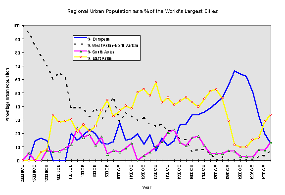
Figure 1:
Regional Urban Population as a % of the Worlds Largest Cities
In
Figure 1 we see the emergence of the worlds first cities in Mesopotamia
and Egypt represented here by the designation West Asia/North Africa. In
the upper left hand corner of the graph the dashed line shows that this
region had 100% of the largest cities on Earth in 2000 BCE.As
other regions developed large cities this monopoly necessarily diminished,
and 4000 years later only a very small percentage of the worlds largest
citieswere in this region. This
is strong evidence of the notion of uneven development and the geographical
movement of the cutting edge of societal complexity.
The
relative size-importance of European cities (indicated by the solid line)
shows a long oscillation around a low level, indicating Europes peripheral
and semiperipheral location in the larger Afro-eurasian world-system. The
long history of the incorporation of the very small systems of Europe into
the expanding Central
System
of West Asia/North Africa is portrayed in Figure 2 (see also Chase-Dunn
and Hall, Chapter 9). Europe had been firmly incorporated into the trade
networks of the Central System during the bronze and iron ages. Figure
1 indicates that by around 1450 CE Europe began a long rise. It passed
East Asia in 1825 CE and peaked in 1850, and then underwent a rapid decline
in importance as indicated by the relative size of largest cities.
Recall
that all the largest cities on Earth, including those in the Americas and
Oceania, are in the denominator of our measure of importance. So in the
decades of the 20th century the percentages shown in Figure
1 do not add up to 100% because some of the largest cities are in none
of the regions tracked (e.g. New York,Mexico
City, etc.).When we use changing
interaction network boundaries, as we have done in earlier research, these
new large cities are included within the Central System, but the contribution
of this study is to see what happens when we hold regions constant. Thus
Figure 1 indicates that the relatively smaller and older European cities
(e.g. London and Paris), were surpassed by the much larger American and
Japanese cities in the 20th century.
The
trajectory of Europe displayed in Figure 1 supports part of Gunder Franks
(1998) analysis, but contradicts another part. The small cities of Europe
in the early period indicate its peripheral status vis a vis the
core regions of West Asia/North Africa, South Asia and East Asia. As Frank
argues, Europe did not best East Asia (as indicated by city sizes) until
the eighteenth century.But the long
European rise, beginning in the fifteenth century, contradicts Franks
depiction of a sudden and conjunctural emergence of European hegemony.Based
on relative city sizes it appears that the rise of Europe occurred over
a period of 500 years.
For
East Asia we see in Figure 1 a rapid rise that began in 1200 BCE with the
emergence of the first states in the Yellow River valley.This
was followed by a small decline and then another burst of relative urban
growth that began in 361 CE and that rose to a peak in 800 CE, another
decline, and then a further rise to the highest peak of all in 1350 CE.Then
there was a small decline and another peak in 1800. Not until 1825 was
East Asia bested by the European cities after a decline that started in
1800 and continued until 1914, when a recovery began. The European cities
were bested again by the East Asian citiesbetween
1950 and 1970 during the rapid decline of the European cities in terms
of their size-importance among the worlds largest cities. This most recent
rise of the East Asian cities isa
consequence of the upward mobility of Japan and the East Asian NICs in
the global political economy.Smith
and Timberlake (2001) have demonstrated the contemporary rising importance
of East Asian cities in the global airline transportation network.
Franks
depiction of a sudden and radical decline of China that began in 1800 CE
is supported in Figure 1.His analysis,
which focuses on the period from 1400 to 1800 CE, does not examine the
relative decline of East Asian predominance that began in 1350 and the
rise to a new peak that began in 1650 as indicated in Figure 1.
The
South Asian cities indicate how this region has fared during the long integration
of the Afro-eurasian system.In Figure
1 the South Asian cities are indicated by the line with triangles.The
early emergence of cities in the Indus river valley can be seen, as well
as their demise, and then the rise of the Gangetic states that peaked,
in terms of city size importance, in 200 BCE.The
Indic cities disappeared completely from the worlds twenty largest cities
in 1200 CE, but then rose to another peak in 1500 corresponding with the
Mughal empire.In 1988 the South
Asian cities had risen once again to a level as high as they had had between
1650 and 1700 CE.
The
Rise of Europe
Figure
2 shows the largest cities in each region from 1400 to 1988 CE. This, and
the following figures, differ from Figure 1 in that they are not percentages
of the worlds largest cities, but are just graphs of the city sizes for
each region. The most striking feature is the geometric growth rate of
city sizes that began in Europe in the 19th centuryand
spread to East Asia, South Asia and West Asia/North Africa. [8]
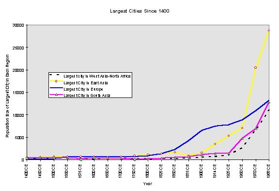
Figure 2: Largest Cities
in each Region Since 1400 CE
New
York, which became the largest city in the world by 1925, beating out London,
is thus not included because we are studying constant regions. Tokyo, the
third largest city in 1925, had become the largest city on Earth by 1970,
and Osaka held third place in that year. By 1980 Tokyo was still first,
but Mexico City held second place, and Sao Paolo was in fourth place.
The
geometric growth rate in the last two centuries obscures, in Figure 2,
important fluctuations in the period from 1400 to 1850. These are germane
to Franks argument about the relative centrality of China and Europe.Figure
3 excludes the period after 1850 in order to show these fluctuations.
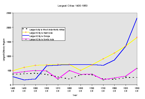
Figure 3: Largest Cities in each Region, 1400-1850 CE
During
the period between 1400 and 1850 the largest cities in South Asia and in
West Asia/North Africa did not increase in size. Rather they fluctuated
around a level that was smaller than the largest East Asian cities at the
beginning of the period, but larger than the largest cities in medieval
Europe. Beginning in 1500 the largest European city, Constantinople, began
a rapid period of growth that achieved the size of the largest city in
East Asia (Beijing) by 1550.European
and Chinese cities were similarly large until 1700, when Beijing began
another period of rapid growth. European growth experienced another upsurge
after 1750 with the mushrooming of London, but the size of London did not
equal that of Beijing until 1825. Within East Asia, Tokyo did not become
larger than Beijing until 1900.
The
patterns shown in Figure 3 are quite similar to those to be found in Figure
4, a graph of the sum of the three largest city populations in each region,
except that the most recent European rise is shown to have begun earlier,
in 1600.
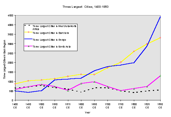
Figure 4: Three Largest
Cities in each Region, 1400-1850 CE
Our
examination of the largest cities in Europe and East Asia further reflects
upon Franks (1998) characterization of the centrality of China and the
rise of European hegemony. While we have contended above that the European
rise began much earlier than Frank describes (shown in Figures 1-4 above),
this early rise appears to have been mainly due to the growth of Ottoman
Constantinople.Though Constantinople
was within the continent of Europe as we have defined it, Frank might contend
that crediting the Christian Europeans of later fame with the success of
the Ottoman Turks is unfair, and that this does not challenge his hypothesis
of the conjunctural nature of European hegemony.
But
there are some other facts that need to be taken into account here. The
second and third largest cities in Europe in 1500 were Paris and Venice,
followed by Naples and Milan.From
1500 to 1600 Paris grew from 185,000 to 245,000 and the other large cities
of Christian Europe grew at a similar pace.So
the early upsurge was not due only to the growth of Constantinople.Christian
Europe was also experiencing a sixteenth century boom period. This does
not dispute the relatively greater centrality of China in this period,
but it does suggest that Christian Europe did not remain a peripheral backwater
until it finally sprang to hegemony at the last minute in the 18th
century.
Constantinoples
size leveled off at 700,000 in 1600 and it stayed at that size until 1700,
after which it began to decline. In this same period the largest cities
of Christian Europe were growing rapidly. London grew larger than Constantinople
by 1750.
City
Synchronicity
This
section replicates our study of synchronous changes in West and East Asian
city systems. We have excluded the South Asian and European regions from
this analysis because they do not reveal synchronicity with the other regions
or with each other. There are two main differences between what we have
done in this study and what we did in earlier work. The first is that we
have grouped the cities according to constant regions rather than spatially
changing political/military interaction networks (PMNs), as described above.
So the West Asia/North Africa region contains cities in this region over
the whole time period rather than the expanding Central PMN studied by
Chase-Dunn and Willard (1993) and Chase-Dunn and Hall (1997). The main
difference due to this change is that emerging cities in the Aegean and
points west are not included in the West Asian/North African region, whereas
they were included in the Central PMN.This
might reduce the degree of synchronicity found because most of the Greek
and Roman cities are in the European region, and an important component
of the synchronicity found in earlier work was that between the rise and
fall of the Roman and Han empires.
The
other difference from earlier research is the use of a five-city SPI rather
than a three-city SPI. This uses more of the cities in each region in the
calculation of the SPI, and so should be a superior indicator of the city-size
aspect of regional city systems. In practice the values are probably not
greatly different from those obtained using only the three largest cities.
The Standardized Primacy Index (SPI) is a statistic that was invented for
comparing city size distributions (Walters 1985).It
calculates a single number from the population sizes of the largest cities
in a region based on deviations from the rank-size rule.
The
rank-size rule hypothesizes that the largest city will be twice as large
as the second largest city, three times as large as the third largest,
and etc.The SPI calculates the average
deviation from this standard in a manner similar to the Chi squared statistic,
and the resulting value is standardized by dividing by the number of
cities used to calculate the SPI. This makes it possible to compare city
size distributions with data on different numbers of cities. The SPI takes
a value of zero when a city size distribution meets the rank-size rule.
Negative values indicate a flatter distribution and positive values indicate
a steeper one.
In
addition to the SPI, we used two other indicators of changes in regional
city systems.These are:
·the
population size of the largest city, and
·the
sum of the populations of the three largest cities.
Figure
5 shows our replication of the Eastern-Western comparison based on the
five-city SPI and using spatially constant regions. Visual inspection of
Figure 5 suggests a definite correlation between the rise and fall of steep
and flat city size distributions in these distant regions from 800 BCE
to 1600 CE. Before and after this period there is no correspondence between
East and West Asian city size distributions.The
synchronous Pearsons r correlation coefficient produced by the values
in Figure 5 is .32, and this approaches, but does not reach, statistical
significance.

Figure 5: West Asian and East Asian 5-city Standardized Primacy Indices
Figure
10.7 in Chase-Dunn and Hall (1997:217), based on a three-city SPI and comparing
the Central and East Asian PMNs, finds a synchronous correlation of .44
and this is statistically significant at the .03 level.We
suspect that the somewhat weaker correlation produced in this study is
due to the fact that Rome is not included in the West Asian/North African
region, whereas it was included in the Central PMN.The
correlation between Roman and Han events and development, studied closely
by Teggart (1939), was an important piece of the synchronicity of the Afro-eurasian
system.That we find a substantial
degree of synchronicity even when Rome is excluded is additional support
for the hypothesis that East and West Asian growth/decline processes were
linked in some way.
Visual
inspection of Figure 5 also suggests a lead-lag relationship between East
and West Asian city size changes. The West Asian/North African city size
distribution seems to be leading the ups and downs by a lag of one or two
hundred years.This may be an important
clue to the nature of the causal relations that link the two regions, but
this suggested lag needs to be investigated using more temporally fine
data. The long periods between measured city sizes in the Chandler data,
especially before 1000 CE, make any statements about synchronicity or lagged
relationships open to a good degree of doubt.On
the other hand, our replication of the synchronicity found in empire
size data using temporally finer time points increased
the correlation
found between the East Asian and Central PMNs (Chase-Dunn, Manning and
Hall 1999).City population data
for more time points and shorter intervals needs to be assembled to see
how city synchronicity fairs with temporally finer data.
Figure
6 shows the trajectories of changes in the population sizes of the largest
cities in East and West Asia over the same period as examined in Figure
5. The Pearsons r synchronous correlation coefficient of .55, significant
at the .003 level, further supports the hypothesis of East-West Asian city
synchronicity.
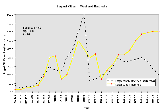
Figure 6: Largest Cities
in West Asia/North Africa and in East Asia
Visual
inspection of Figure 6 also suggests a lead-lag relationship, but it is
more complicated than what is indicated in Figure 5. The temporal lead
of changes in direction (growth and decline) seems to shift back and forth
between West Asia/North Africa and East Asia. For example, the decline
in the size of the largest city that began in East Asia in 800 CE did not
start in West Asia until 900 CE, and the rise that began in East Asia in
1000 CE did not start in West Asia until 1150 CE. On the other hand the
earlier rise and decline seems to have been led by West Asia. Again, these
lag structures require further investigation that uses more temporally
fine data with measurement points that are closer together.
Figure
7 includes data on the three largest cities in each region. The correlation
coefficient further supports the hypothesis of city synchronicity. Visual
inspection suggests another complicated lead-lag relationship with both
regions leading during different periods.
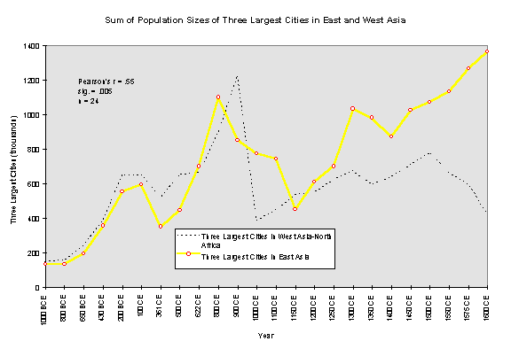
Figure 7: Three Largest
Cities in East Asia and West Asia/North Africa
The
question of causal explanations of the East/West synchronicity of city
and empire growth-decline sequences in this period has been discussed in
earlier studies (Chase-Dunn and Willard 1993; Chase-Dunn and Hall 1997;
Chase-Dunn, Manning and Hall 1999). Basically these boil down to the following
possibilities:
1.Long-distance
trade between these distant regions transmitted economic forces great enough
to bring them into a synchronous pattern of growth and decline.
2.The
cycle of the rise and fall of semiperipheral (or peripheral) states in
Central Asia the steppe nomad confederations that periodically attacked
the agrarian empires of the East and the West brought the East and West
Asian systems into synchronicity.
3.It
is possible that epidemic diseases periodically swept across Afroeurasia
causing synchronous waves of urban depopulation and disrupting large empires.
4.Some
force exogenous to both regions created a synchronous pattern of expansion
and contraction.The only candidate
is climate change.
Of
probable relevance is the fact that the South Asian region, spatially in
between the Eastern and Western Asian regions, was not brought into either
city or empire synchronicity with the others (Chase-Dunn and Hall 1997,
Chase-Dunn Manning and Hall 2000).And
the apparent lack of any synchronicity before 800 BCE or after 1600 CE
is also an important clue. The possibility of a Western temporal priority
suggested by visual inspection of Figure 5 above, would also be important
because causality is assumed to go forward, but not backward, in time.
Conclusions
We
can report additional support for the hypothesis of city synchronization
between 800 BCE and 1600 CE for the distant regions of East Asia and West
Asia/North Africa. The causality that resulted in this phenomenon is still
unknown. What is needed is the operationalization for the relevant regions
and time period of measures of the main hypothesized causal variables:
climate change, warfare, and long-distance trade (e.g. Chase-Dunn 1995).
Further research will also improve upon the city and empire size data,
and should investigate the relationship between these within and across
regions (e.g. Chase-Dunn, Alvarez and Pasciuti 2002).
Our
examination of the problem of the relative importance of regions relies
exclusively on the population sizes of cities, a less than ideal indicator
of power and relative centrality as discussed in the introductory section
of this paper. Nevertheless, our results suggest some possible problems
with Andre Gunder Franks (1998) characterization of the relationship between
Europe and China before and during the rise of European hegemony. Franks
contention that Europe was primarily a peripheral region relative to the
core regions of the Afro-eurasian world-system is supported by the city
data, with some qualifications.Europe
was for millennia a periphery of the large cities and powerful empires
of ancient West Asian and North Africa. The Greek and Roman cores were
instances of semiperipheral marcher states that conquered important parts
of the older West Asian/North African core. After the decline of the Western
Roman Empire, the core shifted back toward the East and Europe was once
again importantly peripheral.
The
synchronicity findings support the idea proposed in Frank and Gills (1994)
that there was an integrated Afro-eurasian world-system much earlier than
most historians and civilizationists suppose. But we cannot yet be certain
that interaction networks were important causes of the synchronicity, and
if they were, we do not know which kind of interaction was most important.
Counter
to Franks contention, however, the rise of European hegemony was not a
sudden conjunctural event that was due solely to a developmental crisis
in China. The city population data indicate that an important renewed core
formation process had been emerging within Europe since at least the 14th
century.This was partly a consequence
of European extraction of resources from its own expanded periphery. But
it was also likely due to the unusually virulent form of capitalist accumulation
within Europe, and the effects of this on the nature and actions of states.
The development of European capitalism began among the city-states of Italy.
It spread to the European interstate system, eventually resulting in the
first capitalist nation-state the Dutch Republic of the seventeenth century
as well as the later rise of the hegemony of the United Kingdom of Great
Britain in the nineteenth century. This process of regional core formation
and its associated emphasis on capitalist commodity production further
spread and institutionalized the logic of capitalist accumulation by defeating
the efforts of territorial empires (Hapsburgs, Napoleonic France) to return
the expanding European core to a more tributary mode of accumulation.
Acknowledging
some of the uniquenesses of the emerging European hegemony does not require
us to ignore the important continuities that also existed as well as the
consequential ways in which European developments were linked with processes
going on in the rest of the Afroeurasian world-system.
The
more recent emergence of East Asian cities as again the very largest cities
on Earth occurred in a context that was structurally and developmentally
distinct from the multi-core system that still existed in 1800 CE. Now
there is only one core because all core states are directly interacting
with one another. While the multi-core system prior to the eighteenth century
was undoubtedly systemically integrated to an important extent, it was
not as interdependent as the global world-system has now become.
A
new East Asian hegemony is by no means a certainty, as both the United
States and German-led Europe will be strong contenders in the coming period
ofhegemonic rivalry (Bornschier
and Chase-Dunn 1999). In this competition megacities may be more a liability
than an advantage because the costs of these huge human agglomerations
have continued to increase, while the benefits have been somewhat diminished
by the falling costs of transportation and communication.Nevertheless
megacities will continue to be an indicator of predominance because societies
that can afford them will have demonstrated the ability to mobilize huge
resources.
References
Abu-Lughod,
Janet Lippman 1989.
Before European Hegemony The World System A.D. 1250-1350
New York: Oxford University Press.
Algaze,
Guillermo 1993 The Uruk World System: The Dynamics of Expansion of Early
Mesopotamian Civilization Chicago: University of Chicago Press.
Bairoch,
Paul 1988 Cities and Economic Development Chicago: University of
Chicago Press.
Barfield,
Thomas J. 1989 The Perilous Frontier: Nomadic Empires and China.
Cambridge, MA.: Blackwell
Bornschier,
Volker and Christopher Chase-Dunn (eds.) 1999 The Future of Global Conflict.
London: Sage
Bosworth,
Andrew 1995 "World cities and world economic cycles" Pp. 206-228 in Stephen
Sanderson (ed. ) Civilizations and World Systems. Walnut Creek,CA.:
Altamira.
Brown,
Barton M. 1987 Population estimation from floor area, Behavior Science
Research
21:1-49.
Chandler,
Tertius 1987 Four Thousand Years of Urban Growth: An Historical Census.
Lewiston,N.Y.: Edwin Mellon Press
Chase-Dunn,
Christopher 1985 "The system of world cities: A.D. 800-1975." Pp. 269-292
in Michael Timberlake (ed.) Urbanization in the World-Economy, New
York:Academic Press.
Chase-Dunn,
C and Thomas D. Hall 1997 Rise and Demise: Comparing World-Systems
Boulder, CO.: Westview Press.
Chase-Dunn,
C. , Susan Manning and Thomas D. Hall 2000 Rise and fall: East-West synchronicity
and Indic exceptionalism reexamined, Social Science History. 24,4:727-754.
Chase-Dunn, C. and Alice Willard,1993 "Systems of cities and world-systems:
settlement size hierarchies and cycles of political centralization, 2000
BC-1988AD" A paper presented at the International Studies Association meeting,
March 24-27, Acapulco.IROWSWorking
Paper #5. http://www.irows.ucr.edu/papers/irows5/irows5.htm
Chase-Dunn,
C. Alexis Alvarex and Daniel Pasciuti 2002 Power and Size: urbanization
and empire formation in world-systems. Presented at the annual spring
conference on the Political Economy of World-Systems, Institute for Research
on World-Systems, University of California, Riverside, May 4. http://irows.ucr.edu/research/citemp/isa02/isa02.htm
Ember,
Melvin 1973 Archaeological indicator of matrilocal versus patrilocal residence,
American
Antiquity
38:177-182.
Frank,
Andre Gunder 1992 "The Centrality of Central Asia" Comparative Asian
Studies Number 8.
______
1998 Reorient: Global Economy in the Asian Age. Berkeley: University
of California Press.
Frank,
Andre Gunder and Barry Gills 1994 The World System: 500 or 5000 Years?
London: Routledge.
Hassan,
Fekri A. 1981 Demographic Archaeology. New York: Academic Press.
Kowalewski,
Stephen A. 1982 "The evolution of primate regional systems" Comparative
Urban Research 9,1:60-78.
Lattimore,
Owen 1940 Inner Asian Frontiers of China. New York: American Geographical
Society.
Pasciuti,
Daniel and Christopher Chase-Dunn 2002 Estimating the Population Sizes
of
Cities
IROWS Working Paper #7, http://irows.ucr.edu/research/citemp/estcit/estcit.htm
Smith,
David A. and Michael Timberlake 2001"World City Networks and Hierarchies,
1977-1997: An Empirical Analysis of Global Air Travel Links," American
Behavioral
Scientist
44,10:1656-1678.
Taagepera,
Rein 1978a "Size and duration of empires: systematics of size" Social
Science Research 7:108-27.
Teggart,
Frederick J. 1939 Rome and China: A Study of Correlations in Historical
Events Berkeley: University of California Press.
Walters,
Pamela Barnhouse 1985 "Systems of cities and urban primacy: problems of
definition and measurement." Pp.63-86 in Michael Timberlake (ed.) Urbanization
in the World-Economy, New York: Academic Press.
Wilkinson,
David 1987 "Central Civilization." Comparative Civilizations Review
17:31-59.
______1991
"Core, peripheries and civilizations." Pp. 113-166 in Christopher Chase-Dunn
and Thomas D. Hall (eds.) Core/Periphery Relations in Precapitalist
Worlds, Boulder, CO.: Westview.
______1992a
"Decline phases in civilizations, regions and oikumenes." A paper presented
at the annual meetings of the International Studies Association, Atlanta,
GA. April 1-4.
______
1992b "Cities, civilizations and oikumenes:I." Comparative Civilizations
Review 27:51-87 (Fall).
_______
1993 Cities, civilizations and oikumenes:II Comparative Civilizations
Review 28
NOTE