Power and Size:
Urbanization and Empire
Formation in World-Systems
Christopher Chase-Dunn
chriscd@mail.ucr.edu
Alexis Alvarez
alexisalvarez@earthlink.net
Institute
for Research on World-Systems
University
of California, Riverside
DRAFT
01-05-02
(5360
words)
Abstract: This paper contains an overview of earlier research on city
and empire growth/decline phases and new evidence on the relationship between
urban growth, city-size distributions and the rise and fall of empires in
separate world-systems that merged into a single global system over the past
four millennia.
The Neo-Assyrian Empire at its largest in 650 BCE.
To be presented at the Comparative Social Analysis Workshop, Center For Comparative Social Analysis, Department of Sociology, UCLA, January 24, 2002. An earlier version was presented at the session on “Systems of cities: past and present” at the annual meeting of the American Sociological Association, Anaheim, August 21, 2001.
The paper is available at http://irows.ucr.edu/research/citemp/powersize.htm
Earlier research has demonstrated the utility of
studying settlement systems and networks of interacting polities as windows on
the historical development of social complexity and hierarchy. By knowing the
population sizes of settlements and the approximate territorial sizes of states
and empires we can compare rather different time periods and regions in order
to discover both regularities and uniquenesses.
This paper briefly summarizes the results of earlier
studies using city and empire sizes and presents new results on the
relationships between changes in urban populations, city-size distributions and
the territorial sizes of states and empires. Archaeologists often assume that
the concentration of political power can be inferred from the rise of a size
hierarchy of settlements – increases in the steepness of the settlement size
distribution (e.g. Kowalewski 1982). This hypothesis can be tested by using
existing data, though more certain results await the improvement and greater
temporal resolution of data on city and empire sizes.
Chase-Dunn and Willard (1993) examined urban growth and
city-size distributions in nine different regional political/military networks
(PMNs) [1]
using data on city sizes from Tertius Chandler’s (1987) compendium.
Political/military networks (PMNs) are interstate systems – systems of adjacent
conflicting and allying states. David Wilkinson (1987) bounds these expanding
and contracting systems of states as they merge or become incorporated into
what Wilkinson calls the “Central System.” Chase-Dunn and Willard (1993)
plotted changes in the Standardized Primacy Indices (a measure of the steepness
of the city-size distribution) over time, and read descriptions of what was
happening in the different systems to examine the hypothesis that changes in
the city-size distribution was related to changes in the degree of political
integration and the centralization of state power in nine different PMNs. They
also accidentally discovered a synchronicity of changes in city size
distributions and phases of urban growth/decline in the East Asian and the West
Asian-Mediterranean PMNs over a long period from about 500 BCE to about 1500
CE.[2]
This
latter discovery led to further research using data on the territorial sizes of
empires gathered by Rein Taagepera (1978a, 1978b, 1979,1997). That analysis
(Chase-Dunn, Manning and Hall 2000) found additional evidence for synchronicity
between the East Asian and the West Asian-Mediterranean PMNs over this same two
thousand year period, and confirmed what had also been indicated by scant city
size data from India, that the Indic PMN was marching to a different drummer.
These synchronicity results were further confirmed by
additional analysis of the city data by Chase-Dunn and Manning (1998). That
study examined synchronicities by comparing constant regions rather than
PMNs. PMN boundaries change over time because of the expansion of the Central
System, whereas specified regions that are held constant over time can
constitute a different, but related, unit of analysis. Chase-Dunn and Manning
found support for the synchronicity phenomenon using constant regions, and so
this phenomenon is not likely to be an artifact of the way in which units of
analysis have been constructed.
Power,
Urban Growth and Urban Size Hierarchies
This paper returns to the question asked in the
Chase-Dunn and Willard (1993) study about the relationship between urban
growth, city-size distributions and the rise and fall of empires. What is the
relationship between the size of settlements and power in intergroup relations?
Under what circumstances does a society with greater population density have
power over adjacent societies with lower population density, and when might
this relationship not hold? Population
density is often assumed to be a sensible proxy for relative societal power.
Indeed Chase-Dunn and Hall employ high relative population density as a major
indicator of core status within an intersocietal system (Chase-Dunn and Hall
1997). But Chase-Dunn and Hall are careful to distinguish between
“core/periphery differentiation” and “core/periphery hierarchy.” Only the
latter constitutes actively employed intersocietal domination or exploitation,
and Chase-Dunn and Hall warn against inferring power directly from differences
in population density.
In many world-systems military superiority is the key
dimension of intersocietal relations. Military superiority is generally a
function of population density and the proximity of a large and coordinated
group of warriors to contested regions. The winner of a confrontation is that
group that can bring the larger number of warriors together quickly. This general demographic basis of military
power is modified to some extent by military technology, including
transportation technologies. Factors such as better weapons, better training in
the arts of war, faster horses, better boats, greater solidarity among soldiers
and their leaders, as well as advantageous terrain, can alter the simple
correlation between size and power.
The most important general exception (in comparative
evolutionary perspective) to the size/power relationship is the phenomenon of semiperipheral
development (Chase-Dunn and Hall 1997:Chapter 4). The pattern of uneven development by which formerly more complex
societies lose their place to “less developed” societies takes several forms
depending on the institutional terrain on which intersocietal competition is
occurring. Less relatively dense
semiperipheral marcher chiefdoms conquer older core chiefdoms to create larger
chiefly polities. Likewise, semiperipheral marcher states, usually recently
settled peripheral peoples on the edge of an old region of core states,
frequently are the agents of a new core-wide empire based on conquest. Less
dense semiperipheral Europe was the locus of a virile form of capitalism that
condensed in a region that was home to a large number of unusually proximate
semiperipheral capitalist city-states. This development, and the military
technology that emerged in the competitive and capitalist European interstate
system, made it possible for less dense Europe to erect a global hegemony over
the more densely populated older core regions of Eurasia. The more recent
hegemonic ascent of formerly semiperipheral national states such as England and
the United States are further examples of the phenomenon of semiperipheral
development.
The phenomenon of semiperipheral development does not
totally cut away the general observation of a correlation between power and
size. What it shows is that this correlation can be overcome by other factors,
and that these processes are not entirely random. Denser core societies are
regularly overcome or out competed by less dense semiperipheral societies, but
it does not follow that all semiperipheral or peripheral regions have such an
advantage. On the contrary, the majority of low density societies are subjected
to the power of more dense societies.
Semiperipheral development is a rather important exception to this
general rule.
Why
should a city system have a steeper city size distribution when there is a
greater concentration of power? The simple answer is that large settlements,
and especially large cities, require greater concentrations of resources to
support their large populations. This is why population size has itself been
suggested as an indicator of power (Taagepera, 1978a: 111). But these resources
may be obtainable locally and the settlement size hierarchy may simply
correspond to the distribution of ecologically determined resources. People
cluster near oases in a desert environment. In such a case it is not the
political or economic power of the central settlement over surrounding areas
that produces a centralized settlement system but rather the geographical
distribution of necessary or desirable resources. In many systems, however, we
have reason to believe that relations of power, domination and exploitation do
affect the distribution of human populations in space. Many large cities are as
large as they are because they are able to draw upon far-flung regions for food
and raw materials. If a city is able to use political/military power or
economic power to acquire resources from surrounding cities it will be able to
support a larger population than the dominated cities can, and this will
produce a hierarchical city size distribution.
Of
course the effect can also go the other way. Some cities can dominate others
because they have larger populations, as discussed above. Great population size
makes possible the assembly of large armies or navies, and this may be an
important factor creating or reinforcing steep city size distributions.
The
relationship between power and settlement systems is contingent on technology
as well as political and economic institutions. Thus we expect to find that the
relationship between urban growth and decline sequences and the growth decline
sequences of empires varies across different systems or in the same regional
system over time as new institutional developments emerge. We know that the
development of new techniques of power, as well the integration of larger and
larger regions into systems of interacting production and trade, facilitates
the emergence of larger and larger polities as well as larger and larger
cities. Thus there is a secular trend at the global level and within
regions between city sizes and polity sizes over the past six millennia. But
the question we are asking here is about finer temporal and spatial
relationships. Do cities and empires rise and fall together? Are there
important exceptions to this pattern? What are the causalities involved?
We will further examine the relationship between power,
urban growth and settlement size hierarchies by comparing trends in the
growth/decline sequences of city populations and the territorial sizes of
empires. Our units of analysis will be:
- Political/Military Networks (PMNs), otherwise
called interstate systems;
- Constant Regions[3],
in order to see how spatial boundaries might be related to patterns in the
city-empire relationship; and
- Polities (states and empires), because the
simplest form of the hypothesis of a causal relationship between power and
urbanization is that larger states can afford to create larger cities.
And
we will examine the temporal relations between the simple sizes of cities and
empires, as well as size distributions of cities and the size of empires
when data are available.
 Measurement
of the population sizes of cities and the territorial sizes of empires is not
without difficulties, especially for early periods. How can we know the number
of people who reside in Los Angeles today? We use the most recent census, a
survey of “residents” conducted by the U.S. federal government. What are the
spatial boundaries of “Los Angeles”? Do we mean the city of Los Angeles, Los
Angeles County, the contiguous built-up area that constitutes “greater Los
Angeles,” or a definition based on the proportion of the local population that
is employed in “Los Angeles”? Does “Los Angeles” include San Diego? Nighttime
satellite photos of city lights reveal a single unbroken gigalopolis from Santa
Barbara to Tijuana:
Measurement
of the population sizes of cities and the territorial sizes of empires is not
without difficulties, especially for early periods. How can we know the number
of people who reside in Los Angeles today? We use the most recent census, a
survey of “residents” conducted by the U.S. federal government. What are the
spatial boundaries of “Los Angeles”? Do we mean the city of Los Angeles, Los
Angeles County, the contiguous built-up area that constitutes “greater Los
Angeles,” or a definition based on the proportion of the local population that
is employed in “Los Angeles”? Does “Los Angeles” include San Diego? Nighttime
satellite photos of city lights reveal a single unbroken gigalopolis from Santa
Barbara to Tijuana:
So where is Los Angeles?
We want to use the contiguous built-up area as our main way of spatially
defining cities. For early cities we do not have official, and ostensibly
complete, census figures. Thus we rely on methods that archaeologists and
students of early urbanization have developed to estimate the population sizes
of cities.
These
involve, for example, determining the spatial size of the city and then
estimating the population density per unit of area and so estimating the total
population. Population density varies depending upon the size of families, the
nature of dwellings, the amount of non-residential area within settlements, and
cultural differences. Anthropologists and archaeologists have made an important
effort to produce reliable methods for estimating population sizes from
residential areas (Brown 1987).
Tertius Chandler (1987) used reports about the number of soldiers to estimate city sizes, assuming that an army of men represents, on the average, about ten percent of the population of the city in which the army resides. Such estimates are obviously error-prone. Another problem with existing data on both city and empire sizes is that they were produced from surveys of both secondary and primary sources that are now, in many cases, obsolete because more recent and better research has been published by archaeologists, epigraphers and historians. Chandler’s compendium was mainly based on his thorough survey of the contents of the main library at the University of California, Berkeley over the four decades prior to its publication in 1987. A new project to improve upon Chandler’s compendium of city sizes is under way at the Institute for Research on World-Systems at the University of California, Riverside.
Estimating the territorial sizes of empires is also
problematic. Taagepera used atlases and maps to produce his estimates of the
spatial sizes of empires from 3000 BCE to the present. But the boundaries of
empires are not usually formally specified, but are rather a matter of degrees
of control that fall off with distance from the central region. Archaeological
evidence of the presence of a core culture in a peripheral region does not
prove the existence of control, because many core polities have established
colonial enclaves in distant peripheries to facilitate trade (e.g. Stein 1999).
So the estimation of empire sizes is also fraught with difficulties. But, as
with city sizes, a significant improvement of accuracy, temporal resolution and
coverage would result from a renewed effort to code empire sizes using recently
published materials. This is another task that the IROWS City-Empire Research
Working Group will undertake.[4]
Dating is also a major problem in studying temporal
relationships in the ancient world-systems. In this paper we utilize the years
originally supplied by Taagepera and Chandler. But the dating of events and
city size estimations for the millennia BCE is a matter of continuing dispute
among scholars of ancient history. For ancient Western Asia the Egyptian
dynastic dates are used, but these have been repeatedly revised with an error
margin of around 25 years. This is a threat to any study of temporal
correlations.
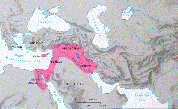
Mesopotamia
The first PMN we shall examine is that of
Mesopotamia from 2800 to 550 BCE. It is mistaken to speak of a single West
Asian/North African world-system for this whole period. Rather two core areas –
Egypt and Mesopotamia – were undergoing developmental processes that were only
weakly linked, especially at first. As both of these systems expanded their
trade networks and political/military interaction networks they came into
contact with one another. The prestige goods nets (PGNs) became linked as early
as 3000 BCE (Marfoe 1987) or as late as 2250 BCE (Wilkinson 1992), while the
Mesopotamian and Egyptian political/military networks became linked by the
Egyptian expedition to Syria (about 1520 BCE). We examine the relationship
between the population size of the largest city and the territorial size of the
largest state or empire in a region as these change over time. The hypothesis
of a correspondence between urbanization and the size of polities should reveal
a positive correlation in these two measures over time. The data on city population
sizes are especially sparse for early millennia and the time points of
estimates are widely spaced, making temporal correlation risky. For Mesopotamia
our data set is thus:
|
Year (BCE) |
Empire Size (square
megameters x10) |
Empire Name |
City Size (thousands) |
City Name |
|
-2800 |
1 |
Kish |
80 |
Uruk* |
|
-2500 |
3 |
Kish |
50 |
Uruk* |
|
-2400 |
5 |
Lagash |
|
|
|
-2300 |
65 |
Akkadian |
36 |
Agade*# |
|
-2200 |
25 |
Akkadian |
|
|
|
-2100 |
3 |
Ur |
|
|
|
-2000 |
10 |
Sumer |
65 |
Ur |
|
-1900 |
0 |
|
|
|
|
-1800 |
10 |
Old Assyria |
29 |
Mari |
|
-1700 |
25 |
Babylon |
|
|
|
-1600 |
16.6 |
Babylon |
60 |
Babylon |
|
-1500 |
10 |
Kassite |
|
|
|
-1450 |
10 |
Kassite |
|
|
|
-1400 |
10 |
Kassite |
|
|
|
-1360 |
21.7 |
Hittites |
45 |
Khattushash
(Hattusa) |
|
-1350 |
5 |
Assyria |
45 |
Khattushash
(Hattusa) |
|
-1300 |
10 |
Assyria |
|
|
|
-1250 |
15 |
Assyria |
|
|
|
-1200 |
25 |
Hittites |
48 |
Khattushash
(Hattusa) |
|
-1150 |
5 |
Assyria |
|
|
|
-1100 |
40 |
Assyria |
|
|
|
-1050 |
15 |
Babylon |
|
|
|
-1000 |
15 |
Babylon |
51 |
Babylon |
|
-950 |
15 |
Babylon |
|
|
|
-900 |
15 |
Babylon |
|
|
|
-850 |
40 |
Assyria |
|
|
|
-800 |
57.9 |
Assyria |
50 |
Calah |
|
-750 |
40 |
Assyria |
|
|
|
-700 |
90 |
Assyria |
|
|
|
-650 |
93.3 |
Assyria |
120 |
Nineveh |
|
-600 |
25 |
Babylon |
|
|
|
-550 |
50 |
Babylon |
|
|
Table 1:Mesopotamian Largest Empires and Cities
*These estimates are
from Modelski (1997). All other estimates are based on Chandler and Taagepera.
#Archaeologists have
not yet decided which of the thousands of tells in Iraq is Agade, the capital
of Sargon’s Akkadian empire.
Table 1 immediately demonstrates
problems of missing data, especially for the third millennium. The time points
for city sizes are far apart, and there are obviously missing cases. We have
Modelski’s (1997) best estimate of the population size of Uruk in 2800 and 2500
BCE, but the largest empire shown in Taagepera’s data is that of Kish, a
city-state that was independent of the much larger empire of Uruk in this period.
This obvious error strongly demonstrates the need for upgrading the data sets
we are using. In the data presented in Table 1 and in the figures and tables
below we have interpolated Taagepera’s dates of changes in the sizes of empires
to regular time intervals (every 50 years in Table 1 and Figures 1 and 2; every
10 years for the other regions in Table 2 and the figures in the Appendix).
Another complication revealed in Table 1 and Figure 1
(below) is as follows: in 1350 and 1200 BCE the largest city is Khattushash (Hattusa),
the capital of the Hittite empire, but the largest empire in the Mesopotamian
region is the Neo-Assyrian Empire. This raises the issue of the proper unit of
analysis – regions or polities – but it also raises a theoretical issue. The
simplest version of the size-power hypothesis is that larger empires can afford
larger cities, and to test this hypothesis we would need temporally
fine-grained data on the size of the largest city within each empire.
For this purpose the unit of analysis should be the polity (states and
empires). But it may also be the case that regions or PMNs experience cyclical
periods of growth and decline in which all the states and cities are growing,
or alternatively that state and city growth is a zero-sum game in which growth
in some results or is related to decline in others. By using and comparing
different spatial units of analysis we can examine these competing hypotheses.
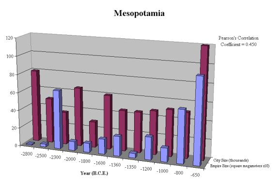
Figure 1: Largest Mesopotamian Cities and Empires
The temporal relationship between the size of the
largest city and the size of the largest empire is positive for the
Mesopotamian case with a positive Pearson’s r correlation coefficient of .59
based on ten time points for which we have data for both variables. This
supports the hypothesis of a causal relationship between these features of the
social landscape, but the positive association could also be due to other
factors or to the secular trending of these characteristics. We will return to
these issues when we have more and better data in the cases to be discussed
below.
Egypt
As with Mesopotamia the data for Egypt are few and
problematic. But using what we have produces the results displayed in Figure 2.
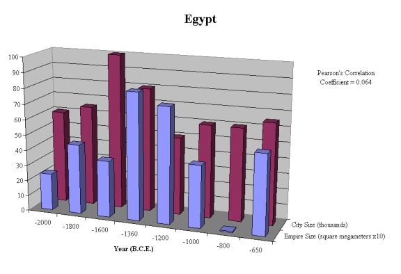
Figure 2: Largest Egyptian Cities and Empires
The temporal relationship between city and empire
sizes in Egypt is also positive, producing a Pearson’s r correlation
coefficient of .52 based on seven time points on which we have data for both
variables. Though there is a secular upward trend, both city and empire sizes
also reveal decline phases and these are roughly synchronous with one another,
though the few estimates of city sizes makes a firm conclusion risky.
Size and Power in Regions
Table 2 presents the bivariate correlation coefficients
between empire and city sizes for all of the regions for which we have
sufficient data to study in this way. It also presents the partial correlations
controlling for year to remove the long-term upward trend between city and
empire sizes. The Americas and Africa do not have enough city size data, though
this deficiency could and should be remedied by a new coding project.
Regional
correlations between city and empire sizes
|
|
Region |
Pearson’s r |
Partial Pearson's r |
# of time points |
Years |
|
|
Egypt |
0.216 |
0.160 |
10 |
2300 B.C.E. - 550 B.C.E. |
|
|
Mesopotamia |
0.784* |
0.763* |
8 |
2800 B.C.E. - 550 B.C.E. |
|
|
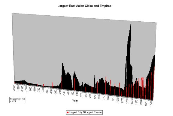
East Asia |
0.473** |
0.122 |
30 |
1360 B.C.E. - 1800 C.E. |
|
|
Europe |
0.892** |
0.876** |
24 |
430 B.C.E. - 1800 C.E. |
|
|
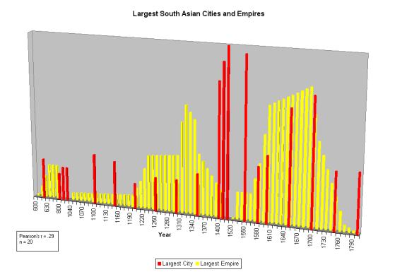
South Asia |
0.286 |
0.126 |
15 |
600 C.E. - 1800 C.E. |
|
|
West Asia |
0.636** |
0.562** |
27 |
2000 B.C.E. - 1500 C.E. |
|
* |
significant at the 0.05 level. |
|
|
|
|
|
** |
significant at the 0.01 level. |
|
|
|
|
Table 2:
Regional correlations between city and empire sizes
Table 2 shows that four of the six regions have
significant positive bivariate correlations between city and empire sizes
(Column 2). This lends support to the contentions discussed above of a causal
interaction between power and size, but these correlations do not shed light on
the question of the direction of the causal effects. Once we have improved data
we plan to employ the test of antecedence to shed light on this.
One problem with the results in the Column Two of Table 2
is that the positive correlations may be due to the secular trends rather than
to medium-term oscillations. Both city and empire sizes increase over time.[5]
In
order to remove the effects of the secular upward trend we could use two
different methods. The first is to compute partial correlations controlling for
year. This is what we have done in Table 2 and the results are in Column Three.
Another method of detrending would compute first differences, the change scores
from one period to the next. The irregular time points of the early city size
data make change score detrending messy, so this should only be done after more
regular intervals of measurement have been established.
The
detrended partial correlations in Column Three of Table 2 show that there are
important differences among regions with respect to the relationship between
city and empire sizes. The main difference between the bivariate and detrended
partial correlations in in the East Asian region. The rather substantial and
statistically significant bivariate correlation of .47 drops to .12 when the
long-term trend is taken out. The result is that only three of the six regions
continue to show a statistically significant positive relationship between
empire and city sizes after detrending. The South Asian correlation also
decreased but it was already low and insignificant. So Mesopotamia, Europe and
West Asia show a rather substantial relationship between size and power, but
South Asia, East Asia and Egypt do not.
We also need to do the same analysis for the other units
of comparison – PMNs and individual empires. And indeed we also will present
results for the correlations of size distributions, as well as correlations
between the largest and second largest cities and empires.
At present we are undertaking an analysis of the
power-size relationship within individual polities, including the modern
colonial empires. We will also examine the relationships among size
distributions of cities and polities, and correlations between the sizes of largest
and second largest cities and empires to examine the question of zero-sum vs.
regional booms. Earlier work already has shown that empires tend to grow
contemporaneously – periods in which the largest empire is growing tend also to
be periods in which the second largest empire in growing in the same region.
This would seem to be counter intuitive, and bears further examination of both
empire and city growth decline sequences.
We may also ask whether or not the causal relations
stable over time within regions? We expect that there may be periodic changes
in the relationship between power and size as new institutions develop. The
rise of capitalism as an alternative source of power to military might and
changes in the relationship between military power and demographic factors most
likely change the nature of the connections between size and power. We know
that empires ceased to increase in territorially size with the demise of the
modern colonial empires. And the contemporary world city system may be unique
in the extent to which some of the largest cities are located in the
semiperiphery rather than in the core. These observations suggest that we
should try to overcome the difficulties encountered in studying the last two
centuries in order to shed more light on the power-size relationship.
This working paper is part of a collaborative project
that seeks to study the processes of social evolution and historical
development by comparing regional systems, and by studying changes in
institutional characteristics over long periods of time. The Institute for
Research on World-Systems at the University of California, Riverside is
beginning the process of upgrading the earlier coding of city and empire sizes
by Chandler and Taagepera. We are working in interdisciplinary collaboration
with a group of scholars associated with the World Historical Systems
subsection of the International Political Economy Section of the International
Studies Association.
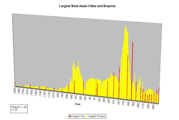
Appendix: (the following
figures are not perfectly accurate with respect to the data included in Table
2. The are presented only for purposes of rough comparison.)

References
Abu-Lughod, Janet Lippman
1989. Before European Hegemony:The World
System A.D. 1250-1350
New
York: Oxford University Press.
Algaze, Guillermo 1993 The Uruk World System: The Dynamics of
Expansion of Early
Mesopotamian Civilization Chicago: University of Chicago Press.
Allen, Mitchell J. 1997
“Contested peripheries: Philistia in the Neo-Assyrian World-System”
PhD
dissertation, Department of Archaeology, University of California, Los Angeles
Barfield, Thomas J. 1989 The Perilous Frontier: Nomadic Empires and
China. Cambridge, MA.:
Blackwell
Bosworth, Andrew 2000
"The evolution of the world city system, 3000 BCE to AD 2000"
Pp.
273-284 in Robert A. Denemark et al
(eds. ) World System History. London:
Routledge.
Brown, Barton M. 1987
“Population estimation from floor area,” Behavior
Science Research
21:1-49.
Chandler, Tertius 1987 Four Thousand Years of Urban Growth: An
Historical Census.
Lewiston,N.Y.:
Edwin Mellon Press
Chase-Dunn, Christopher
1985 "The system of world cities: A.D. 800-1975." Pp. 269-292 in
Michael
Timberlake (ed.) Urbanization in the
World-Economy, New York:Academic
Press.
______ 1992 "The
changing role of cities in world-systems." Pp. 51-88 in Volker Bornschier
and
Peter Lengyel (eds.) Waves, Formations
and Values in the World System World Society
Studies,
Volume 2, New Brunswick, N.J.: Transaction Publishers.
__________ 1995 “
Simultaneities of world-system development: cities, empires and climate
change.” An unfunded proposal submitted to the
National Science Foundation.
http://csf.colorado.edu/wsystems/archive/papers/c-d&hall/prop5/prop5.htm
Chase-Dunn, C and Thomas
D. Hall 1997 Rise and Demise: Comparing
World-Systems Boulder,
CO.:
Westview Press.
___________ 2001 “City and Empire Growth/Decline Sequences in
Ancient
Mesopotamian and Egyptian World-Systems” A paper
presented at the annual
meetings of the International Studies Association,
Chicago, February 24.
Chase-Dunn, C. , Susan
Manning and Thomas D. Hall 2000 “Rise and fall: East-West
synchronicity
and Indic exceptionalism reexamined,” Social
Science History 24,4:727-
754.
Chase-Dunn, C. and Alice
Willard 1993 "Systems of cities and world-systems: settlement
size hierarchies and cycles of political
centralization, 2000 BC-1988AD" A paper
presented at the International Studies Association
meeting, March 24-27, Acapulco.
http://www.jhu.edu:80/~soc/pcid/papers/17/pcidpap17.htm
Chaudhuri, K.N. 1985 Trade and Civilisation in the Indian Ocean:
An Economic History from the Rise
of Islam to 1750. Cambridge: University of Cambridge Press.
Chi, Ch'ao-ting 1963
[1935] Key Economic Areas In Chinese
History: As Revealed in the Development
of Public Works for Water-Control, New York: Paragon Books.
Cioffi-Revilla, Claudio
1991 "The long-range analysis of war," Journal of Interdisciplinary History
21:603-29.
Collins, Randall 1992
"The geographical and economic world-systems of kinship-based and
agrarian-coercive
societies." Review 15,3:373-88
(Summer). Westport, CT.:
Eckhardt, William 1992 Civilizations, Empires and Wars: A
quantitative history of war Jefferson,
NC: McFarland.
Feinman, Gary M. and J. Marcus (eds.) 1998 Archaic States. Santa Fe: School of
American Research.
Fitzpatrick, John 1992
"The Middle Kingdom, the Middle Sea and the geographical pivot of
history."
Review 15,3:477-522 (Summer).
Frank, Andre Gunder 1992
"The Centrality of Central Asia" Comparative
Asian Studies
Number
8.
________ 1993 “The bronze age world system and its
cycles.” Current
Anthropology 34:383-413.
______ 1998 Reorient:: Global Economy in the Asian Age.
Berkeley: University of California
Press.
Frank, Andre Gunder and
Barry Gills 1994 The World System: 500 or
5000 Years? London:
Routledge.
Kowalewski, Stephen A. 1982 "The
evolution of primate regional systems" Comparative
Urban Research 9,1:60-78.
Lattimore, Owen 1940 Inner Asian Frontiers of China. New
York: American Geographical
Society.
Mann, Michael 1986 The Sources of Social Power: A History of
Power from the Beginning to A.D.
1760. Cambridge:
Cambridge University Press.
Marcus, Joyce 1999 “The peaks and valleys of ancient
states.” Pp. 59-94 in G. Feinman
and J. Marcus (eds.) Archaic States. Santa Fe, NM: School of
American
Research.
Marfoe, Leon 1987
"Cedar forest and silver mountain: social change and the development of
long-distance trade in early Near Eastern societies," Pp. 25-35 in M.
Rowlands et al Centre and Periphery in the Ancient World. Cambridge: Cambridge
University Press.
McNeill, William H. 1976 Plagues and People Garden City, NJ:
Anchor Books.
Modelski, George
1997 “Early world cities: extending the census to the fourth millennium,”
Prepared for the annual meeting of the International Studies
Association,Toronto, March 21
__________ 1999
“Ancient world cities 4000-1000 BC: centre/hinterland in the world
system.” Global Society 13,4:383-392.
Modelski, George and
William R. Thompson 1994 Leading Sectors
and World Powers: The
Coevolution of Global Economics and Politics. Columbia, S.C.: University of South Carolina
Press.
Nissen, Hans J. 1988 The Early History of the Ancient Near East,
9000-2000 BC Chicago:
University
of Chicago Press.
Sanderson, Stephen K.
(ed.) 1995 Civilizations and World
Systems. Walnut Creek, CA Altamira.
Schneider, Jane 1991
"Was there a pre-capitalist world-system?" Pp. 45-66 in C. Chase-Dunn
and
T.D. Hall (eds.) Core/Periphery Relations
in Precapitalist Worlds. Boulder, CO.: Westview.
Shin, Kyoung-Ho and
Michael Timberlake 1999 “The global city network, 1977-97” A paper
to
be presented at the annual meeting of the American Sociological Association,
Chicago,
August 10.
Smith, David A. and
Michael Timberlake 1995 “Conceptualizing and mapping the structure
of
the world system’s city system,” Urban
Studies 32,2:287-302.
Stein, Gil J. 1999 Rethinking
World-Systems: Diasporas, Colonies and
Interaction in
Uruk
Mesopotamia. Tucson: University of Arizona Press.
Taagepera, Rein 1978a
"Size and duration of empires: systematics of size" Social Science
Research
7:108-27.
______ 1978b "Size
and duration of empires: growth-decline curves, 3000 to 600 B.C."
Social Science Research, 7 :180-96.
______1979 "Size and
duration of empires: growth-decline curves, 600 B.C. to 600 A.D."
Social Science History 3,3-4:115-38.
_______1997 “Expansion
and contraction patterns of large polities: context for Russia.”
International Studies Quarterly 41,3:475-504.
Teggart, Frederick J.
1939 Rome and China: A Study of
Correlations in Historical Events Berkeley:
University
of California Press.
Walters, Pamela Barnhouse
1985 "Systems of cities and urban primacy: problems of
definition
and measurement." Pp.63-86 in Michael Timberlake (ed.) Urbanization in
the World-Economy, New York: Academic Press.
Wilkinson, David 1987
"Central Civilization." Comparative
Civilizations Review 17:31-59.
______1991 "Core,
peripheries and civilizations." Pp. 113-166 in Christopher Chase-Dunn
and
Thomas D. Hall (eds.) Core/Periphery
Relations in Precapitalist Worlds, Boulder, CO.:
Westview.
______1992a "Decline
phases in civilizations, regions and oikumenes." A paper presented at
the
annual meetings of the International Studies Association, Atlanta, GA. April
1-4.
______ 1992b "Cities, civilizations and
oikumenes:I." Comparative
Civilizations Review 27:51-
87
(Fall).
_______ 1993 “Cities,
civilizations and oikumenes:II”
Comparative Civilizations Review 28