Interdisciplinary Behavioral and Social Science Research
IBSS Interdisciplinary
Team Exploratory Project:
https://www.nsf.gov/funding/pgm_summ.jsp?pims_id=504832
http://www.nsf.gov/pubs/2015/nsf15588/nsf15588.pdf
IBSS-S:
SETPOL:
The
Globalization of Empires and Cities since 1500 BCE
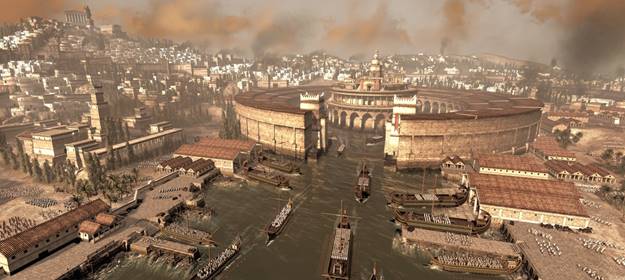
Artist’s conception of the
Cothon, the military harbor of Carthage
PI: Christopher Chase-Dunn (Sociology and IROWS, UCR)
Co-PI: Eugene Anderson (Anthropology, UCR)
Co-PI: David Wilkinson (Political Science, UCLA)
Draft 11-30-15; 12553 words
Project
Calendar Schedule: Submitted to NSF: December 1, 2015; Start date: July 1, 2016; End date: June 30, 2018; Duration: 30 months. Indirect cost
rate= 52%.
PROJECT SUMMARY
This exploratory
project will construct a multidisciplinary theoretical research program and
test hypotheses about the causes of changes in city and empire sizes from the
second millennium BCE to the present in order to shed light on the contemporary
and near future global situation. The
Settlements and Polities (SETPOL) project will inventory explanations of scale
changes from anthropology, sociology and political science and will develop and
populate templates for a graph database that will allow the use of geographical and network analyses for studying
interactions among cities and empires. This database structure will make it
possible to test causal propositions and models derived from the comparative
evolutionary world-systems perspective, geopolitics, and human ecology --
theoretical perspectives that have been developed by sociologists, anthropologists
and political scientists--to construct a multidisciplinary sociohistorical
theoretical research program. The quantitative graph database will include the
territorial sizes of states and empires (polities), the population sizes of
cities and polities, interaction links and climate change in ten world regions
over the past 3500 years. The project will also spatially bound whole
interaction networks by estimating changes in the boundaries and intensities of
human interactions of several kinds: everyday necessities, the trade of high
value goods, the interactions of fighting and allying polities and the
diffusion of ideas and genetic materials. SETPOL will code the power
configurations (unipolar, bipolar, multipolar, etc.) of interstate systems and
the world-system positions of settlements and polities (core, semiperiphery and
periphery) within regional interaction networks. Causal propositions will be
tested using five different units of analysis: individual cities and polities,
networks of interacting cities and polities and spatially constant regions and
the whole Earth as a single context for studying the causes of changes in urban
and polity scales. A research team from archaeology, anthropology, geography,
history, political science, sociology, ecology and climatology will carry out
this first two-year phase. The multidisciplinary theoretical research program
that will be developed will come primarily from anthropology, sociology,
political science and geography, but participation by climatologists,
historians, computer scientists and ecologists will contribute to the
production of an improved database that allows for the use of geographical and
network research methods.
Intellectual Merit
The long-standing upward trends in the sizes of
cities and polities is well known, but still in dispute are the long-term, proximate
and contextual causes of these trends. The SETPOL project will improve upon,
and extend, existing quantitative compilations of estimates of the sizes of cities
and polities to identify those instances in ten world regions in which upsweeps
in polity and city sizes have occurred, and will empirically examine the human
and natural factors that have been hypothesized to be the causes of these
instances of scale change. The project will also identify instances of collapse
in the sizes of polities and cities and will study their causes. The project
will develop best approximations of the growth and intensity of interaction
networks that have constituted economic and political globalization since the
late Bronze Age. The project will employ both standard comparative methods and
recently developed geographical and network approaches to data analysis that
use both GIS spatial analysis and formal network methods. This will contribute
to the scientific understanding of the causes of the emergence of complexity
and hierarchy in human societies and will deepen the understanding of
sociocultural evolutionary processes.
Broader Impacts
Scientifically
formulated and tested explanations of the development of complexity and
hierarchy in human societies will help scholars, educators and policy-makers to
better understand the patterns of historical sociocultural evolution and their
implications for the future of humankind. The project will also allow us to
provide fresh evidence on the comparisons of similarities and differences
across world regions with important implications for explanations of uneven
East/West development – issues that have been totemic and fundamental in the development
of social sciences since the eighteenth century. The results of this research
will have important implications for issues such as societal responses to
climate change, ecological degradation, population density, the changing nature
of the global city system, the rise and fall of hegemonic core powers,
transitions from unipolar to multipolar power situations, as well as resilience
and systemic collapse. The SETPOL
project will make its standardized geospatial data set publicly available and
will coordinate and collaborate with other world historical data consortia.
Participants in the project will develop undergraduate and graduate level
courses and research projects to train students to do multidisciplinary
research and to develop creative infographic presentations for classroom and
general educational use.
Project Description
The
Settlements and Polities (SETPOL) project will use both quantitative estimates
of population sizes of the largest cities in world regions and estimates of the
territorial sizes of largest states and empires to study the causes of changes
in the scale of human institutions. Upsweeps are instances in which the largest
settlement[1]
or polity in a region significantly increases in size for the first time. The
project will use world regions and whole interaction networks (world-systems)
as well as single polities and cities as units of analysis.[2]
This proposed multidisciplinary research is organized around the territorial
sizes of polities[3]
and the population sizes of cities because these are relatively easily
ascertainable quantitative indicators of system size and complexity. Interval
scale metrics are needed in order to tell the difference between small and
large changes in scale. When human
sociocultural systems are studied over long periods of time cyclical processes
of population growth and decline, the rise and fall of large and strong
polities, are empirically evident. This project will employ a systematic method[4]
of differentiating between a “normal” upswing or downswing in which the scale
of sociocultural organization is fluctuating around an equilibrium level and an
event of growth or decline that is significantly greater than the normal
fluctuations (see Figure 1). Focusing on
the largest cities and polities in each region rather than on individual cities
or polities makes these cycles of upswings, downswings, upsweeps and collapses
visible. Are the forces and conditions
that cause upsweeps simply larger than those that cause upswings, or are
different factors involved? Or do they combine in different ways? And are the
causes of upsweeps the same as the causes of collapses but in reverse? The
project will use upswings, upsweeps, downswings, downsweeps and collapses of
city and polity sizes as dependent variables to be explained. This project will
study city and polity sizes in ten world regions from 1500 BCE until 2010 CE.
Figure 1. Types of Medium-term Scale Change in
the Largest Cities and Polities
SETPOL
will use several different entities as foci of data collection and as units of
analysis:
- individual cities and polities
(states and empires)
- the largest cities and polities
within regions
- ten spatially constant world
regions (Africa, Southwest Asia, East Asia, Central Asia, Southeast Asia,
Oceania, South Asia, Europe, North and Central America, and South
America and the Caribbean – see
Figure 3 below)
- networks of cities linked by
exchanges of bulk goods (food and everyday raw materials)
- networks of polities based on
political/military interaction (diplomacy, alliances, and warfare)
- networks of cities based the
long-distance trade of prestige goods
- the whole Earth-wide network of
cities and polities.
SETPOL
will build on and improve earlier data compendia and will use the upgraded data
to more accurately identify upsweep and collapse events (Inoue et al
2012 and Inoue et al 2015). An
example of results obtained using the territorial sizes of the largest polities
in Europe and East Asia is shown in Figure 2.
Figure 2: Sizes of largest polities in Europe and East Asia (square megameters): 1500 BCE- 2010CE
This figure shows the sizes of the largest
states and empires in Europe and East Asia since 1500 BCE. Both regions show
the overall long-term trend toward greater polity sizes and also the sequences
of shorter-term fluctuations. When we look at Europe’s trajectory vis a vis
East Asia in Figure 2 we can see that the rise of the Han Empire in China began
earlier than the rise of the large Macedonian and Roman empires in Europe and
the decline began earlier in East Asia than it did in Europe. China did it
first, followed not long after by Europe. The European peak then last rather
longer than did the Chinese peak. This was what many have observed as the
unusually long tenure of the Roman Empire. Then Europe went into a long slump
while Tang China recovered. So these waves of empire formation were partly, but
not entirely, synchronous, and Walter Scheidel’s (2009) idea of the first great
divergence[5]
is supported, but the apparent divergence was partly due to the earlier start
of East Asia. The later rise of Europe began in the 15th century,
contrary to Andre Gunder Frank’s (1998,2014) contention that the great
divergence that was the rise of Europe was a late and conjunctural event. Qing
China also got larger but ended up only half as large as the British Empire.
The main multidisciplinary theoretical
thrust of SETPOL is based on a scope of comparison that comes from
anthropology, archaeology and world history. This scope is combined with
competing explanations of scale changes that come from ecology, sociology,
history and political science, especially international relations theory.[6] Sociology gave birth to the world-system
perspective (Wallerstein 1974), which posits the existence of a hierarchical
Europe-centered interstate system that emerged in the long sixteenth century CE[7]
in which some polities (those in the core) exploit and dominate others (the
semiperiphery and the periphery). SETPOL
will utilize an anthropological and world historical framework to compare
small, regional and global world-systems over the past 3500 years (Chase-Dunn
and Hall 1997; Chase-Dunn and Lerro 2014). .
Political scientists focus on political
institutions and on international relations, especially regarding power
dynamics among competing states, institutions of diplomacy and arms races.
International relations theory focuses on geopolitics as a struggle for power
in which military capabilities and warfare are central components. Geopolitics
is most often understood as a multiplayer game in which territorial strategies
are an important element, in means and ends, of power struggles. Most
international relations theorists focus on the interstate system that emerged
in Europe after being institutionally defined by the treaty of Westphalia in
1648 CE. SETPOL uses an anthropological and world historical framework to
examine the nature of interstate systems since the emergence of early states in
Mesopotamia and Egypt.
Chase-Dunn and Hall (1997) contend that world-systems,
defined as interaction networks with consequential effects for local social
structures, are the most important unit of analysis for explaining large-scale
social change. The evolutionary[8]
world-systems perspective allows comparisons between whole interaction networks
that are different in size, period and location. They point out that different kinds of
interaction have distinct spatial characteristics and degrees of importance in
different kinds of world-systems. Chase-Dunn and Hall (1997) employ a
place-centric approach that bounds spatial networks by asking what reproduces
or changes the social structures of a designated locality. Always important are
low value per unit of weight food and other everyday raw materials (bulk goods)
that form a network that is usually spatially smaller than the network of
political/military interaction. And there are even larger networks formed by
exchanges of information and prestige goods that may be consequential for local
social structures. Chase-Dunn and Hall (1997) also turn the issue of
core/periphery hierarchies into an empirical question rather than a
definitional assumption. The evolutionary comparative world-systems approach
allows for the possibility that world-systems might exist that do not have
core/periphery hierarchies, and indeed the small-scale system in indigenous
Northern California studied by Chase-Dunn and Mann (1998) had very limited interpolity
domination and exploitation. Core/periphery hierarchies emerge and evolve,
along with other types of inequality, as the capabilities of some polities to
extract resources from distant peoples develop.
Most state-based world-systems are organized as
hierarchical interstate systems in which core polities and cities exploit and
dominate non-core peoples. Power is organized in different ways in different
systems and so what semiperipherality is in any system depends on what coreness
and peripherality are. These are relational concepts. But it is possible to
identify these world-system positions in very different kinds of systems based
on common characteristics that are associated with them such as population
density, geographical location, and differences in modes of accumulation
(foraging, pastoralism, horticulture, agriculture, scale of irrigation,
industrialization). Chase-Dunn and Hall (1997) describe a phenomenon
they call “semiperipheral development.”
This involves the observation that peoples and polities that are
semiperipheral vis a vis the larger world-system of which they are a
part are more likely to implement technological and organizational forms that
facilitate upward mobility and/or that change the developmental logic of
world-systems. One variety of
this phenomenon involves semiperipheral marcher states that conquer older core
regions to produce an upsweep in polity size. Another variety involves
semiperipheral capitalist city-states that are agents of commodification—the
expansion and deepening of trade networks. Increasing trade and production for
exchange facilitates provides a fertile context for the emergence of larger
cities and larger polities.
There are several possible processes that might
account for the phenomenon of semiperipheral development.
Randall Collins (1999) has argued that the phenomenon of marcher states
conquering other states to make larger empires is due to the “marcher state
advantage.” Being out on the edge of a core region of competing states allows
more maneuverability because it is not necessary to defend the rear. This
geopolitical advantage allows military resources to be concentrated on
vulnerable neighbors. Peter Turchin (2003) has argued that the relevant process
is one in which group solidarity is enhanced by being on a “metaethnic
frontier” in which the clash of contending cultures produces strong cohesion
and cooperation within a frontier polity, allowing it to perform great feats.
Carroll Quigley (1961) distilled a somewhat similar theory from the works of
Arnold Toynbee. Another factor affecting within-group solidarity is the
different degrees of internal stratification usually found in premodern systems
between the core and the semiperiphery. Core societies develop old, crusty and
bloated elites who rely on mercenaries and “foreigners” as subalterns, while
semiperipheral leaders are often charismatic individuals who identify with
their soldiers and citizens (and vice versa). Less inequality within a polity
often means greater group solidarity and this may be an important part of the
semiperipheral advantage. Ibn Khaldun’s (1958) model of nomadic barbarians
conquering decrepit old civilizations has been an inspiration to some of this
thinking. And the tie with internal inequality may also be linked with waves of
population growth and unrest within polities – the so-called “secular cycle”
(Goldstone 1991; Turchin and Nefadov 2009).
Hub theories of innovation have been popular
among world historians (e.g. McNeill and McNeill 2003; Christian 2004) and
human ecologists (Hawley 1950). These hold that new ideas and institutions
emerge in central settlements where information crossroads are located. Mixing
and recombination of ideas and information leads to the emergence of new
formulations. Recent studies have shown
evidence that information exchange, innovations, and political, economic and
social activities increase exponentially with city size (Ortman et al.
2014; Ortman et al. 2015).
Esther Boserup (1965) developed a demographic theory that
focuses on population growth and population pressure as the master variables
behind social change. Technological change was explained as an adaptation to
population density nearing or exceeding the carrying capacity of the
environment under a given technological regime. Cultural ecology and population
pressure have important implications for sociocultural development when they
are combined with the idea of social and ecological circumscription proposed
by Robert Carneiro (1978). Carneiro explained the social organizational
ruptures that produced the first states in terms of population pressure in a
geographic situation in which outmigration was impossible or very costly. Under
these conditions people stay and fight rather than migrating. High levels of
warfare killed off population and reduced population pressures. Some systems
got caught in a vicious cycle in which warfare operated as a demographic
regulator (e.g. Kirch 1991). But in other systems people became tired of
warfare and allowed the emergence of elites who organized larger polities that
regulated conflict and resource allocation (property). The elements of
population pressure, intensification of production, ecological degradation,
technological change, conflict, and circumscription are combined in different
ways by different theorists, but these are the main ingredients that comprise
most of the explanations of long run cultural evolution by archaeologists and
many anthropologists (e.g., Johnson and Earle 1987; see also Chase-Dunn and
Hall 1997: Chapter 6).
SETPOL will test a large number of
hypotheses because it employs multiple units of analysis and several kinds of
network links. The main dependent variables will be changes in the scale of polities
and cities. Individual polities and cities will be studied, and the sizes of
the largest of these within regions and interaction networks will be studied as
characteristics of the region or the network.[9] As
mentioned above this project will divide the indicators of scale change into
upswings, upsweeps, downswings, downsweeps, surges and collapses (Inoue et
al 2012). Though these are all based on the sizes of largest cities and
polities, timing and the way in which the unit of analysis is employed (regions
vs different kinds of networks) will affect the identification of these scale
changes. The main independent variables that will be studied are: the
world-system positions of polities and cities (core-semiperiphery-periphery),
the power configurations of interstate systems (unipolar, bipolar, multipolar,
etc.) (Wilkinson 2003), changes in the intensity of warfare, network node
centrality, the centralization of whole networks (graph centrality); climate
change, and environmental degradation. The project will also examine the extent
to which changes in the sizes of cities are associated with changes in the
sizes polities. In addition to focusing on the largest cities or polities in
each region or network, the project will also compute and study the size
distributions of largest cities and polities. Urban geographers have long
theorized about the causes and consequences of city size distributions.[10] Our
comparison of largest polities in East Asia, Europe and the Central
Political/Military Network[11] will enable us to ascertain how the size
distributions have changed over time and how these may be related with scale
changes and possible inter-regional synchronies.
Here are eleven examples of testable hypotheses generated
by these independent and dependent variables:
1. Upsweeps
of polity and city sizes have been mainly caused by the phenomenon of
semiperipheral development – marcher states or capitalist city-states (world-systems theory)
2. Settlements
that have greater centrality in exchange networks are more likely to innovate
and grow, causing upswings and upsweeps (hub theory)
3. Environmental
degradation causes collapses of cities and polities (Diamond 2005).
4. Climate
worsening (droughts, flooding) causes downswings and collapses (Lieberman
2003).
5. Rapid
climate worsening may cause adaptive responses that eventually lead to city and
empire upsweeps (Fagan 2005).
6. Innovations
occur that occur at centrally located network nodes are important causes of
polity and urban upsweeps.(node theory)
7. City
upswings and upsweeps are caused by polity upswings and upsweeps.
8. When
formerly disconnected regional networks become linked with one another, forming
larger interaction networks, cycles of urban and polity growth become
synchronized (Beaujard 2005, 2010; Lieberman 2009).
9. It
is in periods of relatively intense warfare that polity upsweeps occur
(iteration model).
10. Large
empires originate from metaethnic frontiers in which cultures with different
and conflicting values interact (Turchin 2003).
11. Regions
and networks with lognormal size distributions are more stable than those with
flat or primate size distributions (urban geography).
The theoretical research program that will be
produced by SETPOL will develop an integrated synthetic model of the long-term
causes of human sociocultural evolution – specifically the growth of cities and
polities, but also increasing structural complexity and hierarchy in human
polities and world-systems. The first job will be a broad multidisciplinary
inventory of theories and causal propositions, an expanded and elaborated
version of Chase-Dunn and Inoue (2011). We will also develop our own theoretical
model that integrates the iteration model produced by Chase-Dunn and Hall
(1997: Chapter 6; Chase-Dunn and Lerro 2014: Figure 2.5 on page 27) with the
structural demographic model developed by Jack Goldstone (1991) and elaborated
and formalized by Peter Turchin and Sergey Nefadov (2009). The multilevel model
will include processes that operate within settlements and polities, especially
demographic growth, population pressure, growing inequalities, social movements
and state failure, with processes that operate between polities (warfare,
interpolity trade, semiperipheral development, etc.) and climate change and
epidemic diseases.
A
Comparative Framework
This section outlines our
proposed comparative multidisciplinary framework for studying the causes of
scale changes of city and polity sizes. SETPOL will study expanding and
contracting interaction networks among human polities and settlements as both
units of analysis and as causal contexts of scale changes in the sizes of
cities and empires. Human interaction networks have expanded and intensified
over the long run (globalization), but in the medium-run there have been cycles
of network expansion and contraction.
The best way to spatially bound human social
systems is an old question that continues to generate heated disputes among
social scientists. Michael Mann (1986) notes that different important kinds of interaction
have different spatial scales, and so the notion that societies have single
spatial boundaries is usually incorrect and causes much misunderstanding. Many
regionalists define regions in terms of homogenous attributes, either natural
or social. Comparative civilizationists
have tended to focus on the core cultural characteristics that are embodied in
religions or world-views and have constructed lists of such culturally defined
civilizations that then become the “cases” for the study of social change (e.g.
Melko and Leighton 1987). Another approach that defines regions as areas with
homogenous characteristics is the “culture area” approach developed by Alfred
L. Kroeber and his colleagues (e.g. Wissler 1927; Kroeber 1944). This project
gathered valuable information on all sorts of cultural attributes such as
languages, architectural styles, technologies of production, and kinship
structures, and used these to designate bounded and adjacent “culture areas”
that have been widely used to organize studies of indigenous peoples (e.g.
Sturtevant 1978-2007, the Smithsonian Handbook of North American Indians).
A major problem with both the civilizationist
and the cultural area traditions is the assumption that homogeneity is a good
approach to bounding whole social systems. Heterogeneity rather than
homogeneity has long been an important aspect of human social systems because
different kinds of groups often complement one another and interaction often
produces co-evolution and differentiation.[12]
The effort to bound systems as homogeneous regions obscures this important
fact. Spatial distributions of homogeneous characteristics do not bound
separate social systems. Indeed, social heterogeneity is often produced by
interaction, as in the cases of core/periphery differentiation, urban/rural,
and sedentary/nomadic systems. Even sophisticated approaches that examine
distributions of spatial characteristics statistically must make quite
arbitrary choices in order to specify regional boundaries (Burton, Moore, Whiting
and Romney 1996).
David Wilkinson (2003) has made a strong case
for studying civilizations as networks of allying and fighting polities and he
has produced a chronograph of the expansion of the interstate system that
emerged when the Mesopotamian and Egyptian systems became linked around 1500
BCE (Wilkinson 1987). Many world-systems scholars have contended that trade
networks are the best unit of analysis for spatially bounding whole systems
(Abu-Lughod 1989; Beaujard 2005, 2010). Immanuel Wallerstein (1995; 2011
[1974]) contends that a hierarchical core/periphery division of labor,
especially the one that emerged with Europe as its core in the long 16th
century CE, is the best way to spatially bound a world-system. And several
eminent scholars have claimed that there has been a single global (Earth-wide)
system for millennia (Lenski 2005; Frank and Gills 1994; Modelski 2003;
Modelski, Devezas and Thompson 2008, and Chew 2001, 2007). Our research project
will operationalize all these units of analysis and will pit them against one
another regarding their relevance for explaining scale changes of polities and
cities. We are also convening a workshop to more completely and accurately
specify the changes in trade and PMN network boundaries since 1500 BCE (Chase-Dunn
et al 2015a). We also will use constant regions to make comparisons so
that it is possible to compare the results with what we find when we use
spatially-bounded networks.
.
Figure 3: Ten
world regions for studying the emergence of large cities and polities
These
boundaries have been chosen in order to facilitate the comparative study of
the emergence of largest cities and polities over the past 3500 years. The regional boundaries shown are mainly
matters of convenience. All cities and polities will be geocoded so that
different regional configurations may be easily used by other researchers.
These regions have been chosen so that we may construct a data compendium that
will include information on all the areas of the Earth where humans have lived
in large numbers. The regions chosen for Figure 3 are mainly based on our
knowledge of where large cities and empires emerged in the period we are
studying. But we have also considered the social science literature that has
hypothesized comparisons and connections among regions in our designation of
regions. We are well aware of the issue of Eurocentrism in social science and
the obvious point that “Europe” is not a continent, but is rather a promontory
of Eurasia (Lewis and Wigen 1997). Social science itself has been constructed
around comparisons between East and West and so an important way to
scientifically address the issues of comparison and connections is to use some
of the categories that have been constructed in the past to see whether alleged
differences (or similarities) are supported or contradicted by quantitative data.
Admittedly some of the bounding decisions we have made are
somewhat arbitrary. We included the Caribbean with South America rather than
with North and Central America because migrants from South America mainly
peopled it. We made a great effort to have only ten world regions rather than
some larger number of regions in order to keep our data gathering structure
from becoming too complicated. But it should be recalled that all of the
settlements and polities we study will be geocoded, so if other researchers
want to reconfigure regions in a different way it will be relatively easy.
Using world regions designated in this way will
allow us to address the important issues raised by world historians and
civilizationists who compare regions (e.g. Pomeranz 2000; Scheidel 2009, Wong
1997; Morris 2010, Frank 1998). The project will also be able to compare the
use of these spatially constant regions with what we find when we use expanding
networks (e.g. Chase-Dunn et al 2015b). The proposed operationalization
of network boundaries will first compile a propositional inventory of
statements by social scientists about when smaller networks expanded, merged
and when larger networks engulfed smaller ones (e.g. Beaujard 2005; 2010;
Wilkinson 1992a; 1992b 1993). Then the project will use data on trade networks,
historical accounts of warfare and diplomacy and studies of the diffusion of
plants, animals, and technologies and ideas to evaluate the claims made by
scholars about interaction networks and the timing of their expansions. These
proposed units of analysis are listed on pages 2 and 3 above.
Chronological Issues
For purposes of
comparing the timing of changes in city and polity sizes across different world
regions it is important to have accurate absolute chronologies for the regions
being compared in order to examine issues of priority and synchrony. Unfortunately
there is still considerable disagreement about the absolute dating for
Mesopotamia before 1500 BCE. Mario Liverani (2014: 9-16) explains why estimates
of absolute dates are so uncertain. Relative dates of events needed for
estimating polity and city sizes are based on “king lists.” Thus an event, such
as a conquest, is said to have occurred in the third year of the reign of King
X. Considerable effort has been made to figure out the correspondences between
different kings’ lists in Mesopotamia and their correspondence with Egyptian
king lists, which are more continuous. These are then converted in to calendar
years by ascertaining their relationships with astronomical events such as
eclipses. Unfortunately there is a period after the fall of the Babylonian
empire in which king lists are missing for Mesopotamia, and there is
disagreement about the timing of astronomical events. Thus the length in years
of the occluded period is in dispute, and this results in so-called, short,
medium and long chronologies for the period before the Late Bronze Age, with an
error of as much as 100 years. Absolute dating is needed in order to compare
the timing of scale changes across world regions. It matters whether or
not the city of Ur was sacked in 2004 BCE, and thus is eliminated from the list
of large cities and large polities in 2000 BCE, or in some other year 50 years
earlier or later. Liverani (2014: 15) is satisfied to use the middle chronology
for Mesopotamia and the surrounding regions, but he is not trying to compare
the timing of changes in the Ancient Near East with other world regions. The
second phase of the SETPOL project will also use the middle chronology, while
being careful to determine which chronology has been used in the sources from
which estimates are coded. And the project will be chary regarding temporal
comparisons among regions before 1500 BCE.
The SETPOL goal is to achieve a
minimum temporal resolution of every twenty-five years because the project is
studying middle-run growth/decline phases of polities and cities.
Archaeological evidence of the areal sizes of settlements and hearth counts can
be used to estimate settlement sizes, but the limitation here is often temporal
resolution. Studies that rely on radiocarbon dating and archaeological phase
periodization often do not achieve a level of temporal resolution that would
make settlement growth/decline phases visible (e.g. Ortman, Cabaniss, Sturm and
Bettancourt 2014). When temporal resolution is poorer than every 100 years it
is likely that some of the cycles of growth and decline will be missed. In the first phase of our project we will
focus on regions for which both documentary and archaeological evidence are
available, and since this phase begins with 1500 BCE we do not need to worry
about the issue of absolute dates when comparing world regions.
Data
Upgrading[13]
Improving
of estimates of the population sizes of settlements and the territorial sizes
of polities is an endless task, but much has been accomplished. The long term
intent of the SETPOL project is to include all the towns and cities with
10,0000 or more people and all the polities with .01 or larger square
megameters of territory in the ten world regions from 4000 BCE to 2010 CE. But
in the exploratory phase of the project (the first two years) the project will
prioritize by focusing on upgrading existing data sets that include the ten
largest cities and polities in each of the world regions at 25-year
intervals since 1500 BCE.
Improving
estimates of the territorial sizes of polities
Determining
scale shifts requires real metric (interval-level) estimates, not just
periodizations of growth and decline. The territorial sizes of polities are
difficult to estimate from archaeological evidence alone (see Smith and Montiel 2001). What the SETPOL project wants to know is the size of the area
over which a central power exercises a degree of control that allows for the
appropriation of important resources (taxes and tribute). The ability to
extract resources falls off with distance from the center in all polities, and
controlling larger and larger territories requires the invention of new
transportation, communications and organizational technologies [what Michael
Mann (1986) has called “techniques of power”]. Military technologies and bureaucracies
are important institutional inventions that make possible the extraction of
resources over great distances, but so are new ideologies and new technologies
of communication (Innis 1950).[14]
Estimating the territorial sizes of states and empires
has been based on the use of published historical atlases and historical
accounts. Premodern states and empires often had fuzzy boundaries. Bounding
polities is based primarily on knowledge about who conquered which city, and
whether or not, and for how long, tribute was paid to the conquering polity.
Sometimes it is difficult to tell whether or not tribute is asymmetrical or
symmetrical exchange. Only asymmetrical (unequal) exchange signifies a
tributary imperial relationship. Otherwise it is just trade and does not
signify an extractive relationship.
The pioneer coder of the territorial sizes of
polities is Rein Taagepera (1978a, 1978b, 1979, and 1997). The SETPOL project
builds upon Taagepera’s monumental work and uses his methods. Taagepera used
Atlases and historical descriptions of events to estimate the territorial sizes
of states and empires. This project will improve upon his estimates by using
Atlases that had not been published when Taagepera did his work (e.g.
Schwartzberg (1992). The project will also use
online sources such as the University of Sydney Timemap Project. The values
produced from these tertiary sources will be checked with regional experts (see
Data Management section).The SETPOL polity data template utilizes Taagepera’s
method of coding the year in which polity sizes change, usually as a result of
conquests, and will designate area in square megameters as Taagepera did.[15]
It will also include a standardized identification code for each separate
polity, fields for alternative names of the polity, geocodes for the location
of the capital city and estimates of the population size of the polity.[16]
Improving
estimates of the population sizes of cities and territorial sizes of states and
empires
SETPOL is
developing a template for coding characteristics of individual cities that
include estimates of the size of the built up area as well as estimates of the
population size. The city template also includes unique identifiers for each
city, fields for alternative names of the city and the geocode of the city
center. For the location identification,
the geo URI scheme is applied.[17] The data are structured in the three
dimensions—each city has sets of variables, and each of these variables has
varying value ranges and time intervals. The variables and their definitions
are being developed in collaboration with the SESHAT project team in order to
avoid redundancies in collecting data. A template for polities for coding
similar variables is also being constructed.
Making
accurate estimations of the population sizes of both contemporary and early
urbanized areas involves several complicated problems. Daniel Pasciuti
(Pasciuti 2003; Pasciuti and Chase-Dunn 2003) has proposed a measurement error
model for estimating the sizes of settlements based on the literature in
archaeology, demography and urban geography.[18]
The SETPOL project defines a settlement as a spatially contiguous built-up
area.[19]
This is the best operationalization for comparing the sizes of settlements
across different polities and cultures because it ignores the complicated
issues of governance boundaries (e.g. municipal districts, etc). But it still
has some problems. Most cultures have nucleated settlements in which
residential areas surround a monumental, governmental or commercial center. In
such cases it is fairly easy to spatially bound a contiguous built up area
based on the declining spatial density of human constructions. But other
cultures space residences out rather than concentrating them near a central
place (e.g. many of the settlements in the prehistoric American Southwest such
as Chaco Canyon). In such cases it is
necessary to choose a standard radius from the center in order to make
comparisons of population sizes over time or across cultures.
Existing
compilations of city sizes rely primarily on:
1.
Tertius
Chandler 1987 Four Thousand Years of Urban Growth: The Edwin Mellen
Press
2.
George
Modelski 2003 World Cities: –3000 to 2000. Washington, DC: Faros 2000
3.
Ian Morris 2013 The Measure of
Civilization. Princeton, NJ: Princeton University Press.
Tertius Chandler’s (1987) compendium is still the most
comprehensive study of large cities, but substantial improvements were made in
George Modelski’s (2003) compendium. Ian Morris also provides estimates of the
largest cities in his book on measuring the development of Eastern and Western
civilizations (Morris 2013). The SETPOL project will improve upon existing city
size compilations by collaborating with other projects and incorporating data
sets produced by others.[20]
The proposed city template includes both the calendar year in which the size of
a city is known to have rapidly changed (e.g. the example of the sack of Ur
mentioned above) as well as interpolated estimates for the standardized years
used by Chandler and Modelski.[21]
The SETPOL
Plan
The
research and analysis will be conducted at the University of
California-Riverside and at the University of California-Los Angeles. The PI and the co-PIs will coordinate the
project along with research associates at the Institute for Research on World-Systems.
The project will be conducted with graduate students and advanced
undergraduates who will work for pay or for course credit. Weekly project meetings will be held in
Riverside using online videoconferencing for those participants who are not in
Riverside. Progress reports and research papers will be presented at annual
meetings of the American Sociological Association, the International Studies
Association, the Society for American Archaeology, the World Congress of
Sociology and the Social Science History Association as well as at other
professional meetings in the United States and abroad.
Throughout
the project intellectual cooperation will be sought from collaborators and
consultants from several different disciplines. The following colleagues have
indicated that they are willing to collaborate on this project:
·
Gullermo
Algaze (Archaeology, University of California-San Diego, Regional Focus:
Southwest Asia)
·
Robert
J. Allen (Earth Sciences, University of California-Riverside)
·
Philippe
Beaujard (History, Université Paris 1-CEMAF, Regional
Focus: Africa, South Asia)
·
Albert
Bergesen (Sociology, University of Arizona)
·
Sing
Chew, (Sociology, Humbolt State University and Helmholtz Centre for
Environmental Research, Leipzig, Regional Focus: Southeast Asia
·
Robert
Denemark,(Political Science, University of Delaware)
·
Raymond
Dezzani (Geography, University of Idaho)
·
Jonathan
Friedman (Anthropology, University of California-San Diego, Regional Focus: South-East Asia and Oceania)
·
Barry
Gills (Development Studies, University of Helsinki)
·
Thomas
D. Hall (Sociology, Depauw University, Regional
Focus: Central Asia)
·
Robert
Hanneman (Sociology, University of California-Riverside)
·
Mogens
Hansen (Archaeology, Ethnology, Greek & L, University of Copenhagen, Regional Focus: Europe)
·
Ho-Fung
Hung (Sociology, Johns Hopkins University, Regional Focus: East Asia),
·
Hiroko
Inoue (IROWS, University of California-Riverside, Regional Focus: East Asia),
·
Jed
Kaplan (ARVE, Lausanne, Switzerland, Regional
Focus: Europe)
·
Andrey
Korotayev (Global Studies, Moscow State University,
Regional Focus: West Asia, Africa)
·
Bai-Lian
Li (Botany and Plant Sciences, University of California-Riverside)
·
Patrick
Manning, (University of Pittsburgh, Regional
Focus: Africa)
·
Ian
Morris (History, Stanford University)
·
Teresa
Neal (IROWS, University of California-Riverside, Regional Focus: Indian Ocean),
·
J.
B. Owens, (History, Idaho State University, Regional
Focus: Europe, South America)
·
Walter
Scheidel (History, Stanford University, Regional
Focus: Europe)
·
Michael
E. Smith, (Anthropology, Arizona State University, Regional
Focus: North and Central America)
·
Joseph
A. Tainter, (Environment and Society, Utah State University, Regional Focus: North and Central America)
·
William
R. Thompson, (Political Science, Indiana University)
·
Peter
Turchin (Ecology and Evolutionary Biology Department, University of
Connecticut)
·
Douglas
White (Anthropology, University of California-Irvine)
Further
expertise will be sought from the following scholars: Frances Berdan
(Anthropology, California State University-San Bernardino, Regional Focus: North and Central America),
Claudio Cioffi-Revilla (Computational Social Science, George Mason University, Regional Focus: Central Asia) Kajsa Ekholm Friedman (Anthropology, Lund
University, Regional Focus: Europe), Peter
Grimes (Institute for Research on World-Systems, University of
California-Riverside), Victor B. Lieberman, (History, Asian and
Comparative History, University of Michigan, Regional Focus: South-East Asia and
Oceania),
Luis Múzquiz (University of Madrid), Teresa Neal (Sociology,
University of California-Riverside: Indian Ocean), Dan Pasciuti (Sociology,
Johns Hopkins University), Peter Robertshaw (Anthropology, California State
University-San Bernardino, Regional Focus:
Africa, South Asia), Peter Taylor (Human Geography, Northumbria University),
Marilee Wood (Archaeology, University of the Witwatersrand, Regional Focus: Africa, South Asia), Joseph E.
Schwartzberg (Geography, Emeritus, University of Minnesota, Regional Focus:
South Asia), Nikolay Kradin (Head and Professor, Department of Social
Anthropology, Far-Eastern National
Technical University; Head and Professor,
Department of World History, Archaeology and Anthropology, Far-Eastern Federal
University, Regional Focus: Far East, Central Asia), Peter Spufford (History,
Professor Emeritus, University of Cambridge, Regional Focus: Europe),
Christopher I. Beckwith, (Professor, Central Eurasian Studies at Indiana
University, Regional Focus: Central Asia), Norman Yoffee (Near Eastern Studies,
Anthropology, Emeritus, University of Michigan, Regional Focus: West Asia ),
and Philip L. Kohl (Anthropology, Professor,
Wellesley College, Regional Focus: Central Asia).
All
these scholars will be invited to participate in an early meeting in which the
research plan will be fine-tuned. The
project will also hold an organizational gathering to get feedback on the plans
in conjunction with the annual meeting of the International Studies Association
(ISA). The SETPOL Data Archive will be housed at the University of
California-Riverside. The project will employ formal network analysis,
time-series analysis and structural equations modeling to estimate the sizes
and directions of the effects of independent variables on scale changes.
Expected Project Significance
This
project will contribute to the scientific understanding of the emergence of
complexity and hierarchy in human societies. The long-term upsweep of the scale
of cities and polities is widely known, but heated debates still rage regarding
the proximate and contextual causes of these trends. While certain human and
natural factors have been famously hypothesized to be the causes of instances
of these scale changes, empirical testing of hypothetical causes has been
daunted by the limited comprehensiveness, accuracy, and verifiability of extant
data sets on the scale changes. So SETPOL will improve the testability of
causal hypotheses by generating a data set that is better in these regards. SETPOL
will also contribute to the accurate delineation of the spatial boundaries of
trade and political/military interaction networks as they merged and engulfed
one another to constitute the contemporary global system of today.[22] The project will use not only well-established
methods for organizing and analyzing data, but also a graph data structure that
will allow the combination of GIS with formal network analysis. The project
will increase the legibility of the complex spatial processes that led to the
emergence of the increasingly global society of today.
Multidisciplinary
Character of the Project
The SETPOL database
will use standardized geographical network protocols in order to make the data
freely available for use by scholars from different disciplines. The framework
of comparison is anthropological and world historical. The hypotheses to be
tested come from causal models proposed by political scientists,
anthropologists and sociologists, especially those who are informed by multidisciplinary
perspectives such as geopolitics, human ecology, and the comparative
evolutionary world-systems approach. The SETPOL project emphasizes cooperative
multidisciplinary exploration of the pathways by which scale changes have
occurred in cities and polities. The project
will coordinate and collaborate with other multidisciplinary consortia that are
currently compiling relevant data. The project will further develop a
multidisciplinary theoretical research program by engaging scholars from
different disciplines at the levels of empirical measurement and the
development and testing of causal models. The SETPOL project will produce
articles, monographs and infograms that are intended for a broad
multidisciplinary audience.
Broader Impacts
The project's
intellectual impact lies in the development of a more holistic
multidisciplinary approach to understanding the connections between climate
change, demographic expansion and contraction and the size and complexity of
human social organization. By confirming or
disconfirming the accuracy of contending scientific models of the development
of complexity and hierarchy in human societies, the project will help scholars,
educators and policy-makers to grasp the main patterns of historical
sociocultural evolution. Such
understanding matters for societal responses to major challenges of the 21st
century: climate change, ecological degradation, population density, the
emergence of global city regions, the rise and fall of hegemonic core powers,
and transitions from a unipolar to a multipolar geopolitical structure. The
project will also allow provide fresh evidence on the comparisons of
similarities and differences across world regions with important implications
for explanations of uneven East/West development – issues that have been totemic
and fundamental in the development of social sciences since the eighteenth
century. The project will have important implications regarding the
understanding of past systemic resilience and collapse, and these will have
significant implications for the future. The SETPOL project will develop
undergraduate and graduate-level courses and research projects to train
students to do multidisciplinary research and particularly to develop
infographic presentations for teaching scholars and the general public.
Results
from Prior NSF Support. None in last 5 years
MANAGEMENT
PLAN
The SETPOL project will be managed by the Co-PIs at
the University of California-Riverside and the University of California-Los
Angeles. Decisions will be made by consensus and in consultation with graduate
and undergraduate students who are contributing to the research. Grants
Management support will be provided by the University of California-Riverside
College of Humanities and Social Sciences and by the Political Science
Department at the University of California-Los Angeles. Co-PIs will discuss management issues by
email and at weekly project meetings.
Co-PI Chase-Dunn is
Distinguished Professor of Sociology and Director of the Institute for Research
on World-Systems at the University of California-Riverside. He has extensively
conducted quantitative cross-national comparative research, time series studies
of the modern global system and has been developing a research program for
quantitatively comparing interpolity networks (world-systems) since he arrived
at UC-Riverside from Johns Hopkins University in 2000.
Co-PI Anderson is
Emeritus Professor of Anthropology at the University of California-Riverside.
He has done ethnographic research in South China and Quintana Roo and he
studies political ecology, genocide, animal languages and the diffusion of
crops and cuisines across Eurasia.
Professors Chase-Dunn
and Anderson will coordinate the activities of students at UC-Riverside who are
working on the SETPOL project and they will propose and teach an undergraduate
course at UC-Riverside on “The evolution of large-scale, complex settlements and
polities”
Co-PI Wilkinson is
Emeritus Professor of Political Science at the University of California-Los
Angeles. He studies international relations, civilizations, warfare, diplomacy
and the power configurations of interstate systems since the emergence of
states and cities in the early Bronze Age. Professor Wilkinson will supervise
student assistants at the University of California Los Angeles and will himself
work on the following aspects of the SETPOL project. Wilkinson will hire and
train graduate and undergraduate students at UCLA. Professor Wilkinson and the
UCLA students will coordinate the effort to specify the spatial boundaries of
interaction networks as they have changed over the period under study, i.e.
since 1500BCE. This will involve compiling a propositional inventory of the
spatial and temporal boundaries of whole human interaction systems by surveying
the relevant social science literatures. This effort will then use data on
trade, warfare and alliances to specify the best estimates of changes in economic
and politico-military network boundaries for all the regions under study. After
this is complete each settlement and polity being studied by the SETPOL project
will be coded as to its membership in spatially defined trade and
warfare-diplomacy interaction
networks. The UCLA group will also organize and extend the coding of changes in
the power configurations of interstate networks and participate in the
integration of this with the rest of the data structure of the SETPOL project.
The UCLA group will participate in the weekly SETPOL project research meetings
by means of telecommunication. And they will attend in person the two planned
Working Conferences to be held at University of California-Riverside with other
project collaborators. Professor Wilkinson will also develop a course on
“The evolution of states systems” that will be offered at UCLA. Professor
Wilkinson will also help to author a research proposal to apply for the IBSS
Large Interdisciplinary Research Projects in the second year of the project.
WORK
SCHEDULE
1st
year (July 1, 2016 - June 30, 2017)
Organize
and implement coordination and communication among principal investigators and
advisors. Begin weekly SETPOL project meetings at University of California,
Riverside. Set up the web site for the research project that presents the
proceedings of the research and data gathering.
Hire and train undergraduate and graduate research assistants. The first Working Conference with the
Advisory Committee will be held at UC-Riverside in January 2017.
Theoretical
Issues: Critique
the project conceptualization of city and polity scale changes with the
participants at the project meetings and the Working Conference. Produce an
expanded propositional inventory of explanations of polity and city scale
changes from different social science disciplines. Develop a complete
propositional inventory of the spatial and temporal boundaries of whole human
interaction systems since 1500 BCE.
Data: Develop coding protocols and
templates for settlement/city population sizes, empire territorial sizes,
core/semiperiphery/periphery status, power configuration of interstate
networks, network properties of trade, warfare and alliances, and climate change.
Begin search and acquisition of the data through a systematic search of
libraries of UCR, UCLA, and Interlibrary Loan Collections as well as digitized
databases on the Internet. The first phase of the project will target the ten
largest cities and ten largest polities in each world region. Develop initial
version of the project database using obtained information. Fine-tune design of the database.
Locate significant gaps in the data. Make a plan for efficiently filling them
given resource constraints. Discuss the degree of consensus among coders for
error-control purpose of each coding in the database. Merge the already-coded data into a
prototype of the web-based data entry following the developed common set of
coding criteria.
Database
and Data Management System:
SETPOL
will employ both a standardized spreadsheet and a graph database management
system. Both systems will be managed
online and the most updated data will be downloadable so that the collaborating
researchers can contribute to data collection and do analyses based on their
specific research needs. The spreadsheet
(Excel) format will be used for standard statistical analyses and the graph
database will be used for network-based analyses. For the graph database new kinds of
relationships, nodes, and subgraphs can be added as the project proceeds.
Analyses: Begin testing our
baseline hypotheses with the data obtained from preliminary coding. Discuss, revise, and alter these. Conduct overlapping coding and examine the
degree of consensus of among coders.
Examine the interactions of the groups of cities and polities.
Education: Develop multidisciplinary
courses on “The evolution of large-scale, complex settlements and polities” at
UCR and UCLA. Establish an educational
web site on “Cites and Empires in World History” which supports the educational
goals of multidisciplinary studies.
Graduate and undergraduate student participants in the project will
present their own research papers at conferences at American Sociological
Association (August), International Studies Association (March), the American
Anthropological Association (December) and other local and relevant
professional venues.
2nd
year (July 1, 2017 - June 30, 2018)
Coordinate
and communicate among principal investigators and advisors in the beginning of
the second year to fine-tune the research project and database. Reflect criticisms and suggestions from
advisors to improve the analytical strategies, database development, and hypotheses
testing. Continue weekly Project
Meetings at UC-Riverside. Continue
update the research project website.
Students finalize the coding and entering the data on web-based archives
by the beginning of 2017. Test hypotheses utilizing completed dataset. Produce final report of the research. Create a research proposal to apply for the
IBSS Large Interdisciplinary Research Projects in the second year of the
project.
Data: Finalize the coding and entry of data on the project
archive. Conduct final checks of the data by experts on the regions
and periods.
Database
and Data Management System:
Finalize
the development of database. The
database of the finalized format—both CVS-based archive and graph-based
datasets—will be made accessible to the public in a user-friendly interface.
Analyses:
Test
the hypotheses and alternative hypotheses that have been developed in the
project. Finalize
the results of the tests of the research hypotheses.
Education: Continue courses and
student involvement in research. Extend the educational website with links and
information on the researches and data archives in cross-disciplinary fields.
Students finalize the coding and entering of the data and start analysis of the
collected data. Students present
sole-authored and a co-authored research papers at the aforementioned, relevant
regional conferences. Students submit
these papers for publication and are involved in publication of books.
Proposal
Writing:
submit a December proposal for an IBSS Large Interdisciplinary Research Projects.
Data
Management Plan
The
SETPOL project will use both a standardized Excel spreadsheet archive and a
graph database for its database management system. The database will be alternately accessed by
the coders at the SETPOL data website. Standardized
spreadsheet formats of for cities and polities will be made available for
conventional statistical and network analyses. The SETPOL Excel city data base
template is at http://wsarch.ucr.edu/archive/data/SETPOL/setpolcities.xlsx
A graph database will be developed and made
accessible to the project researchers for the examination of research questions
about network linkages among entities (cities, polities, world regions, PMNs,
etc.).
For network analyses, the SETPOL project will
use both UCINet (Borgatti, Everett and Freeman 2002) and the graph database
application developed as Neo4j. UCINet is the most established network analysis
program used by social scientists that allows the calculation of centrality
measures for nodes and whole networks, density measures, permutation-based
statistical analyses and the identification of clusters and subgroups. The
SETPOL project will use UCINet’s advantages in matrix analyses including matrix
algebra and multivariable statistics.
Neo4j is an open-source flexible graph database management application.
Neo4j allows the storing the data in the form of attributes of entities
(including geocodes) and connections among entities. Each node and edge can have any number of
attributes, allowing open, yet complicated queries that can be adjusted to
research questions. The property of
index-free adjacency (in which connected nodes physically point to each other
in the database) grants significant performance advantages compared with
conventional relational databases. The SETPOL project will take advantage of
this property for its interconnected relational data which extend across
multiple dimensions (variables, their range, their time span) and different
units of analysis. NeoJ4 also has the
capability to utilize geocoded entities.
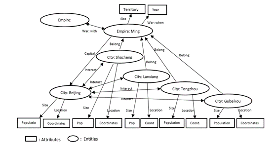
Figure 4: Graph data structure (Data source: Ciolek, OWTRAD)
Figure 4 is an example of a graph data
structure based on entities, attributes and connections among entities.
The SETPOL project will also utilize the
graph-based ontology approaches in Geographic Information Systems such as ArcGIS. The geospatial information of settlements and
polities will be integrated in the GIS domain for constructing cartographic
maps. This will be further structured with a time component in a dynamic
spatiotemporal visualization format, illustrating changes in ten world regions
and the political military and trade networks over time on maps. The constructed maps will be presented on the
SETPOL data archive and made accessible to the collaborating researchers during
the project period and to the public after the project period.
Preservation
and Documentation of data
The
detailed standards, procedures, and protocols of the data collection will be
discussed and determined among PIs and senior advisors at a conference at the beginning
of the research project. The goals of
data collection and data preservation will include the following:
·
Archive population sizes, territorial sizes,
climate change data, geophysical characteristics of polities, coordinates using
the geo URI scheme, polity maps, trade and military network nodes, level of
trade, materials transported between the nodes, warfare, alliances and
diplomacy, and others.
·
Obtain
the consultation of experts for each region to review the data quality and to
help resolve instances in which estimates are found to be inconsistent. Expert
consultants will also carefully review the final data archive. Remaining
disagreements among experts and sources will be included in the final data
archive, including indicators of the quality of estimates based on the level of
consensus among experts. (for experts’ regions, see pages 9 and 10) Change these pages no. to the right page numbers when we
finalize the draft Experts’ region on the above page is not complete
·
Create
a catalog of archived information.
·
Provide
technical assistance to research assistants for the collection of data and data
input based on the collection standards and protocols in science.
To
ensure that the data will be understood and used appropriately by the general
public and scholarly users the data documentation will specify: the data
collection method, data collection context, data structure and organization,
reports on data reliability and validity, and data quality reports (including descriptions
of manipulation of the data that have been conducted). The project data archive will be included in
the data section of the World-Systems Archive ( http://wsarch.ucr.edu/archive/data.html), a publically
available archive that has been housed at the University of
California-Riverside since 2000 CE. It is a secure institutional repository at
UCR that allows access to the academic and public communities. The PI will preserve the database in
accessible and usable form for five years after finalization of the IBSS grant.
Sharing
of data: The
data produced by the SETPOL project will be shared among collaborators in the
data construction stage and with the general public in the final stage. The
SETPOL project collaborates with SESHAT: The Global History Data Bank; the
Collaborative for Historical Information and Analysis, Atmosphere Regolith
Vegetation (ARVE), Collaborative for
Historical Information and Analysis (CHIA) and World History Archives and the
Open History Project.
Data
entry:
The project participants will enter the data in the standardized spreadsheet
format. The spreadsheets are collected
by the data manager of the project to be compiled in the main archive file. The main archive file that is made accessible
to the collaborating researchers on data website in the format of CSV and
graph-based data format.
Data
improvement:
The data will be updated throughout the research period. The data will be added by incorporating newly
published research in the related disciplines as the project proceeds. The collaborators will use the data to test
research hypotheses as the project collects enough data.
Data
adoption:
As the database is finalized, the data archive will be made into an open data
archive online. The final data will be
made available for public and academic use.
Policies
and provisions for re-use, re-distribution, and the production of derivatives: Rights to copy, adapt,
include, distribute, share, reuse, or display the data in other publications
are expected. Public users of this
database are free to adapt the data with attribution of author(s).
REFERENCES
CITED
Abu-Lughod, Janet.
1989. Before European Hegemony: The World System A.D. 1250-1350. New
York: Oxford University Press.
Adams, Robert McCormick.
1981. The
Heartland of Cities: Surveys of Ancient Settlement and Land Use on the Central
Floodplain of the Euphrates. Chicago: University of Chicago Press
Alexandria Digital
Library (ADL) Gazetteer http://www.dlib.org/dlib/january99/hill/01hill.html
Algaze, Guillermo.
1993. The Uruk World System: The Dynamics of Expansion of Early Mesopotamian
Civilization. Chicago: University of Chicago Press.
Allen, Mitchell. 1995. Contested
Peripheries: Philistia in the Neo-Assyrian World-System. Unpublished Ph.D.
Dissertation, UCLA.
Anderson, Eugene. N. 2014. Food and
Environment in Early and Medieval China. Philadelphia, PA:
University of Pennsylvania Press.
Anderson,
Eugene. N. and C. Chase-Dunn. 2005“The Rise and Fall
of Great Powers” in Christopher Chase-Dunn and E.N. Anderson
(eds.) The Historical
Evolution of World-Systems. London: Palgrave.
Bairoch, Paul. 1988.
Cities and Economic Development Chicago: University of Chicago Press.
Beaujard, Philippe.
2005 The Indian Ocean in Eurasian and African World-Systems Before the
Sixteenth Century. Journal of World History 16,4:411-465.
_____. 2009 Les mondes de l’océan Indien Tome
I: De la formation de l’État au premier système-monde Afro-Eurasien (4e
millénaire av. J.-C. – 6e siècle apr. J.-C.). Paris: Armand Colin.
_____. 2010. “From Three possible Iron-Age
World-Systems to a Single Afro Eurasian World-System.” Journal of World
History 21:1(March):1-43.
_____. 2012. Les
mondes de l’océan Indien Tome II:
L’océan Indien, au coeur des globalisations de l’ancien Monde du 7e au
15e siècle. Paris: Armand Colin
Boles, Elson E. 2012.
“Assessing the debate between Abu-Lughod and Wallerstein over the
thirteenth-century origins of the modern world-syste”・Pp. 21-29 in S. J.
Babones and C. Chase-Dunn (eds.) Routledge Handbook of World-Systems
Analysis. New York: Routledge.
Borgatti, S. P.,
Everett, M. G. and Freeman, L. C. 2002 UCINET 6 for Windows: Software for
Social
Network Analysis http://www.analytictech.com.
Brohan, P., R. Allan,
E. Freeman, D. Wheeler, C. Wilkinson, and F. Williamson. 2012.
"Constraining the temperature history of the past millennium using early
instrumental observations" Clim. Past, 8, 1551-1563.
www.clim-past.net/8/1551/2012/
Burton, M.L, C.C. Moore,
J.W.M. Whiting, and A.K. Romney. 1996. "Regions based on Social
Structure." Current Anthropology 37:87-123.
Carneiro, Robert L.
1978 “Political expansion as an expression of the principle of competitive
exclusion,” pp. 205-223 in Ronald Cohen and Elman R. Service (eds.) Origins
of the State: The Anthropology of Political Evolution. Philadelphia:
Institute for the Study of Human Issues.
_____. 2004. “The political
unification of the world: whether, when and how – some speculations.” Cross-Cultural
Research 38 (2):162-177.
Chandler, Tertius.
1987. Four Thousand Years of Urban Growth: An
Historical Census. Lewiston,N.Y.: Edwin Mellon Press.
Chase-Dunn,
C. and Thomas D. Hall. 1997. Rise and Demise: Comparing
World-Systems
Boulder,
CO.: Westview.
Chase-Dunn, C. and Kelly M. Mann.1988. The Wintu and Their
Neighbors:
A Small World-System in Northern California, University of Arizona Press.
Chase-Dunn, C. and Andrew K. Jorgenson.
2003. “Regions and Interaction Networks: an
institutional materialist perspective.” International
Journal of Comparative Sociology 44(1):433-450.
Chase-Dunn,
C., Susan Manning, and Thomas D. Hall, 2000 "Rise and Fall:
East-West Synchronicity and Indic Exceptionalism Reexamined" Social
Science History 24,4: 721-48(Winter).
Chase-Dunn, C. and
Susan Manning, 2002 "City systems and
world-systems: four millennia of city growth and decline," Cross-Cultural
Research 36, 4: 379-398 (November).
Chase-Dunn, C. and Hiroko Inoue.
2011. “Explanations of scale
changes in settlement and polity sizes” IROWS Working Paper # 67
irows.ucr.edu/papers/irows67/irows67.htm
Chase-Dunn,
C and Bruce Lerro.
2014. Social Change: Globalization from the Stone
Age to the
Present. Boulder, CO: Paradigm
Chase-Dunn, C. David Wilkinson, E.N. Anderson, Hiroko Inoue and
Robert Denemark 2015a “Time-
mapping
globalization since the Bronze Age” IROWS Working Paper
# 100 https://irows.ucr.edu/papers/irows100/irows100.htm
Chase-Dunn, C. Hiroko Inoue, Alexis Alvarez,
Rebecca Alvarez, E. N.
Anderson and Teresa Neal 2015b “Uneven Political
Development: Largest Empires in Ten world Regions and the Central
International System since the Late Bronze Age” presented
at the annual conference of the California
Sociological Association, Sacramento, November 13 IROWS Working Paper #85 https://irows.ucr.edu/papers/irows85/irows85.htm
Chew, Sing C. 2001.
World ecological degradation: accumulation,
urbanization, and deforestation, 3000 B.C.-A.D. Walnut Creek, CA:
Altamira Press
_____. 2007. The Recurring Dark Ages:
ecological stress, climate changes, and system transformation
Walnut Creek, CA: Altamira Press
_____.
2014 “The Southeast Asian connection in the first
Eurasian world economy,
200 BC- AD 500” Journal of Globalization Studies,
Vol. 5 No. 1: 82–109
CHGIS: the China
Historical Geographic Information System http://www.fas.harvard.edu/~chgis/index.html
CHIA:
Collaborative for Historical Information and Analysis
http://www.chia.pitt.edu/
Christian,
David. 2004. Maps of Time.
Berkeley: University of California Press.
Ciolek, Matthew n.d.
OWTRAD: Old World Trade Routes Project. http://www.ciolek.com/owtrad.html
Collaborative for
Historical Information and Analysis, University of Pittsburg http://www.chia.pitt.edu/
Collins,
Randall. 1981 “Long term social change and the territorial power of states,”
Pp. 71-106 in R. Collins (ed.) Sociology since Midcentury. New York:
Academic Press.
Collins, Randall. 1992.
“The Geographical and Economic World-Systems of Kinship-Based and
Agrarian-Coercive Societies.” Review 15(3):373-88.
Collins, Randall. 1999.
Macro-History: Essays in Sociology of the Long Run. Stanford: Stanford
University Press.
Daftlogic
n.d. http://www.daftlogic.com/projects-google-maps-area-calculator-tool.htm
Diamond, Jared.
2005. Collapse. New York: Viking
Eckhardt, William. 1992. Civilizations,
Empires and Wars: A Quantitative History of War. Jefferson, NC: McFarland.
Ekholm, Kasja and
Jonathan Friedman. 1982. “Capital Imperialism and Exploitation in the Ancient
World-Systems.” Review 6(1):87-110.
Fagan, Brian. 2005. The Great Warming: Climate Change and the Rise and Fall of
Civilizations. New York:Bloomsbury
Fletcher, Roland.
1995. The Limits of Settlement Growth.
Cambridge: Cambridge University Press.
_____. n.d. City and Polity Data Files, Personal
communication
Frank, Andre Gunder and
Barry Gills. 1994. The World System: 500 or 5000 Years? London:
Routledge.
Frank,
Andre Gunder 1998 Reorient: Global Economy in the Asian Age. Berkeley:
University of
California Press.
_____. 2014 Reorienting the 19th
Century: Global Economy in the Continuing Asian Age. Boulder, CO: Paradigm
Publishers.
Goldstone,
Jack A. 1991 Revolution and Rebellion in the Early Modern World. Berkeley:
University of
California Press
_______________
2009 Why Europe?: the Rise of the West in
World History, 1500-1850. New York:
Mcgraw-Hill
Hawley, Amos. 1950. Human
Ecology: A Theory of Community Structure. New York: Ronald Press Co.
Honeychurch,
William. 2013. “The Nomad as State
Builder: Historical Theory and Material Evidence from Mongolia” Journal of
World Prehistory 26:283–321.
Innis, Harold. 1972
[1950]. Empire and Communications. Toronto: University of Toronto Press.
Inoue, Hiroko, Alexis
Álvarez, Kirk Lawrence, Anthony Roberts, Eugene N Anderson and Christopher
Chase-Dunn. 2012. “Polity scale shifts
in world-systems since the Bronze Age: A comparative inventory of upsweeps and
collapses” International Journal of Comparative Sociology http://cos.sagepub.com/content/53/3/210.full.pdf+html
Inoue, Hiroko, Alexis Álvarez, Eugene N. Anderson, Andrew Owen, Rebecca Álvarez,
Kirk Lawrence and Christopher Chase-Dunn. 2015. “Urban scale shifts since
the Bronze Age: upsweeps, collapses and semiperipheral development” Social
Science History Volume 39 number 2, Summer
Johnson, Allen W. and
Timothy Earle. 1987. The Evolution of Human Societies: From Foraging Group
to Agrarian State. Stanford: Stanford University Press.
Kaplan, Jed.
n.d. PopMap: Population Evolutions with Google Map.
http://arve.unil.ch/popmap/
Kardulias,
P. Nick, ed. 2015. The Ecology
of Pastoralism. Boulder: University Press of Colorado.
Khaldūn, Ibn.
1958. The Muqaddimah. Vol. 1. Tr. and ed. by Franz Rosenthal. New
York: Pantheon Books.
Kirch, Patrick.
1984. The Evolution of Polynesian Chiefdoms.
Cambridge: Cambridge University Press
_____. 1991. “Chiefship and
competitive involution: the Marquesas Islands of Eastern Polynesia”
Pp. 119-145 in Timothy Earle (ed.) Chiefdoms: Power, Economy and Ideology. Cambridge: Cambridge
University Press.
Korotayev, Andrey. 2005. “A
compact macro-model of world-system evolution” Journal of
World-Systems Research.11 (1): 79-93.
Kroeber, Alfred L. 1944 Configurations
of Culture Growth Berkeley: University of California Press
La Lone,
Darrell. 2000. "Rise, Fall, and Semiperipheral
Development in the Andean World-System." Journal of World-Systems
Research 6 (1):68-99. http://jwsr.ucr.edu/index.php
Larsen, Mogens Trolle.
1976. The Old Assyrian City-State and its
Colonies. Copenhagen:
Akademisk Forlag.
Lattimore,
Owen. 1940 Inner Asian Frontiers of China. New York: American
Geographical Society. Boston: Beacon Press.
Lenski, Gerhard.
2005. Ecological-Evolutionary Theory.
Boulder, CO: Paradigm Publishers
Mann, Michael. 1986. The Sources of Social Power
Volume I: A History of Power From the Beginning to A.D. 1760. New York, NY:
Cambridge University Press.
Lewis, Martin W, and
Karen E. Wigen 1997 The Myth of the Continents: A critique of metageography.
Berkeley: University of California Press.
Manning, Patrick. 2013 Big
Data in History, New York: St Andrew’s Press (Palgrave MacMillan)
Lieberman, Victor. 2003. Strange
Parallels: Southeast Asia in Global
Context, c. 800-1830. Vol. 1: Integration on the Mainland. Cambridge:
Cambridge University Press.
_____. 2009. Strange Parallels: Southeast Asia in Global Context, c. 800-1830. Vol 2: Mainland
Mirrors: Europe, Japan, China, South Asia, and the Islands. Cambridge:
Cambridge University Press.
Liverani,
Mario. 2014. The Ancient near East: History, Society and
Economy. London: Routledge.
McAnany, Patricia A.
and Norman Yoffee, Eds. 2010. Questioning Collapse: Human Resilience, Ecological Vulnerability
and the Aftermath of Empire.
Cambridge: Cambridge University
Press.
McIntosh, Roderick J., Joseph A. Tainter and Susan Keech McIntosh
(eds.) 2000. The Way the Wind
Blows: Climate, History and Human Action. New York: Columbia University
Press.
McNeill, J. R. and
William H. McNeill. 2003. The Human Web: A Bird's Eye View of World History.
New York: W. W. Norton.
Melko, Matthew and
Leighton R. Scott (eds.) 1987. The Boundaries of Civilizations in Space and
Time. Lanham, MD: University Press of America.
Meyer, John W. 2009.
World Society. Edited by Georg Krukcken and Gili S. Drori. New York:
Oxford University Press.
Modelski, George.
2003. World Cities: –3000 to 2000. Washington, DC: Faros 2000
Modelski, George and W.
R. Thompson. 1996. Leading sectors and world powers: the coevolution of
global politics and economics. University of South Carolina Press.
_____. Tessaleno Devezas and William R. Thompson
(eds.) 2008
Globalization As Evolutionary Process: Modeling Global
Change. London: Routledge.
Mogens Herman Hansen
(ed.). 2000. A comparative study of thirty city-state cultures: an
investigation. conducted by the
Copenhagen Polis Centre, Det Kongelige Danske Videnskabernes Selskab,
(Historisk-filosofiske skrifter, 21).
Mogens Herman Hansen
(ed.). 2002. A comparative study of six city-state cultures: an
investigation. Det Kongelige Danske Videnskabernes Selskab
(Historisk-filosofiske skrifter, 27).
Mogens Herman Hansen
and Thomas Heine Nielsen (eds.). 2004. An Inventory of Archaic and Classical
Poleis: An Investigation. Conducted by The Copenhagen Polis Centre for the
Danish National Research Foundation. Oxford: Oxford University Press.
Morris, Ian.
2010. Why the West Rules—For Now. New York:
Farrer, Straus and Giroux
_____. 2013. The
Measure of Civilization. Princeton, NJ: Princeton University Press.
Morris, Ian and Walter Scheidel (eds.) The Dynamics of Ancient Empires: State
Power from
Assyria to Byzantium. New York: Oxford University Press.
Nichols, Deborah L,
Thomas. H. Charlton (eds.) 1997. The Archaeology of City-states:
cross-cultural approaches.
Washington: Smithsonian Institution Press.
Open History Project n.d.
Russian Foundation for Basic Research http://openhistory.net/
Ortman, Scott G., Andrew H.
F. Cabaniss, Jennie O. Sturm, and Luı´s M. A. Bettencourt. 2014. "The
Pre-History of Urban Scaling" PLOS ONE. 9 (2) www.plosone.org
Ortman, Scott G. Andrew H.
F. Cabaniss, Jennie O. Sturm and Luís M. A. Bettencourt. 2015. "Settlement
scaling and increasing returns in an ancient society" Science Advances, 1
(2) http://advances.sciencemag.org/content/1/1/e1400066.full
Owens, J.B., Anderson
Sandes, Barbara Stephenson, David Dixon and Catherine Zajanc n.d. A. Geographic
Information Systems (GIS) Training Manual for Historians and Historical Social
Scientists. https://www.academia.edu/8438126/A_Geographic_Information_Systems_GIS_Training_Manual_for_Historians_and_Historical_Social_Scientists
Pasciuti,
Daniel. 2002. “A measurement error
model for Estimating the Population Sizes of Preindustrial Cities” https://irows.ucr.edu/research/citemp/estcit/modpop/modcitpop.htm
Pasciuti, Daniel and
Christopher Chase-Dunn. 2002. “Estimating the
Population Sizes of
Cities” https://irows.ucr.edu/research/citemp/estcit/estcit.htm
Pomeranz,
Kenneth 2000 The Great Divergence: Europe, China and the Making of the
Modern World
Economy. Princeton: Princeton University Press.
Quigley, Carroll. 1961.
The Evolution of Civilizations. Indianapolis: Liberty Press.
Rozman, Gilbert. 1973. Urban Networks in Ching
China and Tokogawa Japan. Princeton, NJ:
Princeton University Press.
SESHAT :
The Global History Data Bank http://seshatdatabank.info/
Scheidel, Walter.
2009. “From the “great convergence” to the “first
great divergence”:
Roman and Qin-Han state formation” Pp. 11-23 in Walter
Scheidel (ed.) Rome and
China: Comparative Perspectives on Ancient World Empires. New York: Oxford
University Press.
_____. ORBIS: The Stanford Geospatial Network Model
of the Roman World
_____. and Sitta Von Reden (eds.) The Ancient
Economy. New York: Routledge.
Sherratt, Andrew
G. 1993a. "What Would a Bronze-Age
World System Look Like? Relations
Between Temperate Europe and the Mediterranean in Later Prehistory." Journal of European Archaeology
1:2:1-57.
_____. 1993b. "Core, Periphery
and Margin: Perspectives on the Bronze
Age." Pp. 335-345 in Development
and Decline in the Mediterranean Bronze Age, edited by C. Mathers and S.
Stoddart. Sheffield: Sheffield Academic Press.
_____. 1993c. "Who are You Calling Peripheral? Dependence and Independence in European
Prehistory." Pp. 245-255 in Trade and Exchange in
Prehistoric Europe, edited by C. Scarre and F. Healy. Oxford:
Oxbow (Prehistoric Society Monograph).
_____. 1993d. "The Growth of
the Mediterranean Economy in the Early First Millennium BC." World Archaeology 24:3:361-78.
Schwartzberg,
Joseph E. (ed) 1992. A Historical Alas of South Asia. Second Impression,
with Additional Material. New York: Oxford University Press.
New York: Oxford
University Press. Digital
South Asia Library, Center for Research Libraries http://dsal.uchicago.edu/reference/schwartzberg/
Skinner, G.
William (ed.) 1977. The City in Late Imperial China
Stanford: Stanford University Press.
Smith, Charlotte Ann.
2002. “Concordant change and core-periphery
dynamics: a synthesis of highland Mesoamerican archaeological data” University
of Georgia, PhD dissertation.
Smith, Michael E. 2005.
“City size in late postclassic Mesoamerica” Journal of Urban History 31,
4: 403-434.
Smith, Michael E. and
Lisa Montiel 2001 “The Archaeological Study of Empires and Imperialism in
Pre-Hispanic Central Mexico” Journal of Anthropological Archaeology 20,
245–284
Smith, Michael E. Gary
M. Feinman, Robert D. Drennan, Timothy
Earle and Ian Morris. 2012.
“Archaeology as a social science” PNAS, 109. 20:
7617–7621 (May 15)
Sturtevant, William C.
General Editor. 1978-2007. Handbook of North American Indians.
Washington, D.C.: Smithonian Institution. http://anthropology.si.edu/handbook.htm
Sutton, Mark Q. and
E.N. Anderson 2014 Introduction to
Cultural Ecology. Lanham, MD: Altamira
Press.
Taagepera, Rein. 1978a. "Size and duration of empires:
systematics of size" Social Science Research. 7:108-27.
_____. 1978b.
"Size and duration of empires: growth-decline curves, 3000 to 600
B.C." Social Science Research, 7:180-96.
_____. 1979.
"Size and duration of empires: growth-decline curves, 600 B.C. to 600
A.D." Social Science History 3 (3-4):115-38.
_____. 1997.
“Expansion and contraction patterns of large polities: context for Russia.” International
Studies Quarterly. 41(3):475-504.
Tainter, Joseph.
1988. The Collapse of Complex Societies. Cambridge: Cambridge University Press.
Teggart, Frederick J.
1939. Rome and China: A Study of Correlations in Historical Events. Berkeley,
CA: University of California Press.
Thompson, William R and
Kentaro Sakuwa 2013 “Was Wealth Really Determined in 8000 BCE, 1000 BCE, 0 CE,
or Even 1500 CE? Another, Simpler Look” Cliodynamics 4,1: 2-29 http://escholarship.org/uc/item/64q20336
Tilly, Charles. 1984. Big
Structures, Large Processes, Huge Comparisons. New York, NY: Russell Sage.
Turchin, Peter.
2003. Historical Dynamics. Princeton, NJ:
Princeton University Press.
_____. 2011. “Warfare and the Evolution of Social
Complexity: a Multilevel Selection Approach” Structure and Dynamics Vol.
4, Iss. 3, Article 2:1 -37
Turchin, Peter. and T.
D. Hall. 2003. Spatial synchrony among and within world-systems: insights from
theoretical ecology. Journal of World Systems Research 9,1 http://csf.colorado.edu/jwsr/archive/vol9/number1/pdf/jwsr-v9n1-turchinhall.pdf
Turchin, Peter and
Sergey Nefadov. 2009. Secular Cycles.
Princeton, NJ: Princeton University Press.
Turchin, Peter, Thomas
E.Currie, Edward A.L. Turner and Sergey Gavrilets 2013 “War, space, and the evolution of Old World complex societies” PNAS
October vol. 110 no. 41: 16384–16389 Appendix: http://www.pnas.org/content/suppl/2013/09/20/1308825110.DCSupplemental/sapp.pdf
United Nations 2011
World Urbanization Prospects: The 2011 Revision: Methodology http://esa.un.org/unpd/wup/pdf/WUP2011_Methodology.pdf
University of Sydney
Timemap Project http://sydney.edu.au/arts/timemap/about/animations.shtml
Wallerstein, Immanuel.
1984. “The three instances of hegemony in the
history of the capitalist world-economy.” Pp. 100-108 in Gerhard Lenski
(ed.) Current Issues and Research in Macrosociology, International
Studies in Sociology and Social Anthropology, Vol. 37. Leiden: E.J. Brill.
_____. 1995. “Hold the tiller firm:
on method and the unit of analysis” Pp. 239-247 in Stephen K. Sanderson (ed.) Civilizations
and World-Systems. Walnut Creek, CA: Altamira Press.
_____. 2011. [1974]. The Modern
World-System I: Capitalist Agriculture and the Origins of the European
World-Economy in the Sixteenth Century. Berkeley: University of California
Press.
White, D. R., Natasa
Kejzar and Laurent Tambayong. 2006. “Oscillatory dynamics
of city-size distributions in world historical systems”. Pp. 190-225 in G.
Modelski, T. Devezas and W. Thompson, (eds.) Globalization as Evolutionary
Process: Modeling, Simulating, and Forecasting Global Change. London:
Routledge.
Wilkinson, David. 1987.
“Central Civilization.” Comparative Civilizations Review 17:31-59.
_____. 1991. “Core, peripheries and
civilizations,”Pp. 113-166 in C. Chase-Dunn and T.D. Hall (eds.) Core/Periphery
Relations in Precapitalist Worlds. Boulder, CO: Westview Press http://www.irows.ucr.edu/cd/books/c-p/chap4.htm
Wilkinson, David.
2003. “Civilizations as Networks: Trade, War, Diplomacy, and Command-Control.”
Complexity Vol.8 No. 1, 82-86 http://eclectic.ss.uci.edu/~drwhite/Complexity/Wilkenson.pdf_____.
_____. 2014. "The
Rise and Demise of (Genuine) Capitalist Imperialism: 13th-16th century Venice,
Genoa and the Hanse" International Studies Association Conference in
2014
_____. 1992a. "Decline phases
in civilizations, regions and oikumenes." A paper presented at the annual
meetings of the International Studies Association, Atlanta, GA. April 1-4.
_____. 1992b. "Cities,
civilizations and oikumenes:I." Comparative Civilizations Review
27:51-87 (Fall).
_____. 1993. “Cities, civilizations
and oikumenes:II” Comparative Civilizations Review 28: 41-72.
_____. 2004. The Power Configuration
Sequence of the Central World System, 1500-700 BC Journal of
World-Systems Research Vol. 10, 3.
Wilkinson, Toby C.,
Susan Sherratt and John Bennet. 2011.
Interweaving Worlds: Systemic Interactions in Eurasia, 7th to 1st
Millennia BC. Oxford: Oxbow Books.
Wissler, Clark. 1927.
“The Culture Area Concept in Social Anthropology.” American Journal of
Sociology 32(6):881-891.
Wohlforth, William C., Richard Little, Stuart J.
Kaufman, David Kang, Charles A Jones, Victoria Tin-Bor
Hui, Arther Eckstein, Daniel Deudney
and William L Brenner. 2007. “Testing balance of
power theory in world history” European Journal of International Relations
13,2: 155-185.
Wong,
R. Bin 1997 China Transformed: Historical Change and the Limits of European
Experience.
Ithaca: Cornell University Press.
World History
Archives: http://www.manning.pitt.edu/activities.html
Wright, Henry T. 2006.
“Atlas of Chiefdoms and Early States” Structure and Dynamics 1,4.
Available at: