Working Paper # 5
Systems of Cities and World-Systems:
Settlement Size Hierarchies and Cycles of Political Centralization, 2000 BC-1988 AD
Christopher Chase-Dunn and Alice Willard
This paper was presented at the
International Studies Association meeting,
March 24-27, 1993, Acapulco.
Abstract:
Cities have long grown, flourished and declined in a larger context in which interactions with other cities have been important. Sometimes cities co-evolve in networks of complementary interaction while in many other cases cities compete and fight with one another such that the success of one means the failure of others. We study changes in city-size hierarchies in eight world-systems in order to understand the causes and consequences of changes in the relative sizes of cities. The eight world-systems examined are Mesopotamian, Egyptian, Mesoamerican, West African, Indic, Far Eastern, Japanese and the Central world-system which eventually engulfed all the others. Do spatially hierarchical city systems correspond with highly exploitative and centralized empires? What are the relationships between urban growth and changes in the city size hierarchies? What are the similarities and differences in the patterns of city development in different world-systems? We discover that the trajectories of change in city size distributions and urban growth and decline sequences are quite similar for the Central and Far Eastern systems and we try to account for these striking simularities.
Version: 3/17/93
A paper presented at the annual meeting of the International Studies Association, Acapulco March 24-27,1993
Table of Contents
Settlement Size Hierarchies
Power and the City Size Distribution
Comparing the Mean SPIs of Different World-Systems
The Mesoamerican World-System
The West African World-System
The Indic World-System
The Far Eastern World-System
The Central World-System
Relative City Sizes and Power Distributions
Urban Growth and Economic Cycles
Far Eastern and Central Synchronicities
A Plausible Account
This is a comparative examination of settlement systems which focusses on the question of the size of settlements relative to one another within a specified region. Our conceptual scope of comparison includes all world-systems small and large, from those composed exclusively of sedentary hunter-gatherers (e.g. Chase-Dunn, Clewett and Sundahl,1982) to the contemporary global system. In principle we follow the broadly comparative approach to world-systems analysis advocated by Chase-Dunn and Hall (1993). But our data base in this paper is limited to those world-systems which had cities of at least 20,000 in population. In the future we would like to extend our analysis of settlement size hierarchies to systems composed of smaller hamlets, villages and towns. Our comparative theorizing presumes such a broader study.
Though we contend that world-system spatial boundaries should reckon the relationship between bulk goods trade networks, political-military interaction networks and prestige goods trade networks (Chase-Dunn and Hall 1993), for the purposes of this paper we will use political-military network boundaries as defined and specified in David Wilkinson's (1987;1992b) study of "civilizations." This is partly convenience and partly conviction. Wilkinson (1992a, 1992b) has already classified the cities we are studying into his civilizations (defined as political-military interaction networks). But Wilkinson has also specified the boundaries of larger "trade ecumenes" -- networks of prestige goods exchange. His research on the growth and decline of cities (Wilkinson 1992a) indicates that city systems exhibit more coherence in terms of growth patterns within political-military networks than in the larger trade ecumenes. Things which are analyzed separately can always be lumped together later if they reveal contemporaneous patterns of change. For these reasons the world-systems we examine here are defined in the same way as Wilkinson's "civilizations" and we adopt and modify his labels for these. Thus we speak of Mesopotamian, Egyptian, Aegean, Mesoamerican, West African, Indic, Far Eastern, and Japanese world-systems. The dates at which these became integrated in to the "Central world-system" are those used by Wilkinson to indicate the beginning of regularized political-military interaction.[1]
All hierarchical intersocietal systems go through sequences of centralization and decentralization of economic, political and social power. Like states, chiefdoms emerged in sets in which chiefly polities interacted and competed with one another, and these "interchiefdom systems" exhibited a pattern of rise and fall in which the territorial and population size of the largest chiefdoms rose and then declined (Sahlins 1972:144-48 ; Mann,1986:Chapter 2; Friedman and Rowlands, 1977).
The dynamics of this sequence in systems composed of chiefdoms, in which power was organized around hierarchical kinship relations, differ in important ways from the dynamics of rise and fall, political centralization and decentralization, which operate in systems composed of true states.[2] Some chiefdoms developed techniques of power which supplemented and went beyond the metaphors of hierarchical kinship. Thus single polities were able to exercise control over larger areas and the interaction networks composed of these larger polities grew larger and more densely interconnected.
The cycle of the rise and fall of states occurs in all known interstate systems. In some the competition among the states takes the form of the rise and fall of hegemonic core powers, a process which we know well in the modern world-system. In others, and more frequently, the cycle of political centralization/decentralization takes the form of the alternation between interstate systems (in which there are a number of competing states within a core region -- these are called "states systems" by Wilkinson) and world-empires in which a single state succeeds in unifying an entire core area by means of conquest (called universal empires or world states by Wilkinson). Wilkinson (1992b:54) provides us with periodizations of states systems and world-states for eleven state-based "civilizations" defined as interactive networks of polities which are fighting and/or cooperating with each other in which there are cities of at least ten thousand people.
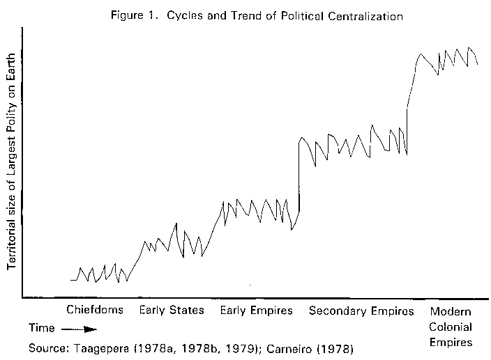
In addition to the cycle of the rise and fall of polities, there is a long run trend toward the increasing size of polities and the decreasing number of autonomous polities on Earth (Carneiro,1978). Rein Taagepera's (1978a,1978b,1979) studies of changes in the territorial size of the largest empires on Earth over the past four thousand years demonstrates the cycles of political centralization and decentralization discussed above. The combination of the long-term trend of increasing size of polities with the medium term process of political centralization/decentralization is illustrated in Figure 1. Taagepera's studies show that the size of largest empire on Earth oscillated up and down for long periods and then jumped up in rapid rises that correspond to the wide conquests by semiperipheral marcher states who created empires across whole core regions. Well-known examples are the Akkadian Empire, the Assyrian Empire, the Alexandrian conquests and the Roman Empire. Figure 1 is a simplified and idealized model based on Taagepera's studies of the territorial size of the largest states and empires and Carneiro's (1978) discussion of the long-term evolutionary trend from many small polities to few large ones.
In this paper we will examine the relationship between the processes of political centralization/decentralization and changes in the relative population sizes of cities located within interacting political/military networks -- Wilkinson's civilizations. The simplest hypothesis is that city systems will become more hierarchical -- that is the largest cities will be much larger than other cities in the same network -- when political/military power is more centralized. This is based on the idea that political power is an important component of the ability of large cities to gather the resources necessary to sustain large populations.
The phenomenon of urban primacy -- the concentration of population in a very large central city with only much smaller cities in the same region -- has been extensively studied in national societies in the modern world-system (Chase-Dunn, 1985a;1985b). It is well-know that France has a very primate city-size distribution, as do most peripheral and semiperipheral countries in the modern world-system. Urban primacy is seen as a problem by many contemporary urban and regional planners and they have constructed and tried to implement policies for encouraging the growth of small and middle-sized cities (rather than further increasing the size of the largest city in a country). There is some literature about settlement systems and city-size hierarchies in premodern city systems (e.g. Kowalewski, 1982; Lightfoot and Feinman, 1982; Nissen, 1988:41) but there are no broad comparative studies which compare city size distributions across world-systems over very long periods of time.
This paper is a contribution to the comparative study of world historical systems over long periods of time. David Wilkinson (1992a;1992b) has recently contributed two studies which utilize data on cities to examine growth and decline in civilizations. Our study continues this effort by using data on the populations of cities and the relative population sizes of cities within regions defined as networks of political-military interaction. We study the relationship between changes in the distribution of city sizes, the growth and decline of the largest cities, the rise and decline of centralized polities, and hypothesized long cycles of political/economic expansion and contraction. Gills and Frank (1991) and Frank (forthcoming) have periodized the history of what we call the "Central world-system" into phases of expansion and contraction. Wilkinson (1992a) has examined the relationship between the periodizations proposed by Gills and Frank with changes in the city systems. He used data from Chandler's (1987) compilation of city populations, Four Thousand Years of Urban Growth, to study the sizes and number of the largest cities in both political/military interaction networks and larger trade networks ("oikumenes"). Wilkinson found some support for the expansion/contraction periodization proposed by Gills and Frank. We will use the population data in a somewhat different way to examine the Gills-Frank periodizations and we will compare changes in city size hierarchies with Wilkinson's periodization of civilizations in to states systems and world-states. Our study extends world historical comparative research by adding the variable of changes in city size hierarchies and by constructing a different measure of urban growth.
Settlement Size Hierarchies
What do we mean by city size hierarchy? All human settlements interact with other settlements. The size of individual settlements can be studied as they grow or decrease, and the relative size of settlements can also be studied. This means looking at the distribution of settlement sizes within a region. Some regions contain settlement systems which are very hierarchical in the sense that there is a single very large settlement which is surrounded by very small settlements. Such settlements systems are called "primate" because there is a single center which is much larger than any other settlement. Geographers have developed theories which suggest that a "normal" settlement size hierarchy will correspond to the rank-size rule in which the second largest settlement is half the size of the largest, the third largest is one-third the size of the largest, the fourth largest is one-fourth the size of the largest and so on. The rank-size rule is also called the "log normal" rule because the distribution of settlement sizes approximates a straight line when the settlement sizes are logarithmically transformed. Some settlement systems are "flat" in the sense that the towns or cities or villages of which they are composed are all about the same size. So we can discuss different settlement systems as primate, rank-size or flat depending upon the relative size of the settlements of which they are composed. The size hierarchy aspect allows us to compare very different kinds of settlement systems to one another because we are looking at the relative, rather than the absolute, sizes of settlements. Thus a system composed of villages can be just as hierarchical as a system composed of great cities if one village is much larger than the others.
In order to make such relative comparisons a statistic called the Standardized Primacy Index was developed by Walters (1985). The Standardized Primacy Index (SPI) takes a value of zero when a settlement size distribution corresponds to the rank-size rule. It takes on negative values when the distribution is less hierarchical (flatter) than the rank-size rule and positive values when the distribution is more hierarchical than the rank-size rule (primacy). Though the measures of urban populations are subject to error, and to greater error as we go back in time, the degree of error is reduced when we calculate the SPI.
Power and the City Size Distribution
Why should a city system have a steeper city size distribution when there is a greater degree of concentration of power? The simple answer is that large settlements and especially large cities require greater concentrations of resources to support their large populations. This is why population size has itself been suggested as an indicator of power (Taagepera, 1978a:111). But these resources may be obtainable locally and the settlement size hierarchy may simply correspond to the distribution of ecologically determined resources. In a desert environment populations cluster near oases. It is not the political or economic power of the central settlement over surrounding areas which produces a centralized settlement system but rather the ecological distribution of necessary or desirable resources. In many systems, however, we have reason to believe that relations of power, domination and exploitation do affect the distribution of human populations in space. Many large cities are as large as they are because they are able to draw upon far-flung regions for food and raw materials. If a city is able to use political/military power or economic power to acquire resources from surrounding cities it will be able to support a larger population than the dominated cities can, and this should produce a hierarchical city size distribution.
Of course the effect can also go the other way. Some cities can dominate others because they have larger populations. Great population size makes possible the assembly of large armies or navies, and this may be an important factor creating or reinforcing steep city size distributions.
In this paper our main task is to examine the extent to which changes in the degree of population size hierarchies in city systems correspond or do not correspond with changes in the degree of political centralization. We shall also examine the relationship between the SPI index and a measure of urban population in the three largest cities. We also want to examine the hypothesized expansion/stagnation phases proposed by Gills and Frank (1991) and Frank (forthcoming) by observing changes in the size of the urban population. For information about political centralization we will use several sources dealing with historical changes in the relationship among states in each world-system.
As stated above, the primary unit of analysis in our study is the political/military interaction network as constructed by Wilkinson. We have used Chandler's (1987) data on city populations [3] to construct series of SPI indices showing the steepness of city size distributions for eight world-systems: Egyptian in 1600 BC, Mesopotamian in 2000 and 1600 BC; Aegean in 1360 BC; Mesoamerican in 200 BC, 500 AD and 800 AD; West African in 1350 AD, 1500 AD and 1550 AD; Indic from 430 BC to 1550 AD; Far Eastern from 650 BC to 1825 AD; Japanese from 1575 AD to 1850 AD and the Central world-system from 1360 BC to 1988 AD (see Table 1). The Central system incorporated the other world-systems after the dates at which we cease to calculate their SPIs. We have produced SPIs for time points at which we have estimated populations for at least the three largest cities. We used at least three, but a maximum of five, cities when populations for these were available. The SPI is standardized to correct for changes in the number of cities across time points.
Table 1: Standardized Primacy Indices (SPIs) for the five largest cities
in each Political/Military Network
| Year | Egyptian | Mesopotamian | Aegean | Mexican | West
African |
Indic | East Asian | Japanese | Central |
| 2000 BCE | -0.10 | ||||||||
| 1600 BCE | 0.31 | -0.19 | |||||||
| 1360 BCE | -2.05 | -0.21 | |||||||
| 1200 BCE | -2.2 | ||||||||
| 650 BCE | -0.72 | -0.21 | |||||||
| 430 BCE | -0.32 | -0.09 | -071 | ||||||
| 200 BCE | -2.36 | 0.20 | 0.20 | -0.40 | |||||
| 100 CE | -1.21 | 0.25 | -0.15 | ||||||
| 361 CE | -0.22 | -0.52 | 0.62 | ||||||
| 500 CE | 0.10 | -1.96 | -0.30 | -0.64 | |||||
| 622 CE | -0.82 | 0.02 | 0.19 | ||||||
| 800 CE | -0.87 | -1.99 | 0.11 | 0.12 | |||||
| 900 CE | -1.70 | 0.18 | 0.11 | ||||||
| 1000 CE | -1.79 | 0.03 | -0.09 | ||||||
| 1100 CE | -0.60 | 1.67 | -1.67 | ||||||
| 1150 CE | -1.47 | -3.91 | -2.87 | ||||||
| 1200 CE | -2.05 | -0.68 | -2.44 | ||||||
| 1250 CE | -1.71 | -0.23 | -0.28 | ||||||
| 1300 CE | -2.58 | -0.46 | -0.04 | ||||||
| 1350 CE | -2.5 | -1.04 | -0.46 | -0.07 | |||||
| 1400 CE | 0.27 | -0.21 | -0.30 | ||||||
| 1450 CE | 0.11 | 0.02 | -0.13 | ||||||
| 1500 CE | -2.5 | 0.04 | 0.07 | -0.26 | |||||
| 1550 CE | -010 | 0.19 | 0.05 | -0.03 | |||||
| 1575 CE | 0.06 | 0.24 | -0.06 | ||||||
| 1600 CE | 0.04 | -0.29 | -0.15 | ||||||
| 1650 CE | -0.12 | -0.73 | -0.62 | ||||||
| 1700 CE | 0.01 | 0.17 | -1.09 | ||||||
| 1750 CE | 0.02 | -0.20 | -1.20 | ||||||
| 1800 CE | -0.13 | -0.19 | -0.47 | ||||||
| 1825 CE | -0.07 | 0.12 | -0.15 | ||||||
| 1850 CE | 0.08 | -0.34 | |||||||
| 1875 CE | -0.04 | ||||||||
| 1900 CE | -0.22 | ||||||||
| 1914 CE | -0.82 | ||||||||
| 1925 CE | -1.51 | ||||||||
| 1950 CE | -0.50 | ||||||||
| 1970 CE | -0.85 | ||||||||
| 1988 CE | -0.94 | ||||||||
| Mean | 0.31 | -0.15 | -2.05 | -1.04 | -1.70 | -0.98 | -0.18 | -0.10 | -0.59 |
| Standard
Deviation |
-- | 0.05 | -- | 1.01 | 1.13 | 0.90 | 0.84 | 0.30 | 0.72 |
Observe in Table 1 that the SPI for the Mesopotamian regional world-system was -0.1 in 2000 B.C. The negative sign means that the Mesopotamian city size hierarchy was flatter than the rank-size rule. In 1600 B.C. the Mesopotamian SPI was -0.19 and so the city size hierarchy had become a bit flatter than it had been in 2000. Appendix A contains the city lists and population estimates that we have used to construct our measures. The first table in Appendix A shows the largest cities and their population sizes (in thousands) for the Mesopotamian world-system in 2000 B.C. Appendix A is located at gopher://csf.Colorado.EDU:70/11/wsystems/datasets/citypop/civilizations.
We have interpolated the population sizes of some cities in Chandler's lists by the following method. We have used Chandler's (1987:460-510) tables of the world's largest cities at each time point. These lists rank all the cities above a certain size and give populations for some of them. For the ones not given populations by Chandler we estimated the populations by assuming equal intervals between the cities on the list. So if we know that the second city has 50,000 and the fifth city has 20,000 we interpolate the third city as 40,000 and the fourth city as 30,000. The cities for which populations are given by Chandler are marked in Appendix A with an asterisk (*). For those not so marked the populations have been interpolated. Note that the interpolations were done using Chandler's lists, which include cities from all over the world, not our lists which include only those cities in each world-system.
The first list in Appendix A shows the Mesopotamian cities in 2000 BC. The largest, Ur, had a population of 65,000 while the second largest, Lagash had 37,000 and the third city, Susa, had 25,000. Mari and Nippur are at 24 and 23 thousand. This produces an SPI of -0.1, rather close to the rank size rule. Remember that if the rank size rule had described the distribution exactly the SPI would have been zero. Now let us look back again at Table 1.
At the bottom of the table are the average SPIs for each of the political/military networks. The grand mean for all the SPIs in the Table is -0.820. Thus the average city size distribution for all the political/military networks for which we have data tends to be flatter than the rank-size rule. An earlier study of city size distributions in modern national societies showed that these are, on the average, steeper than the rank-size rule (Chase-Dunn, 1985b). But modern national societies are parts of a larger intersocietal system, not whole systems unto themselves. An earlier study of the Europe-centered modern world-system as bounded by the Braudel Center scholars (Chase-Dunn, 1985a) showed that this larger intersocietal system composed of multiple states has city size distributions which are usually flatter than the rank-size rule over the period from AD 800 to 1975. Intersocietal systems composed of multiple states are much more likely to have relatively flatter city size distributions than are single states precisely because political power is more decentralized relative to the relations among cities in these larger systems than it is in single states.
Certainly the way in which we bound the regions within which we study city systems is important for what we find. In principle we want to study cities that are engaging in important interactions with one another. If we include within the same region cities which are not connected to one another either directly, or indirectly but in consequential ways, by human interactions such as trade, warfare, and communications, we are lumping together in our analysis things which were not importantly connected in reality. Thus we could consider the entire Earth as a single region since 2000 B.C. and analyze all the known cities as part of a single system since then (as seems to be suggested by the approach developed by Gills and Frank (1991). But this would be a mistake because we know, for example, that Mesoamerican cities were not linked to Old World interaction networks in any important way until the sixteenth century A.D. Lumping them in to the Central world-system before then would be a mistake.
Comparing The Mean SPIs of Different World-Systems
Notice at the bottom of Table 1 that the mean SPIs for the different world-systems are quite different from one another. Though the data points are few, it is interesting to note that the Mesopotamian world-system has a flatter city size distribution than does the Egyptian world-system. This is consistent with what we know about differences between the Egyptian and Mesopotamian political systems. In Egypt a centralized empire formed very early and was relatively stable for a long time, producing a more hierarchical city system. In Mesopotamia a number of city-states emerged and interacted within a larger inter-city-state system for a long while before the unification of the Mesopotamian core by the Akkadian conquest. And that early empire was not long-lived. The Mesopotamian city size hierarchy is flatter than the Egyptian one, and we are tempted to say that this is due to the differences in political structure between the two regions.
Comparing the average SPIs across the different world-systems at the bottom of Table 1 we can note some other interesting differences. The average of all the SPIs in Table 1 is -0.820 and the average for the Central world-system (-0.59). The Egyptian, Mesopotamian, Aegean, Mesoamerican and West African world-systems do not have enough SPIs for us to venture generalizations about them.
The Indic world-system shows an average SPI of -0.981 based on 19 time points. This is flatter than the average for the Central world-system and the difference is [is not] statistically significant. The Far Eastern world-system has an average SPI of -0.184 based on 27 time points. This is more hierarchical than is the average for the Central world-system and this difference is [is not] statistically significant. In this case a city system which is more hierarchical corresponds to what many have perceived as a relatively more centralized political system. John Fitzpatrick (1992) has recently emphasized that Chinese development before the Mongol conquest occurred in the context of a competitive interstate system in which geopolitical competition among states often played an important part in shaping outcomes. Fitzpatrick contends that in this respect Chinese development was more similar to that in the European regional system than most of the many contrasters of Chinese empire and European state system would admit. This approach to the Far Eastern world-system is further strengthened by Thomas Barfield's (1989) work on the systemic relations between Chinese and steppe nomad states. While we may agree with Fitzpatrick's overall point, the difference in the average degree of city size hierarchy between China and the Central world-system may indicate that political centralization was greater, on the average, in China. But since the relationship between political centralization and urban size hierarchy is the hypothesis we are investigating, it would be premature to come to this conclusion at this point.
The Japanese world-system was even more hierarchical on the average than was Far Eastern, with a mean SPI of -0.100 based on eight time points. This is quite close to the rank-size rule and the difference between the means of the Japanese and Central world-systems is [is not] statistically significant. It might be thought that the relatively hierarchical shape of the Japanese city system is due to the fact that Japan is rather small and small regions are more likely to have hierarchical city-size distributions. Studies of city size distributions in modern national societies show a negative correlation between the territorial size of a country and the degree of hierarchy of the city size distribution. Obviously Hong Kong and Singapore, city-states, are urban primate, but this correlation holds even when such cases are omitted. Does size account for the relatively more hierarchical average SPI in the Japanese world-system? Well it might account for some of it, but it can not account for all of it. Though four of the eight individual SPIs in Japan are more hierarchical than the rank size rule, the SPI for 1650 A.D. is -0.733, which is flatter than the average of all the SPIs in Table 1. Since the territorial size of the Japanese world-system did not change between 1600 and 1700, the less hierarchical city size distribution cannot be due to size of the region. If urban hierarchy can be shown to be a reflection of political centralization, the city size data for Japan will contradict the notion that Japan was a decentralized feudal system between 1575 and 1850.
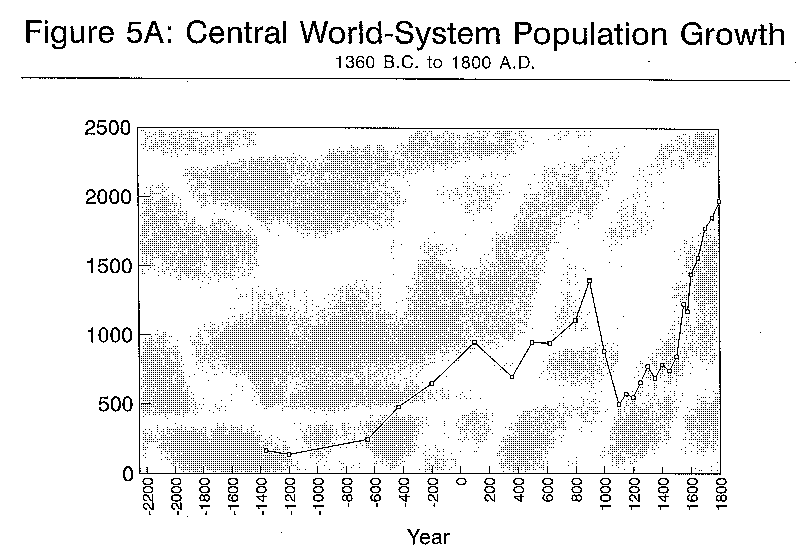
Though these differences between average SPIs across world-systems suggest some support for the notion that city size hierarchies are correlated with regionally centralized political power, our main analysis of the relationship between city size hierarchies and periods of political centralization/decentralization requires the comparison of SPIs over time within world-systems. Inspection of the standard deviations of the distributions of SPIs for each world-system in the bottom row of Table 1 shows that there are big differences over time in all the world-systems for which we have several time points. We have plotted the changes in SPIs for each world-system for which we have several time points and now we will proceed to compare the changes in the SPIs over time with information we have about the rise and fall of states and empires. Table 2 shows the total urban population in the three largest cities in each Political/Military Network. These numbers show the growth of urban populations in each PMN but not the relative size of the cities as the does the SPI. The urban populations in Table 2 are the numbers that are graphed in Figures 2A, 3A, 5A and 6A below.
Table 2: Total Urban Population (thousands) in the three largest cities
in each Political/Military Network
| Year | Egyptian | Mesopotamian | Aegean | Mexican | West
African |
Indic | East Asian | Japanese | Central |
| 2000 BCE | 127 | ||||||||
| 1600 BCE | 144 | 122 | |||||||
| 1360 BCE | 82 | 165 | |||||||
| 1200 BCE | 138 | ||||||||
| 650 BCE | 193 | 245 | |||||||
| 430 BCE | 202 | 355 | 480 | ||||||
| 200 BCE | 101 | 512 | 554 | 650 | |||||
| 100 CE | 334 | 596 | 950 | ||||||
| 361 CE | 302 | 350 | 700 | ||||||
| 500 CE | 215 | 225 | 445 | 950 | |||||
| 622 CE | 260 | 700 | 944 | ||||||
| 800 CE | 144 | 224 | 1000 | 1110 | |||||
| 900 CE | 260 | 740 | 1400 | ||||||
| 1000 CE | 260 | 690 | 885 | ||||||
| 1100 CE | 330 | 667 | 500 | ||||||
| 1150 CE | 352 | 445 | 575 | ||||||
| 1200 CE | 207 | 585 | 550 | ||||||
| 1250 CE | 270 | 640 | 660 | ||||||
| 1300 CE | 290 | 983 | 778 | ||||||
| 1350 CE | 170 | 315 | 982 | 690 | |||||
| 1400 CE | 565 | 872 | 790 | ||||||
| 1450 CE | 705 | 1025 | 745 | ||||||
| 1500 CE | 170 | 840 | 1072 | 850 | |||||
| 1550 CE | 190 | 710 | 1132 | 1230 | |||||
| 1575 CE | 1154 | 465 | 1175 | ||||||
| 1600 CE | 1170 | 760 | 1445 | ||||||
| 1650 CE | 951 | 1236 | 1565 | ||||||
| 1700 CE | 1153 | 1418 | 1780 | ||||||
| 1750 CE | 1640 | 1469 | 1857 | ||||||
| 1800 CE | 2287 | 1445 | 1978 | ||||||
| 1825 CE | 2660 | 1432 | 2865 | ||||||
| 1850 CE | 1423 | 5282 | |||||||
| 1875 CE | 8391 | ||||||||
| 1900 CE | 14052 | ||||||||
| 1914 CE | 18119 | ||||||||
| 1925 CE | 20816 | ||||||||
| 1950 CE | 28323 | ||||||||
| 1970 CE | 49702 | ||||||||
| 1988 CE | 65500 | ||||||||
| Mean | 144 | 125 | 82 | 153 | 177 | 377 | 963 | 1206 | 6455 |
The Mesoamerican World-System
We have only three SPIs for Mesoamerica and they are widely spread apart in time. In 200 BC the Mesoamerican city size distribution was very flat. By 500 AD the city system had become more hierarchical than the rank-size rule and this was due to the rise of the massive and famous Teotihuacan. Teotihuacan's destruction in about 700 AD resulted in a city system which was again quite flat in 800 AD Unfortunately we are limited to archaeological evidence regarding the political changes which were occurring in Mesoamerica in this period and so our ability to either support or contradict the proposition that changes in the city size hierarchy were related to changes in the structure of political power is limited. Many scholars simply assume the verity of the proposition we are trying to evaluate -- that changes in the relative sizes of cities correspond to changes in the loci and concentration of power. Thus Wilkinson (1991:129-31) and Blanton, Feinman and Kowalewski (1992) give us interpretations of changes in the power of various centers in Mesoamerica, but these interpretations are primarily based on archaeological estimates of the sizes of cities. This assumes the proposition we are trying to test. We have more independent information about the politics of Mesoamerica in later times, but the Chandler data does not contain enough cities to enable us to compute SPIs. In future work we intend to supplement Chandler's data from other sources in order to further study the Mesoamerican city system. The Mesoamerican world-system was engulfed by the Central world-system in the early sixteenth century AD.
The West African World-System
As with the Mesoamerican system, there were relatively few data points for the the West African world-system. However, the three listed in Table 1 (1350, 1500 and 1550 AD) are considerably less hierarchical than is generally the case for present-day sub-Saharan Africa. These time periods reflect two primary empires in the bend of the Niger. The first of these data points (1350 AD) corresponds with the peak of the Mali empire. The years 1500 and 1550 correspond with major political shifts in the Songhai empire. Wilkinson (1991:132) says of the West African civilization "...it makes somewhat more sense to speak of a slow and fairly steady eastward drift." This is accurate in the broadest sense, but this was due to the changing patterns of trade and alliances throughout the entire Sahara. The relative city sizes may be somewhat deceptive, as the historical and archaeological records do not correspond. What is particularly interesting about the Chandler data is the indication of a shift toward a more hierarchical city size distribution between 1500 and 1550. This roughly corresponds to the overthrow of Sosonis by the Askias and may have set the stage for the successful invasion by the Moroccans in 1591, as it presented a single tempting target rather than several smaller ones.
The Indic World-System
Figure 2 displays changes in the SPI of the Indic world-system from 430 BC to 1550 AD. This figure demonstrates a long cycle of variation between rank-size city hierarchies and very flat distributions in which the five largest cities in India were all about the same size. In 200 BC the Indic city system was rather hierarchical with an SPI of 0.20. It became less hierarchical in a jerky decline until it bottomed out between 500 and 800 AD. Then it moved again in the direction of a size hierarchy until 1100 AD and then declined again to its flattest point in 1300 AD. It then rapidly became hierarchical once more, climbing to an SPI of 0.273 in 1400 AD and it stayed near that level until 1550. Wilkinson is ambivalent about whether the Indic political/military network was incorporated into Central "Civilization" with the Islamic invasions of the late tenth century or later as a result of the European incursions into India (Wilkinson, 1992b:86; 1991:128). Perhaps the best we can do is to say that it was partially incorporated, became somewhat autonomous again, and then was more strongly incorporated.
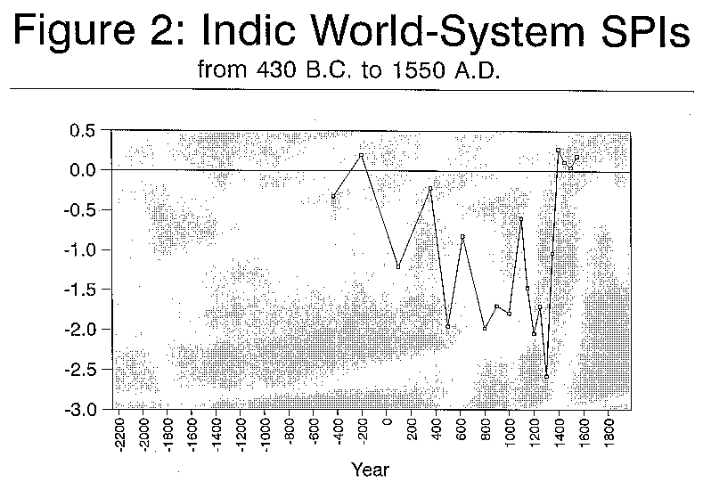
The early rise and fall of urban hierarchy between 430 BC and 100 AD, corresponds with the period which Wilkinson (1991:118) designates as the only time in which a world-state exists in Indic civilization, the Mauryan empire from 262 to 231 BC. Before and after the Mauryan empire Wilkinson designates the existence of a states system. But this states system alternated between phases in which a single state, usually in the valley of the Ganges, held hegemonic power and phases in which power was much more widely spread among contending states (Wilkinson, 1991:127-8). The dates at which we have data on city populations are often too far apart to correspond exactly with the known dates of political changes. Thus, for example, the Mauryan empire was established in 262 BC and fell in 231 BC but we have city population data for 430 BC and 200 BC. In principle the Mauryan empire had been gone for thirty years by the time we get our snapshot of the Indic city system. Of course Chandler's population estimates are based on information which is only roughly near the designated time points, especially for these early periods.
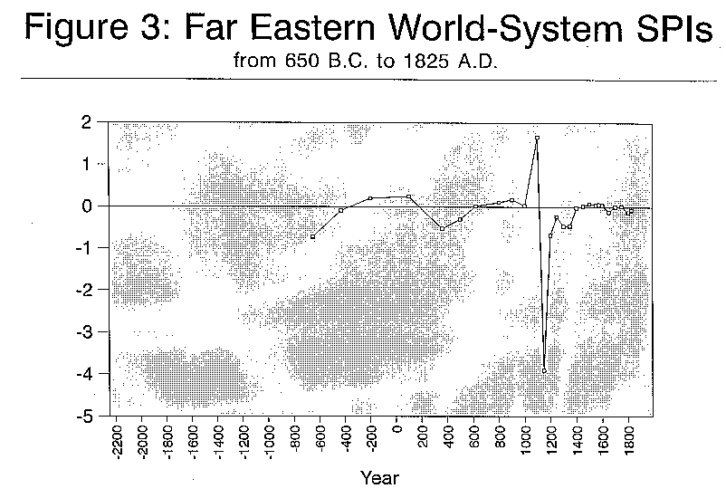
Patna, the empire city of the conqueror state of Mauryan Magahda, was quite the primate city in BC 200. According to Chandler the population of Patna was 350,000 in the year 200, while the second largest city, Ujjain, had a population of only 94,000 (see Appendix A). This degree of urban hierarchy is not to exist again in India for another 1600 years. Thus Wilkinson's designation of this period as a universal state supports the idea of an association between urban hierarchy and political centralization. This is a good point to bring in the discussion of urban population size, which is different from the degree of hierarchy or flatness of a city size distribution. Urban population size is simply the sum of the populations of the largest cities in a region. It differs from the concept of "urbanization," which is the proportion of the total population in a region that lives cities. We have no measures of the total population size of the world-systems we are studying so we cannot compute measures of urbanization, but we can compute measures of the urban population size by simply adding the populations of the largest cities together. We have chosen to use the populations of the three largest cities because this allows us to determine the urban population size for all the time points at which we have SPIs. We have also examined an urban size measure based on the sum of the five largest cities at each time point for which we have five cities. The three-city and five-city urban size indices are rather highly correlated with one another. [how highly?] The urban size measure shows how big the big cities in a region are and changes show growth or decline in the overall urban populations. Remember that the Standardized Primacy Index shows the relative size of cities in a region to one another and the SPI is standardized to take out the effects of overall size so that we can compare regions composed of very large cities with regions which have only small cities, or even towns or villages.
Figure 2A graphs the urban population size index for the Indic world-system over the same period for which we have SPIs. If you compare the graph of SPIs in Figure 2 with the graph of urban populations in Figure 2a you will see that the two patterns of change are similar in some ways and different in others. The pattern of SPI change is much more erratic. But the long-term swings are similar for both city size distribution and urban population size. Indic urban population rises rapidly from 430 to 200 BC and then declines until 500 AD it then oscillates up and down a bit until 1000 AD, climbs until 1150, drops precipitously to a very low point in 1200, recovers somewhat until 1350 and then zooms up to its highest point in 1500 and drops back a bit in 1550. The correlation [how big is the correlation?] between changes in the city size distribution and in the overall size of the urban population is not a statistical artifact because the two measures are independent of one another due to the standardization of the SPI. This correlation requires a substantive interpretation.
Back to the Indic SPI and its relationship with what we know about changes in the geopolitics of India. The SPI declines from 0.2 in 200 BC to -1.21 in AD 100. Wilkinson (1991:128) mentions that "A brief Kushana empire was established in the north (upper Ganges and Indus basins) by Kanishka at Peshawar c. AD 78-100 incidentally reforming an Indic core." But the Chandler data for 100 AD shows Peshawar to have been the second largest city with a population of 120,000. Slightly larger was Anuradhapura with 130,000. Anuradhapura had been the third largest city 200 BC with a population of 68,000. The low SPI of AD 100 does not correspond well with the notion that this was a period of empire. But the empire of which Wilkinson speaks was only in the north. Anurahapura was far away on the southern tip of the subcontinent.
Wilkinson (1991:128) mentions that the Gupta empire reestablished the dominance of Patna from 330 to 500 A.D. In this case the Chandler data fits better. At 361 AD we have Patna the largest city with 150,000 and a fairly hierarchical SPI of -0.22. By 500 Patna had disappeared from the list and the SPI plunged to -1.96. [4] Then Wilkinson (1991:128) reports that a "Gangetic empire was founded by Harsha at Kanuaj 606-647, reconstituting a core." In 622 we have Kanauj as the largest city with 120,000 and a somewhat more hierarchical SPI of -0.82 . Wilkinson continues, "Then once more a dispersal: Kanauj, Gurjara-Pratihara, Pala, Rashtrakuta, Rajputs, Sind, Chola, Pallava, Chalukya, Vengi, Pandya, Ceylon, Chandella, Paramara, Yaminis of Ghazni." This period of dispersal corresponds to the long period in which there was a very flat city size distribution from 800 AD to 1000 AD. The names mentioned by Wilkinson are, with the exception of Kanauj, the names of states, not cities. Patna reappeared as the second largest city in 800 and the SPI is a very flat at -1.986. Of AD 800 Wilkinson says, "Vatsaraja and Nagabhata II led the rise of the Gurjara-Pratihara dynasty in northern India; Pallavas, Rashtrakutas, Gangas, Chalukyas, Pandyas struggle in the south." (Wilkinson, 1992b:81-2). For the 900 AD cities list we follow Wilkinson (1992b:83) in substituting Vengipura for Bhimavarman in Chandler's list. This very flat distribution continued until 1000 AD when, Wilkinson reports, Mahmud of Ghazni was attacking India. In 1100 AD a new hierarchy emerged with the first Muslim invasions and the SPI is -0.595. 1150 is the high point of an expansion of urban population which had been rising since 800.
Then the urban population plummeted by 1200 to a point close to what it had been in BC 400. Of the five largest cities in 1150 only the fifth largest, Puri, was still on the list in 1200. Polonnaruwa moved from ninth largest with a population of 50,000 in 1150 to the number one spot with a population of 75,000 in 1200. Wilkinson (1991:128) says of the period between the 11th century and the eighteenth century that it "continued the alternation of north Indian core empires with states-system chaos...." Our data show a flattening of the city size distribution to its lowest point in 1300 AD, but the urban population was headed up already between 1200 and 1300 and it continued to rise until 1500. The thirteenth century was a period of heightened urbanization in South India according to Janel Abu-Lughod (1989:282). She attributes this partly to "the healthy position of textile manufacture and the growing international demand for this product." The city size distribution rose rapidly to its steepest point in the fourteenth century. In 1400 AD the SPI was 0.273 and it remained quite hierarchical until 1550 AD, the last point at which we have data for the Indic system. In the second half of the fourteenth century the Delhi empire began to break up. Delhi itself was sacked by Tamerlane in 1398 and its riches were hauled off to Samarkand (Abu-Lughod, 1989:283). The new city size hierarchy is due to the decline of all the northern cities and the rapid rise of Vijayanagar in the South to a population of 400,000 in 1400. Vijayanagar was the capital of a new Hindu state that conquered widely across the South of the subcontinent.
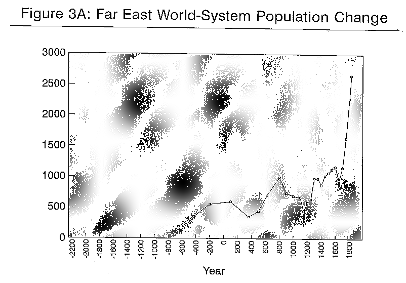
The Far Eastern World-System
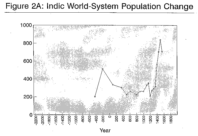
Our data series for the Far Eastern world-system [5] runs from 1650 BC to 1825 AD when it was finally incorporated in to the political/military web of the Central world-system by the gunboat diplomacy of the United Kingdom. Figure 3 shows the overall picture regarding changes in the city size distribution in the Far East. The China-centered system exhibits a fairly rank-size distribution of city sizes except for the years 1100 AD and 1150 AD. In 1100 AD the system peaked at its most hierarchical point with an SPI of 1.667. Fifty years later, in 1150 it plunged to its lowest point with the flattest distribution in all our calculations, an SPI of -3.906. These massive changes mask the more subtle but still significant smaller variations in the city size distributions in other periods. We need to examine these smaller variations in connection with what is known about changes in the distribution of power in the Far Eastern world-system.
Wilkinson (1991:117-19) designates Far Eastern "civilization" as having three long periods in which there was a world-state. The first such period was the Ch'in-Han dynasties from 221 BC to AD 184. The second was the Sui-Tang dynasties from AD 589 to 750, and the third was the Mongol-Ming-Manchu dynasties from AD 1279 through 1850. Before, and in between, the world-states were periods which Wilkinson designates as states systems. These broad characterizations of the Far Eastern geopolitical system correspond fairly well to the changes we see in the SPIs. The Ch'in-Han dynasties correspond to the early peak period of city size hierarchy in 200 BC and AD 100. The Sui-Tang dynasties correspond fairly well with a second period from 622 AD to 900 AD during which the SPI was more hierarchical than the rank size rule. After the huge upswing and downswing of 1100 and 1150 the city system recovered to a level of hierarchy which is typical for world-systems. It wobbled about a bit before moving up to the rank size rule in 1400 where it stayed until 1825. These last movements correspond fairly well with Wilkinson's classification of a world-state from 1279 on.
Now let us look more closely. In 650 BC the SPI was -0.72, quite flat. There was a new largest city, Lintzu, and it was quite a bit larger (at 80,000) than the former largest city, Sian, has been in 1000 BC. Loyang still held second place. Wilkinson (1992b:69) says "In the Yellow River basin the Eastern Chou 'dynasty' presides over a loose confederacy of states.... Lintzu was the capital of Chi, a state (and people) at this time semi-barbarian, i.e. not yet culturally assimilated to, nor accepted as of, what we may call 'Chinese' culture."
In 430 BC the SPI has moved decisively in the direction of the rank size rule at -0.08 and the urban population also shows a major increase. The largest city, Yenhsiatu (in the north not far from where Peking is now), is new to the list and had a large population of 180,000. Loyang was still second, but larger at 100,000, Lintzu was now fifth and had gone down to a population of 60,000. Of this time Wilkinson (1992b:70) says, "In the Yellow River plain, power continues to diffuse to the increasingly warring states." Wilkinson's characterization does not seem to fit the urban population increase or the city size distribution changes which, according to the Chandler data, occurred in this period. The conquests of the Ch'in state, completed in 221 BC do not account for the hierarchical city system in 430 BC when Ch'in was a growing, but still small, state (Elvin 1973:25). What else besides conquest could account for the emergence of an interregional city size hierarchy in China during the warring states period? [6]
A number of important changes were going on in this period. The hundreds of smaller states were merging, through conquest, into larger states (Elvin,1973:26). The economy was becoming more monetized, land was commodified, transportation was developed and interregional economic interdependence and trade were increasing and some areas were developing specialized industrial products (Hsu,1965:107-126). The growth of cities in this period is described by Hsu (1965:134-8) as follows:
In 200 BC the city size hierarchy had become even more steep and Changan was the largest city with a population of 400,000. The urban population continued to rise. No mystery here. This was the first Chinese empire, consolidated in 221 through the conquests of the Ch'in state (Elvin, 1973:25). In 100 AD we see that the urban hierarchy was still steep (SPI = .25) but now the largest city was Loyang, the Later Han capital, with 420,000. The urban population had continued to grow but not at the same rate.
In 361 AD both the urban population and the city size hierarchy had fallen. The largest city, Nanking, had only 150,000 and the second city was Ye with 120,000. Loyang, the former empire city, disappeared from the list. It was sacked in A.D. 311 by the son of Liu Yuan, the founder of the steppe-nomad Hsiung-nu dynasty. The time of troubles began with peasant uprisings and formidable challenges from semiperipheral border states in the second century. Elvin (1973:35) says,
In 500 AD Loyang had reappeared as the largest city with a population of 200,000, still less than half the size it had in 100 AD. The total urban population had begun to recover but had not yet reached the level it had in BC 200. The city size distribution had begun to move back toward the rank size rule but the SPI was yet only -.296. The "Toba" state in the North was a creation of the steppe nomads but it was well on the road from a "dynasty of conquest to a bureaucratic empire" by 500 AD (Elvin,1973:47). The Sinification of the invaders and the restoration of political stability made possible the restoration of production, markets and cities. Loyang grew large again because the Toba state moved its capital there in AD 494 (Elvin,1973:51).
In 622 AD we find a fully restored city size hierarchy with an SPI of .02, a bit steeper than the rank size rule. The urban population was now higher than its former high point in 100 AD. The largest city was once again Changan which had attained the size it had 822 years before in 200 BC -- 400,000 people. This was the middle empire. Wilkinson (1991:133) says, "A new politico-military power emerges in the northwest under Sino-nomad elites and states, and under the Sui and T'ang states creates first a core empire and then a universal state encompassing the bulk of the semiperiphery as well as the core." The Sui dynasty built long canals in the first decade of the seventh century linking the breadbasket of the Yangtze River valley to the political-military heartland in the north (Elvin,1973:55).
In 800 AD we find an even steeper city system (SPI=0.109) and an urban population which had grown to its highest point so far and one which it would not attain again for another 500 years. Changan had grown to 600,000 and Loyang was number two with 300,000. The Tang dynasty was already experiencing difficulties but it did not fall until 906. Says Elvin (1973:65),
In 1100 AD we find the most hierarchical city system of all the ones that are included in Table 1. The SPI is 1.667. This represents a massive increase in the steepness of the city size distribution between 1000 and 1100 AD. On the other hand the total urban population was very near what it had been 100 years before, so the city system became more hierarchical by redistributing population among the largest cities. Kaifeng had grown to 442,000 (up from 400,000) but Angkor, the number 2 city had decreased its population from 200,000 (in 1000 AD) to 125,000.
What explains this major rearrangement of the urban population and the quick emergence of a steep urban hierarchy? The Northern Sung dynasty lasted until 1126. Elvin (1973:69) ascribed the ability of the Sung to reunite China to an economic and technological revolution which "reduced the burden of the imperial administrative superstructure, increase the efficiency of the Chinese war machine, and created enough economic integration to be a real obstacle to renewed political fragmentation." His analysis of this period focusses primarily on the creation of a manorial economy in which peasants were enserfed by landlords, though it is unclear why this would have solved the problems of empire. Elvin's own analysis of the period just previous argued that extreme exploitation of the peasantry was a process which eventually undermined the central government by provoking rebellions.
This is a key juncture in Chinese history which, as Elvin argues, is the point at which the Far Eastern and West Asian systems began to diverge. The key difference, he argues, is the structure of the state. Both East and West developed a manorial economy based on serfdom, but the in the West political power devolved to the feudal lords while in the East a central state was able to survive and to keep reasserting itself despite repeated conquests by steppe nomads and northern woodsmen. Elvin's main argument for why this was possible points to the sophistication of Chinese agriculture and trade.
The industrial production of the Sung dynasty is legendary, and a great proportion of this was devoted to the production of military armaments, and this was concentrated in the capital, Kaifeng. Ma (1971: Chapter 5) argues that this is a major factor in the rapid growth of Kaifeng and thus it would account for the extremely primate city size distribution we see in 1100. This was accomplished by concentrating resources and population in the capital city at the expense of the other large cities.
In 1127 the Chin Tartars took Kaifeng and conquered Northern China. [7] The city data we have for the year 1150 shows the results of this barbarian conquest. The SPI index for 1150 is -3.906, In fifty years the Far Eastern world-system went from the most hierarchical to the flattest city size distribution of all the distributions we have studied. Kaifeng went from 442,000 to 150,000, while Pagan, a city in the south, grew from 100,000 to 150,000 probably due to a large influx of refugees from the north. Hangchow, the Southern Sung capital, also grew from 90,000 to 145,000. Angkor and Nanking had 140,000 and 130,000 respectively. Thus in 1150 there were five cities of nearly the same size in China. The total urban population had dropped in this fifty year period.
The city data for 1200 shows a system in which the urban hierarchy had partially recovered and the total urban population was growing again, though it had not yet recovered to its level of 1100. The SPI is now -0.677. The largest city was now Hangchow, capital of the Southern Sung dynasty, with a population of 255,000. Pagan now had 180,000. A newly emergent city in the north, Peking, made the top five for the first time with a population of 130,000. Kaifeng was not among the top five and had continued to lose population since 1150.
The city data in 1250 show a continuation of the same trends. The size hierarchy continued to recover, as did the total urban population. Hangchow now had 320,000 and Peking was third with 140,000. A massive epidemic further reduced Kaifeng after the lifting of the Mongol siege in 1232 (Elvin,1973:175).
The Southern Sung dynasty lasted until 1275 when it was conquered by the Mongols. The Mongols first overran the Chin Tartars in the North and then conquered all of China. The city data for 1300 show the effects of the Mongol conquest but these were not nearly as massive as the effects of the Chin Tartar conquest of the north. The SPI becomes a bit more flat at -0.461 but this is a far cry from the plunge it took with the fall of Kaifeng to the Chin. And the total urban population continued to rise. Both Hangchow and Peking grew substantially and the main reason that the city size hierarchy got flatter is because Peking nearly caught up with Hangchow. Of the top five cities in 1250 only one, Angkor, lost population in the period of the Mongol conquest.
We may wonder why the Chin conquest had so dramatically flattened the city size hierarchy and reduced the urban population while the Mongol conquest did not. Barfield (1989:197-202) describes the Mongol conquest of the North as particularly destructive because the Chin regime resisted heartily. Barfield also argues that the Chinggis Khan was quite ambivalent about taking state power the agricultural heartland. Chinggis had intended to extort riches from the Chin state -- the outer frontier strategy -- but was forced to conquer because the Chin refused to pay. Says Barfield (1989:205) "For thirty years after the conquerors death, his descendants clung to the belief that the empire could be centered aroung their steppe city/encampment at Karakorum, which for that short time was the political power center of Eurasia." Yet the Mongol Yuan dynasty was already constructing new canals by 1292 (Chi, 1963:140). The steppe-oriented policy quickly shifted to a new focus on China with the reign of of Khubilai, who moved the capital to Peking and consolidated a bureaucratic state. The conquest of the south was taken with more care to not destroy the vital resources of the agrarian state. Perhaps this is the reason that the cities rebounded quickly.
Between 1300 and 1350 the city populations barely changed at all. This period is noteworthy for its lack of change. Yet this was a period in which the Mongol empire in China disintegrated and was replaced by a number of independent states. It was also a period in which the Black Death swept across the Chinese south (Abu-Lughod, 1989:172). It is the resilience of Chinese cities which is the remarkable feature of this period.
In 1368 the strongest of the smaller states, centered in Nanking, absorbed the rest and established the Ming dynasty. The city data in 1400 shows that Nanking was the number one city with a population of 487,000. The SPI (-0.021) had again begun to move upward toward the rank size rule. But the overall urban population was down just a bit from its level in 1350, again showing that the distribution can become steeper while the level declines. Hangchow, now in second place had declined to a population of 235,000. Canton and Peking were tied for third with populations of 150,000.
The city size distribution was now restored what we may consider its normal degree of hierarchy, one that was approximated from 622 to 1000 AD and that now returned and would last until the incorporation of the Far Eastern into the Central world-system in the nineteenth century. The period from 1100 to 1350 will be understood as a temporary deviation from what we now see to have been normal for an interregional city size hierarchy in China. In this period of disruption the hierarchy became abnormally steep and then it plunged to the ridiculously flat, and then it moved to what was still an abnormally flat distribution from 1200 to 1350. The Ming restoration was also the restoration of the city size hierarchy.
By 1450 Peking had become the capital and the largest city with a population of 600,000. The Grand Canal had been built in 1411, allowing even better transportation between the south and the north. The SPI had moved to a point a little steeper than the rank size rule but the change was not large. Hangchow had grown slightly. Nanking had declined to 150,000 and was now fourth. Seoul was the fifth largest city in the Far Eastern world-system with a population of 125,000. The overall urban population had grown to a new high point.
In 1500 Peking had grown to 672,000 and the SPI had gotten just a bit steeper. The urban population continued to rise but Hangchow had not grown. Elvin (1973:105) contends that the Ming military and supply systems were experiencing difficulties in the late fifteenth century. He argues that "The soldiers, who were meant to serve on a hereditary basis, were deserting in great numbers, a development which should probably be linked to the decline of serfdom and serflike tenancy." Canton, the third city, declined from 175,000 in 1450 to 150,000 in 1500. Nanking had also decreased, but not much. In 1550 and 1575 Peking continued to grow and so did several of the other cities and also the overall urban population.
But in 1600 Peking did not increase and the overall urban population increased only slightly. The Ming dynasty was experiencing difficulties with maintaining its transport system because of "defaulting, malpractice and theft (Elvin,1973:105-6). And there was a major epidemic in 1588 which killed millions of people in the densely populated areas of China (Elvin,1973:310).
The Ming dynasty fell to the Manchus in 1644. The city data for 1650 show a dip in both the SPI (-0.122) and the urban population. Peking declined from 706,000 to 470,000 and Nanking also lost population. But Hangchow and Canton grew a bit. Seoul again appears in the list as the fifth city. In addition to the disruptions occurring from the Manchu conquest there was another major epidemic, the worst year of which was 1642 (Elvin,1973:310). Elvin contends that the Ming dynasty fell by accident. There was a shortage of military manpower because of the epidemic and the Manchu challenge happened to coincide with a significant internal rebellion. Many of the generals who led the Manchu armies were Chinese (Elvin, 1973:106).
In 1700 the SPI had recovered back to the rank size rule and the urban population had grown nearly back to what it had been in 1575. Peking was now at 650,000 and Hangchow at 303,000. Sian had grown and moved in to fourth place. According to Elvin the Ch'ing dynasty continued to grow primarily by intensifying the logistic mechanisms already developed by the Ming. Serfdom disappeared in China and the local markets developed further.
In 1750 we find that the SPI is about the same and the urban population has jumped up to a new historical high and is headed toward the stratosphere. Peking had 900,000, Canton 400,000. In 1800 the SPI has become a little flatter but the change is small. The urban population has continued to spurt up. Peking had 1,100,000 and Canton was now number two with 800,000, double its size 100 years before. Soochow had moved in to fourth position. In 1825, the last year we consider the Far Eastern world-system to be outside of the Central world-system, the SPI had not changed much but the cities had continued their rapid growth. Peking was at 1,350,00 and Canton had a population of 900,000. Elvin (1973:177) summarizes his discussion of Chinese urbanization so:
The Central World-System
Now let us take a look at the world-system which grew to encompass all other world-systems. [8] It emerged with the "coupling" (Wilkinson) of the Mesopotamian and Egyptian systems in the sixteenth century BC. It is Central that is the focus of study when we teach about the "rise of the West" or "Occidental Civilization." It is the "cutting edge" of historical development in the hands of Michael Mann (1986). It is the World-System in the hands of Gills and Frank (1991), though they define it more broadly in terms of trade links, and so the Eurasian continent is understood to be a single system much earlier than when the criterion of political-military interaction is used. This is also the kind of link stressed by Janet Abu-Lughod (1989) in her study of the thirteenth century world-system, and in Jane Schneider's (1991) early discussion of a single Eurasian "pre-capitalist world-system." David Wilkinson's (1992b) "oikumene" specifies the boundaries of trade interlinkages which preceded the boundaries of the smaller political-military nets.
We do not want to prejudge the issue of which kind of network is most systemic despite our use of political-military networks as our unit of analysis. If the larger trade oikumene is importantly interactive and systemic we should be able to see simultaneities in the developmental patterns of Central, Indic and Far Eastern world-systems. But before we consider that let us take a tour through the sequence of urban growth and city size distribution change for the Central world-system of the kind we have just presented for the Far East.
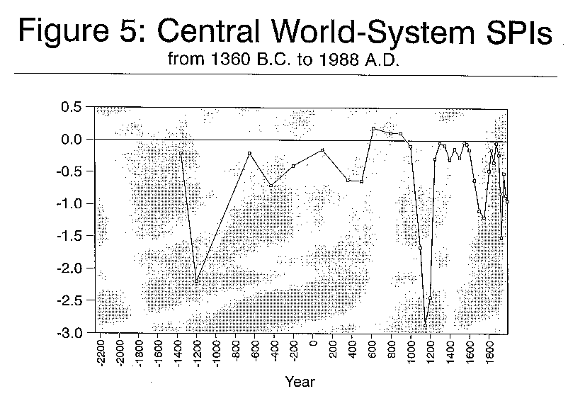
Figure 5 shows the movement of the SPI for the Central system from 1360 BC to 1988 AD. The first thing that we notice is that the movement of this indicator of the steepness/flatness of the distribution of populations among the five largest cities is more erratic than that of the Far Eastern system and that it is usually below the rank size rule designated by the horizontal line showing an SPI of zero. Wilkinson (1991:118) specifies three periods in which the Central system had a world state: the Neo-Assyrian Empire from 663-652 BC, the Persian-Macedonian Empires from 525 to 316 BC, and the Roman Empire from 20 BC to AD 235. Looking at Figure 5 we can see that in 650 BC the SPI is at a peak of hierarchy near the rank size rule, this corresponding nicely with the Neo-Assyrian Empire. But in 430 BC, the only time point we have that corresponds with the Persian-Macedonian world state, the SPI reveals a city size distribution which is moderately flat, a bit flatter than the mean SPI for all the Central system time points. For the Roman world state we have only one SPI at 100 AD and it is quite near the rank size rule. So the score is two out of three. Now let us look more closely at each of the times for which we have city data.
Our first SPI for the Central world-system is for the year 1360 BC. Recall that the average SPI for the Central world-system is -0.590 so it is flatter on the average than the Far Eastern system. The first SPI is -0.21, which is not far from the rank size rule. Wilkinson dates the coupling of the Mesopotamian and Egyptian systems at 1500 BC. [9] In 1360 the largest city was Thebes with a population of 80,000. Number two was Khattushash, the capital of the Hittite empire with 45,000. Third place is held by Dur-Kurigalzu, the capital of Kassite Babylonia with 40,000. Fourth place is held by Memphis and fifth by Amarna. Of 1360 Wilkinson (1992b:62-3) says,
In 1200 BC the SPI had plunged to -2.2, a very flat distribution the likes of which would not be found again for 23 centuries. Memphis is now the largest city with 50,000. Thebes, which was number one in 1360,has dropped to fourth place with a shrunken population of 37,000. Khattushash is second and Dur-Kuigalzu is third. Nineveh holds fifth place. The overall urban population has declined a bit since 1360, this despite Frank's (forthcoming) contention that 1600-1200 BC was a phase of expansion (see Figure 5a).
Of 1200 BC Wilkinson (1992b:65) says, "the Middle Assyrian empire is in decline; Kassite Babylonia has recovered its independence. Egyptian Dynasty XIX has collapsed into an interregnum between two Sea People invasions. The Hittite Empire has collapsed under Sea People attacks, driving refugees into northern Syria where they set up city-states." It is not a pretty picture.
We do not have enough city population data to calculate another SPI until 550 years later, in 650 BC. In this year the SPI again displays a hierarchy, though not a steep one. The SPI is -0.21, the same as it had been in 1360 BC. The urban population had increased and the largest city, Nineveh, the Assyrian capital, had a population of 120,000 and had grown from a population of about 39,000 in 800 BC. We estimate that Memphis had a population of 65,000 and Babylon had 60,000. Jerusalem and Marib, a city at the mouth of the Red Sea, are tied for the number five position with 45,000.
Of 650 BC Wilkinson(1992b:69 says,
The Assyrian empire fell in 612. Of 430 BC Wilkinson (1992b:70-1) says,
In 200 BC the city size distribution had again moved back in the direction of a hierarchy, but not a very steep one. The SPI is -0.4. Urban growth had continued since 430, though not at the pace set from 650 to 430. We cannot evaluate Frank's cycles because he includes both an expansion and a stagnation phase between our data points.
Alexandria was now the largest city with 300,000, followed by Seleucia (founded in 312) with 200,000; both Carthage and Rome had 150,000, and Antioch was the fifth city with 120,000. The empire of Alexander the Great had come and gone, trifurcating into a balance of power between three large Hellenic states. Wilkinson (1992b:72) says of 200 BC,
The next data point we have is 100 AD. The city system continued its trend toward greater steepness, now with an SPI of -0.15. The urban population continued to increase at about the same rate that it did between 430 and 200 BC. This supports Frank's (forthcoming) contention that there was a phase of expansion between 200/100 BC and 200 AD. Rome was the largest city, with 450,000. Seleucia and Alexandria were tied for second with 250,000. Antioch had 150,000 and Carthage 100,000. Wilkinson's (1992b:74-5) synopsis of 100 AD goes, "Rome is nearing its imperial peak under Trajan. Parthia has been quiet since Tiridates received his crown from Nero in AD 63." This was a peak of both the urban population and the city size hierarchy. The weight of the population of the largest cities shifted temporarily westward.
In AD 361 the SPI became flatter at -0.62 and the urban population declined significantly. This supports the Gills and Frank characterization of 150/200 to 500 AD as a stagnation phase. The largest city was now Constantinople (founded in 330) with 300,000, considerably smaller than Rome had been in 100 AD (450,000). Ctesiphon was number two in 361 with 250,000 and Rome and Antioch were tied for third with 150,000. Alexandria was the fifth city with 125,000. Wilkinson (1992b:77-8) reports, "Rome, under Julian, is at war with Sassinid Persia under Shapur II." Ctesiphon was the capital of Sassinid Persia. With the declining size of Rome and the rise of Constantinople the weight of the urban population has moved "back East." The Sassinid empire had taken the Parthian capital of Ctesiphon in 224.
In 500 AD the SPI was almost the same as it had been in 361 but the city size distribution had changed shape. This is one of the dangers of packing a lot of information into a single number like the SPI. In 500 AD we have a situation which can be described as "two-city primacy." Two large cities, Constantinople and Ctesiphon were tied for first place with populations of 400,000. The SPI is -0.636, very near to the figure of -0.62 which we found in 361. The third city was Antioch with 150,000; Carthage, Rome and Alexandria were tied for fourth place with 100,000 each. The two largest cities, Constantinople and Ctesiphon, are the capitals of the two most powerful states -- the Byzantine empire and the Sassinid empire. This is a system which international relations scholars might characterize as "bipolar," but the Byzantine empire contained four of the six largest cities in the Central system in 500 BC (Constantinople, Antioch, Carthage, Alexandria and Rome). Says Wilkinson (1993b:78), "The major central states are Eastern "Rome" under Anastasius I, Sassinid Persia (Zamasp), Ostrogothic Italy (Theodoric the Great), the Frankish lands (Clovis), Visigothic Spain, Vandal Africa." The total urban population grew between 361 and 500, reaching the exact point at which it had been in 100 AD. This contradicts the Gills/Frank hypothesis of a contraction phase between 150/200 and 500 AD.
In 622 AD we find the most hierarchical city size distribution in the history of the Central system. The SPI jumped to 0.19. Ctesiphon now had 500,000 and Constantinople had fallen to 350,000. Much smaller was Alexandria with 94,000, Aleppo with 72,000 and Rayy with 68,000. Rome now had 50,000. In 900 AD it would have 40,000 and then it would disappear from Chandler's table until 1550 when it reappeared with a population of 58,000. The ruins of empire became the foraging grounds of swine.
Of 622 Wilkinson (1992b:80) observes, "The Byzantines under Herclius are attacking the Persians under Chosroes II; neither side takes note of the Hegira." The situation of 500 BC was reversed. Now Ctesiphon was much larger than Constantinople, which had lost population, as had the other large city within the Byzantine empire, Alexandria. Byzantine Aleppo and Sassinid Rayy had grown, though they were still not very large. In terms of the weight of urban population the Sassinids gained while the Byzantines declined in the period since 500 AD. It is this which accounts for the hierarchical city size distribution. But the total urban population in the whole Central system declined slightly since 500 AD. So much for the Gills/Frank designation of a growth phase from 500 to 750/800 BC.
In 800 AD the city size distribution was still hierarchical with an SPI of 0.115. The largest city was now Baghdad (founded in 762 by Mansur) with a population of 700,000 in 800. Constantinople was still second but with only 250,000. Then we had Cordova with 160,000 and three cities with 100,000 each: Basra, Fostat and Rayy. Ctesiphon was taken and plundered by the Arabs in 637. Wilkinson (1992b:81) reports that, "Harun al-Rashad is Abbasid Caliph." Baghdad, the Shiite Abbasid capital, is only 20 miles up the Tigris from the site of Ctesiphon. Cordova was the capital of the surviving Umayyads, founders of the Western caliphate. The total urban population was again rising, this supporting the Gills/Frank hypothesis of an expansion phase between 500 and 750/800 but this was largely due to the growth of the largest city, Baghdad.
In 900 AD the city size distribution was still hierarchical. Baghdad had grown to 900,000 despite the fact that the Abbasid capital was transferred to Samarra in 836, but back to Baghdad in 892. Constantinople had grown to 300,000 and Cordova to 200,000. Alexandria and Fostat in Egypt had also grown. The urban population jumped up at a much more rapid rate in the ninth century, its most rapid rise before the geometric ascent which began in the sixteenth century (see Figure 5a). Unfortunately Gills and Frank have classified the period from 750/800 to 1000/1050 as a stagnation phase. Wilkinson (1992b:83) says, "Leo VI rules at Byzantium, struggling with Bulgarians under Tsar Symeon. Caliph Al-Mu'tadid struggles with the Carmathians."
In 1000 AD the city size distribution had begun its descent to the record-breaking flatness of 1150, but it had not yet gone far. The SPI was -0.089. Cordova was now the largest city with 450,000. It grew from 250,000 in 900. Constantinople is second with the same population it had in 900 AD, 300,000. Cairo (founded in 969 by the Fatamid general, Jauhar Al Rumi) had 135,000 and Baghdad (at 125,000) was now tied for fourth place with Nishapur. Wilkinson's (1992b:84) comment is, "Otto III is Holy Roman Emperor, Basil II is struggling with Tsar Samuel of Bulgaria. Mahmud of Ghazni is attacking India."
The urban population plunged in the tenth century. Its rate of descent was unique but the level it descended to was exceeded in the following century. This supports the Gills/Frank contention that 750/800 to 1000/1050 was a phase of contraction. The main reason for the fall of total urban population was Baghdad's decline from 900,000 in AD 900 to 125,000 in AD 1000. This was a result of the political disintegration of the Abassid caliphate by regional and internal revolts.
In 1100 AD the city size distribution of the Central world-system was extremely flat (SPI= -1.667), but not as flat as it was to become in 1150 AD. Cordova, which had been number one in 1000 had fallen off the list to a population 60,000. This was the consequence of the fall of the Umayyad caliphate and the subjection of Cordova to Seville. In 1100 the largest city was once again Constantinople but with a population of only 200,000. The number two position was shared by Marrakesh, Baghdad, and Cairo each with 150,000. The fifth city was Fez with 125,000.
Marrakesh and Fez and Meknes in Almoravid Morocco represent a new region of large urban centers which sprang up in the twelfth century. Cordova, the first city in 1000, had lost population and moved far down the list by 1100, but Seville gained and was now in sixth place. The total urban population continued to drop, now reaching its lowest level since 430 BC. From this low point it would slowly begin to rise again in the next century. The continued drop between 1000 and 1100 is evidence against the Gills/Frank contention that 1000/1050 to 1250/1300 period was expansionary. Several of the cities did grow, but the fall of Cordova and the declining population of Constantinople outweighed these. Wilkinson (1992b:86) says, "Henry IV is Holy Roman Emperor, Alexius I Comnenus Byzantine. The Seljuk Turk empire is beginning to dissolve."
In 1150 AD we find the city size distribution at the bottom of its descent into extreme flatness. Perhaps this should be called "two-city flatness" because the two largest cities were Merv and Constantinople with 200,000 each. Merv, in central Asia, was the capital of the Seljuk Turk empire from 1118 to 1157. The third city was Cairo with 175,000 followed by Fez and Marrakesh. Baghdad was now ninth. The urban population had begun to rise, but slowly. The remarkable thing about this lowest point in the city size distribution is that it occurred centuries before the great well-known "external shocks" -- the Mongol invasion and the Black Death.
In 1200 the city size distribution was still quite flat and the urban population had fallen a bit. It was still well below the level it had in 1000. The two largest cities in 1200 were Fez and Cairo with 200,000 each, followed by Constantinople, Palermo and Marrakesh. Saladin ended the Fatimid rule of Egypt in 1171 and established the Ayyubid dynasty.
In 1250 we find the city size distribution jumping up to a hierarchy with an SPI of -0.283. The largest city was Cairo with 300,000. Second was Fez with 200,000 and then Paris with 160,000. Then there was Marrakesh and Constantinople. Constantinople had been taken by the army of the Fourth Crusade in 1204 and had declined from 150,000 to 100,000. The urban population was continuing to grow but it had still not yet reached its former level in 1000 AD.
In 1300 we find Cairo still in first place but with a larger population of 400,000.The Mamluks had taken over during the 1250s and successfully stopped the Mongol conquest of Syria and Palestine (Abu-Lughod, 1989:148). Paris was second and had grown to 228,000. Then we have Fez with 150,000, Tabriz with 125,000 and Venice with 110,000. The SPI (-0.04) continued its movement toward greater hierarchy, nearly reaching the rank size rule. The urban population had grown again. In 1350 the SPI had gotten just a bit less steep but was still close to the rank size rule. Cairo was still the largest city but had dropped to 350,000. The Black Death had struck in 1348. Paris was still second with 215,000, down slightly. Fez was third, then Sarai and the Tabriz. The urban population had declined a bit since 1300 but was still higher than it had been in 1250.
In 1400 the SPI had fallen a bit flatter to -0.295. Cairo was still the largest city and had grown to 360,000. Paris was still second and had grown to 280,000. Tabriz was now third with 150,000, up by 50,000 since 1350. Fourth place was held by Samarkand with 130,000, followed by Fez with 125,000. The urban population had grown. In 1450 Cairo was still first with 380,000. Tabriz was second with 200,000. Granada was third with 165,000, and Paris was now fourth with 150,000, down abruptly from 1400. The fifth was Bursa with 130,000. The SPI (-0.13) had become more hierarchical once again. The last period of contraction designated by Gills and Frank, from 1250/1300 to 1450 AD, contained two ups and two downs in total urban population and it ended with urban population being nearly what it was at the beginning.
In 1500 we find that the SPI (-0.26) has fallen a bit flatter again, but not by much. Cairo had grown to 400,000 and Tabriz to 250,000. Constantinople was third with 200,000 despite the fact that it had been depopulated when it fell to the Ottoman Turks in 1453. Paris was fourth with 185,000. Fifth place was held by Fez. Urban population had grown once again, nearly attaining the level it had in 1000 AD. In 1550 the SPI was once again nearly approximating the rank size rule at -0.026. Ottoman Constantinople was once again the largest city with a population of 660,000. Cairo was now second with 360,000, down 40,000 since 1500. Paris was growing again with 210,000. Naples was in fifth place with 209,000. Urban growth reached its highest point since 900 AD. In 1575 things had not changed much. The SPI was just a bit flatter. Constantinople had grown to 680,000 but Cairo had lost population to 275,000. Paris had grown just a bit, as had Naples. The Indic system was now united with Central and the fifth largest city was Agra (eventual home of the Taj Mahal) with 200,000. Total urban population had lost a bit since 1550.
In 1600 Constantinople was at 700,000. The second largest city was Agra with 500,000. Paris was still third with 245,000. Naples was fourth with 224,000. And Cairo had dropped to fifth with 200,000. The SPI had become a bit more flat and was headed toward even more flatness. The urban population had grown rapidly and was now into its permanent geometric ascent. In 1650 Constantinople was still first but it had not grown since 1600. Agra was gone. Paris was second with 455,000, up abruptly in fifty years. London was third with 410,000. In 1600 it had a population of 187,000. Fourth place was held by Lahore with 360,000 and fifth was Isfahan with 350,000. The SPI (-0.6150) had dropped toward flatness, but was on its way to much greater flatness.
In 1700 we find that Constantinople was still first but with the same 700,000 it had in 1600. Second place was now held by London with 550,000. Paris had continued to grow, now having 530,000. Fourth place was now held by Ahmedabad with 380,000 and fifth was Isfahan with 350,000. Sixth place was held by Amsterdam with 210,000. The SPI was now at a rather flat point (-1.093). In 1750 London was the largest city with a population of 676,000. Constantinople was now second with 625,000, down from its former 700,000. Paris was third with 556,000 and Naples was fourth with 310,000. Fifth place was held by Amsterdam with 219,000. The SPI was now at its flattest point in this cycle at -1.196. The flatness was due to the rapid rise of the Western European capitals to the size attained by the cities of the Near East. The multicentric geopolitical structure of the Central system accounts for its difference in this period from the more constant size hierarchy which existed in Far Eastern. In Western Europe the two great powers, Britain and France were leaders of coalitions of European core states about to engage in a military struggle for control over territories in North America and India, the Seven Years War (1756-63).
By 1800 a new city size hierarchy was beginning to emerge but the distribution was still rather flat. The SPI was -0.468. London had grown to 861,000. The second city was still Constantinople. It had continued to fall in population and was now 570,000. Paris was still in third place but had decreased slightly to 547,000. Naples had 430,000 and Moscow was now fifth with 248,000. The Napoleonic wars were about to begin. The tale of two cities, of which we know so much, leaves out Constantinople, still a major player despite its being classified by Immanuel Wallerstein as outside the "modern world-system" because of its non-capitalist mode of production.
In 1825 SPI had moved further toward hierarchy at -0.148. London's population was now 1,335,000. This was a very big city, but it was still smaller than Peking. The second largest city in the Central world-system was now Paris with 855,000. Constantinople was third with 675,000, up considerably from 1800. St. Petersburg now held the fourth position with 438,000. Fifth was Naples with 350,000. The British hegemony was well under way and was reflected in the city size hierarchy of the Central world-system.
In 1850 the SPI dropped temporarily back toward flatness because of the merging of the Far Eastern with Central political-military networks (SPI = -0.335). London continued to shoot up and now had a population of 2,320,000. It was the megacity of the Earth. Peking, the second largest city in the Central (now global) system, had also continued to grow, but not nearly as fast as London. It had a population of 1,648,000. Paris had also grown and was now at 1,314,000. Canton was now in fourth place with 875,000 and New York was fifth with 645,000. The amazing thing about the 1850 city size distribution is that the drop toward flatness was not greater. Two massive urbanized city systems were combined in to one and yet the rapid growth of London still resulted in a size hierarchy of cities.
By 1875 the hierarchy had moved nearly to the rank size rule (-0.039) and this was its most hierarchical point since 1550 AD and it has not returned to this degree of hierarchy in subsequent years. London now had a population of 4,241,000 and Paris was second with 2,250,000. New York had moved up to third with 1,900,000. Berlin was fourth and Vienna was fifth. Peking had dropped to sixth place from second and now had a population of 900,000. This was the true arrival of global European hegemony. It was also the high point of British hegemony within the core of the world-system.
In 1900 London was still growing mightily and it now had a population of 6,480,000, but a new challenger was coming up quickly. New York was second with a population of 4,242,000. The SPI had begun to flatten once again and was at -0.222. Paris was third with 3,330,000 and Berlin was fourth with 2,707,000. Another upstart city, Chicago, was fifth with 1,717,000.
In 1914 the SPI was flatter still. London was still first and had continued to grow with a population of 7,419,000 but New York was now nearly as large with 6,700,000. Paris had four million. Tokyo and Berlin were tied for fourth place with 3,500,000. In 1925 New York was first but just barely. It had 7,774,000 while London had 7,742,000. The SPI was now very flat at -1.506, flatter than it had been in 1750. Tokyo was now third with 5,300,000 and Paris was fourth with 4,800,000. Berlin was fifth with 4,013,000.
In 1950 the city size distribution was again moving back toward hierarchy but the SPI was still only -.503. This was the high point of the population hegemony of New York which was now 12,463,000. London was still second largest with 8,860,000. Tokyo was still third with seven million. Paris was fourth with 5,900,000 and Shanghai was now fifth with 5,406,000. The hegemony of the United States had just been consolidated by World War II. Berlin was now the twelfth largest city on Earth with 3,707,000 down from fifth place in 1925. Tokyo, despite having lost the war, had grown from 5,300,000 in 1925 to seven million in 1950.
In 1970 Tokyo had become the largest city on Earth with 20,450,000. The SPI had once again begun to flatten and was now -.849. New York was second with 17,252,000. It had grown since 1950 but not nearly at the rate of Tokyo. Another Japanese city, Osaka, was now in third place with twelve million. London was fourth with 10,875,000. Moscow was in fifth place with 9,800,000. Paris had dropped to seventh place from fourth and Mexico City was in sixth place with nine million.
In the last year for which we have data, 1988, the SPI had become even flatter (-0.94). Greater Tokyo is still the largest with 28,700,000. Mexico City is now second with 19,400,000. New York is third with 17,400,000 and Sao Paulo is fourth with 17,200,000. Fifth place is held by Greater Osaka (Osaka-Kobo-Kyoto) with 16,800,000. Huge megacities of the semiperiphery are appearing among the largest in the system. And urbanization is becoming so dense that it is becoming even more difficult than it has been in the past to determine the boundaries between urbanized areas. If we consider Greater Tokyo and Greater Osaka to be a single megalopolis then we would again have a steep global urban hierarchy.
Relative City Sizes and Power Distributions
Does the steepness or flatness of city size distributions vary systematically with changes in the distributions of political and/or economic power? Unfortunately we do not have continuous and comparable measures of the distributions of economic and political power over long periods of time. This is part of the reason why it would be useful to know whether or not city size distributions can serve as a proxy for direct measures of the distributions of power.
In order to study changes in the distributions of political and economic power we have had to rely on historical accounts based on textual evidence. This is an imperfect source which is undoubtedly selective and error-prone in ways which promote false inferences. Our survey of the relevant information for 4000 years of history in several different regions of the world is necessarily selective and thin. A more thorough effort should be made. But for now, given what we have been able to accomplish in the time we have had, our conclusion is that both political and economic power distributions are indeed reflected in changes in city size distributions. In almost every case where a city system significantly changed its degree of flatness or hierarchy we have found indications of major and corresponding shifts in political power. We have found two cases in which the city size distribution changed dramatically but we are not sure why. The Far Eastern city system became more hierarchical in 430 BC due to growth of Yenhsiatu in the north. This was the Warring States period well before the rise of the first empire. There was a lot of economic development and urban growth and, if Yenhsiatu had been at a hub of transport nets linking the cities of northern China, this might have accounted for its rapid rise. But it was not. This is a mystery. The second case is less mysterious. Wilkinson designates the period between 525 and 316 BC in the Central system as one in which a world state existed constituted by the Persian and then the Macedonian empires. The city size distribution in 430 BC was moderately flat. The Persian empire was still massive but important challenging states outside of its domain had developed large cities by 430 BC. The case of Yenhsiatu may be an exception to the rule or simply one in which some important piece of information is missing.
Urban Growth and Economic Growth
We have evaluated the Gills/Frank periodization of phases of economic growth and contraction using a measure of urban population size which is the sum of the populations of the three largest cities. Obviously it would be better to use a larger number of cities because this would be less likely to be influenced by local aberrations. Our five-city sum of urban populations is highly correlated with the three-city results reported above [what is the correlation?] Of course, urban growth may not be a good indicator of overall growth. The expansion and commercialization of agriculture in the country-side is certainly important for economic growth. We examined the Gills/Frank phases only with respect to the Central system bounded as a political/military network, but Gills and Frank conceptualize their system as a single Afro-eurasian unity. This might also account for some of the discrepancies. With these limitations in mind we can report little support for the Gills/Frank phases. We found five time periods in which urban growth or decline corresponded to the Gills/Frank phases but five other periods in which our data contradicted their predictions. In addition to these we must score a draw for the period between 1250/1300 and 1450 AD because we found two correspondences and two contradictions in this period. A coin toss could have done as well.
Far Eastern and Central Synchronicities
Though we have examined changes in political power within political-mililtary networks in connection with changes in city size distributions and urban growth, our research has led to a strange and somewhat perplexing discovery. Figures 6 and 6a plot the SPIs and urban population growth of the Far Eastern and Central world-systems on the same graphs (see also Tables 1 and 2). Anyone, even a perpetual skeptic or rabid anti-Frankian, will notice striking correspondences between the temporal rises and falls in these graphs.
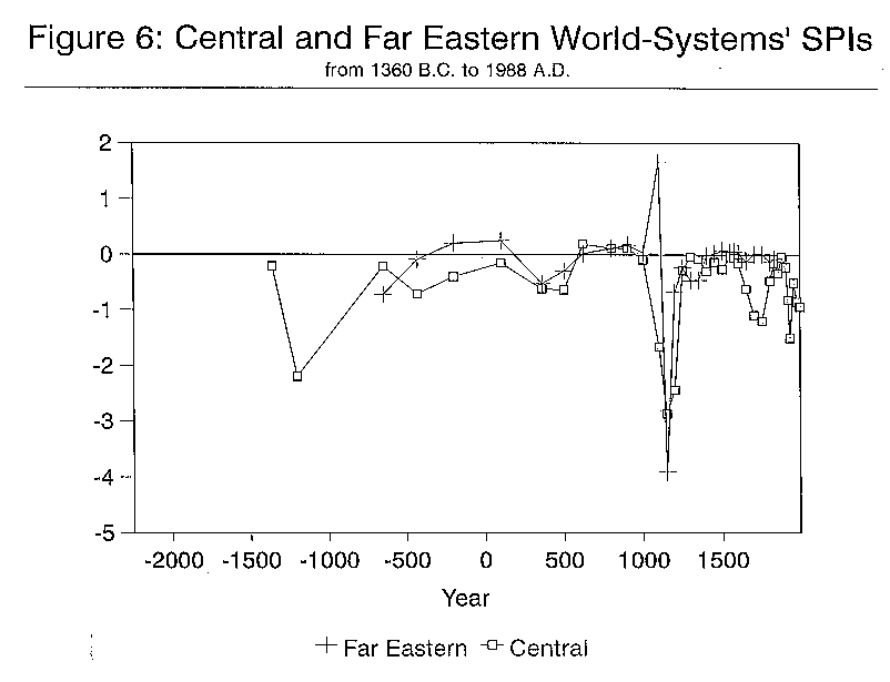
The correlations are not perfect. Looking at Figure 6 we see that the SPIs of the Far Eastern and Central systems were moving in opposite directions between 650 and 430 BC. But from 430 BC to 361 AD they moved up and down together like partners in a waltz. From 361 AD to 500 they again moved in different directions. But from 500 to 1000 AD they were very close (with one minor exception). From 1000 to 1100 they moved in radically opposite directions, but then they then moved together again until 1600 AD when Central began a descent to flatness which did not occur in Far Eastern. Now let us look at urban population changes in Figure 6A. Here the correspondence is even greater. From 650 BC to 500 AD they moved in tandem. Between 500 and 622 AD Central fell back a bit while Far Eastern rose steeply. Then they rose again together until 800, but then Far Eastern fell until 900 while Central kept rising. In what looks like a 100 year lag Central followed the fall of Far Eastern and they both continued to fall until 1150 when Far Eastern began to rise again. Central's rise did not begin until 1200. They both rose, wobbled a bit (but not simultaneously) and then rose again. Far Eastern experienced a big dip between 1600 and 1650 which did not occur in Central.
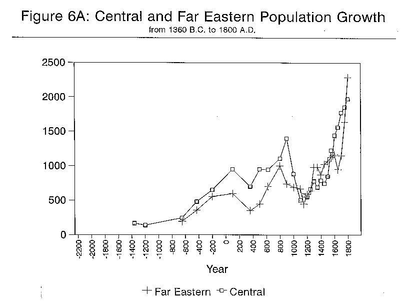
So what was going on here? Was this really one big system since the Bronze Age as Andre Gunder Frank (forthcoming) has claimed? David Wilkinson's criterion of political-military interconnectedness does not join Central and Far Eastern until 1825 AD. But his criterion of involvement in a single prestige goods trade network links China with West Asia, Europe and Africa in AD 622 (Wilkinson, 1992b:80). Talking of the growth of intermediate cities on the Silk Road, Wilkinson says, "Kashgar is the current indicator of the not-exclusively-Chinese character of Far Eastern civilization. Its presence, along with Samarkand, suggests that enough Eurasian trade exists to enroll the Far Eastern oikumene in the Old Oikumene."
Fine, but this does not account for simultaneous ups and downs in China and Western Asia since 430 BC. What does? Is it perhaps the case that, though the Gills/Frank periodizations of growth and decline are somewhat mis-specified, the general idea of a single Afro-eurasian world-system with nearly synchronous phases of growth and decline is correct? We hesitate to so conclude. But what are the alternatives?
First we should point out that the same comparisons with the Indic world-system, intermediate in space between Far Eastern and Central, bear much less fruit. Compare Figures 2 and 2a (and Tables 1 and 2) with Figures 6 and 6A. Neither the Indic SPIs nor the Indic urban populations rise and fall with either Central or Far Eastern. If there is a single Afro-eurasian world-system and if this is supported by Figures 6 and 6A, why doesn't the Indic region march to the same drummer?
It is, of course, possible that certain external influences have affected both Central and Far Eastern. Perhaps sun spots or climatic change. We are reminded of the sci fi novel (Vonnegut?) in which the Great Wall was built because an extra-terrestrial ship wrecked on a moon of Jupiter had written SOS in his home language by shining energy mirrors which affected the course of Far Eastern history.
A more likely candidate is epidemic diseases which spread across urban populations carried by long distance traders, as was the bubonic plague. William McNeill (1976) and Jane Abu-lughod (1989) have shown that epidemic diseases spread across the Eurasian continent at the end of the first millennium AD and continued to have large effects on urban populations for centuries. The theoretical question which this raises is the extent to which diseases might be understood as endogenous to a single system rather than an exogenous vector that impacts upon two separate systems. A much closer study than ours might be able to show the extent to which pandemics can account for the similtaneities revealed in Figures 6 and 6A. It is well-known to demographers that the effects of epidemics are temporary in most cases. Cities usually recover from even massive depopulations due to death from diseases. If this is the case diseases might account for temporary depopulations across Eurasia but not for the more long-lasting waves of growth and decline or changes in city size hierarchies.
Another possible candidate for exogenous factor is "barbarian" invasions. We have shown that these sometimes have large effects on city systems. The precipitous drop in the Far Eastern SPI between 1100 AD and 1150 was undoubtedly due to the invasion and conquest by the Ch'in Tarters. But the Mongol invasion and conquest in the following century had only a minor effect on the city system of China. One problem is to understand when invasions have massive effects versus the circumstances under which they have only moderate effects. Did more or less contemporaneous surges of peripheral populations out of Central Asia affect the Far Eastern and Central city systems in such similar ways as to produce some of the similarities observed in Figures 6 and 6a? And if this was the case, should this be understood as an exogenous factor impacting on two separate systems or as an endogenous feature of a single interacting system?
Yet another possibility is that urbanizing world-systems go through similar sequences of development, cycles of political centralization/decentralizing and trends of long-term city growth. If two such disconnected systems happened to start at the same time, parallel evolution would produce similar trajectories. This seems far-fetched but it is possible. India does not fit the pattern but perhaps its starting point was different. Comparison of the Indic system graphs with those of Far Eastern and Central shows a completely different sequence which does not correspond even if the time scale is shifted.
A Plausible Account
We will propose an explanation which combines a number of the above factors, a combination of parallel evolution and systemic interaction. Suppose that two separate world-systems, each at a different end of a long continent, begin to develop cities and states at about the same time. At first they go through similar expansion and contraction phases because they have similar internal logics. They grow, and their growth affects the possibilities of regions which are intermediate in space closer to the center of the large continental land mass. The center of the continent has two kinds of regions. In one of these ecological conditions are favorable for the development of a state-based urbanized world-system and one develops there. In the other region ecological conditions are unfavorable for the production of agricultural surplus but the people who live there can raise horses. They selectively borrow cultural, institutional and military features from the three core regions. Eventually growth leads to interaction among the three core regions, but the ones at the extremes of the continent are interacting indirectly, mediated by the two intermediate regions, one itself an emerging urbanized core and the other a specialized semiperipheral region of pastoralists.
The intermediate urbanized region (India) keeps having its trajectory of development interrupted by invasions, and so its pattern of development looks different. It has fewer and shorter periods of political integration and longer and deeper periods of stagnation. The intermediate peripheral regions (the steppes and oasis regions along the Silk Road) develop militarily specialized peoples who selectively borrow technology and culture from the cores at both ends of the continent. They also experience a cycle of state formation and the disintegration of states, but the states that they form are based on their ability to extract surplus from the urbanized core regions rather than on the accumulation of surplus from "their own" peasant farmers. Their sequences of political centralization/decentralization are generally in phase with the cycles of the urban cores and act upon these to produce the near simultaneities we see in Figures 6 and 6A.
This is a modification and specification of the argument presented in Andre Gunder Frank's essay, "The Centrality of Central Asia." It builds also on the findings of Thomas Barfield's (1989) study of the relationship between state formation among steppe nomads and Chinese urbanized empires. We see this as an instance of a general model of "semiperipheral development" in which formerly peripheral areas combine some of the features of peripherality with some features of coreness to produce new institutional and technological features which enable them to conquer and restructure core regions (Chase-Dunn,1988). This general model considers semiperipheral marcher states to be one of several types of semiperipheral development which have occurred in different kinds of world-systems.
In applying this model to the case of steppe nomads and Silk Road oasis cities several problems need to be addressed. The steppe nomads look more like peripheral than semiperipheral peoples, and in this they differ from other semiperipheral marcher states in world history. The more usual semiperipheral marcher states are recently urbanized polities on the edge of an old core area. Examples are Agade, Macedonia or Rome. The uniqueness of the steppe nomad empires is mostly due to the impossibility of intensive agriculture on their home terrain. Many other semiperipheral marcher states were populated by pastoralists who had only recently settled down, but the steppe nomad empires were formed in the steppes themselves. As Owen Lattimore (19 ) first pointed out, the pastoralists of central Asia developed their way of life in interaction with the farmers of the Yellow River valley. They were specialized producers of domesticated animals who traded with sedentary farmers for thousands of years before they began forming in to large military alliances. In this instance they were involved in an interregional division of labor in which they were specialized in a form of production which involved relatively less population density and which was less susceptible to the emergence of class hierarchy. This is an instance of what Chase-Dunn and Hall (1991) term "core/periphery differentiation." In many other cases the more hierarchical and population dense societies within such an intersocietal division of labor are able to exploit and dominate there less dense and hierarchical trade partners and a true "core/periphery hierarchy" emerges. But this does not always happen.
In the case of the steppe nomads of Central Asia the peripheral peoples themselves organized huge states and these states were specialized military mechanisms for extracting surplus from the agricultural core regions. Barfield's explication of the inner frontier and outer frontier strategies of these states explains this well. When these formerly peripheral peoples developed specialized states for extracting resources from cores we think it makes sense to call them semiperipheral. One meaning of semiperipherality is the combination of core with peripheral organizational features. The creation of a large scale military machine is most typically a feature of core regions. The military use of horses formed into swift cavalries of archers can be understood as the creative blending of core military organization and peripheral resources.
The cases of the Silk Road cities and their peoples needs also to be more closely examined from this perspective. The oasis cities that lived on the business of the caravans carrying prestige goods between the Far Eastern, Central and Indic systems were similar in some respects to another general class of semiperipheral cities -- the maritime capitalist city states such as Dilmun, the Phoenician cities, Malacca, Venice and etc. But most of these latter did not conquer urbanized core regions. They made a business of trading in the interstices between land-based states and empires and operated as agents of commodification within the commercializing, but still predominantly tributary systems (Chase-Dunn,1992). Occasionally a semiperipheral city of traders switched to the marcher state road. Examples are Assur and, unsuccessfully, Carthage. The Silk Road cities had fewer opportunities than the maritime city states because they were more completely dependent on a single trade route. This meant that they were even more likely to try the marcher state road and/or to insinuate themselves into the politics of empires. The Uighur started as soldiers for the Western empires and eventually became the Seljuk and Ottoman Turks with Western empires of their own.
So, to sum up, Central and Far Eastern started as separate systems but they both had effects on the peripheral peoples of Central Asia. Interaction with these peoples eventually acted back on both of them and this created a dynamic which affected both of their city systems nearly simultaneously. In addition to this the economic interactions between Far Eastern and Central also came to play some role in transmitting economic forces between them. This was the thesis of Frederick Teggart's Rome and China.
Whether or not the above is the best explanation needs to be subjected to further scrutiny. We need to look for ways in which the immediate political processes of rise and fall discussed in the examinations of the two systems separately (above) may have been linked by intermediate factors involving semperipheral Central Asian peoples, disease transmissions and long distance trade dynamics.
We know that the crash of the Northern Sung city size hierarchy between 1000 AD and 1150 AD was due primarily to the Chin Tartar conquest. Was this linked in some way to what was happening in the Central system? The fairly precipitous flattening of the Central SPI started steeply down in 1000 AD. This was partly due to the fall of the Umayyad caliphate and its consequent reduction in population of Cordova, which had been the largest city in 1000 AD. The Central system continued to fall to its most extreme flatness in 1150 and this lasted until 1200. This was also a period of radical urban population decline. We do not really know why this occurred, but the fall of Cordova did not have anything to do with invasions from Central Asia. A better handle on the causes of demographic and city hierarchy decline in the nine, tenth and eleventh centuries could help us evaluate the proposed explanation above for the correspondence we find between the city size distributions and urban growth patterns of Central and Far Eastern systems. We also need to further examine the trajectories of other world-systems to see whether or not the hypothesis of parallel evolution holds water. We have data on Japanese cities but have not had time to examine them in this paper. With more work on Mesoamerican cities we could see whether or not the Mesoamerican world-system shows sequences which are similar to those we have found for Far Eastern and Central.
References
Abu-Lughod, Janet Lippman 1989. Before European Hegemony The World System A.D. 1250-1350 New York: Oxford University Press.
Barfield, Thomas J. 1989 The Perilous Frontier: Nomadic Empires and China. Cambridge, MA.: Blackwell
Blanton, Richard L., Stephen Kowalewski and Gary Feinman 1992 "The Mesoamerican world-system." Review 15,3:419-26 (Summer) Special issue on comparing world-systems
Carneiro, Robert 1978 "Political expansion as an expression of the principle of competitive exclusion." Pp. 205-23 in R. Cohen and E.R. Service (eds.) Origins of the State: the Anthropology of Political Evolution. Philadeplphia: Institute for the Study of Human Issues
Chandler, Tertius 1987 Four Thousand Years of Urban Growth: An Historical Census. Lewiston,N.Y.: Edwin Mellon Press
Chase-Dunn, Christopher 1985a "The system of world cities: A.D. 800-1975." Pp. 269-292 in Michael Timberlake (ed.) Urbanization in the World-Economy, New York:Academic Press.
______ 1985b "The coming of urban primacy in Latin America." Comparative Urban Research 11,1-2:14-31.
______ 1992 "The changing role of cities in world-systems." Pp. 51-88 in Volker Bornschier and Peter Lengyel (eds.) Waves, Formations and Values in the World System World Society Studies, Volume 2, New Brunswick, N.J.: Transaction Publishers.
Chase-Dunn, Christopher and Thomas D. Hall 1991 Core/Periphery Relations in Precapitalist Worlds. Boulder, CO.: Westview.
_______1993 "Comparing world-systems: concepts and working hypotheses" Social Forces, June. ______ Forthcoming.
_________"Explaining the historical evolution of world-systems" Chapter 2 in Rise and Demise: The Transformation of World-Systems.Boulder,CO.: Westview. Chase-Dunn,
Christopher, Edward Clewett and Elaine Sundahl 1992 ""A very small world-system in northern California: The Wintu and their neighbors" A paper presented at the annual meeting of the Society for American Archaeology, Pittsburgh, April 8-12.
Chi, Ch'ao-ting 1963 [1935] Key Economic Areas In Chinese History: As Revealed in the Development of Public Works for Water-Control, New York: Paragon Books.
Elvin, Mark 1973 The Pattern of the Chinese Past, Stanford: Stanford University Press. Fitzpatrick, John 1992 "The Middle Kingdom, the Middle Sea and the geographical pivot of history." REVIEW 15,3:477-522 (Summer).
Frank, Andre Gunder 1992 "The Centrality of Central Asia" Comparative Asian Studies Number 8. ______ Forthcoming. "The world-system and its cycles in the bronze and iron ages." Current Anthropology
Friedman, Jonathan and Michael Rowlands 1977 "Notes toward and epigenetic model of the evolution of 'civilization'" Pp.201-78 in Friedman and Rowlands (ed.) The Evolution of Social Systems. London: Duckworth.
Gills, Barry K. and Andre Gunder Frank 1991 "World system cycles, crises and hegemonial transitions." A paper presented at the annual meetings of the International Studies Association, Vancouver, March 19-23
Gungwu, Wang 1963 The Structure of Power in North China During the Five Dynasties. Stanford: Stanford University Press.. Hsu, Cho-yun 1965 Ancient China in Transition: An Analysis of Social Mobility, 722-222 B.C. Stanford: Stanford University Press.
Johnson Allen W. and Timothy Earle 1987 The Evolution of Human Societies. Stanford: Stanford University Press.
Kowalewski, Stephen A. 1982 "The evolution of primate regional systems" Comparative Urban Research 9,1:60-78.
Lattimore, Owen 1940 Inner Asian Frontiers of China. New York: American Geographical Society.
Lightfoot, Kent G. and Gary M. Feinman 1982 "Social differentiation and leadership development in early pithouse villages in the Mogollon region of the American Southwest" American Antiquity 47,1:64-86.
Ma, Lawrence J.C. 1971 Commercial Development and Urban Change in Sung China, 960-1279. Ann Arbor: Michigan Geographical Publication #6, Department of Geography, University of Michigan.
Mann, Michael 1986 The Sources of Social Power: A History of Power from the Beginning to A.D. 1760. Cambridge: Cambridge University Press.
McNeill, William H. 1976 Plagues and People Garden City, NJ: Anchor Books. Nissen, Hans J. 1988 The Early History of the Ancient newar East, 9000-2000 BC Chicago: University of Chicago Press.
Renfrew, Colin 1986 "Introduction: peer polity interaction and socio-political change," Pp. 1-18 in C. Renfrew and John F. Cherry (eds.) Peer Polity Interaction and Socio-political Change Cambridge: Cambridge University Press.
Sahlins, Marshall 1972 Stone Age Economics. Chicago: Aldine
Schneider, Jane 1991 "Was there a pre-capitalist world-system?" Pp. 45-66 in C. Chase-Dunn and T.D. Hall (eds.) Core/Periphery Relations in Precapitalist Worlds. Boulder, CO.: Westview.
Taagepera, Rein 1978a "Size and duration of empires: systematics of size" Social Science Research 7:108-27.
______ 1978b "Size and duration of empires: growth-decline curves, 3000 to 600 B.C." Social Science Research, 7 :180-96.
______1979 "Size and duration of empires: growth-decline curves, 600 B.C. to 600 A.D." Social Science History 3,3-4:115-38.
Teggart, Frederick J. 1939 Rome and China: A Study of Correlations in Historical Events Berkeley: University of California Press.
Walters, Pamela Barnhouse 1985 "Systems of cities and urban primacy: problems of definition and measurement." Pp.63-86 in Michael Timberlake (ed.) Urbanization in the World-Economy, New York: Academic Press.
Wilkinson, David 1987 "Central Civilization." Comparative Civilizations Review 17:31-59. ______1991 "Core, peripheries and civilizations." Pp. 113-166 in Christopher Chase-Dunn and Thomas D. Hall (eds.) Core/Periphery Relations in Precapitalist Worlds, Boulder, CO.: Westview.
______1992a "Decline phases in civilizations, regions and oikumenes." A paper presented at the annual meetings of the International Studies Association, Atlanta, GA. April 1-4.
______ 1992b "Cities, civilizations and oikumenes:I." Comparative Civilizations Review 27:51-87 (Fall).
Notes
1. We acknowledge Wilkinson's magnificent contribution to the comparative study of intersocietal systems and civilizations. His careful classificatory work has shown how many separate networks of interaction became the single global network in which we live today. His work on mapping political-military interaction networks and trade networks immensely clarifies the issues surrounding the debate about spatially bounding world-systems in the past. It should be pointed out that the kind of trade which Wilkinson has considered in specifying the boundaries of his trade "oikumenes" was trade in prestige goods. These trade "oikumenes" joined the smaller and still separate political/military interaction networks earlier than the dates of military/political incorporation. Thus, for example, Wilkinson's "Old Oikumene" contains both Egyptian and Mesopotamian political/military networks well before these became united as the single political/military interaction network which Wilkinson calls Central Civilization. We have taken the liberty of using a similar term, Central World-System, because we want to remind readers, as does Wilkinson's term, of the hybrid and engulfing character of this expanding systemic interaction network and because the term "civilization" is somewhat misleading for many readers because it has been so frequently used to mean a cultural entity based on central values. The systems that we are studying are frequently politically multicentric and they always contain several different and competing cultures, especially if we consider the broad semiperipheral and peripheral hinterlands that surrounded the core regions of these regional state-based world-systems.
2. We follow Johnson and Earle (1987 in defining true states as polities that are larger than chiefdoms and that have specialized institutions of regional administration and control.
3. See Wilkinson (1992b) for a comparison between Chandler's city lists and those derived from other sources. The business of estimating the population sizes of cities is fraught with error, especially when we are limited to archaeological evidence. The estimates get more accurate as we approach the present.
4. The largest city in 500 A.D. is Sialkot. We have estimated its population by interpolation from Chandler's (1987:465) list, which includes other cities outside of the Indic world-system. Normally we do not calculate an SPI if we do not have a firm estimate of the population the largest city in a system but in this case the interpolation from Chandler's list is a pretty good guess.
5. We follow Wilkinson's (1992b:68) preference in terminology. He says, "I have preferred the term 'Far Eastern civilization' to the more prevalent 'Chinese civilization' because of my conviction that the latter disguises unduly the ethnic mosaic of urban continental East Asia."
6. The cities which appear in Chandler's lists for the warring states period are all the capital cities of separate states. Within each state were smaller intercity networks which were themselves hierarchical. Hsu (1965:134) discusses a document which specifies the desirable shape of the intrastate city hierarchies:
8. Wilkinson (1993b:63) says, "To treat this "Central civilization," as a new entity (rather than a continuation of one of its component predecessors) is to imply that the merger of Egyptian with Mesopotamian civilizations took place on not too unequal terms."
9. Though Chandler provides a city list for 800 BC there is no estimate for the population of the largest city, Thebes, so we cannot calculate an SPI and neither can we determine the total urban population of the largest cities for a comparison with 650 BC. Thus we cannot, with our methods, evaluate Gills and Frank's (1991) hypothesis of a stagnation phase between 800 and 550 BC. Frank (forthcoming) is skeptical about this phase.