Uneven Political
Development:
Largest
Empires in Ten
world Regions and the Central International System since the Late Bronze Age*
Christopher
Chase-Dunn, Hiroko Inoue, Alexis Alvarez,
Rebecca
Alvarez, E. N. Anderson and Teresa Neal
Institute
for Research on World-Systems
University
of California, Riverside
Galactic or mandala polities
in Southeast Asia
To be presented at
the annual conference of the California
Sociological Association,
Holiday Inn -- Capitol Plaza (near
Old Town) Sacramento, November 13 and
14, 2015
An
earlier version was presented at the Fourth European Congress on World and
Global History, September 6, 2014, École Normale Supérieure, Paris
Draft
v. 11-16-15, 11102 words
*We are indebted to those prodigious coders who made quantitative
comparative studies of settlements and polities possible: Tertius Chandler, Rein Taagepera and George Modelski.
![]()
This is IROWS Working Paper #85
available at https://irows.ucr.edu/papers/irows85/irows85.htm
Data
appendix for this paper is at https://irows.ucr.edu/cd/appendices/worregs/worregsapp.htm
Abstract:
This is a part of a study of the growth of settlements and polities in ten world regions over the past 3500 years. We discuss changes in the relationships linking political/military power, economic power and settlement systems. And we compare East Asian urban and empire growth with the original heartland of cities and states in Southwest Asia and Africa, as well as with Europe, the subcontinent of South Asia, Central Asia, Southeast Asia, Oceania and the Americas. This quantitative measurement of the trajectories of largest city and empire growth and the changing relative scale of social organization in the different world regions provides an overall picture of the long-term patterns of uneven development in human sociocultural evolution and has important implications for analyses of the similarities and differences between the developmental trajectories of the world regions studied. We also investigate the extent to which the growth/decline phases of cities and empires in different world regions display synchrony or a see-saw (alternating) pattern across the centuries.
The
study of the long-run growth of settlements and polities is an important basis
of our understanding of comparative sociology and human sociocultural
evolution.[1] The processes by which a world inhabited by
small nomadic hunter-gatherer bands of humans became the single global
political economy of today involved the establishment and growth of
settlements, the expansion of interaction networks and the growing size of
polities. These processes of long-term growth and expansion were uneven in time
and space. There were cycles of growth
and decline. And some of those regions that originally developed larger cities
and polities were, in later epochs, no longer the leading regions.
Our
theoretical approach is the institutional
materialist comparative evolutionary world-systems perspective. World-systems are defined as being composed of those human
settlements[2]
and polities [3]
within a region that are importantly interacting with one
another. This
approach focuses on the ways that humans have organized social production and
distribution, and how economic, political, and religious institutions have
evolved in systems of interacting polities (world-systems) since the
Paleolithic Age. We employ an underlying model in which population pressures
and interpolity competition and conflict have always
been, and still remain, important causes of social change, while the systemic
logics of social reproduction and growth have gone through qualitative
transformations[4]
(Chase-Dunn and Lerro 2014: Chapter 2). Our larger
research project studies the development of settlements and polities by
comparing regional world-systems and studying them over long periods of time.[5]
Our approach to the spatial bounding of the
unit of analysis is very different from those who try to comprehend a single
global system that has existed for thousands of years. Gerhard Lenski (2005); Andre Gunder Frank
and Barry Gills (1994) and George Modelski (2002; and
Modelski, Devezas and
Thompson 2008) and Sing Chew (2001; 2007) all analyze the entire globe as a
single system over the past several thousand years. We contend that this
approach misses very important differences in the nature and timing of the
development of complexity and hierarchy in different world regions. Combining
apples and oranges into a single global bowl of fruit is a major mistake that
makes it more difficult to both describe and explain social change. Our
comparison of different world regions and interaction networks of polities
makes it possible to discover both the similarities and the differences. Global
comparisons among these regional systems are certainly appropriate, but the
claim that there has always been a single global world-system is profoundly
misleading. [6]
Our earlier studies have used data on city sizes and the territorial sizes of empires to examine and compare different regional interaction systems (e.g. Chase-Dunn, Manning and Hall 2000; Chase-Dunn and Manning 2002; Inoue et al 2012; Inoue et al 2015). This article is a re-examination of the empire size data that uses better estimates and that will enable us to address claims about the relative importance of China and Europe that have been advanced by Andre Gunder Frank (1998) and more recently by Ian Morris (2010; 2012) and to reflect on the similarities and differences of the trajectories of development in the ten world regions we are studying.
The question we will try to answer in this article is: what
can patterns of polity growth tell us about the trajectories of development of
the different world regions and the expanding Central System? This paper is the
second part of a study that also uses the sizes of largest cities in world
regions to examine the nature of uneven development (Chase-Dunn, Inoue, A.
Alvarez, R. Alvarez, Anderson and Neal 2015).[7] But this paper looks only
at the sizes of the largest polities in each world region.
The issue of systemness and the spatial boundaries of whole
human systems remains contentious in social science. The description of
Earth-wide “global” history and processes is certainly a valid exercise, but
the question of bounding whole systems is more complicated. It depends on what
is meant by systemness. The idea of a whole system requires
being explicit about what is within the system and what is designated as
exogenous. Some explicit world-systems theoretical approaches claim that the
whole of humanity has constituted a single world-system since the emergence of
modern humans. This position has been explicitly taken by Gerhard Lenski (2005). Andre Gunder Frank and Barry Gills (1994) contended
that what they call “the world
system” emerged when states and cities arose in
Mesopotamia 5000 years ago. Frank
and Gills (1993:16, 84-85) designated a number of turning points of gradual
inclusion of world regions into the world system. Five thousand years ago
it was constituted only as Egypt and Mesopotamia, but China and the rest of
Eurasia became part of the system around 500 BC, and the incorporation of
Americas occurred after 1492. Their position was adopted by Sing
Chew 2001; 2007, but see 2014).
Immanuel Wallerstein
(2011[1974]) contended that the modern world-system was not yet global when it
emerged in Europe and the Americas in the long 16th century CE.
Chase-Dunn and Hall (1993; 1997) defined world-systems as human interaction
networks in which the interactions were two-way and regular. They adopted a
place-centric approach to spatially bounding world-systems because of the
observation that all human groups interact with their neighbors and so if you
count all indirect connections there has been a single linked network since the
humans populated the continents. The ideas of “fall-off” of effects of
interaction and place-centricity were adopted from archaeology.
The study of world
regions that we have undertaken here is not meant to confound the spatial
bounding of whole human interaction systems by means of interaction networks.
Rather it is intended to shed light on the literature that has emerged from the
critique of Eurocentrism and the rise of other centrisms.
We acknowledge that Eurocentrism has had huge detrimental effects on the
efforts of social scientists to describe and explain human sociocultural
evolution. And we agree that looking at reality from different perspectives is
a valuable exercise that can be enlightening and make big contributions to the
effort to explain the human past and present. We contend that the methodological
approach developed by Chase-Dunn and Hall for spatially bounding world-systems
is capable of providing a non-centric (or cosmocentric)
method for comparing small, medium-sized and large whole human systems. This
said, we admit that important work still needs to be done to accurately specify
the timing and location of changes in the spatial boundaries of world-systems (see
Chase-Dunn, Wilkinson, Anderson, Inoue and Denemark
2015).
Results of Our Earlier Studies of
Scale Changes of Polities and Settlements
Our studies have used data on city sizes and
the territorial sizes of empires to examine and compare different regional
interaction systems (e.g. Chase-Dunn, Manning and Hall 2000; Chase-Dunn and
Manning 2002; Inoue et al 2012; Inoue
et al 2015). We have identified those instances in world
history for which quantitative indicators are available in which the scale of
polities and settlements have greatly increased. These are termed upsweeps
(Inoue et al 2012; Inoue et al 2015). We also identify downsweeps
and system-wide collapses in which the largest polities or settlements declined
below the level of the previous low point and stayed down for more than one
typical cycle. Using this method we found that, while the decline of individual
cities and empires was part of the normal cycle of rise and fall, there were
very few system-wide collapses in which a downsweep
was not followed very soon by another rise.
We also found a greater
rate of urban cycles in the Western (Central) system than in the East Asian
system, which supports the usual notion that the Western city system was less
stable than the Eastern city system. And our finding that the Central system
experienced two urban collapses, while the Eastern system experienced downsweeps but not collapses, supports the idea of greater
stability in the East. We found that nine of the eighteen urban upsweeps we
identified were produced by semiperipheral
development and eight directly followed, and were caused by, upsweeps in the
territorial sizes of polities.
We also
examined twenty-four upward sweeps of the largest polities in four world
regions and in the expanding Central interpolity
system since the Bronze Age to determine whether or not the upsweeps were (or
were not) semiperipheral marcher states. (Inoue, Álvarez,
Anderson, Lawrence, Neal, Khutkyy, Nagy and
Chase-Dunn 2013). We found that over half of the twenty-two
identified empire upsweeps were likely to have been produced by marcher states
from the semiperiphery (10) or from the periphery
(3). This means that the hypothesis of semiperipheral
development does not explain everything about the events in which polity sizes
significantly increased in geographical scale, but also that semiperipheral development must not be ignored in any
explanation of the long-term trend in the rise of polity sizes.
Relative Regional Complexity
Andre
Gunder Frank’s (1998) provocative study of the global
economy from 1400 to 1800 CE contended
that China had long been the center of an already global system. Frank also
argued that the rise of European power was a sudden and conjunctural development
caused by the emergence in 18th century China of a “high level
equilibrium trap” and the success of Europeans in using bullion extracted from
the Americas to buy their way into Chinese technological, financial and
productive success. Frank contended that
European hegemony was fragile from the start and will be short-lived with a
predicted new rise of Chinese global predominance in the near future. He also
argued that scholarly ignorance of the importance of China invalidates all the
social science theories that have mistakenly characterized the rise of the West
and the differences between the East and the West. In Frank’s view there never
was a transition from feudalism to capitalism that distinguished Europe from
other regions of the world. He argued that the basic dynamics of development
have been similar in the single global system for 5000 years (Frank and Gills
1994).
A
related effort to compare world regions as a window on relative sociocultural
evolution is contained in two recent books by Ian Morris (2010; 2012). Morris’s big idea is
that complex human systems, like other complex systems, need to capture free
energy in order to support greater scale and complexity, and that the ability
to capture free energy is the main variable that accounts for the growth of
cities and empires in human history. Morris traces the increasing size of human
settlements since the origins of sedentism in the Levant
about 12,000 years ago. And he uses estimates of the sizes of the largest
settlements in world regions as a main indicator of system complexity. Using
this method he notes that there was parallel evolution of sociocultural
complexity in Western Asia and Northern Africa, South Asia, East Asia, the
Andes and Mesoamerica, and that the leading edge of the development of
complexity diffused also from its points of origin. And sometimes the original
centers of complexity lost pride of place because new centers emerged out on
the edge. The Bronze Age Mesopotamian heartland of cities now has none of the
world’s largest cities. Development was spatially uneven in some regions, with
the center moving to new areas.
In the introductory chapter of The Measure of Civilization Morris
provides a useful overview of earlier efforts to measure social development,
and he also provides a helpful and insightful discussion of the social science
literature on sociocultural evolution since Herbert Spencer. Morris’s research is
unusual for an historian because he carefully defines his concepts, specifies
his assumptions and operationalizes his measures, and then uses the best
quantitative estimates of settlement sizes as the main basis of the story he is
telling. His estimates of the sizes of the largest cities utilize, and improve
upon, earlier compendia of city sizes.
The main focus of Morris’s Why the West Rules is the comparison of
what happened in Western Asia, the Mediterranean and Europe with what happened
in East Asia. Morris is careful to trace the histories of the diffusion of
complexity in these areas. Morris makes contemporaneous comparisons between the
East Asian and Western regions in which he notes the existence of a see-saw
pattern back and forth regarding which region was ahead or behind in the
development of sociocultural complexity.
The West (Western Asia) had an original head-start, but the East caught
up and passed, and then the West (Europe and North America) passed the East
again.
While The Measure of Civilization is about the quantitative basis of
Morris’s analysis, Why the West Rules
adds a lot of detail beyond the basic focus on energy capture. But the energy capture idea misses some of
the patterns that are of interest to those who want to study whole
world-systems over long historical time. The story tends to be rather
core-centric with little attention paid to the transformative roles played by
peripheral and semiperipheral marcher states and
city-states in the construction of large empires and the expansion of trade
networks. Morris does not discuss the
transformation of systemic logics of development over the long period he
studied, or how differences in the development of capitalism may have been an
important contributor to the rise of Europe.
But the foregrounding of energy and cities is a valuable strategy for
comprehending both the patterns of history and for considering the present and
the future of human sociocultural development.
Immanuel Wallerstein’s (2011 [1974]) analysis
of East-West similarities and differences that account for the rise of
predominant capitalism in Europe and the continued predominance of the
tributary logic in East Asia is presented in Chapter One of Volume 1 of The Modern World-System. Summing up his
detailed discussion of the main factors that account for the East/West
divergence, Wallerstein says:
The essential difference between China and
Europe reflects once again the conjuncture of a secular trend with a more
immediate economic cycle. The long-term secular trend goes back to the ancient
empires of Rome and China, the ways in which and the degree to which they
disintegrated. While the Roman framework remained a thin memory whose medieval
reality was mediated largely by a common church, the Chinese managed to retain
an imperial political structure, albeit a weakened one. This was the difference
between a feudal system and a world-empire based on a prebendal
bureaucracy. China could maintain a more advanced economy in many ways than
Europe as a result of this. And quite possibly the degree of exploitation of
the peasantry over a thousand years was less. To this given, we must add the
more recent agronomic thrusts of each, of Europe toward cattle and wheat, and
of China toward rice. The latter requiring less space but more men, the secular
pinch hit the two systems in different ways. Europe needed to expand
geographically more than China did. And to the extent that some groups in China
might have found expansion rewarding, they were restrained by the fact that
crucial decisions were centralized in an imperial framework that had to concern
itself first and foremost with short-run maintenance of the political
equilibrium of its world-system. So China, if anything seemingly better placed prima
facie to move forward to capitalism in terms of already having an extensive
state bureaucracy, being further advanced in terms of the monetization of the
economy and possibly of technology as well, was nonetheless less well placed
after all. It was burdened by an imperial political structure (p. 63).
We now know much more about China because of
the careful comparative work of the “California School” of world historians
(e.g., Bin Wong 1997; Kenneth Pomeranz 2001) and
Giovanni Arrighi’s Adam Smith in Beijing (2007) as well as the important collection of essays in Arrighi, Hamashita,
and Selden (2003).
But Wallerstein’s analysis of the main elements explaining the East/West
divergence since the sixteenth century is still the best because of its
fruitful combination of millennial and conjunctural
time scales.
Frank’s
model of development in Reorient focuses mainly on state expansion and
financial accumulation. His study of global flows of specie, especially silver,
was an important contribution to our understanding of what happened between
1400 and 1800 CE (see also Flynn 1996).
Frank also uses demographic weight, and especially population growth and
growth of the size of cities, as an indicator of relative developmental
success.
It
is our intention to systematically examine the growth of the largest
settlements and polities in order to shed more light on Frank’s and Morris’s
claims about the relative development of East and West. Our study will begin in
1500 BCE when we first have reliable absolute years for the population sizes of
cities and the territorial sizes of states and empires in different world
regions.
Chronologies for Comparative Analysis
For purposes of comparing the timing of changes
in city and polity sizes across different world regions it is important to have
accurate absolute chronologies for the regions being compared. Unfortunately
there is still considerable disagreement about the absolute dating for
Mesopotamia before 1500 BCE. Mario Liverani (2014:
9-16) explains why estimates of absolute dates are so uncertain. Relative dates
of events needed for estimating polity sizes are based on “king lists.” Thus an
event, such as a conquest, is said to have occurred in the third year of the
reign of King X. Considerable effort has been made to figure out the
correspondences between different king lists in Mesopotamia and their
correspondence with Egyptian king lists. These are then converted in to
calendar years by ascertaining their relationships with astronomical events
such as eclipses. Unfortunately there is a period after the fall of the
Babylonian empire in which king lists are missing for Mesopotamia, and there is
disagreement about the timing of astronomical events. Thus the length in years
of the occluded period is in dispute, and this results in so-called, short,
medium and long chronologies for the period before the Late Bronze Age, with an
error of as much as 100 years.[8]
Our efforts to estimate the sizes of polities are dependent on absolute dating
because we want to compare across world regions. So it matters to us
whether Ur was sacked in 2004 BCE, and thus is eliminated from the list of
large cities and large polities in 2000 BCE, or in some other year 50 years
earlier or later. Liverani (2014: 15) is satisfied to
use the middle chronology for Mesopotamia and the surrounding regions, but he
is not trying to compare the timing of changes in the Ancient Southwest Asia
with other world regions. So we begin in 1500 BCE.
Another temporal issue that we
should mention is the effort we have made to code the sizes of polities as
snap-shots taken every 100 years.
George Modelski (2003) had already organized
the city population estimates into 100 year intervals, but Rein Taagepera’s (1978a;1978b; 1979; 1997) estimates of polity
sizes were organized according to the year of the events that caused changes in
the sizes of polities, mainly conquests and rebellions. In order to be able to
compare city and polity sizes we converted Taagepera’s
estimates to the same time points as we are using for cities by means of
interpolation. We also improved upon Taagepera’s estimates by using more recent Atlases and web
sources such as Geacron and Wikipedia that have
information about the history of polities. But using 100-year snap-shots could
miss some important developments that are relevant to the study of scale
changes in polity and city sizes. So, for example, in
order not to miss the huge but short-lived Mongol Empire we have added 1250 CE
as a time point.
Units of analysis: world regions and interaction
networks
The comparative evolutionary world-systems perspective spatially bounds world-systems as networks of interacting polities (Chase-Dunn and Hall 1997: Chapter 3; Chase-Dunn and Jorgenson 2003). In most of our studies we use political/military interaction networks (PMNs) composed of fighting and allying polities as the unit of analysis. But in this paper we want to examine the different trajectories of world regions. PMNs have the disadvantage that they expanded and contracted over time as smaller regional networks merged or were engulfed by larger systems, eventuating in the single global system of today. Thus all the world regions eventually became incorporated into a single global network that we call the Central International System, following Wilkinson (1987).[9] In order to compare the trajectories of different world regions, which is the main purpose of this article, we will hold the spatial boundaries of the ten specified different regions constant over time. This allows us to trace the timing and trajectories of changes in the spatial scale of settlements and polities without worry that the changes we find are due to alterations in the spatial boundaries of the regions we are studying. We will also want to compare our constant region findings with studies of expanding political-military networks, especially the Central PMN.
Thus the main unit of
analysis in this study is the world region, and regions are held
constant over the whole period. The ten
regions we will study are:
1.
Europe, including the Mediterranean and
Aegean islands, that part of the Eurasian continent to the west of the Caucasus
Mountains, but not Asia Minor (now most of Turkey).
2. Southwest Asia- Asia Minor (now Turkey), the Arabian Peninsula, Mesopotamia, Syria, Persia, the Levant, and Bactria (Afghanistan), but not north of Afghanistan.
3. Africa, including
Madagascar.
4. The South Asian
subcontinent, including the Indus river valley and Sri Lanka.
5. East Asia,
including China, Korea, Japan and Manchuria.
6. Central Asia and
Siberia: We define Central Asia broadly as:
the territory that lies between the eastern edge of the Caspian Sea
(longitude E53) and the old Jade Gate near the city of Dun Huang near longitude
E95, and that is north of latitude N37, (which is the northern edge of the
Iranian Plateau, the northern part of Afghanistan and the mountains along the
southern edge of the Tarim Basin). The northern
boundary is the northern edge of the steppes as they transition into forest and
tundra. So the Central Asia region we are studying includes deserts, mountains
and grasslands (steppes) (Hall et al
2009).
7. Southeast Asia,
including Indonesia, Malaysia, the Philippines, Cambodia, Burma, Vietnam and
Thailand.[10]
8. Oceania, the islands of
the Pacific including Australia, New Zealand and Borneo (Papua and Papua New
Guinea).
9. North and Central
America
10. South America,
including Panama and the Caribbean Islands
For some purposes we will also use the expanding Central PMN as a unit of comparison.
The ten specified world regions are defined for
purposes of examining the claims made by Frank and Morris about relative
development of cities and empires (see Figure 1). [11]
These specified world regions are somewhat arbitrarily bounded but we have
developed this spatial set of categories based on our knowledge of where large
cities first emerged, and with attention to the issue of large empires.[12]
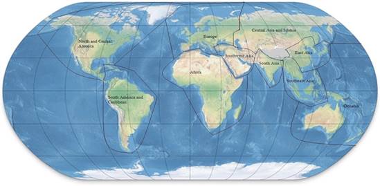
Figure 1: The ten world regions we are using for comparisons
Measures of relative complexity based
on the territorial sizes of empires
Determining relative
sizes requires real metric (interval-level) estimates, not just periodizations of growth and decline. What we want to know
is the size of the area over which a
central power exercises a degree of control that allows for the appropriation
of important resources (taxes and tribute). The ability to extract
resources falls off with distance from the center in all polities, and
controlling larger and larger territories requires the invention of new
transportation, communications and organizational technologies [what Michael
Mann (1986) has called “techniques of power”]. Military technologies and
bureaucracies are important institutional inventions that make possible the
extraction of resources over great distances, but so are new ideologies and new
technologies of communication (Innis 1950).
Political boundaries between states were not usually as formalized
before the modern era, and so these boundaries were often fuzzy regions of
declining ability to extract resources.
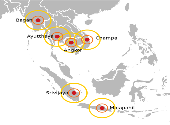
The galactic or mandala model of state structure developed by Stanley Tambiah (1977) to understand political structures in
Southeast Asia is broadly applicable. Thus the territorial size estimates that
have been compiled for Bronze and Iron Age polities contain a rather large
error component and these estimates, like the estimates of the population sizes
of cities, need to be continuously evaluated with consideration to recently
developed historical knowledge about the polities and regions.
Not all maps in political atlases
show the boundaries of territorial control. They may represent linguistic or
religious groups or other distinctions that have little or nothing to do with
state power. And maps may not have good time resolution. Our estimates of the
territorial sizes of polities are mainly derived from the published articles of
Rein Taagepera (1978a, 1978b, 1979, 1997).[13]
Following Taagepera, we use square megameters to indicate the territorial sizes of polities. A
square megameter is a territory that is 1000 by 1000
kilometers in size.
Of
course territorial size is only a rough indicator of the power of a polity
because areas are not equally significant with regard to their ability to
supply resources. A desert empire may be large but weak. But this rough
indicator is quantitatively measureable in different world regions over long
periods of time, so it is valuable for comparative historical research.
Estimating
the territorial sizes of states and empires is based on the use of published
historical atlases and histories. It is very difficult to estimate the sizes
and political boundaries of polities with archaeological evidence alone. So
documentary evidence is the basis of these estimates. For the ancient and
classical worlds these are based primarily on knowledge about who conquered which
city, and whether or not and for how long tribute was paid to the conquering
polity. Knowledge of rebellions is also used to gage instances in which states
get smaller. Only asymmetrical (unequal) exchange signifies a tributary
imperial relationship. Otherwise it is just trade and does not signify an
extractive relationship and a boundary of political control. Sometimes it is
difficult to tell whether or not tribute is asymmetrical or symmetrical
exchange. Chinese dynasties often required formal suzerainty and tribute from
other states but also sent elaborate gifts to their alleged vassals. In some
cases (as with Central Asian steppe confederacies) the balance seemed to have
gone away from China rather than toward it.
Polities not only get larger, but their structures evolve over the
period of our study. Early states expanded into territorial empires, and then
large non-contiguous colonial empires emerged, and then these were replaced by
contiguous modern nation-states. Most of the large ancient and classical
empires involved the conquest of territory that that was contiguous with the
home territory. But once naval power was taken up by tributary states an empire
could conquer and dominate a client state that was far from its home territory,
such as Rome’s control of areas on the south shore of the Mediterranean Sea. If
these distant non-contiguous tribute-payers were small in number and/or size,
not including them in the estimates of the territorial sizes of empires would
not constitute a large error. But, as capitalism moved from the semiperiphery to the core, capitalist nation-states
increasingly adopted the thallassocratic form of
empire that had been pioneered by semiperipheral
capitalist city-states[14]—control
over distant overseas colonies. The modern colonial empires (British, French,
etc.) require estimating the territorial sizes of colonies that are spread
across the seas. Waves of decolonization have eventuated in the contemporary
international system of polities in which the largest are contiguous modern
nation-states such as Russia, the United States, Brazil, etc.. The increasing
institutionalization of the territorial boundaries of states makes it much
easier to determine the territorial sizes of polities than it was in the
ancient and classical worlds in which polity boundaries were often very fuzzy.
Comparing polity sizes across world
regions and PMNs
The
results of our comparisons of relative sizes of polities have important
implications for the huge literature that compares the trajectories of state
formation and economic development in East Asia with that of the West. Most of
the earlier literature compares China with Europe. Our use of world regions
allows us to compare East Asia with Europe, but also to track the political
military network (PMN) that came out of Mesopotamia and Egypt and expanded west
to include the Mediterranean, and eventually the Americas and east to include
South Asia. This is a comparison of the East Asian PMN with the Central PMN.
States and empires sometimes cross the boundaries between our designated world
regions. When this happens we assign the territorial size of the polity to the
region that contains its capitol.
Walter Scheidel’s
(2009) insightful consideration of the similar and different trajectories of
China and the Mediterranean contends that there were two great divergences. The
one that occurred in the 18th and 19th centuries has
received a lot of attention from Ken Pomeranz (2000),
who named it “the great divergence”, but also from Bin Wong (1997) and Andre Gunder Frank (1998).
Scheidel (2009) notes that there was an
earlier great divergence between China and the West. Both the Roman and the Han empires managed to
bring huge territories under a single authority, but after they declined
different things happened in the West and the East. In the East the decline of the Han was
followed, after an interval, by the rise of the Tang empire, which was nearly
as large as the Han had been. In the West, after the fall of Rome another
empire of a similar huge size, uniting the entire Mediterranean littoral, never
rose again. This was the first great
divergence. Scheidel
(2009: 12-13) also compares the percentage of time that the core of each region
has been politically united. He cites Victoria Hui (2008:59) regarding the
percentage of time between 214 BCE and 2000BCE that the Chinese core, defined
as the region controlled by the Qin dynasty at its height in 214 BCE, has been
united (42%). Hui is making the point that China has been less united than most
observers believe, but Scheidel (2008:13) reports
that “the western ecumene that was under Roman rule
at the death of Augustus in 14 CE” has been united for only 18% of the time,
and not at all for the past 16 centuries. Empires did emerge in the West after
the fall of Western Rome, but none of them were able to take over the entire
core region that had been held by Rome. [15]
The first great divergence can be
seen in Figure 5 below. Scheidel contends that
geographical and climate differences do not explain the first divergence. He assumes that empires are easier to erect
when there are fewer barriers to transportation and communication. He asserts
that the core region of China in two river valleys is a more difficult region
to integrate relative to the Mediterranean littoral because mountain ranges
separate the valleys. Indeed central regulation and control may be less needed
in a system in which the network structure was itself less centralized or
linear.[16]
Greater transportation and
communications costs (up to a point) give greater incentives for the non-center
to go along with the center because the center provides access to many
different locales.
The Mediterranean “Middle Sea” allowed many
network nodes to connect directly with many other nodes. Centralized control was
not needed in order to facilitate interaction. In China the Grand Canal project
that linked the valley of the Huang He River with the river valleys of
the south
by water required a centralized authority to build and maintain it while the
Middle Sea did not. Of course there were several other differences that may
have contributed to the first great divergence. Phonetic alphabets had been
adopted in the West, allowing local languages to each be written in their own
way, but making cross-language communication more difficult. The ideographic
characters used in China allowed different languages to use the same symbols,
making it possible for speakers of very different languages to read the same
documents. Scheidel
also mentions the possibility that differences in the nature of the
legitimation of authority may have facilitated centralization in China, but not
the West. The Chinese state used legalism and Confucianism, while the West
experienced competing (and conflicting) transcendent otherworldly religions.
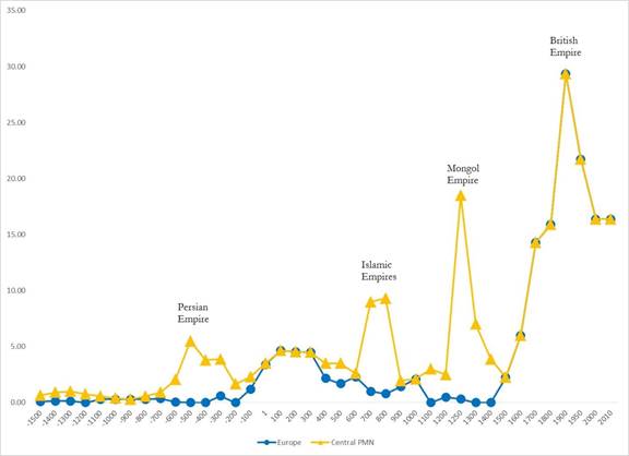
Figure 2: Sizes of largest polities in Europe and in the Central PMN
We will
be comparing East Asia with both Europe and the Central PMN below but the first
question is to compare Europe and the Central PMN to one another. So Europe and
the Central PMN overlap over most of the period we are studying, but the
Central PMN is larger. When Morris and Scheidel
compared East Asia (mainly China) with “the West” they were usually thinking
about what we here call the Central PMN. But much of the literature on
East/West comparisons is about Europe (the “little West”) and China. So here we
do both. Figure 2 shows the differences that it makes when we look at the
largest polities in the expanding Central PMN vs. in Europe as a constant world
region. These two series are rather highly correlated (partial Pearson’s r =
.78, see Table 2 below) but they diverge during certain periods. The big
divergences are due to the rises of the Persian, Islamic and Mongol Empires,
all of which had capitals outside of Europe but within the Central PMN. We
included Central Asia in the Central PMN after 30 CE (see Footnote 11 above)
because of the Kushan Empire, but Central Asian steppe
confederacies such as the Xiongnu were obviously
important players in the East Asian PMN since
212 BCE. The Eastern and Western PMNs overlapped to some extent in Central
Asia. But, with the exception of the short-lived Mongol Empire, direct
connections did not exist until the 19th century CE. The issue here is to what extent could
indirect connections be strong enough to constitute systemness.
This issue will be investigated in a workshop on the spatial bounding of
world-systems (see Chase-Dunn, Wilkinson, Anderson, Inoue and Denemark 2015).
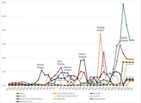
Figure
3: Sizes of largest polities in each of 10 world regions (square megameters): 1500 BCE- 2010CE
Figure 3 shows the sizes of the territories of the largest polities in each of our ten world regions from 1500 BCE until 2010 CE. There is the long-term trend toward larger polities in evidence in all the world regions, but also ample evidence of the patterns of rise and fall in each.
This graph is rather different from the one
produced by studying city sizes in all the regions (Chase-Dunn, Inoue, A. Alvarez, R. Alvarez, Anderson and
Neal 2015: Figure 3).
The
scale change for cities was far larger than the scale change for polities over
the last 3500 years. In 1500 BCE the largest city had only 75,000 people but by
2010 CE Tokyo had nearly 37 million people – a ratio increase of more than 492.
When we use the built-up area of cities the same scale change ratio for Thebes
and Tokyo is much greater (1696, see Table 1). But for polities the territorial size scale
change goes from .65 square megameters for the Theban
state to 17.1 square megameters for the Russian
Federation in 2010 CE. This is a scale
change ratio of only 26. The largest single formal empire ever was the British
Empire in 1900 CE with 29 square megameters of
territory, a ratio scale change of just 45 compared with Thebes in 1500 BCE. So
cities have grown much more than polities have over the last three and one half
millennia.
|
Scale Changes |
Largest City
(Population) |
Largest City (Built-up area) |
Largest Polity (Square Megameters) |
|
1500 BCE |
Thebes 75,000 |
8 km2 |
Thebes .65 |
|
2010 CE |
Tokyo 36,932,800 |
13,572 km2 |
Russian Federation
17.1 |
|
Scale change ratio |
492 |
1696 |
26 |
Table 1: Urban and Polity Territory Scale Changes, 1500 BCE to 2010 CE
The
city populations took off exponentially in the 19th century but the
polity sizes came down or leveled out because of collapse of the territorial
and colonial empires. Of course, as we have mentioned above, formal political
control over territory is not the only way that imperialism can be organized.
The extensive literature on neo-colonialism, hegemony and new forms of globalized
empire is germane here. But the overall trend toward larger formal states is
evident in the period since 1500 CE. It is hard to compare world regions when
we put them all in the same graph, but the strange trajectory of Central Asia
stands out in Figure 3, with the Mongol Empire showing itself as having been
the 2nd largest territorial empire in world history.
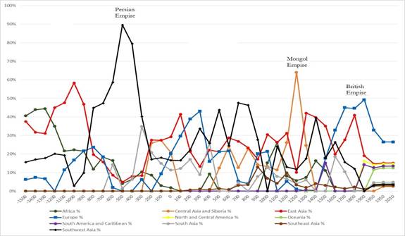
Figure
4: Percentage of each region held by its largest polity of the sum of the
largest polities in all ten regions
This
is what happens when we pit all the world regions against one another. The
percentages in Figure 4 are based on the denominator obtained by adding all the
territorial sizes in each of the regions together. We should note that our data
set is still not complete (see count of missing cases in Appendix), but the
main patterns displayed in Figure 4 will probably hold up when more estimates
are added. This a very complex set of patterns and it is hard to see what is
going on when we have all ten world regions. But some things jump out. The most obvious is
the 500 BCE overwhelming predominance of the Persian Empire in a period in
which the other regions had only small states.
We should remind the reader that we place an empire in its region
depending on where its capital is located.
So the Persians conquered Egypt, but Southwest Asia gets the points. Another interesting feature of Figure 4 is
what percentaging does to the relative standings of
the Mongol and British Empires. From the point of view of relative size, the
Mongols had a greater percentage than the British did, though neither come
close to the relative predominance of the earlier Persian Empire. Persia was
the proverbial 800 pound gorilla of the Central PMN.
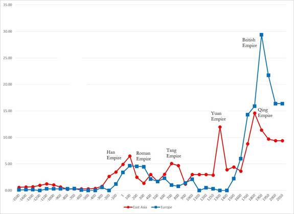
Figure 5: Sizes of largest
polities in Europe and East Asia (square megameters):
1500 BCE- 2010CE
Figure
5 has the same numbers as Figure 3 above but without including the other seven
world regions. This figure shows the
sizes of the largest states and empires in Europe and East Asia since 1500 BCE.
Again both regions show the overall long-term trend toward greater polity sizes
and also the sequences of shorter-term rises and falls. Of interest here are
the two great divergences discussed above and the issue of synchrony vs.
see-sawing. We also want to compare the East Asian trajectory with that of the
Central PMN as well as with Europe. When we look at Europe’s trajectory vis a
vis East Asia in Figure 5 we can see that the rise of the Han Empire in China
began earlier than the rise of large Macedonian and Roman empires in Europe and
the decline began earlier in East Asia than it did in Europe. This has
implications for Scheidel’s notion of the first
divergence because the waves of empire formation were not entirely synchronous.
China did it first, followed not long after by Europe. The European peak then
last rather longer that the Chinese peak did. This was what many have observed
as the unusually long tenure of the Roman Empire. Then Europe went into a long
slump while Tang China recovered. With regard to the second great divergence,
the territorial size trajectories imply something different from Gunder Frank’s notion of stable Chinese centrality and late
and unstable European predominance. The
new rise of Europe begins earlier than Frank claims (in the 15th
century, not in the 18th) and Qing China is also getting larger but
ends up only half as large as the British Empire.
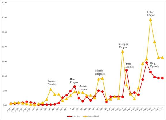
Figure 6: Sizes of largest
polities in East Asia and the Central PMN (square megameters):
1500 BCE- 2010CE
Figure
6 compares the largest polities in East Asia with those in the expanding
Central PMN. Recall that East Asia becomes part of the Central PMN in the
middle of the 19th Century CE but we can still compare the part with the whole
after that. Things look a bit different than when we compared with only the
“little West.” The Persian Empire, with its capital in Southwest Asia rises and
falls before the emergence of the Han. And the Islamic Empires are larger and
synchronous with the Tang. And since we have included Central Asia in the
Central PMN, the Mongol Empire appears just ahead of the very large Yuan Empire
which was, of course, founded by the Mongols. After 1500 CE the story is the
same as in Figure 6 because European powers, including the British Empire and
Russia, were the largest territorial polities. So Figure 6 seems to display
much more East/ “West” similarity than Figure 5 does.
The partial Pearson’s r correlation
coefficients among East Asia, Europe and the Central PMN are shown in Table 2.
|
Region or PMN |
Europe |
Central PMN |
East Asia |
|
Europe |
1 |
.78 sig = .000 |
.57 sig =.000 |
|
Central PMN |
.78 sig =.000 |
1 |
.51 sig =.001 |
|
East Asian Region and PMN |
.57 sig = .000 |
.51 sig = .001 |
1 |
Table 2: Pearson’s r
partial correlation coefficients (controlling for Year) for territorial
sizes of the largest polities in East Asia, Europe and the Central PMN from
1500 BCE to 2010 CE (n= 39)
Table 2 contains the correlation coefficients
produced by partial correlations in which year is held constant to control for
the long-term upward trend in the territorial sizes of polities. Unsurprisingly
given that Europe is an important part of the Central PMN, there is a .78
positive correlation across the 3500 year period studied. But somewhat more surprising
are the positive and statistically significant partial correlations between
Europe and East Asia and between the Central PMN and East Asia. Contrary to our examination of Figures 5 and
6 above, the partial correlation between the Central PMN and East Asia is
somewhat smaller than the partial correlation between Europe and East Asia.
Urban and Polity Conclusions
Our study of the largest cities in world
regions suggested problems with Andre Gunder Frank’s
(1998) characterization of the relationship between Europe and China before and
during the rise of European hegemony and the results of this study of largest
polities find the same things. Frank’s contention that Europe was primarily a
peripheral region relative to the core regions of the Afro-eurasian
world-system is supported by the city and polity data, with some
qualifications. Europe was for millennia
a periphery of the large cities and powerful empires of ancient Southwest Asia
and North Africa. The Greek and Roman cores were instances of semiperipheral marcher states that conquered important
parts of the older Southwest Asian/North African core. After the decline of the
Western Roman Empire, the core shifted back toward the East and Europe was once
again importantly peripheral. We find
partial support for Walter Schiedel’s idea of the
first great divergence between East and West after the decline of the Western
Roman Empire. Scheidel’s observation that the
Mediterranean was never again united as it had been under Rome is correct, but
the rise the Islamic Empires, part of the Central PMN was substantially
synchronous with the rise of the Tang dynasty in China. We also find more synchrony than the
see-sawing described by Morris, which would produce negative rather than
positive correlation coefficients.
Our
urban and polity synchrony findings support the idea proposed in Frank and
Gills (1994) that there was an integrated Afro-eurasian
world-system much earlier than most historians and civilizationists
suppose. But we cannot yet be certain that interaction networks were the
important causes of the synchrony and, if they were, we do not know which kind
of interactions were most important.
Counter
to Frank’s contention, however, the rise of European hegemony was not a sudden conjunctural event that was due solely to a developmental
crisis in China. The city population data indicate that an important renewed
core formation process had been emerging within Europe since at least the 14th
century. This was partly a consequence
of European extraction of resources from its own expanded periphery that is
seen in the expansion of the European colonial empires. But it was also likely
due to the unusually virulent form of capitalist accumulation within Europe,
and the effects of this on the nature and actions of states. The development of
European capitalism began among the city-states of Italy. It spread to the
European interstate system, eventually resulting in the first capitalist
nation-state (the Dutch Republic of the seventeenth century) as well as the
rise of the hegemony of the United Kingdom of Great Britain in the nineteenth
century. This process of regional core formation and its associated emphasis on
capitalist commodity production further spread and institutionalized the logic
of capitalist accumulation by defeating the efforts of territorial empires
(Hapsburgs, Napoleonic France) to return the expanding European core to a more
tributary mode of accumulation.
Acknowledging
some of the uniquenesses of the emerging European
hegemony does not require us to ignore the important continuities that also
existed as well as the consequential ways in which European developments were
linked with processes going on in the rest of the Afroeurasian
world-system.
The
more recent emergence of East Asian cities as again the very largest cities on
Earth occurred in a context that was structurally and developmentally distinct
from the militarily multi-core system that still existed in 1800 CE. Now there
is only one global core because all the core states are directly interacting
with one another. While the military multi-core system prior to the nineteenth
century was undoubtedly systemically integrated to an important extent by trade
and information flows, it was not as interdependent as the global world-system became
in the nineteenth century.
A new East Asian
hegemony is by no means a certainty, as both the United States and German-led
Europe will be strong contenders in the coming period of multi-polar hegemonic
rivalry (Bornschier and Chase-Dunn 1999; Chase-Dunn,
Kwon, Lawrence and Inoue 2011). The transition from territorial empires to
colonial empires and now to a global polity composed of formally sovereign
nation states has not ended the long evolutionary trend toward larger and
larger polities. This trend can continue to be seen in the trajectory of the increasing
size of the capitalist states that have assumed the role of leadership and
hegemony in the modern world-system, first the tiny Dutch Republic of the 17th
century, then the British Empire and now the continental-sized United States.
The forms of power have evolved, but uneven development and the processes of
rise and fall continue.
References
Abu-Lughod, Janet Lippman 1989. Before
European Hegemony The World System A.D. 1250-1350
New
York: Oxford University Press.
Amin,
Samir 1980. Class and Nation, Historically and in the Current Crisis. New York:
Monthly
Review Press.
Anderson, E. N. and Christopher Chase-Dunn “The
Rise and Fall of Great Powers” in
Christopher
Chase-Dunn and E.N. Anderson (eds.) 2005.
The Historical
Evolution of World-Systems. London: Palgrave.
Arrighi,
Giovanni 1994. The
Long Twentieth Century. London: Verso.
______________
2008 Adam Smith in Beijing. London:
Verso.
Arrighi, Giovanni, Takeshi Hamashita, and Mark Selden
2003 The Resurgence of East Asia :
500, 150 and 50 Year
Perspectives. London: Routledge
Barfield, Thomas J. 1989 The Perilous Frontier: Nomadic Empires and China. Cambridge, MA.:
Blackwell
Beaujard, Philippe. 2005 “The Indian Ocean in Eurasian and African
World-Systems Before
the
Sixteenth Century” Journal of World History 16,4:411-465.
_______________ 2009 Les mondes de l’océan
Indien Tome I: De la formation de l’État
au
premier système-monde
Afro-Eurasien (4e millénaire
av. J.-C. – 6e siècle apr. J.-C.).
Paris: Armand Colin.
_______________2010. “From
Three possible Iron-Age World-Systems to a Single Afro-
Eurasian
World-System.” Journal of World History
21:1(March):1-43.
_______________ 2112 Les mondes
de l’océan Indien Tome II: L’océan Indien, au coeur des
globalisations
de l’ancien Monde du 7e au 15e siècle. Paris: Armand
Colin
Beckwith,
I. Christopher. 1991. "The Impact of the Horse and Silk Trade on the
Economies
of T'ang China and
the Uighur Empire." Journal of the
Economic and Social History of the
Orient 34:2:183-198.
Bentley, Jerry H.
1993. Old World Encounters: Cross-Cultural Contacts and Exchanges in
Pre-
Modern Times. Oxford:
Oxford University Press.
Blanton, Richard E. , Stephen A. Kowalewski, and Gary Feinman. 1992.
"The Mesoamerican World-System." Review
15:3(Summer):418-426.
Bornschier, Volker and Christopher Chase-Dunn
(eds.) 1999 The Future of Global
Conflict London: Sage
Braudel, Fernand 1972 The
Mediterranean and the Mediterranean World in the Age of Philip II.
New
York: Harper and Row, 2 vol.
_____________. 1984. The Perspective of the World, Volume 3
of Civilization and Capitalism.
Berkeley: University of California Press
Chandler, David 1996 A History of Cambodia. Boulder, CO:
Westview Press.
Chase-Dunn,
C. 1988. "Comparing world-systems:
Toward a theory of semiperipheral
development," Comparative
Civilizations Review, 19:29-66, Fall.
Chase-Dunn, C and Thomas D. Hall
1993"Comparing World-Systems:
Concepts and
Working
Hypotheses" Social Forces
71:4(June):851-886.
____________________________1997 Rise and Demise: Comparing World-Systems
Boulder,
CO.: Westview Press.
Chase-Dunn, Christopher and Thomas D. Hall. 2011“East and West in world-systems
evolution” Pp. 97-119 in Patrick Manning and Barry K. Gills (eds.) Andre Gunder Frank and Global Development, London: Routledge.
Chase-Dunn, C. , Thomas D. Hall and Peter Turchin. 2007 “World-Systems in the Biogeosphere: Urbanization, State Formation, and Climate Change Since the Iron Age.” Pp.132-148 in The World System and the Earth System: Global Socioenvironmental Change and Sustainability Since the Neolithic, edited by Alf Hornborg and Carole L.
Crumley. Walnut Creek, CA: Left Coast Books.
Chase-Dunn,
Chris, Roy Kwon, Kirk Lawrence and Hiroko Inoue 2011 “Last of the
hegemons: U.S. decline and global
governance” International Review of Modern
Sociology 37,1: 1-29 (Spring).
Chase-Dunn, C. , Susan Manning and Thomas D.
Hall 2000 “Rise and fall: East-West
synchronicity
and Indic exceptionalism reexamined,” Social
Science History. 24,4:727-
754.
Chase-Dunn, C. and Andrew K. Jorgenson 2003 “Regions and Interaction Networks: an
institutional
materialist perspective,” International Journal of Comparative Sociology
44,1:433-450.
Chase-Dunn,
C. Eugene N. Anderson, Hiroko Inoue,
Alexis Álvarez, Lulin Bao,
Rebecca Álvarez,
Alina Khan and Christian Jaworski 2013 “Semiperipheral Capitalist
City-States and the Commodification of Wealth,
Land, and Labor Since the Bronze Age”
IROWS Working Paper #79 available at https://irows.ucr.edu/papers/irows79/irows79.htm
Chase-Dunn, C.
and Dmytro Khutkyy 2015 “The evolution of
geopolitics and imperialism
in interpolity
systems” IROWS Working Paper # 93
https://irows.ucr.edu/papers/irows93/irows93.htm
Chase-Dunn,
C and Bruce Lerro 2014 Social Change: Globalization from the Stone Age to the
Present. Boulder, CO: Paradigm
Chase-Dunn, C. Hiroko Inoue, Alexis Alvarez, Rebecca Alvarez, E.
N. Anderson and Teresa
Neal 2015 “Urban uneven development: largest
cities since the Late Bronze Age”
Presented
at the annual conference of the American Sociological Association, Chicago,
August 24, 2015. IROWS Working Paper # 98
https://irows.ucr.edu/papers/irows98/irows98.htm
Data appendix for this paper is at https://irows.ucr.edu/cd/appendices/worregs/worregsapp.htm
Chase-Dunn, C. David Wilkinson, E.N. Anderson,
Hiroko Inoue and Robert Denemark
2015
“Time-mapping globalization since the Bronze Age” IROWS Working Paper #
100 https://irows.ucr.edu/papers/irows100/irows100.htm
Chew,
Sing C. 2001 World ecological degradation : accumulation, urbanization, and
deforestation, 3000
B.C.-A.D. Walnut Creek, CA: Altamira Press
___________ 2007 The Recurring Dark Ages : ecological stress,
climate changes, and system
transformation Walnut Creek, CA: Altamira Press
___________ 2014 “The Southeast Asian connection in
the first Eurasian world economy,
200
BC- AD 500” Journal of
Globalization Studies,
Vol. 5 No. 1: 82–109
Coe, Michael D. 2003 Angkor and the Khmer Civilization. New
York: Thames and Hudson.
Ekholm, Kasja
and Jonathan Friedman 1982 “’Capital’ imperialism and exploitation in the
ancient world-systems” Review 6:1 (summer): 87-110.
Elvin,
Mark. 1973. The Pattern of the Chinese
Past. Stanford: Stanford University Press.
Fitzpatrick,
John. 1992. "The Middle Kingdom, the Middle Sea, and the Geographical
Pivot
of History." Review XV, 3 (Summer): 477-521
Flynn, Dennis O. 1996 World Silver and Monetary History in the 16th and 17th
Centuries.
Brookfield,
VT: Variorum.
Frank, Andre Gunder
1998 Reorient: Global Economy in the
Asian Age. Berkeley: University of
California
Press.
_________________ 2014 Reorienting the 19th Century: Global Economy in the
Continuing Asian
Age.
Boulder, CO: Paradigm Publishers.
Frank, Andre Gunder
and Barry Gills 1994 The World System:
500 or 5000 Years? London:
Routledge.
GeaCron World History Atlas & Timelines since 3000 BC . Luis Músquiz
http://geacron.com
Hall, Thomas D., Christopher Chase-Dunn and Richard Niemeyer. 2009 “The Roles of Central Asian Middlemen and Marcher States in Afro-Eurasian World-System Synchrony.” Pp. 69-82 in The Rise of Asia and the Transformation of the World-System,
Political Economy of the World-System Annuals. Vol XXX, edited by Ganesh K. Trinchur. Boulder, CO: Paradigm Press.
Honeychurch, William 2013 “The Nomad as State Builder: Historical Theory
and Material
Evidence from Mongolia” Journal of World Prehistory 26:283–321
Hui, Victoria Tin-Bor 2005 War and state Formation in Ancient China and Early Modern Europe. Cambridge: Cambridge University Press._________________ 2008 “How China was ruled” China Futures, Spring, 53-65Innis, Harold 1972 [1950] Empire and Communications. Toronto: University of Toronto Press.
Inoue, Hiroko 2014
“Settlement dynamics and empire dynamics: a comparative and
evolutionary world-systems perspective” Paper
presented at the annual meeting of
the American Sociological Association, San Francisco,
August 17.
Inoue,
Hiroko, Alexis Álvarez,
Kirk Lawrence, Anthony Roberts, Eugene N Anderson and
Christopher
Chase-Dunn 2012 “Polity scale shifts in world-systems since the Bronze Age:
A comparative inventory of upsweeps and
collapses” International Journal of
Comparative Sociology
http://cos.sagepub.com/content/53/3/210.full.pdf+html
Inoue, Hiroko, Alexis Álvarez, Eugene N. Anderson, Andrew Owen, Rebecca Álvarez, Kirk
Lawrence and Christopher Chase-Dunn 2015 “Urban scale shifts since the Bronze
Age: upsweeps, collapses and semiperipheral development” Social Science History Volume 39 number 2, Summer
Inoue, Hiroko Alexis Álvarez, E.N. Anderson, Kirk
Lawrence, Teresa Neal, Dmytro
Khutkyy, Sandor Nagy and Christopher Chase-Dunn 2013
“Comparing World-
Systems:
Empire Upsweeps and Non-core marcher states Since the Bronze Age”
https://irows.ucr.edu/papers/irows56/irows56.htm
Lattimore, Owen 1940 Inner Asian Frontiers of China. New York: American Geographical
Society.
Lenski,
Gerhard 2005 Ecological-Evolutionary Theory. Boulder, CO: Paradigm
Publishers
Lieberman, Victor. 2003. Strange Parallels: Southeast Asia in Global Context, c. 800-1830. Vol.
1:
Integration on the Mainland.
Cambridge: Cambridge University
Press.
______________ 2009. Strange
Parallels: Southeast Asia in Global
Context, c. 800-1830. Vol 2:
Mainland
Mirrors: Europe, Japan, China, South Asia, and the Islands. Cambridge:
Cambridge
University Press.
Liu,
Xinru and Lynda Norene
Shaffer. 2007. Connections across
Eurasia: Transportation,
Communication, and Cultural Exchange on the Silk Roads. New York:
McGraw-Hill.
Liverani, Mario 2013 The Ancient Near East. New
York: Routledge.
Mann,
Michael. 1986. The Sources of Social Power, Volume 1:
A history of power from the beginning
to A.D. 1760.
Cambridge: Cambridge University
Press.
McNeill,
John R. and William H. McNeill 2003 The Human Web. New York: Norton.
Modelski, George 2003 World
Cities: –3000 to 2000. Washington, DC:
Faros 2000
______________ Tessaleno
Devezas and William R. Thompson (eds.) 2008 Globalization
as
Evolutionary
Process: Modeling Global Change.
London: Routledge
Morris, Ian 2010 Why the West Rules—For Now.
New York: Farrer, Straus and
Giroux
______ 2013 The
Measure of Civilization. Princeton, NJ: Princeton University Press.
_______ and Walter Scheidel
(eds.) The Dynamics of Ancient Empires:
State Power from Assyria to
Byzantium. New York: Oxford
University Press.
Neal, Teresa 2013 “The Sasanian empire and world-systems Research” Working Paper,
Department of History, University of
California-Irvine
Pomeranz, Kenneth 2000 The Great Divergence: Europe,
China and the Making of the Modern World
Economy. Princeton: Princeton University Press.
Sanders,
William T., Jeffrey R. Parsons, and Robert S. Santley
1979 The Basin of Mexico:
Ecological Processes in the Evolution of a Civilization. New York: Academic
Press,
Scheidel, Walter
2009 “From the “great convergence” to the “first great divergence”:
Roman and Qin-Han state formation”
Pp. 11-23 in Walter Scheidel (ed.) Rome and
China: Comparative Perspectives on
Ancient World Empires.
New York: Oxford University
Press.
SESHAT :
The Global History Data Bank http://seshatdatabank.info/
____________
and Sitta Von Reden (eds.) The Ancient Economy. New York:
Routledge.
Sherratt, Andrew G. 1993a. "What Would a Bronze-Age World
System Look Like? Relations
Between Temperate
Europe and the Mediterranean in Later Prehistory."
Journal
of European Archaeology 1:2:1-57.
_____. 1993b.
"Core, Periphery and Margin:
Perspectives on the Bronze Age."
Pp. 335-345 in
Development
and Decline in the Mediterranean Bronze Age, edited by C. Mathers and S. Stoddart.
Sheffield:
Sheffield Academic Press.
_____. 1993c. "Who are You Calling
Peripheral? Dependence and Independence
in European
Prehistory." Pp.
245-255 in Trade and Exchange in
Prehistoric Europe, edited by C. Scarre and F.
Healy.
Oxford: Oxbow (Prehistoric
Society Monograph).
_____. 1993d. "The Growth of the Mediterranean
Economy in the Early First Millennium BC."
World Archaeology 24:3:361-78.
Schwartzberg, Joseph E. 1992 A Historical Atlas of South Asia New
York: Oxford
University Press. eMap :
Atlas : Document : English : 2nd impression. Chicago, Ill. :
Digital South Asia
Library, Center for Research Libraries
http://dsal.uchicago.edu/reference/schwartzberg/
Taagepera, Rein 1978a
"Size and duration of empires: systematics of size" Social Science
Research 7:108-27.
______
1978b "Size and duration of empires: growth-decline curves, 3000 to 600
B.C."
Social Science Research, 7
:180-96.
______1979
"Size and duration of empires: growth-decline curves, 600 B.C. to 600
A.D."
Social Science History
3,3-4:115-38.
_______1997
“Expansion and contraction patterns of large polities: context for Russia.”
International Studies Quarterly 41,3:475-504.
Tambiah, Stanley J. 1977 "The galactic
polity: the structure of traditional
kingdoms in
Southeast
Asia", Anthropology and the Climate of Opinion, Annals of the
New York
Academy of Sciences 293: 69–97
Teggart,
Frederick J. 1939 Rome and China: A Study
of Correlations in Historical Events Berkeley:
University of California Press.
Thompson,
William R and Kentaro Sakuwa
2013 “Was Wealth Really Determined in 8000 BCE,
1000 BCE, 0 CE, or Even 1500 CE? Another, Simpler
Look” Cliodynamics 4,1: 2-29
http://escholarship.org/uc/item/64q20336
Tilly,
Charles. 1990. Coercion,
Capital, and European States, AD 990-1990. Cambridge, MA:
Basil Blackwell
Turchin, Peter 2011 “Strange Parallels: Patterns in
Eurasian Social Evolution” Journal
of World Systems Research 17(2):538-552
Turchin, Peter, Jonathan M. Adams, and Thomas D. 2006.
“East-West Orientation of
Historical Empires and Modern States.” Journal of World-Systems Research. 12:2(December):218-229.
___________
and Sergey Gavrilets 2009 “The evolution of complex
hierarchical societies”
Social Evolution & History,
Vol. 8 No. 2, September: 167–198.
______________Thomas E. Currie, Edward A.L. Turner and Sergey Gavrilets 2013
“War, space, and the evolution of Old World complex societies”
PNAS October
vol. 110 no. 41: 16384–16389
Appendix: http://www.pnas.org/content/suppl/2013/09/20/1308825110.DCSupplemental/sapp.pdf
Turchin, Peter, Rob Brennan,
Thomas E. Currie, Kevin C. Feeney, Pieter François, Daniel
Hoyer, J. G. Manning, Arkadiusz Marciniak, Daniel
Mullins, Alessio Palmisano,
Peter Peregrine, Edward A. L. Turner, Harvey
Whitehouse. 2015.
“Seshat: The Global History
Databank” Cliodynamics 6: 77–107
Wallerstein, Immanuel 2011 [1974] The Modern World-System, Volume 1.
Berkeley: University
of
California Press.
Wilkinson, David 1987 "Central
Civilization." Comparative
Civilizations Review 17:31-59.
______________1991 "Core, peripheries and
civilizations." Pp. 113-166 in Christopher
Chase-Dunn
and Thomas D. Hall (eds.) Core/Periphery
Relations in Precapitalist Worlds,
Boulder,
CO.: Westview.
_______________1992a "Decline phases in
civilizations, regions and oikumenes." A paper
presented
at the annual meetings of the International Studies Association, Atlanta,
GA. April 1-4.
______________ 1992b "Cities,
civilizations and oikumenes:I." Comparative Civilizations
Review 27:51-87 (Fall).
_______________ 1993 “Cities, civilizations and
oikumenes:II”
Comparative Civilizations
Review 28: 41-72.
_______________2004 The Power Configuration Sequence of the
Central World System, 1500-700 BC
Journal of World-Systems Research Vol. 10, 3.
Wilkinson, Toby C., Susan Sherratt and John
Bennet 2011 Interweaving Worlds: Systemic
Interactions in
Eurasia, 7th to
1st Millennia BC. Oxford: Oxbow Books.
Wohlforth, William
C., Richard Little, Stuart J. Kaufman, David Kang, Charles A Jones,
Victoria Tin-Bor Hui, Arther Eckstein, Daniel Deudney and William L Brenner 2007
“Testing balance of
power theory in world history” European
Journal of
International Relations 13,2:
155-185.
Wolf , Eric
1997 Europe and the People Without
History, Berkeley: University of
California
Press.
Wong,
R. Bin 1997 China Transformed: Historical
Change and the Limits of European Experience.
Ithaca: Cornell University Press.
Endnotes