Settlement Networks and
Sociocultural Evolution
Elizabeth Bogumil
and Christopher Chase-Dunn
Sociology, University of California-Riverside
Edward
Elgar Handbook on Cities and Networks
Editors: Zachary Neal, Michigan State University and Celine Rozenblat, University of Lausanne
v. 8/27/18 11342 words This is IROWS Working Paper #127 at https://irows.ucr.edu/papers/irows127/irows127.htm
Abstract: Settlement
networks provide a fundamental window on human social structures and their
connections with the biosphere. We present an overview of the roles that human
settlement interaction networks have played in the sociocultural evolution of
human societies since the Paleolithic Era using the comparative world-systems
perspective. We also summarize research
on the location and timing of changes in the scale of settlements and polities
since the Bronze Age, the emergence of the contemporary global city system and
discuss possible futures for the city of humans.
Keywords: world-system,
sociocultural evolution, settlement, interaction networks, cities, comparative
Anthropologists and historical
comparative social scientists have seen value in understanding not only how
different locations and cultures are distinct but also where and when sociocultural
complexity and hierarchy have emerged over the past twelve thousand years. Knowledge
of where and when the sizes of human settlements[1] have
changed over time is useful for testing aspects of general models of
sociocultural evolution.[2] This
chapter examines the roles of settlement networks in sociocultural evolution using
the comparative world-systems perspective. The first section focuses on settlements,
and the interaction networks built amongst them, before the emergence of states.
The second section describes how interaction networks were involved in the rise
and fall of large settlements and polities and in the emergence of settlements
that were larger than any that had existed before. The third section discusses
the early emergence of cities and states in Mesopotamia, Egypt, the Indus River
Valley, the Yellow River Valley, Mesoamerica and the Andes. And the expansion
of empires and their building of empire cities. The fourth section considers
the emergence and spread of semiperipheral capitalist
city-states and their roles in the construction of commodity trade networks and
the spread of commercializations networks in
world-systems in which state power and tributary accumulation remained the main
instruments of reproduction. And then we consider how the emergence of the
Europe-centered capitalist world-system drove and was driven by the
establishment of core world cities and dependent colonial cities. Finally, we conclude by providing an overview
of the implications of research on the evolution of settlement systems for
understanding the contemporary global system of city-regions and possible futures
for the world city system.
Anthropological and World Historical
Frameworks of Comparison
The emergence of sedentism, the
growth of settlements and interaction networks among settlements and polities[3]
are fundamental processes of social change that required the invention of
institutions that could facilitate cooperation and enable polities to
effectively compete with one another for resources, including territory. The
study of settlement size distributions – the relative sizes of interacting
settlements – within polities and in networks of independent interacting
polities -- provides another important window for viewing and comprehending the
emergence and growth of human organizational complexity and hierarchy.
An anthropological and world
historical framework of comparison allows us to study the evolution of
small-scale (prestate) polities as well as the
emergence and growth of cities and the rise of more hierarchical of settlement-size
distributions. Ethnographers and archaeologists
have studied small-scale nomadic polities of foragers (hunter-gatherers). All
humans lived in small-scale nomadic polities until about 12.000 years ago.
Nomadic foragers lived in temporary camps, but they tended to follow yearly
migration circuits that brought them back to the same seasonal locations, and
so they too had “settlement systems” in the sense that they utilized
geographical space in a patterned way. About 11,000 years ago nomadic foragers in
the Levant (present day Lebanon) began staying longer in winter hamlets. This was the beginning of sedentism. Termed the
“Natufian culture” by archaeologist, these first sedentary people gathered
natural stands of grain that grew in the rain-watered valleys of the Levant and
stored this food so that they could remain in one location through the winter.
These were the first villagers on earth. They were not horticulturalists. They
were sedentary hunter-gatherers, and polities of this kind continued to exist
in certain locations, such as California, until they were colonized by the
expanding modern world-system in the 18th and 19th
centuries of our era. An anthropological
framework of comparison allows us to analyze the settlements systems of nomads
and the emergence of sedentism and the roles that nomads and small-scale polities
and interaction networks have played in the emergence of larger settlement
systems based on horticulture and agriculture. But in order to
comprehend the long-term processes of the development of complexity and
hierarchy we need to combine the study of small-scale systems with a world
historical framework that examines regional systems in which cities
(settlements with at least 50,000 residents) emerged. This occurred in
Mesopotamia and Egypt in the early Bronze Age and these civilizations also invented
writing, so now we have both archaeological and documentary evidence for
studying them.
The Comparative Evolutionary World-Systems
Perspective
Chase-Dunn and Hall (1997) reconfigured
the world-system perspective that had emerged to study the modern global system
(Hall et al. 2013; Shannon 1992) to compare
spatially small world-systems with medium-sized regional systems and the
now-global world-system of today. They defined world-systems as systemic interaction
networks that link settlements and polities in reciprocal interaction webs
(networks) that condition the reproduction and change of local social
structures.[4] The word “world” here refers to the world of
real interactions (trade, warfare, communications, intermarriage) that
reproduce the social structures and institutions of human groups. In this sense
“worlds” were small when transportation and communication technologies imposed
a tyranny of distance that constrained the consequences of interaction to
extend relatively short distances. These were the small social worlds in which
people lived (see also Chase-Dunn and Mann 1998 and Chase-Dunn and Lerro 2017).
Chase-Dunn and Hall (1997) noted that
different kinds of systemic interaction often have different spatial scales in
small and medium-sized world-systems. Bulk goods (food) networks were usually
smaller than political/military networks in which independent polities were
making war and security alliances with one another. And, these
political/military networks were smaller than prestige goods trade networks in
which goods that were very valuable relative to their weight were traded in
down-the-line[5] exchange networks or
carried by long-distance traders. The
spatial bounding of world-systems must choose a focal locale and then use the
principal of “fall-off” to determine the distances from that point to the outer
edge of the interaction system (Renfrew 1975, 1977). This is usually at most
two or three indirect (non-contiguous) links. The important point here is that
the networks in which individual settlements are linked with other settlements
typically cross the borders between independent polities (
and so they are “international.”)
Once one has
spatially bounded the interaction networks starting from a focal settlement,
then the issue of core/periphery relations can be examined. The modern core/periphery hierarchy is often
discussed in terms of the Global North and the Global South. World-systemists see the Global South as being composed of small,
poor and relatively powerless peripheral countries in Africa, Asia and Latin
America and larger semiperipheral countries (i.e. Mexico,
Brazil, China, Indonesia, India, Russia), or smaller countries at middle levels
of economic development (i.e. Taiwan, South Korea, Israel, South Africa) that
are in the modern semiperiphery. The core is composed
of most of the national societies in Europe and North America, but also Japan
and Australia. But core/periphery relations may also be studied in earlier
world-systems.[6] Chase-Dunn and Hall (1997)
distinguish between “core/periphery differentiation,” which exists when
polities with different degrees of population density[7]
systemically interact with one another, and “core/periphery hierarchy” which
exists when some polities exploit and dominate other polities. Chase-Dunn and
Hall (1997: Chapter 5) also propose that the phenomenon of “semiperipheral
develop” is an important cause of sociocultural evolution in which polities in semiperipheral positions often are the agents of increases
in the scale and complexity of world-systems.
Human settlements
before the rise of states
As we have said
above, the anthropological framework allows us to study the “settlement
systems” of nomads. Nomads do not wander aimless across the face of the
Earth. They move to most easily obtainable
and desireable food, water and other necessities.
They harvest nature, but nature is seasonal and the
harvesting depletes some of the resources that are being taken. The hunting of
big game depletes the local supply and so it is easier to move the camp than to
travel long distances to hunt. Camps are the settlements of nomadic peoples.
And seasonal migration routes are their patterned settlement systems. Camps and migration circuits are the
patterned ways in which nomads utilize space in socially constructed ways (Dodgshon 1987). Archaeologists
have discovered that seasonal migration circuits became smaller as the
population density of North American nomadic foragers rose (Fagan 1991; Nassany and Sassaman 1995) in the
transition from Paleoindian big game hunters to Archaic hunters who were still nomads
but were hunting smaller types of game (see Figure 1). The Archaic nomadic bands developed spear
point styles that were distinctive from those of their neighbors, whereas Paleo
spear points were much more similar across wide regions of North America.
Nassaney and Sassaman (1995) suggest that these regional
tool kit distinctions mean that the Archaic bands were forming distinct local
and regional cultural identities.
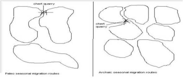
Figure 1: Paleo and Archaic
migration circuits
The shorter
migration circuits were a step on the way to sedentism in which nomadic bands
move down the food chain from hunting large game to relying on smaller game
(which depletes more slowly) and on more vegetable foraging. Population density
(the number of people per area of land) went up and resource use became more
diversified. Both nomadic and sedentary foragers are known to have used fire to
increase the growth of food-producing plants and grazing areas attractive to
game. This kind of activity has been called “protoagriculture”
(Bean and Lawton 1976).
The First Villagers
It is
commonly believed that all hunter-gatherers were nomadic and that sedentism
emerged with horticulture during the “Neolithic revolution.” But this is wrong.
Sedentism emerged before horticulture and sedentary foraging societies survived
into recent centuries in certain ecologically abundant locations such as
California and the Pacific Northwest. Some hunter-gatherers in prime
environments figured out how to exploit less vulnerable natural resources such
as seeds, tubers, small game, and fish. They were able to live much of the year
in semi-permanent winter villages without depleting the environment. These
Mesolithic diversified foragers moved to other locations during the summer for
seasonal hunting or gathering. Some of
the population of the winter villages moved to seasonal camps during the spring
and summer. Thus, the emergence of sedentism that began with the transition to
smaller seasonal circuits continued in small steps until the winter village
became the permanent home of most of the population. The transition from
nomadism to sedentism was a matter of seasonal camps becoming occupied for
longer and longer periods of time, and with some of the population remaining,
while others went off to other locations during special seasons. The earliest
sedentary societies were of diversified foragers in locations in which nature
was bountiful enough to allow hunter-gatherers to feed themselves all year without
migrating. These early villagers continued to interact with still-nomadic
peoples in both trade and warfare. This was the first instance of
core-periphery differentiation.
In many Mesolithic world-systems the largest villages had only
about 250 people. In other regions there were larger villages, and regions with
different population densities were often in systemic interaction with one
another (Chase-Dunn and Mann 1998). Settlement size hierarchies emerged when a
village at a crucial location, often located at the confluence of two streams,
became the home place of important personages and the location of larger non-residential
ritual spaces such as sweat lodges. Sedentary foragers developed long-distance trading
networks, and the shift from nomadism to sedentism can be understood as a
transition from a system in which people
moved to resources to one in which resources were moved to people.
The spatial network aspects of this transition are interesting. As
we have seen above in the description of the emergence of smaller seasonal
migration circuits and regionally differentiated tool styles, nomadic systems
went from spatially very large (in the sense that people used larged territories on a part-time basis, to smaller, and to
very small with the emergence of sedentism. But the settlement systems of
sedentary peoples began again to get larger if we consider the rise of trade
networks that emerged to link settlements that were distant from one another
(see Figure 2). Exchange between settements and
polities allowed for the emergence of greater population density because
villagers were able to obtain needed food during periods of scarcity without
resorting to the raiding of neighboring settlements for supplies. These reciprocal exchange networks grew and
grew, though they also occasionally shrank, repeating pattern that Chase-Dunn
and Hall (1997) have called “oscillation.” Eventually, the systemic
interaction networks became global (Earth-wide) in extent, and it is then that
we call them globalization. So networks first shrank
with the coming of sedentism, and then expanded again to eventually become
completely global with the arrival of intercontinental oceanic voyaging.
Figure 2: Spatial networks shrank and then expanded with the emergence of sedentism
Sedentism
also increased the population growth rate because village life was much more
conducive to child-rearing than was the life of nomads. Families
living in permanent villages could afford to have more closely spaced children
than nomadic peoples could manage (McNeill and McNeill 2003).
This
speeded up the repeated emergence of population pressure on resources which was
a major driver of sociocultural evolution (Kirch 1984,
2017; Johnson and Earle 1987).
The Hilly Flanks
Sedentism arose in multiple locations
throughout the world, which had no known interaction or communication with each
other. This is an example of parallel or
convergent evolution in which somewhat similar circumstances led to somewhat similar
developmental outcomes. It was in regions adjacent to those that first
developed sedentary diversified foraging that Neolithic horticulture first
emerged. In the Levant it was neighbors
of the Natufians who occupied less naturally fecund upland valleys that first
went to the trouble of planting fields of grain (Moore 1982).
When the nomadic foragers
in neighboring areas tried to emulate the sedentary life-style of the Mesolithic
villagers, they found that their less abundant natural stands of grain were
quickly eaten up. To increase the productivity of their lands they experimented
with planting some of the seeds that they had gathered. This intervention
in nature’s production of food resources increased the productivity of land, but required more labor. It allowed more people to be
fed per area of land, once again increasing population density (Hayden
1981). This emergence of horticulture in the “hilly flanks” near the
earlier emergence of sedentary foragers was an early instance of semiperipheral development in which jealous hill dwellers were
willing to work harder to catch up with neighboring village-living low landers.
The emergence of horticulture was a
continuation of the trend from large nomadic circuits to smaller circuits to
sedentism and then to intensified production. Horticulture allowed villages to
be larger in population size. As with sedentism, horticulture emerged
independently in at least eight world regions, another instance of parallel
evolution.
The next steps in intensification of
production and the emergence of yet larger settlements occurred with the
formation of chiefdoms on the Susiana Plain (in what is now Iran) that used
small-scale irrigation systems to increase the productivity of agriculture. The
organization and coordination of irrigation projects is favored by the
emergence of hierarchy within polities, as has been shown in a recent study of
155 small-scale polities in Austronesia (Sheehan et al. 2018). But the first chiefdoms on Earth were in a region in
the fertile crescent not far from where sedentism and horticulture had first
emerged. The rise of chiefdoms produced the first two-tiered settlement size
hierarchies.
Settlement Size Hierarchies
The spatial aspect of population density is one of the most
fundamental variables for understanding the constraints and possibilities of
human social organization. The “settlement size distribution”—the relative
population sizes of the settlements within a region—is an important and easily
ascertained aspect of all sedentary social systems. And, the functional
differences among settlements are a basic feature of the division of labor that
links households and communities into larger polities and interpolity
networks. The emergence of social hierarchies is often related to and inferred
from the size hierarchy of a set of settlements. The building of monumental
architecture in larger settlements has been closely associated with the
emergence of more hierarchical social structures—complex chiefdoms and early
states.
The spatial relationships among settlements in a region and their
relative sizes can be infered from archeological evidence,
and so this is an empirically useful pattern that allows us to compare
preliterate systems with those for which we have documentary evidence. Figure 3
below shows Hans Nissen’s drawings of 1-tiered (a), 2-tiered (b), 3-tiered (c)
and 4-tiered (d) settlement size hierarchies.
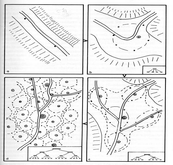
Figure 3:
Settlement size hierarchies (Nissen 1988:42)
Settlement
size distributions are often graphed to show the relative population sizes of
the settlements in a region. Figure 4 shows a steep settlement size
distribution in which the largest settlement is much larger than the second
largest, and a flat distribution in which all the settlements are about the
same size. Urban geographers suggest that a spatial size hierarchy is often
related to the distribution of functions across settlements and transportation
costs (Christaller 1966). Production of goods and
services that can easily be distributed across a whole region from a
central place will tend to be located in the largest
settlement, whereas products that cannot easily be stored or transported will
be produced locally in the smaller settlements. The “range of goods” creates
the space economy. This approach was developed to describe market societies, but is also relevant for understanding settlement
systems in which exchange was organized as reciprocity, because transportation
costs and labor time had to be considered in the effort to be generous.
Urban
geographers contend that there is a tendency for settlement size hierarchies to
approximate a rank-size or lognormal size distribution. A rank-size
distribution exists when the 2nd largest settlement is ½ the
size of the largest, the 3rd largest is 1/3 the size of the
largest, etc. A lognormal distribution is similar in shape. It exists when the
ranked population sizes of settlements in a region fall on a straight line when
the population sizes have been transformed to a logarithmic scale. “Urban
primacy” is said to exist when the largest city in a region is larger than
would be expected based on the rank-size or lognormal distributions – larger
than twice the size of the second largest settlement. Empirical studies have
shown that many settlement size hierarchies do approximate the rank-size rule,
but some are flat (as with a 1-tiered size distribution) and many are primate
(e.g. Chase-Dunn 1985).
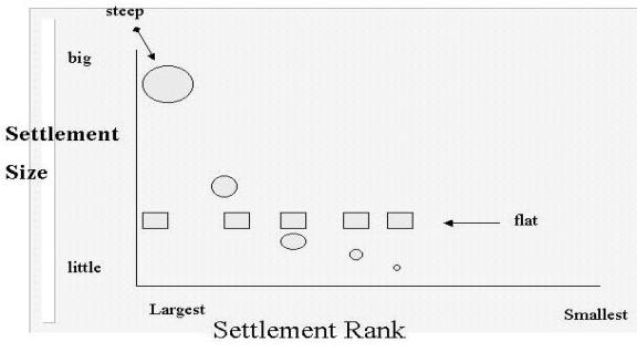
Figure 4: Flat and
steep settlement size distributions
The
rise of cities and states
The original gardening (horticulture) in the Levant spread both
west into the valley of the Nile and east toward Mesopotamia. Larger villages
and towns emerged in rain-watered regions and population growth led to the
migration of farmers away from the original heartland of gardening.
Horticultural techniques also diffused from group to group and were combined
with the domestication of pigs, sheep, and goats. Domestication of animals and
the use of dairy products and meat from domesticated animals eventually made it
possible to move a few notches back up the food chain, reversing some of the
descent that had followed the depletion of big game. Still-nomadic hunter-gatherers
traded with the Neolithic towns, and new forms of specialized pastoral nomadism
developed based on the herding of domesticated animals in areas that were
adequate for pasture but not for farming.
The simple model here is that technological development (planting
and animal husbandry) increased population density and this facilitated the
emergence of larger settlements and social hierarchies. McNeill and McNeill
(2003) noted that state formation in East Asia followed the spread of rice
cultivation (e.g. from China to Korea to Japan). They contend that storable and
tradable grain is far more conducive to state formation than are crops that are
not easily stored (such as yams).[8] But
there is evidence from the Chesapeake region of indigenous North America that the
adoption of planting of storeable food does not
always immediately lead to greater complexity and hierarchy (Chase-Dunn and
Hall 1999).
The arrival of maize planting in the Chesapeake region allowed the
formerly Mesolithic diversified foragers living in rather large villages to redisperse into widely spread farmsteads and to reduce the
intensity of their trading and ritual symbolization of group identity and
social hierarchy. So, increasing productivity can, under some conditions, lead
to deconcentration and less social
hierarchy. The ability to produce a surplus does not automatically lead to
hierarchy formation. Surplus production must be possible in
order to support non-producers, but hierarchy formation tends to occur
when population pressures have led to increasing levels of conflict. In the
case of the Chesapeake, the arrival of maize reduced population pressure and so
those hierarchies and larger villages that had already emerged went into
decline. It was not until population pressure had returned after a period of
population growth and increasing competition for land that villages and
hierarchies grew again. New hierarchies emerged to regulate access to scarce
resources and to reduce the intensity of conflict (Chase-Dunn and Hall 1997: Chapter
6).
As villages eventually grew larger, so did trade networks. Craft
specialists began producing for export and importing raw materials. Trade
networks expanded and intensified, but not permanently. All networks exhibited
a pattern of expansion and contraction (oscillation), and these waves were
punctuated by occasional upward sweeps that connected much larger regions. Thus,
the waves of globalization and deglobalization that have been shown to have
occurred in the last 150 years (Chase-Dunn, Kawano and Brewer 2000), are only
the most recent and largest instances of a much older pattern of exchange network
expansion and contraction.
To the Flood Plain
According to Nissen (1988: Chapter 3) the first three-tiered
settlement system in Southwest Asia emerged on the Susiana Plain (in what is
now in Iran adjacent to the Mesopotamian flood plain) during the Ubaid period
(5500-4000 BCE). This would indicate the presence of complex chiefdoms,
and Wright (1986) points to the importance of the existence of complex
chiefdoms in a region as the necessary organizational prerequisite for the
emergence of pristine states (states that emerge in a context in which there
have been no previous states). In other words, the first states did not emerge
directly from egalitarian societies. Evidence from Uqair,
Eridu and Ouelli shows that
there were also Ubaid sites on the Lower Mesopotamian flood plain that were as
large as the sites on the Susiana Plain. The Early Ubaid phase at Tell Ouelli shows remarkably complex architecture as early as
anything on the Susiana Plain. Thus, there was an interregional exchange and
warfare network of chiefdoms based on a mix of rain-watered and small-scale
irrigated agriculture. This was the context in which cities and states first
emerged on Earth.
In the next period (Uruk or Late
Chalcolithic from 4000-3100 BCE) the first true city (Uruk)
grew up on the floodplain of lower Mesopotamia, and other cities of similar
large size soon emerged in adjacent locations. Uruk
had a peak population of about 50,000. Surrounding these unprecedentedly
large settlements were smaller towns and villages that formed the first
four-tiered settlement systems (Adams 1966). Other cities soon emerged on
the floodplain constituting a world-system of city-states. For seven centuries
after the emergence of Uruk, the Mesopotamian
world-system was an interactive network of city-states competing with one
another for land, glory and for control of the complicated transportation
routes that linked the Mesopotamian floodplain with the peoples and natural
resources of adjacent regions.
Mesopotamia was the original heartland of “civilization”
understood as the combination of irrigated agriculture, writing, cities, and
states. States also emerged somewhat later in the Uruk
period on the Susiana Plain (Wright 1998) and these also developed four-tiered
settlement systems (Flannery 1998:17). This was an instance of uneven development --
the transition from an inter-regional interchiefdom
system to an inter-city-state system that emerged first in Mesopotamia and then
spread to the adjacent Susiana plain.
Both cities and states got larger with the development of social
complexity, but they did not grow smoothly. Rather there were cycles of growth
and decline and sequences of uneven development in all the regions of the world
in which cities and states emerged. It was the invention of new techniques of
power, production and exchange that ultimately made possible the more complex
and hierarchical societies that emerged. The processes of uneven development by
which smaller and newer semiperipheral settlements
overcame and transformed larger and older ones has been a fundamental aspect of
sociocultural evolution since the invention of sedentary life. And sociocultural
evolution is somewhat analogous to ecological succession. Higher levels of
complexity cannot emerge directly out of low levels. Production of surplus and
the formation of chiefdoms must form the “institutional soil” out of which
state formation can grow. But states do not form automatically. They are the
products of human innovation in a situation in which they have been made
possible by earlier developments, and in which they can solve problems that are
posed under current conditions. Thus, there is a degree of historical
contingency and agency in the process, and this is very evident in the pattern
of semiperipheral development, because it is not all semiperipheries that transform the systems of which they
are a part.
Sedentary/Nomadic Coevolution
Sedentary societies interacted with still-nomadic societies from
the beginning of sedentism. The original
core/periphery division of labor was between sedentary and nomadic foragers. As
sedentary societies developed horticulture, they also domesticated both plants
and animals, especially in ancient Southwest Asia and Egypt. Domesticated wheat
and barley retain their grains longer and are easier to harvest than the wild
varieties. Foragers had lived with dogs for millennia, but goats, sheep, pigs,
cattle, donkeys, horses and cattle were domesticated by either sedentary
peoples, or by nomadic peoples who became pastoralists in interaction with
sedentary farmers. Archaeologists have studied farmer-forager interactions in
many contexts (e.g. Gregg 1988, 1991). Nomadism co-evolved with sedentism, a
process most famously described for East and Central Asia by Owen Lattimore
(1940) where Central Asian steppe nomads became specialists in the herding of
sheep and horses, trading meat and animals with farmers along the steppe
frontier. Nomadic pastoralists played an important role in the formation of
sedentary states and empires because they not only supplied meat and animal
products, but they soon underwent political evolution as well. The Central
Asian steppe nomad confederacies were able to mobilize large cavalries to
attack agrarian empires, and they both pillaged and extracted tribute in a
process most clearly described by Thomas Barfield (1989). It was also former
nomadic pastoralists who formed sedentary semiperipheral
states on the edges of old core regions, and who were often the protagonists of
empire formation when they conquered adjacent core states. Thus, the dynamics
of sedentary/nomadic relations played an important role in the evolution of the
tributary modes of accumulation – the uses of institutionalized coercion to
structure a system of hierarchical exploitation and domination.
Power and size: cities and empires
What is
the relationship between the sizes of settlements and power in intergroup
relations? Under what circumstances does a society with greater population
density have power over adjacent societies with lower population density, and
when might this relationship not hold? Population density is often
assumed to be a sensible proxy for relative societal power. Indeed, Chase-Dunn
and Hall (1997) employ high relative population density as a major indicator of
core status within a world-system. But Chase-Dunn and Hall are careful to
distinguish between “core/periphery differentiation” and “core/periphery
hierarchy.” Only the latter constitutes actively employed intersocietal
domination or exploitation, and Chase-Dunn and Hall warn against inferring
power directly from differences in population density.
In many world-systems, military superiority is a key dimension of intersocietal relations. Military superiority is generally
a function of population density and the proximity of a large and coordinated
group of combatants to contested regions. The winner of a confrontation is that
group that can bring the larger number of combatants together quickly.
This general demographic basis of military power has been transformed by
military technology, including transportation technologies. Factors such as
better weapons, better training in the arts of war, faster horses, better
boats, greater solidarity among soldiers and their leaders, as well as
advantageous terrain, alter the simple correlation between population size and military
power.
Ironically, George Modelski’s (2003)
important study of the growth of world cities completely ignored the growth of
states and empires, though Modelski is himself an
astute scholar of international relations and geopolitical power. Modelski contended that cities were the most important
driving force of world system evolution and that we may conveniently ignore
states and empires. The relationship between political power and settlements
itself evolved over the millennia, so that analysis of the relationship between
size and power is necessary to understand what happened.
The most important general exception (in comparative evolutionary
perspective) to the size/power relationship is the phenomenon of semiperipheral development mentioned
above. The pattern of uneven development by which formerly more complex polities
lost their place to “less developed” polities has taken several forms depending
on the institutional terrain on which interpolity
competition was occurring. Less relatively dense semiperipheral
marcher chiefdoms often conquered older core chiefdoms to create larger paramount
chiefly polities (Kirch 1984). Likewise, semiperipheral marcher states, usually recently settled
peripheral peoples out on the edge of an old region of core states, frequently were
the agents of a new core-wide empire based on conquest (Mann 1986; Turchin 2003).
Another exception is the phenomenon of semiperipheral
capitalist city-states –polities in the spaces between tributary empires and
states that specialized in long-distance trade and commodity production.[9]
Though these were rarely the largest cities within the world-systems dominated
by tributary empires, they played a transformational role in the expansion of
production for exchange and commodification in the ancient and classical world-systems.
And, less dense semiperipheral Europe was the locus
of a virile form of capitalism that condensed in a region that was home to many
unusually proximate semiperipheral capitalist
city-states. This development, and the military technology that emerged in the
competitive and capitalist European interstate system, made it possible for
less dense Europe to erect a global predominance over the more densely
populated older core regions of Afroeurasia
(Chase-Dunn and Hall 1997; Chase-Dunn and Lerro 2016).
The more recent hegemonic ascent of formerly semiperipheral
national states such as England and the United States are further examples of
the phenomenon of semiperipheral development.
The phenomenon of semiperipheral
development does not totally undermine the proposition that societal power and
demographic size are likely to be correlated. What it implies is that this
correlation can be overcome by other factors, and that these processes are not
entirely random. Denser core polities are regularly overcome or out-competed by
less dense semiperipheral polities, but it does not
follow that all semiperipheral or peripheral regions
have such an advantage. On the contrary, in most world-systems most low-density
polities are subjected to the power of more dense polities. Semiperipheral development is a rather important exception
to this general rule.
Why should a settlement system have a steeper size distribution
when there is a greater concentration of power? The simple answer is that large
settlements, and especially large cities, require greater concentrations of
resources to support their large populations. Therefore, population size has
itself been suggested as an indicator of power (Morris 2010, 2013; Taagepera, 1978: 111). But these resources may be
obtainable locally and the settlement size hierarchy may simply correspond to
the geographical distribution of resources. People cluster near oases in a
desert environment. In such a case it is not the political or economic power of
the central settlement over surrounding areas that produces a centralized
settlement system, but rather the geographical distribution of necessary or
desirable resources (water). In many systems, however, we have reason to
believe that relations of power, domination and exploitation do affect the
distribution of human populations in space. Many large cities are as large as
they are because they can draw upon far-flung regions for food and raw
materials. If a city can use political/military power or economic power to
acquire resources from surrounding cities, it will be able to support a larger
population than the dominated cities can, and this will produce a hierarchical settlement
size distribution.
Of course, the effect can also go the other way. Some cities can
dominate others because they have larger populations, as discussed above. Great
population size makes possible the assembly of large armies or navies, and this
may be an important factor creating or reinforcing steep settlement size
distributions.
The relationship between power and settlement systems is
contingent on technology as well as political and economic networks manifested
through their institutions. Thus, the relationship between urban growth and
decline sequences and the growth/decline sequences of empires varies across
different systems or in the same regional system over time as new institutional
developments emerge. We know that the development of new techniques of power,
as well the integration of larger and larger regions into systems of interaction,
production and trade, facilitate the emergence of larger and larger polities as
well as larger and larger cities. Thus, there has been a secular trend at the global level
and within regions between settlement sizes and polity sizes over the past six
millennia.
Studies of the relationship between the rise and fall of empires
and the growth/decline phases of the largest cities in the same regions have
found differences in the temporal relationship between the growth and decline
of largest cities and largest empires. Partial correlations that take out the
long-term trend show that the medium-term relationship between city and empire
growth is significantly positive in Mesopotamia (2800 BCE-650 BCE), South Asia
(1800 BCE-1500 CE), and Europe (430 BCE-1800 CE), but not in Egypt, West Asia,
and East Asia (Chase-Dunn, Alvarez, and Pasciuti
2005: Table 5.2). In the regions in which there are significant correlations
this is sometimes due to the big empires building their own big capital cities,
but at other times a big city appears that is outside of the largest empire.
This suggests that regions go through general phases of expansion and
contraction in which both cities and empires grow and then decline, and this
supposition is confirmed by the finding in all regions of high partial
correlations between the growth/ decline phases of largest and second largest
cities (Chase-Dunn, Alvarez, and Pasciuti 2005: Table
5.3). And, rather surprisingly, there is a similar set of significant positive
partial correlations in all five regions studied between the growth/decline
phases of largest and second largest empires (Chase-Dunn, Alvarez, and Pasciuti 2005: Table 5.4). This latter is surprising
because territorial growth is a zero-sum game among adjacent empires, and yet
the medium-term temporal correlations are positive, indicating that empires get
larger and smaller together within regions. This is strong evidence that
regions experience cycles of growth and decline that affect both cities and
states.
We should also note an important finding reported in Gilbert Rozman’s (1973) comparison of the rise of cities in Japan
and China. Rozman notes that in China early dynasties
built large primate capitals in a context of agricultural villages, but it took
2000 years for this to evolve into a log-normal city-size distribution with
middle-sized cities performing intermediary roles linking the capital with the villages.
In Japan the process started later but the emergence of middle-sized cities
occurred much more quickly because the Japanese adopted the Chinese
organizational and institutional feature that facilitated the emergence of
middle-sized cities.
To better understand the timing and
location of scale changes in the sizes of cities, George Modelski
(2003) improved Tertius Chandler’s (1987) compendium of the population sizes of
largest cities since the Bronze Age.[10]
Studies of the populations sizes of the largest cities in world regions show
that there have been cycles in which the largest city in each region increased
in size and then decreased in size and these cycles were punctuated by
occasional upsweeps in which the largest city increased to a size that was a
lot bigger than that of the earlier size peaks.[11] From
studies of the growth and decline of large cities Modelski
(2003) and Fletcher (1995) both noticed the emergence of size ceilings before
an upsweep to the next larger ceiling. Fletcher contended that, in addition to
resource constraints on the sizes of settlements, large settlements require the
invention of institutions that allow large numbers of people to live close to
one another. Settlement sizes increased when one polity in a region figured out
how to make a large city work, and then other polities in adjacent regions copied,
and sometimes improved upon, these techniques and so their cities were able to
catch up in size with the earlier large city. A size ceiling was reached because of both resource
and institutional constraints.
The SetPol Research Working Group has identified
those instances in which the scale of cities significantly changed (upsweeps
and downsweeps) (Inoue et al. 2015)
and has begun testing the hypothesis that these scale changes were caused
by semiperipheral marcher states
(Inoue et al. 2016). In
our studies of upsweeps and non-core (peripheral and semiperipheral)
marcher states we examined four regional world-systems (Mesopotamia, Egypt,
East Asia, and South Asia) as well as the expanding central political/military network
that is designated by David Wilkinson’s (1987) temporal and spatial bounding of
state systems since the Bronze Age. We found that nine of the eighteen urban upsweeps
we studied were produced by noncore marcher state conquests and eight directly
followed, and were caused by, upsweeps in the territorial sizes of polities
(Inoue et al. 2015). Whereas about half of the
upsweep events were caused by one or another form of non-core development,
there were a significant number of upsweep events in which the causes seem to
be substantially internal to the polity that carried out the upsweep (Inoue et
al. 2016). Another important finding is that collapses, in
which the largest settlements in a region go down below the level of the
earlier trough, and stay down for a long period, are rather rare. Individual
cites collapse, but systems of cities rarely do.
The modern world city network
The problem of sustainable urbanization is crucial for the human
encounter with the consequences of our ballooning environmental footprint (Gruebler and Buettner
2013). Over half of the human
population of the Earth now lives in very large cities, and these have spread
rapidly over the land as population densities within cities have decreased
(suburbanization) and cities have become interconnected into huge city-regions.
The size hierarchy of world cities has been flattening as megacities in the
non-core countries have caught up in terms of overall population size with the
global cities of the core. This flattening has important implications for
theories of urban growth, globalization and the future of global
inequalities. This section considers the conceptualization of world
cities and city-regions and the idea of a global system of cities. We shall
consider the global city-size distribution and the implications of its
flattening for the question of the limits of settlement size and the problems
of how to spatially bound cities and city-regions. And, we further discuss the
emergence of low density and multicentric cities.
The role of city systems in
the reproduction and transformation of human social institutions was altered by
the emergent predominance of capitalist accumulation. Whereas most of the
important cities of agrarian tributary states were centers of control and coordination
for the extraction of labor and resources from vast empires by means of
institutionalized coercion, the most important cities in the modern world have
increasingly supplemented the coordination of force with the manipulations of
money and the production of commodities. Many of those
who studied the
early modern world-system noted the importance of cities as primary nodes
through which goods and services flowed and the importance of finance capital
and its relationship with state power in the core (Arrighi
1994; Braudel 1984).
The
long rise of capitalism was promoted by semiperipheral
capitalist city-states, usually maritime coordinators of trade protected by
naval power. The Italian city-states of Venice and Genoa are perhaps the most
famous of these, but the Phoenician city-states of the Mediterranean exploited
a similar interstitial niche within a larger system dominated by tributary
empires. These capitalist trading
city-states rewired, expanded and intensified the existing networks of
exchange. The niche pioneered by capitalist city-states expanded and became
more predominant in the guise of core capitalist nation-states in a series of
transformations from Venice and Genoa to the Dutch Republic (led by Amsterdam)
and eventually the Pax Britannica coordinated by the great
world city of the nineteenth century, London (Chase-Dunn and Willard 1994). Thus,
did capitalism move from the semiperiphery to the
core, constituting a world-system in which the logic of profit making had
become more important than the logic of tribute and taxation. In 1900 CE London
was still the largest world city, but New York was coming up fast (see Figure 5).
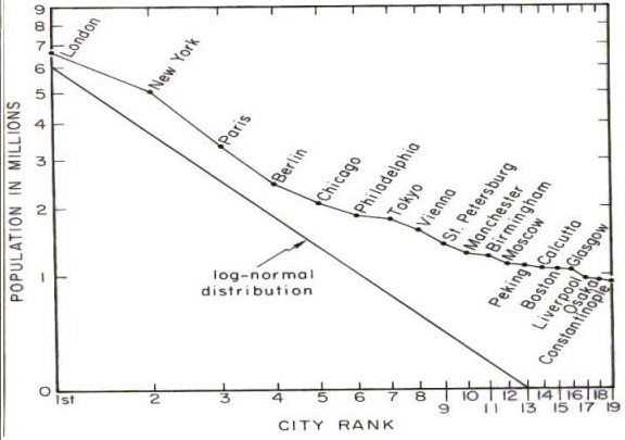
Figure 5: The world city size distribution in
1900 CE
Within London the political and financial functions were spatially
separated: empire in Westminster and money in the City. In the twentieth century
hegemony of the United States these global functions became located in separate
cities (Washington, DC and New York). Thus, the role of cities in
world-systems changed greatly as capitalism became the predominant mode of
accumulation over the last 500 years. In the tributary world-systems
the biggest cities were the capitals of empires based on their ability to
extract resources using institutionalized coercion (armies, bureaucracies,
etc.) Capitalist cities existed, but they were in the semiperipheral
interstices between the large tributary empires. With the rise of Europe,
capitalist cities became the most important cities in the whole world-system.
Amsterdam, London and New York have been the global centers of the modern
world-system.
But the relationship between power and size continued to operate
(until recently) in the modern system. Figure 6 displays changes in the settlement
size distribution of the largest cities in the European-centered world-system
since 800 CE (Chase-Dunn and Willard 1994). The city size distribution of
interstate systems is almost always flatter than the size distributions of
settlements within a single polity, because the multicentric political
structure of interstate networks affects the size distribution of settlements
(e.g. Figure 5). Figure 6 uses the “Standardize Primacy Index,” a measure of
deviation from the lognormal rule (Walters 1985). The Europe-centered city system was never
steeper than the lognormal distribution and it was occasionally much flatter.
The periods of flatness mainly correspond with times of political
decentralization in which there was the absence of a hegemonic core power
(Chase-Dunn and Willard 1994). The descent into city-size flatness that began
in the last half of the 20th century has continued since then.
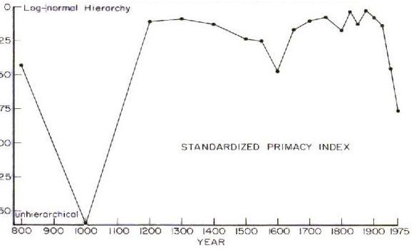
Figure 6: Changes in the city-size distribution
of the Europe-centered system, 800 to 1975 CE
World cities and the global settlement system
According to the theorists of global capitalism it was during the
1970’s that the world-system entered a new period in which the system’s
structure was qualitatively altered by the rise of the neoliberal globalization
project (Castells 1996; Robinson 2014). This new model of development
displaced the Keynesian national development model that had been hegemonic
since World War II. Neoliberalism attacked, and tried to dismantle, the
institutions of reformed capitalism that had been built in response to the
World Revolution of the 1917 – the welfare state, labor unions that had
succeeded in obtaining middle class incomes for primary sector workers,
progressive tax policies, controls on currency manipulations and capital flows,
and public education institutions that had expanded access to formerly excluded
groups. The neoliberals used advantages stemming from new information and
communication technologies to financialize and globalize the world economy,
with the export of manufacturing jobs from the core to the semiperiphery
and periphery and the rise of global cities exercising economic power over the
global economy (Sassen 1991). John Friedmann’s (1986)
“world city hypothesis” identified a set of world cities and the contradictory
relations globalized production and management and the territorialized political
networks of the international system of states.
Although
the global city network in recent decades is hierarchical, with “world cities”
at the top (Friedmann 1986; Sassen 2001), according
to Alderson and Beckfield (2007) this hierarchy does
not exactly mirror the tripartite core/periphery hierarchy because the world city network
became partially decoupled from the geopolitical network of states over the
course of 20th
century globalization. But, contrary to the
neo-liberal claim that there is now a level
playing field (Friedman 2006), the structure of the world city system network
has not become less hierarchical across the era of globalization (Alderson and Beckfield 2007). In fact, the world city network became
more unequal when some cities such as New York, London, and Tokyo gained more
control over the finances of the world economy relative to other megacities
such as those in Latin America (Timberlake and Smith 2012).
Saskia Sassen and others have further developed
the global city hypotheses. Global cities acquired new functions beyond acting
as centers of international trade and banking. They became: (1) concentrated
control locations in the world-economy that use advanced telecommunication
facilities, (2) important centers for finance and specialized producer service
firms, (3) coordinators of state power, (4) sites of innovative post-Fordist
forms of industrialization and production, and (5) markets for the products and
innovations produced (Brenner 2004; Sassen 2006).
These structural shifts in the functioning of cities “impacted both the
international economic activity and urban form where major cities concentrate
control over vast resources, while financial and specialized service industries
have restructured the urban social and economic order” (Sassen
1991: 4). During the 1990’s New York became specialized in equity trading,
London in currency trading and Tokyo in large bank deposits (Slater 2004).
Beaverstock, Smith and Taylor
(1999) and Taylor (2003) used Sassen’s focus on
producer services to classify 55 alpha, beta and gamma world cities based on
the presence of office networks and headquarters of accountancy,
advertising, banking/finance and law firms (see Figure 7.)
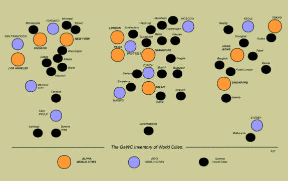
Figure 7: Alpha, beta and gamma world
cities according (Beaverstock, Smith and Taylor 1999)
The hierarchy of global cities shown in Figure 7 provides an
important insight into the world settlement system that has emerged in the
period of neoliberal global capitalism. Though the world city-size distribution
based on the population sizes of the largest cities has flattened since 1950,
this has not produced a flat globalized world in which a core/periphery
hierarchy no longer exists. Rather the world cities of the Global North
continue to concentrate the command and control functions of the world economy,
while joined to some extent by megacities in the rising countries of the semiperiphery in Asia and Latin America and including a
third tier of megacities in peripheral countries -- huge metropoli
containing vast numbers of recent migrants from the country-side who subsist in
informalized slums lacking regular employment and urban services (Davis 2006). [12]
Much of the research on the global city system and affiliated
networks has been based on case studies of individual cities that seek to
identify the processes leading to their emergence and positioning within the
larger system. Janet Abu-Lughod (1999) traced the
developmental histories of New York City, Chicago, and Los Angeles through
their upward mobility in the world city system (see also Taylor and Lang 2005) While these U.S. metropoles share similar
characteristics with other world cities, they have substantial differences in
geography, original economic functions, transportation, and political history that
make the stories of each fascinating instances of globalization and local
peculiarities (see also Davis 1992).
City
Regions
Another
phenomenon of recent urbanization is the emergence of city-regions, large areas
in which big cities are located rather closely to one-another and intervening
areas are mainly suburbanized. Urban geographers have noted that populations in
the rural areas and small towns of core countries are thinning and people are
concentrating in these city regions (Scott 2001; Simmonds and Hack 2000; Segbers 2007). The city region phenomenon is made plain by observing
global maps that show city lights at night produced from satellite and shuttle
images (see Figure 8).
All
the continents have city regions, but the largest are those found in the
eastern half of the United States and the western portion of Europe, with
several other regions also displaying this phenomenon. These city regions are
linked together spatially by overlapping suburban areas.
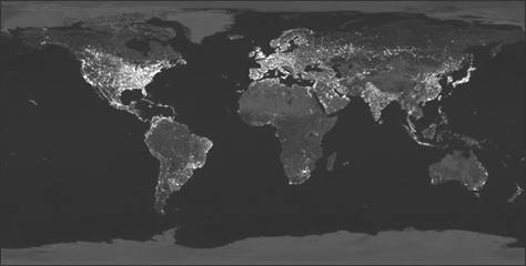
Figure 8: City lights photographed from satellites and shuttles
The
flattening of the global city-size distribution since 1950, shown in Figure 6
above, has several causes. As in earlier periods, the city-size distribution
became less hierarchical (flatter) during times in which a global hegemon was
in decline. The cities of challenging powers grow, and the cities of the former
hegemon cease to grow as fast. The recent descent into flatness of the world city size
distribution is partly due to the declining hegemony of the United States and
the rise of challengers with very large cities. Many of the world’s largest
cities are now in the semiperiphery and the periphery.
Changes the city-size distribution reflect to
some extent changes in the distribution of economic and political/military
power. The flattening since the 1950s is partly due to the rapid growth of
large cities in Japan and China. But megacities in the Global South have also
grown greatly during the period of recent globalization. As mentioned above,
these megacities in non-core countries are very different animals, despite
their large size. The neoliberal structural adjustment policies of the
International Monetary Fund, which were part of the globalization project,
imposed austerity on countries of the Global South and encouraged large-scale
export agriculture that drove small farmers from the land into the Planet of Slums (Davis 2006). Another factor that accounts for cities in
the Global South catching up with core cities in population size has to do with
differences in the demographic transition. Most core countries have achieved a
replacement fertility rate, but most of the Global South still has a higher
fertility rate and faster population growth, boosting the growth of megacities.
Roland Fletcher (personal communication) contends that
contemporary institutional and infrastructural inventions only allow for
megacities to function at maximum populations of around twenty million and this
serves as a kind of ceiling effect which has allowed cities in the Global South
to catch up in terms of population size with the largest cities in the core
states. Fletcher’s notion of an upper limit on the size of large cities may
also be part of the explanation for the emergence of city-regions rather than
gigacities.
The
size and density of city-regions are related to global differences in the level
of economic development. The global city-region-size hierarchy is related to differential
economic and political/military power. Countries in the periphery have
succeeded in producing very large megacities, but their city-regions are not as
large and dense as those in the core (see Figure 8 above).
The future city of humans
Over
half of the 7.6 billion people on Earth now live in cities. The low-density
suburban sprawl that has taken over the process of urban growth in the core is
immensely expensive in terms of resource use. Urbanization has a huge direct
effect on the environment, as cities absorb heat from the sun and then release
it, and humans use great amounts of energy in cities, which contributes to
global warming. The “urban heat island,” in which urban regions are hotter than
surrounding areas because of energy usage and because building materials absorb
more heat from the sun (Sailor 2011), is an important phenomenon that is
contributing to warming.
While many core cities have deindustrialized, large cities
in the semiperiphery have industrialized and are now
the new sites of intense labor struggles (Silver 2003). The global “reserve
army of labor” (rural people still not employed in the formal economy) is still
large but the long-run tendency for wages, materials and taxes to rise will likely
resume and continue, eventually causing a crisis for capitalist accumulation
(Wallerstein 2003). The expansion of the sharing economy during the neoliberal
crackdown on wages will also challenge the logic of capitalism (Mason 2015).
Peter Taylor (2003) contends that globalization has decreased the
importance of nation-states and increased the importance of cities, and that
this may be a good thing because cities are more easily governable by
communities of citizens. Human settlement systems have been strongly involved
in the processes of sociocultural evolution for thousands of years as both
cybernetic nodes of innovation, and in the processes of uneven development that
have led to the rise and fall of states, empires and modern hegemons. Regarding
the latter, we can expect that new forms of governance relevant to solutions of
the emergent problems of the twenty-first century may be invented and
implemented in the cities of the Global South, especially Brazil, India, Mexico
and China. Curitiba, Brazil has already successfully demonstrated a new form of
sustainable urbanism that will become increasingly relevant as the natural
resources that have been the basis of urban sprawl become further depleted
(Rabinowitz and Leitman 1996). The Pink Tide left
populist regimes that emerged in Latin America in reaction to neoliberal
globalization (Rodrik 2018) were important supporters of transnational global
justice movements that have contested neoliberal global governance and pushed
toward a new kind of globalization from below. The cities of the Global
South remain fertile spaces for finding solutions for our increasingly
urbanized planet.
The world settlement system has become a network of large cities
and city regions that contain over half of the human population. There are
immense inequalities between those powerful global cities that control global
financial and military apparatuses that affect everyone and the huge cities of
the Global South that face growing problems of poverty, disease and insecurity.
The modern world-system has, over the past several centuries, exhibited cycles
of globalization (Chase-Dunn, Brewer, and Kawano 2000), the rise and fall of
hegemonic core powers, and upward trends in population growth and economic
development. The massive global inequalities that emerged during the 19th
century have not been reduced despite the rapid economic development of India and China (Bornschier 2010).
The three
main challenges of the 21st century are:
addressing
huge environmental issues and moving in the direction of sustainable
development; and
addressing
the issue of huge inequalities between the global North and South.
restructuring
global governance to prevent a recurrence of warfare among the great powers and
to improve the capacity for managing the other two challenges.
All the large cities of the world will be affected by the timing
and rapidity of these emerging crises and so a plan for restructuring the
global system to more effectively meet these challenges is greatly
needed. The strengthening and democratization of the United Nations would enhance
global cooperation for meeting these challenges and for supporting the
empowerment of the peoples of the world.
Bibliography
Abu-Lughod, Janet Lippman. 1999. New
York, Chicago, Los Angeles: America’s Global Cities. Minneapolis, MN:
University of Minnesota Press.
Adams, Robert McCormick. 1966. The Evolution of Urban Society: Early
Mesopotamia and Prehispanic Mexico. Chicago: Aldine.
Adams, Robert McCormick and Hans J. Nissen. 1972.
The Uruk
Countryside: The Natural Setting of Urban Societies. Chicago:
University of Chicago Press.
Alderson, Arthur S. and Jason Beckfield.
2007. “Globalization and the World City System:
Preliminary
Results from a Longitudinal Data Set.” Pp. 21-35 in Theories Peter J. Taylor, Ben Deruder,
Pieter Saey and Frank Witlox,
eds., Cities in Globalization: Practices,
Policies and. London: Routledge Taylor and Francis Group.
Anderson, E. N. 2019 Mandate of Heaven. Berlin: Springer VerlagArrighi, Giovanni. 1994. The Long Twentieth Century: Money, Power, and the Origins of Our Time. London:
Verso.
Bar-Yosef, O. and Belfer-Cohen,
A. 1991. “From Sedentary Hunter-gatherers to Territorial Farmers in the Levant.”
Pp 181-202 in S.A. Gregg, ed., Between
Bands and States. Carbondale: Center for Archaeological Investigations,
Occasional Papers #9.
Bean, Lowell John and Harry Lawton. 1976.
"Some Explanations for the Rise of Cultural Complexity in Native
California with Comments on Proto-Agriculture and Agriculture." Pp. 19-48 in Lowell John Bean and Thomas C.
Blackburn, eds., Native Californians: A Theoretical Retrospective. Socorro, NM: Ballena Press.
Beaverstock, J.V., P.J. Taylor
and R.G. Smith. 1999. “A roster of world cities.” Cities 16:
445-458.
Bornschier, Volker. 2010. “On the
evolution of inequality in the world system” Pp. 39-64 in
Christian Suter ed., Inequality Beyond Globalization. New
Brunswick, NJ: Transaction
Publishers.
Bosworth, Andrew. 2000. “The Evolution of the World
City System, 3000 BCE to AD
2000.” In Jonathan Friedman, Barry K. Gills, and
George Modelski Robert A. Denmark eds., World System History: The Social Science of
Long-Term Change. New York: Routledge.
Braudel, Fernand.
1984. Civilization and Capitalism 15th
-18th Century Volume III The Perspective of
the World. London: Collins.
Brenner, Neil. 2004. New
State Spaces: urban governance and the rescaling of
statehood. New York: Oxford
University Press.
Bruegmann, Robert. 2008. Sprawl. Chicago: The University of
Chicago Press.
Chandler, Tertius. 1987. Four thousand years of urban
growth. Lewiston, N.Y.: St. David's University Press.
Castells, Manuel. 1996. The
Rise of the Network Society. Cambridge, MA: Blackwell.
Chapman. A.C. 1957. “Ports of Trade Enclaves in Aztec and
Maya Civilizations” Pp. 114-153 in K. Polanyi, C. Arensberg, and
H. Pearson, eds., Trade and Markets in
the Early Empires. Chicago: Henry Regnery.
Chase-Dunn, Christopher. 1985. “The coming
of urban primacy in Latin America” Comparative
Urban Research, 11(1-2):14-31.
Chase-Dunn,
Christopher, Alexis Alvarez, and Daniel Pasciuti.
2005. "Power and Size; urbanization and empire formation in
world-systems" Pp. 92-112 in C. Chase-Dunn
and E.N. Anderson, eds., The
Historical
Evolution of World-Systems. New York: Palgrave.
Chase-Dunn, Christopher. and Hall T.D. 1991. “Conceptualizing
Core/Periphery Hierarchies for Comparative Study” Pp 1-44 in C. Chase-Dunn and
T.D. Hall, eds., Core-Periphery Relations
in Precapitalist Worlds. Boulder: Westview Press.
________________________ .1997. Rise and Demise: Comparing World-Systems. New York: Routledge.
________________________. 1999. “The Chesapeake world-system:
complexity, hierarchy and pulsations of long range
interactions in prehistory.” Presented at the annual meeting of the American
Sociological Association http://wsarch.ucr.edu/archive/papers/c-d&hall/asa99b/asa99b.htm
Chase-Dunn, Christopher., Yukio Kawano and Benjamin Brewer.
2000. “Trade globalization since 1795: waves of integration in the
world-system.” American Sociological Review 65(1): 77-95..
Chase-Dunn, Christopher. and
Bruce Lerro. 2016. Social Change:
Globalization From the Stone Age to the
Present. New York: Routledge
Chase-Dunn, Christopher and Kelly M. Mann. 1998 The Wintu and Their Neighbors: A Small
World-System in Northern California, University of Arizona Press.
Chase-Dunn, Christopher. and Susan Manning. 2002. “City systems and
world-systems” Cross-
Cultural Research
36 (4): 379-398. https://irows.ucr.edu/research/citemp/ccr02/ccr02.htm
Chase-Dunn, Christopher. and Willard, A. 1994. Systems of
Cities and World-Systems. [online] Irows.ucr.edu. Available at: https://irows.ucr.edu/papers/irows5/irows5.htm.
Chase-Dunn, C. and Alice Willard 1994 "Cities in the
Central Political-Military Network Since CE
1200" Comparative
Civilizations Review, 30:104-32 (Spring) 1994.
Chase-Dunn, Christopher., Kawano, Y. and Brewer, B. 2000. “Trade
Globalization since 1795: Waves of Integration in the World-System” American
Sociological Review, 65(1), p.77.
Christaller, Walter. 1966. Central Places in Southern Germany.
Englewood Cliffs, N.J.: Prentice-Hall.
Collins, Randall. 1978. "Some Principles of Long-term Social
Change: The Territorial Power of
States." Pp. 1-34 in Louis F. Kriesberg, ed., Research in Social Movements, Conflicts and Change,
Volume 1, Greenwich, CT: JAI Press.
______________. 1992.
“The Geographical and Economic World-Systems of Kinship-Based and
Agrarian-Coercive Societies.” Review 15(3):373-88.
Davis, Mike. 1992. City of Quartz: Excavating the future in Los Angeles. New York:
Vintage.
_________2006.
Planet of Slums. London: Verso.
Dezzani, Raymond J., and Christopher Chase-Dunn. 2010. “The Geography of
World Cities.” Pp. 2969–2986 in Robert A. Denemark,
ed., The International Studies
Encyclopedia, Chichester, UK: Wiley-Blackwell.
Dodgshon, R. A. 1987. The European Past: Social Evolution and
Spatial Order. London: MacMillan.
Fagan, Brian. M. 1991. Ancient
North America. New York: Thames and Hudson.
Feuerstein, G., Kak S. and
Frawley D. 1995. In Search of the Cradle
of Civilization: New Light on Ancient India. Los Angeles: Quest Books.
Flannery, Kent V.
1998. “The ground plans of archaic states.” Pp. 15-57 in G. Feinman
and J. Marcus,
eds., Archaic
States. Santa Fe, NM: School of American Research.
Fletcher, Roland. 1995. The Limits of Settlement Growth: A Theoretical Outline. Cambridge:
Cambridge University Press.
Friedman,
Thomas L. 2006. The World is Flat: A Brief History of the Twenty-first Century. New
York:
Farrar, Straus, & Giroux.
Friedmann, John. 1986. “The World City Hypothesis.” Development and Change 17(1): 69-83.
Garreau, J. 2011. Edge City: Life on the New Frontier. New
York: Random House.
Gregg, Susan A. 1988. Foragers and Farmers: Population Interaction and Agricultural
Expansion in Prehistoric Europe.
Chicago: University of Chicago
Press.
____________, ed.
1991. Between Bands and States.
Center for Archaeological Investigations, Occasional Paper #9, Carbondale,
IL.: Southern Illinois University.
Hall, Thomas D., Christopher
Chase-Dunn, and Hiroko Inoue. 2013. “Wallerstein, Immanuel.” Pp. 909-012 in McGee,
R. Jon and Richard L. Warms, eds., Theory in Social and Cultural
Anthropology, Vol. 2. Thousand Oaks, CA. Sage Publications. https://irows.ucr.edu/papers/irows125/irows125.htm
Inoue, Hiroko, Alexis Álvarez, Eugene N.
Anderson, Andrew Owen, Rebecca Álvarez, Kirk Lawrence, and
Christopher Chase-Dunn. 2015, “Urban scale shifts since the Bronze Age:
upsweeps, collapses and semiperipheral development.” Social
Science History 39
(2): 175-200.
Inoue, Hiroko, Alexis Álvarez, E.N. Anderson,
Kirk Lawrence, Teresa Neal, Dmytro Khutkyy,
Sandor Nagy, Walter DeWinter, and
Christopher Chase-Dunn. 2016. "Comparing World-Systems: Empire Upsweeps and
Non-core marcher states Since the Bronze Age" http://ierows.ucr.edu/papers/irows56/irows56.htm
Jones, Gareth Stedman. 1971. Outcast London: A Study in the Relationship between Classes in Victorian
Society Oxford: Clarendon.
Johnson, A.W. and Earle T. 1987. The Evolution of Human Societies: From Foraging Tribe to Agrarian State.
Stanford: Stanford University Press.
Kirch, Patrick V. 1984. The Evolution of Polynesian Chiefdoms.
Cambridge: Cambridge University Press.
_____________ 2017 On
The Road of the Winds: An Archaeological History of
the Pacific Islands Before European Conquest. Berkeley: University of
California Press.
Lattimore, Owen.
1940. Inner Asian Frontiers of China. New York: American
Geographical Society,
republished 1951, 2nd ed. Boston: Beacon Press.
Lenski G. and J. Lenski, ed. 1987. Human Societies. New York: McGraw-Hill.
Lightfood, K. G. and Feinman G.M. 1982. “Social Differentiation and Leadership
Development in Early Pithouse Villages in the Mogollon
region of the American Southwest”. American
Antiquity, 47(1): 64-86.
Linduff, K.M. 1998. “The
Emergence and Demise of Bronze-Producing Cultures Outside the Central Plains of
China” Pp. 619-643 in V. Mair, ed., The
Bronze Age and Early Iron Age Peoples of Eastern Central Asia. Volume 2.
Washington, D.C.: The Institute for the Study of Man.
Mason, Paul. 2015. Postcapitalism
New York: Farrer, Straus and Giroux.
McNeill, J. and McNeill W.H. 2003. The Human Web. New York: Norton.
Modelski, George. 2003 World Cities: -3000 to 2000. Washington, DC: Faros 2000
Moore, A. M.T. 1982. “The First Farmers in the Levant” Pp.91-112
in Young, Smith, and Mortenson, eds., The
Hilly Flanks and Beyond: Essays on the Prehistory of Southwestern Asia.
Chicago: University of Chicago Press.
Morris, Ian. 2010. Why the West Rules – For Now. New York: Farrer,
Straus, and Giroux.
Morris, Ian. 2013. The Measure
of Civilization. Princeton, NJ: Princeton University Press.
Nassaney, Michael S. and Kenneth E. Sassaman, eds. 1995. Native
American Interactions: Multiscalar Analyses and Interpretations in the Eastern
Woodlands. Knoxville: University of Tennessee Press.
Neitzel, Jill E. (ed.) Great
Towns and Regional Polities in the Prehistoric American Southwest and Southeast.
Albuquerque: University of New
Mexico Press.
Nissen, H. J. 1988. The
Early History of the Ancient Near East, 9000-2000 B.C. Chicago: University
of Chicago Press.
Piketty, Thomas. 2014. Capital in the 21st Century.
Cambridge, MA: Harvard University Press.
Puett. M. 1998. “China in Early Eurasian
History: A Brief Review of Recent Scholarship on the Issue.” Pp.699-715. in V.
Mair, ed., The Bronze Age and Early Iron
Age Peoples of Eastern Central Asia. Volume 2. Washington D.C.: The
Institute for the Study of Man.
Rabinovitch, Jonas and Josef Leitman. 1996. “Urban Planning in Curitiba.” Scientific
American 274(3).
Renfrew, Colin R.
1975. "Trade as Action at a Distance: Questions of Integration and
Communication." Pp. 3-59 in J. A. Sabloff and C. C. Lamborg‑Karlovsky,
eds., Ancient Civilization and Trade. Albuquerque, NM: University of New Mexico Press.
____________.
1977. "Alternative Models for Exchange and Spatial
Distribution." Pp. 71-90 in T. J.
Earle and T. Ericson, eds., Exchange
Systems in Prehistory,. New York:
Academic Press.
Revere, R.B. 1957. “No Man’s Coast: Ports of Trade in the
Eastern Mediterranean.” Pp.38-63 in K. Polanyi, C. Arensberg,
and H. Pearson, eds., Trade and Markets
in the Early Empires. Chicago: Henry Regnery.
Robinson, W. I.
2014. Global Capitalism and the Crisis of Humanity. Cambridge:
Cambridge University
Press.
Rodrik, Dani. 2019. “Populism and the economics
of globalization.” Journal of
International Business
Policy 1: 12-33.
Rozman, Gilbert. 1973. Urban Networks in Ching China and Tokugawa
Japan. Princeton, NJ:
Princeton
University Press.
Sailor, D. J. (2011). "A review of methods for
estimating anthropogenic heat and moisture emissions
in the urban
environment" International Journal of Climatology 31,2: 189–199
Sassen, Saskia. 1991. Global Cities. Princeton, NJ:
Princeton University Press.
_______________. 2006. Territory, Authority, Rights: from
medieval to global assemblages. Princeton, NJ: Princeton University Press.
Scott,
Allen J., ed. 2001. Global City-Regions:
trends, theory, policy. New York: Oxford
University
Press.
Segbers,
Klaus, ed. 2007. The Making of Global City Regions: Johannesburg, Mumbai,
Sao Paulo and Shanghai. Baltimore, NJ: Johns Hopkins University Press.
Shannon, T. R. 1992. An
Introduction to the World-systems Perspective. Boulder: Westview Press.
Sheehan,
Oliver, Joseph Watts, Russell D. Grey, and Quentin D. Atkinson. 2018.
“Coevolution of landesque capital intensive
agriculture and sociopolitical hierarchy.” PNAS 115(14): 3628-3633.
Silver, Beverly J. 2003. Forces of labor: workers'
movements and globalization since 1870. Cambridge: Cambridge
University Press.
Simmonds,
Roger and Gary Hack. eds. 2000. Global city regions: their
emerging forms.
London:
Spon
Slater, Eric. 2004. “The flickering
global city,” Journal of World-Systems Research 10,3: 591-608
(Fall)
Smith, David A. and
Michael Timberlake. 2001. “World City Networks and Hierarchies, 1977-1997: An
Empirical Analysis of
Global Air Travel Links.” American Behavioral Scientist 44,
10: 1656-1678.
Stone,
D. 2017. “Where Your ‘Made In China’ Trinkets Are Actually Made”
National Geographic.
[online] Available at: https://www.nationalgeographic.com/photography/proof/2017/09/yiwu-china-commodities-market/
[Accessed 3 Feb. 2018].
Taagepera, Rein. 1978. "Size and duration of empires:
growth-decline curves, 3000
to
600 BC" Social Science Research 7:180-196
Taylor, Peter J. 1996. The
Way the Modern World Works: World Hegemony to World Impasse. New York: John
Wiley.
____________. 2003. World City Network. London: Routledge
Taylor,
Peter and Robert E. Lang. 2005. US Cities
in the ‘World City Network’. Brookings Institution, Survey Series. February.
Washington D.C.: The Brookings Institution Metropolitan Policy Program.
Tilly,
Charles. 1995. “Globalization Threatens Labor’s Rights.” International Labor and Working-Class
History 47: 1-23.
Thompson, William R. 1983. “Introduction: World-System With and Without the Hyphen” Pp. 7 in W.R. Thompson, ed., Contending Approaches to World-System Analysis.
Thousand Oaks, CA: Sage.
Timberlake, Michael.
1985. Urbanization in the
World-Economy. New York: Academic Press.
Timberlake,
Michael and David A. Smith. 2012. “Global Cities and World City Networks” Pp.
247-255 in Salvatore Babones, Christopher Chase-Dunn,
eds., Routledge Handbook of World-Systems
Analysis. London: Routledge.
Van de Mieroop. M. 1997. The
Ancient Mesopotamian City. Wotton-under-Edge: Clarendon Press.
Wallerstein, Immanuel. 2003. World-Systems Analysis. Durham, N.C.: Duke University
Press.
Walters, Pamela B. 1985. "Systems of cities and urban
primacy: problems of definition and measurement." Pp. 63-120 in M. Timberlake,ed.,
Urbanization in the World-Economy. Orlando, FL:
Academic Press.
Wilkinson,
David. 1987. "Central Civilization." Comparative
Civilizations Review 17:31-59.
Wright, Henry
T. 1986. "The Evolution of Civilization." Pp. 323-365 in David
J. Meltzer, ed., American Archaeology, Past and Future: A
Celebration of the Society for American Archaeology, 1935-1985.
Washington, D. C.: Smithsonian Institutional Press.
___________. 1998 “Uruk states in Southwestern Iran.” Pp. 173-197 in Gary Feinman and Joyce
Marcus, eds., Archaic
States. Santa Fe, NM: School of American Research.
Yeoh, Brenda. 1999. “Global/Globalizing Cities.” Progress
in Human Geography 23, 4: 607-616.