![]()
irows.ucr.edu/cd/appendices/worregs/worregsapp.htm
Appendix for IROWS
Working Paper # 98 Christopher Chase-Dunn, Hiroko Inoue, Alexis
Alvarez, Rebecca Alvarez, E. N. Anderson and Teresa Neal
“Uneven Urban
Development: Largest Cities since the Late Bronze Age”
https://irows.ucr.edu/papers/irows98/irows98.htm
And IROWS Working Paper
#85 Christopher Chase-Dunn, Hiroko Inoue, Alexis Alvarez, Rebecca Alvarez, E. N. Anderson and Teresa Neal “Uneven Political
Development: Largest Empires in Ten world Regions and the Central International
System since the Late Bronze Age” https://irows.ucr.edu/papers/irows85/irows85.htm
Institute for
Research on World-Systems, University of California-Riverside
This
research was supported by National Science Foundation Grant #: NSF-HSD
SES-0527720.
Draft v. 10-10-15
Appendix
Table of Contents
Ten world regions
The spatio-temporal boundaries of international systems (political-military networks)
Europe and the Central PMN
Excel data files of largest settlement sizes: irows.ucr.edu/cd/appendices/worregs/largestcitiesinworldregions.xlsx
Baghdad problem
Yin/Anyang problem
Settlement Size sources bibliography
Excel data files of largest polity sizes:
Atlas bibliography for polity sizes
Combined files for Settlement-polity comparisons
Missing cases
Counts of largest city and polity estimates across ten world region
Figure showing the counts
Excel data files of largest polity sizes: irows.ucr.edu/cd/appendices/worregs/empire_largestv15.xlsx
Polity Size sources bibliography
Atlas bibliography for polity sizes
Combined files for Settlement-polity comparisons
Counts of largest city and polity estimates across ten world
region
Figure showing the counts
Notes:
Largest Polities Since -1500
Southeast Asian Largest Polities Since 100 CE
Polygon Making
Figure showing the logged values to the sum of the largest
cities and polities
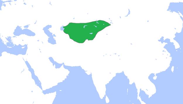
Ten World Regions
1.
Europe,
including the Mediterranean and Aegean islands, that part of the Eurasian
continent to the west of the Caucasus Mountains, but not Asia Minor (now most
of Turkey).
2.
Southwest
Asia- Asia Minor (now Turkey), the Arabian Peninsula, Mesopotamia, Syria,
Persia, the Levant, and Bactria (Afghanistan), but not north of Afghanistan.
3. Africa, including Madagascar.
4. The South Asian subcontinent, including the Indus river valley and Sri Lanka.
5. East Asia, including China, Korea, Japan and Manchuria.
6. Central Asia and Siberia: We
define Central Asia broadly as: the
territory that lies between the eastern edge of the Caspian Sea (longitude E53)
and the old Jade Gate near the city of Dun Huang near longitude E95, and that
is north of latitude N37, (which is the northern edge of the Iranian Plateau,
the northern part of Afghanistan and the mountains along the southern edge of
the Tarim Basin). The northern boundary is the northern edge of the steppes as
they transition into forest and tundra. So the Central Asia region we are
studying includes deserts, mountains and grasslands (steppes) (Hall et al 2009).
7. Southeast Asia, including Indonesia, Malaysia, the Philippines, Cambodia, Burma, Vietnam and Thailand.[1]
8. Oceania, the islands of the Pacific including Australia, New Zealand and Borneo (Papua and Papua New Guinea).
9. North and Central America
10. South America, including Panama and the Caribbean Islands
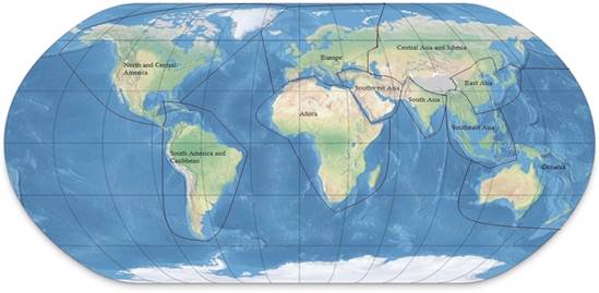
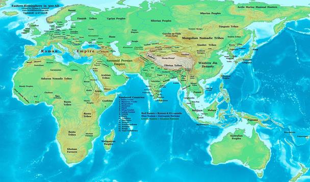
Figure 1: The ten world regions
we are using for comparisons
The
spatio-temporal boundaries of international systems (political-military
networks)
|
Political/Military
Network |
Duration |
Terminus |
|
1. Mesopotamian |
before 3000BC—c. 1500BC |
Coupled with Egyptian to form Central |
|
2. Egyptian |
before 3100 BC- 1500 BC |
Coupled with Mesopotamian to form Central |
|
3. Aegean |
c. 2700 BC—c. 560 BC |
Engulfed by Central |
|
4. Indic |
c. 2300 BC—c. AD 1000 |
Engulfed by Central |
|
5. Irish |
c. AD 450—c. 1050 |
Engulfed by Central |
|
6. Mexican |
before 1100 BC—c. AD 1520 |
Engulfed by Central |
|
7. Peruvian |
before c. 200 BC—c. AD 1530 |
Engulfed by Central |
|
8. Chibchan |
? —c. AD 1530 |
Engulfed by Central |
|
9. Indonesian |
before AD 700—c. 1550 |
Engulfed by Central |
|
10. West African |
c. AD 350—c. 1550 |
Engulfed by Central |
|
11. Mississippian |
c. AD 700—c. 1590 |
Destroyed (Pestilence?) |
|
12. Far Eastern |
before 1500 BC—c. AD 1850 |
Engulfed by Central |
|
13. Japanese |
c. AD 650—c. 1850 |
Engulfed by Central |
|
14. Central |
c. 1500 BC—Present |
? |
Europe and the Central PMN:
city sizes
This figure shows the largest
cities in Europe (blue) and the Central PMN from 1500 BCE to 1800 CE. The
Pearson’s correlation for these is .92. Europe is always part of the Central
PMN in this time period, so the largest city in Europe cannot be larger than
the largest city in the Central PMN. But the reverse can sometimes be true
because the Central PMN contains cities that are not in Europe. From 100 CE to
600 CE the largest cities in Europe are exactly as large as the largest cities
in the Central PMN but for most years before and after that interval the
Central PMN contains larger cities. This comparison is important because the
literature on East/West comparisons is often rather vague as to what exactly in
being compared with what.
Excel
data file of largest settlement sizes:
irows.ucr.edu/cd/appendices/worregs/city_ASA2015_v12.xlsxcity_ASA2015_v12.xlsx Baghdad Problem
Notes on the population size of
medieval Baghdad
|
year |
Population size in thousands |
Areal size in hectares |
|
|
|
799 |
500 |
|
baghdad |
Fletcher |
|
800 |
560 |
7000 |
baghdad |
Lasser, email, p. |
|
800 |
175 |
|
Baghdad |
Morris (2010a, p. 110) |
|
800 |
700 |
|
Baghdad |
Modelski |
|
800 |
700 |
|
Baghdad (arabia) |
Chandler p. 467 |
|
900 |
1500 |
|
baghdad |
fletcher |
|
900 |
900 |
|
Baghdad |
Modelski (2003, p 55, p 219) |
|
900 |
900 |
|
Baghdad (arabia) |
Chandler p. 468 |
|
1000 |
1200 |
|
Baghdad |
Modelski (2003, p 55, p 63) |
|
1000 |
500 |
|
baghdad |
fletcher |
|
1000 |
1500 |
|
Baghdad |
Modelski (2003, p 219) |
|
1000 |
125 |
|
Baghdad (Persia) |
Chandler p. 469 |
|
1100 |
1200 |
|
Baghdad |
Modelski (2003, p 63) |
|
1100 |
No fletcher estimate |
|
baghdad |
fletcher |
|
1100 |
150 |
|
Baghdad (seljuks) |
Chandler p. 470 |
|
1150 |
100 |
|
Baghdad (seljuks) |
Chandler p. 471 |
|
1200 |
100 |
|
bagdhad |
fletcher |
|
1200 |
250 |
|
Baghdad |
Morris (2010a, p. 110) |
|
1200 |
100 |
|
baghdad |
Chandler, p. 472 |
|
1200 |
1000 |
|
baghdad |
Modelski p.63 |
|
1250 |
100 |
|
baghdad |
Chandler, p. 473 |
|
1300 |
40 |
|
baghdad |
fletcher |
|
1300 |
40 |
|
baghdad |
Chandler, p. 474 |
|
1350 |
90 |
|
baghdad |
Chandler (Jelairids) p. 475 |
|
1400 |
90 |
|
baghdad |
fletcher |
Last time, in 2013, we decided to keep morris in 800 and then use Modelski for 900, 100, 1100, and then move back to Morris for 1200. (Modelski has two different estimate for 1000AD in the same book!) If we use both sources, as you notice, the size jumps dramatically from 800 to 900 and shrinks a lot from 1100 to 1200. Very awkward. For this time, should we develop IROWS estimate for the years 900 after? Perhaps, interpolating between 800 and 1200 of Morris? What do you think?
Below is Morris’s justification of his estimate on
Baghdad: (Interestingly he does not pay attention to Modelski)
1200
CE: Baghdad, Cairo, Constantinople, 250,000 (Hourani 1991: 112;
Chandler
1987: 473; Bairoch 1988: 378; Haldon, pers. Comm., October
2005);
2.34 points. There is some disagreement over the populations of these
cities,
but general consensus that all had populations between 200,000 and
300,000.
Some estimates, however (particularly for Baghdad), go much
higher (see under 1000 CE below).
1000
CE: Cordoba, 200,000; 1.87 points. This is my own estimate. Several
estimates
put Cordoba at 400,000-500,000 (e.g., Bairoch 1988: 118; De
Long
and Shleifer 1993: 678; Chandler 1987: 467). Chandler also thinks that
Constantinople’s
population was 300,000 and Baghdad’s 125,000. These
estimates,
however, all seem very high. Haldon (pers. Comm., October 2005)
puts
Constantinople at 150,000, and the settled area of Baghdad (550-860
ha;
Hodges and Whitehouse 1983: 128) seems too small for a population
above
100,000. Cordoba covered roughly twice as large an area, and I
therefore
suggest that its population peaked around 200,000 in the 11th
century.
900 CE:
Cordoba, 175,000; 1.64 points. This is my own estimate. Chandler
(1987:
468) estimates Baghdad at 900,000, Constantinople at 300,000, and
Cordoba
at 200,000. Several other scholars also put the population of
Baghdad
quite high (e.g., Lapidus 2002: 56, at 300,000-500,000), though
nowhere
near as high as Chandler. Lapidus’ estimate would require a
density
of 350-900/ha, and Chandler’s 1,050-1,600. These seem
extraordinarily
high; other large preindustrial cities rarely managed 200/ha (Fletcher 1995).
800 CE:
Baghdad, 175,000; 1.64 points. Again this is my own estimate.
Baghdad
clearly grew very quickly after its foundation in 762, and its
population
may have peaked before the sieges of 812-813 and 865. Chandler
(1987:
468) estimates 700,000 for Baghdad, 250,000 for Constantinople, and
160,000
for Cordoba. Again, these numbers seem very high given the
physical
size of the cities and the generally small populations in the Western
core at
this point, after centuries of plagues. Haldon (pers. Comm., October
2005) sets the population of Constantinople in 750 CE at just 40,000-50,000.
Chandler pp 312-313 notes on Baghdad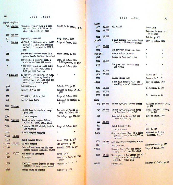
Jacob Lassner, 1970 The Topography of Baghdad_ Detroit:
Wayne State University Press.
So topography is a good way to
estimate the population size of a city because it tells how big the whole
built-up area is and how that changes
over time, and what parts of the city are residential vs other land uses. Lassner’s book is mainly based on a translation
of a description produced by Khatib al-Baghdadi in his Tarikh (history) of
Bagdad, which was written in the 11th century. Khatib died in 1071
CE.
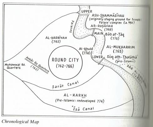
p. 122 in Lassner (1970)
The round city was completed in 766 CE. Total are of the round city= 453 hectares (p. 169)
The total area of greater Baghdad was 7000 hectares (p. 158). Implies that this was in 890 CE, but in email he says it was 800. Lassner’ estimate of the peak population is 560k, but he says this may be low in email. Appendix B is on the development of suburbs. Appendix G. list of caliphs from 750 Ce to 1048 CE.
Modelski
notes on Baghdad p. 184
|
year |
Fletcher |
Lasser |
Morris |
Modelski |
Chandler |
irows |
|
800 |
500 |
560 |
175 |
700 |
700 |
600 |
|
900 |
1500 |
900 |
900 |
1000 |
||
|
1000 |
500 |
1200 |
125 |
500 |
||
|
1100 |
1200 |
150 |
500 |
|||
|
1150 |
100 |
100 |
||||
|
1200 |
100 |
250 |
1000 |
100 |
250 |
|
|
1250 |
100 |
100 |
||||
|
1300 |
40 |
40 |
||||
|
1350 |
90 |
90 |
||||
|
1400 |
90 |
90 |
90 |
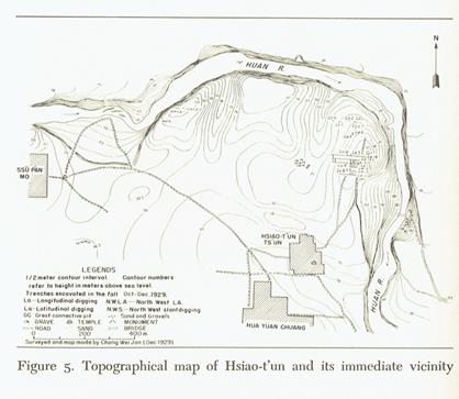
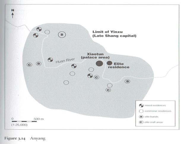
Yin
(ancient late Shang capital) v.
8-17-15
Names: Anyang (modern Chinese city near the site),
Yinxu (waste or ruin of Yin), Xiaotun (Hsiao-tun) small village near the site.
On both sides of the Huan-ho
river. Chi, Li (Li Ji 1977 Anyang.
Seattle, University of Washington Press
Report of excavations from 1928-1937. Academica
Sinica, topo map p. 62.
p. 133 king list Wu Ting -1339-1281. Ti I -1209-1175
Yinxu Xiaomintun Archaeological Team 2008 “The
Shang Building Remains at Xiaomintun in Anyang City” Chinese Archaeology.
Volume 8, Issue 1, Pages 8–15, (January)
Wiki says area size of site is 30 sq
kilometers.
Chandler has no estimate for -1300. His estimate for Anyang (note on p. 94) in -1200
is 30,000 (p. 460) based on the evidence that the army was 5,000 and he
multiplies time 6.
|
year |
Chandler |
Modelski |
Yoffee |
Morris |
Irows* |
|
-1300 |
|
120 |
|
|
30 |
|
-1200 |
30 |
120 |
120 |
50 |
100 |
|
-1100 |
|
|
120 |
50 |
100 |
* Because
Morris does not include the suburbs (see below) we may assume that his estimate
is somewhat low for the greater urban area.
Yoffee’s high estimate is based on the total land area, but Morris is
probably right that the settlements were spread out within much of this area.
Modelski’ estimates for Yin are in a table on
p. 35. Notes for Yin are on p. 140.

Yoffee, Norman 2005 Myths of the Archaic State. Cambridge: Cambridge University Press.
P. 43 Area and population size estimates of the
earlier cities mentioned in the text
Anyang/Yinxu (1250-1046 BC) 19 km squared,
100,000 Liu pc; Yates 1997
Map p.71
Yates, R. 1997 “The city-state in ancient China
PP. 71-90 in D. Nichols and T. Charlton (eds.) The Archaeology of City-States
Washington, DC: Smithsonian Institution Press.
Ian Morris, Social Development, p. 118
1200
BCE: Anyang, 50,000; 0.47 points
1100
BCE: Anyang, 50,000; 0.47 points
p.
126
1100
BCE: Anyang, 50,000 (my estimate); 0.47 points. Anyang, the final
Shang
dynasty capital, has been extensively excavated since 1928, although the walled
city at Huanbei was only
located in 1997. Huanbei’s walls enclose 470 ha, and a population of
20,000-25,000 seems plausible, but other remains at Anyang sprawl across some
30 km2 (Thorp 2006: 125-71; Chang 1980; Liu and Chen 2010). As in the
early 1st millennium BCE (see under 600 BCE), it becomes hard to define where
the boundaries of a “city” are in such a dispersed settlement system. My
suggestion of 50,000 is therefore somewhat arbitrary; defining the city very
narrowly as just the walled area could cut this estimate by 50 percent, while
defining it very loosely to include the suburbs could
perhaps raise the total to 100,000 or more. Fifty thousand would make Anyang as
large as Memphis in 1100 BCE; 100,000 would make it the biggest city in the
world in the 13th through 11th centuries BCE. I offer the figure of 50,000 as a
sensible middle ground between the very narrow and very loose definitions of
the city.
Anyang
was founded around 1300
BCE and by 1200 had clearly become a major settlement (however defined).
Given the uncertainties of the estimate for 1100 BCE, there seems little point
in compounding the
difficulties
by offering a different estimate for 1200, so I simply propose
50,000
for both dates.
1200
BCE: Anyang, 50,000 (my estimate); 0.47 points. See under 1100 BCE. The walled
settlement at Sanxingdui may cover as much as 350 ha (Thorp 2006: 64), and
might have been a rival to Anyang for population, but it remains poorly known.
Nothing
in Fletcher.
Settlement Size Sources
Bibliography
Adams, Robert McCormick 1981 The Heartland of Cities: Surveys of Ancient Settlement and Land Use on
the Central
Floodplain of the Euphrates. Chicago: University of Chicago Press
ARVE Population World Atlas http://arve.unil.ch/popmap
Bairoch,
Paul 1988 Cities and economic
development : from the dawn of history to the present Chicago:
University of Chicago Press
Bairoch, Paul, Jean Batou and Pierre Chevre
1988 The Population of European Cities,
800 to 1850: Data Bank and Short Summary of Results. Geneva: Librairie
Droz, 11 rue Massot
__________
1988 [The population of European cities. Data bank and short
summary of results: 800-1850] La population des villes europeennes. Banque de
donnees et analyse sommaire des resultats: 800-1850. Geneva, Switzerland, Librairie
Droz, http://www.popline.org/node/366534
Beaverstock, J.V., P.J. Taylor and R.G. Smith. 1999. “A roster of world cities.” Cities 16: 445-458.
Bosworth, Andrew 2000 "The evolution of the world city system,
3000 BCE to AD 2000"
Pp. 273-284 in Robert A. Denemark
et al eds. ) World System History.
London:
Routledge.
Braudel,
Fernand 1972 The Mediterranean and the
Mediterranean World in the Age of Philip II. New York:
Harper and Row, 2 vol.
Brown, Barton M. 1987 “Population estimation from floor
area,” Behavior Science Research
21:1-49.
Chapman, Anne C. 1957 “Port of trade enclaves in Aztec and Maya civilizations” Pp. 114-153 in
Karl
Polanyi, Conrad M. Arensberg and Harry W. Pearson, Trade and Markets in the Early
Empires. Chicago: Henry Regnery.
Chandler, Tertius and Gerald Fox 1974 Three Thousand Years of Urban Growth. New York: Academic Press
Chandler, Tertius 1987 Four Thousand Years of Urban Growth: An Historical Census. Lewiston, N.Y.: Edwin
Mellon Press
Chase-Dunn, Christopher 1985 "The system of world
cities: A.D. 800-1975." Pp. 269-292 in
Michael Timberlake (ed.) Urbanization in the World-Economy, New
York:Academic
Press.
Chase-Dunn, C. and E. Susan Manning 2002 “City systems and
world-systems: four
millennia of city growth an
decline.” Cross-Cultural Research 36,4:379-398.
Chase-Dunn, C. and Andrew K. Jorgenson 2003 “Regions and Interaction Networks: an institutional
materialist perspective,” International Journal of Comparative Sociology 44, 1:433-450.
Chase-Dunn C, and Alice Willard 1994 "Cities in the Central Political-Military Network Since CE 1200"
Comparative Civilizations Review, 30:104-32 (Spring).
Ciolek, Matthew n.d. OWTRAD: Old World Trade
Routes Project. http://www.ciolek.com/owtrad.html
Coquery-Vidrovitch,
Catherine 2008 The History of African
Cities South of the Sahara. Princeton, NJ: Markus
Wiener.
Davis,
Kingsley 1969 World
Urbanization 1950-1970, Volume 1. Institute of International Studies,
University
of California, Berkeley.
De
Vries, Jan 1984 European Urbanization,
1500-1800 Cambridge, MA: Harvard University Press.
Fletcher, Roland 1995 The Limits of Settlement Growth. Cambridge: Cambridge University Press.
______ n.d. City and Polity Data Files, Personal communication
Hardoy,
Jorge and Maria Elena Langdon
1978 “Analisis estadistico preliminar de
la Urbanizacion de
America Latina entre 1850 y 1930,” Revista
Paraguaya de Sociologia 42/43: 115-173 (May-
December).
Hansen, M.H. 2000. "Introduction: The concepts of
city-state and city-state culture," Pp. 11-34 in Mogens Herman Hansen (ed.),
A comparative study of thirty city-state
cultures. Copenhagen: The Royal Danish
Academy of Sciences and Letters
Hassan,
Fekri A. 1981 Demographic Archaeology. New York: Academic Press.
Inoue, Hiroko,
Alexis Álvarez, Eugene N. Anderson, Andrew Owen, Rebecca Álvarez,
Kirk Lawrence and
Christopher Chase-Dunn 2015 “Urban scale shifts since the Bronze Age: upsweeps, collapses and
semiperipheral development” Social Science History Volume 39 number 2, Summer
Lassner, Jacob 1970 The Topography of Baghdad_ Detroit:
Wayne State University Press.
Lyman, Bradford 1989
Urban primacy: A cross-national study.
Unpublished Dissertation: University of
Maryland http://www.irows.ucr.edu/cd/courses/10/readme.html
Modelski, George 2003 World Cities: –3000 to 2000. Washington, DC: Faros 2000
Morse, Richard M. (ed.) with Michael Conniff and John Wibel 1971 The Urban Development of Latin America 1750-1920. Stanford University: Center for Latin American Studies.
Morris, Ian 2013 The Measure of Civilization. Princeton, NJ: Princeton University Press.
Nichols, Deborah L and Thomas H. Charlton (eds.) 1997 The Archaeology of City-States. Washington,
DC: Smithsonian Institution Press.
OpenHistory http://openhistory.net/)
Pasciuti , Daniel 2002” A
measurement error model for Estimating the Population Sizes of Preindustrial
Cities” https://irows.ucr.edu/research/citemp/estcit/modpop/modcitpop.htm
Pasciuti, Daniel and Christopher Chase-Dunn 2002 “Estimating the Population Sizes of
Cities” https://irows.ucr.edu/research/citemp/estcit/estcit.htm
Petermann’s Geographische Mitteilungen 1865 ff. Gotha, 1857
Rozman, Gilbert 1973 Urban Networks in Ching China and Tokogawa Japan. Princeton, NJ: Princeton University
Press.
Russell, Josiah Cox 1972 Medieval Regions and their Cities. Bloomington, IN: Indiana University Press.
SESHAT: The Global History Data Bank. The Evolution
Institute http://evolution-institute.org/seshat
Smith, Charlotte Ann 2002 “Concordant change and core-periphery dynamics: a synthesis of highland
Mesoamerican archaeological data” University of Georgia, PhD dissertation.
Smith, Michael E. 2005 “City size
in late postclassic Mesoamerica” Journal
of Urban History 31, 4: 403-434.
Smith, Michael E. Gary M. Feinman, Robert D. Drennan, Timothy Earle and Ian Morris 2012
“Archaeology as a social science” PNAS, 109. 20: 7617–7621 (May 15)
Skinner, G. William (ed.) 1977. The City in Late Imperial China Stanford: Stanford University
Press.
Turchin, Peter and Sergey Nefadov 2009 Secular Cycles Princeton, NJ: Princeton University Press.
United Nations 2011a Data on Cities and Urban Agglomerations
http://esa.un.org/unpd/wup/CD-ROM/Urban-Agglomerations.htm
United Nations 2011b World Urbanization Prospects: The 2011 Revision:
Methodology http://esa.un.org/unpd/wup/pdf/WUP2011_Methodology.pdf
Weber,
Adna Ferrin 1963 [1899] The Growth of
Cities in the Nineteenth Century: A Study in Statistics. Ithaca, NY:
Cornell University Press.
White,
D. R., Natasa Kejzar and Laurent Tambayong 2006 “Oscillatory dynamics of
city-size distributions
in world historical systems”. Pp.
190-225 in G. Modelski, T. Devezas and W. Thompson, (eds.)
Globalization
as Evolutionary Process: Modeling, Simulating, and Forecasting Global Change..
London:
Routledge.
Wilkinson, David 1987 "Central Civilization." Comparative Civilizations Review 17:31-59.
______________1991 "Core, peripheries and civilizations." Pp. 113-166 in Christopher
Chase-Dunn and Thomas D. Hall (eds.) Core/Periphery Relations in Precapitalist Worlds,
Boulder, CO.: Westview.
_______________1992a "Decline phases in civilizations, regions and oikumenes." A paper presented at the
annual meetings of the International Studies Association, Atlanta, GA. April 1-4.
______________ 1992b "Cities, civilizations and oikumenes:I." Comparative Civilizations Review 27:51-87
(Fall).
_______________ 1993 “Cities, civilizations and oikumenes:II” Comparative Civilizations Review 28: 41-72.
_______________2004 The
Power Configuration Sequence of the Central World System, 1500-700 BC Journal
of World-Systems Research Vol. 10, 3.
Wilkinson’s Maps: https://irows.ucr.edu/research/citemp/asa01/wilkinson.htm
Yoffee,
Norman 2005 Myths of the Archaic State.
Cambridge: Cambridge University Press. P. 43 Area and population size estimates
of the earlier cities mentioned in the text
Excel
data files of largest city sizes:
irows.ucr.edu/cd/appendices/worregs/largestcitiesinworldregions.xlsx
Missing
cases (redo the empires)
Count of largest city estimates across ten world regions (ignore empire count – see below)
Count of largest polity estimates across ten world regions
Largest
polities since -1500, v.
10-24-15
Taagepera
|
-1500 |
|
0.65 |
West
Asia/Africa |
18th Dynasty |
Thebes |
Taagepera 1978 b, p182 |
dynasty
name is changed from Taagepera |
|
|
|
|
|
-1500 |
|
0.25 |
West
Asia/Africa |
Mitanni |
Washukanni |
Taagepera, 1978 b, p191 |
|
|
|
|
|
|
-1500 |
|
0.15 |
West
Asia/Africa |
Hittites
(Interpolated) |
|
|
|
|
|
|
|
|
-1500 |
|
0.10 |
West
Asia/Africa |
Elam
(Interpolated) |
|
|
|
|
|
|
|
|
-1500 |
|
0.10 |
West
Asia/Africa |
Babylon
(Interpolated) |
|
|
|
|
|
|
|
|
-1500 |
|
0.03 |
West
Asia/Africa |
Assyria
(Interpolated) |
|
|
|
|
|
|
|
Re
Babylon Wikipedia says:” Following the sack of Babylon by the Hittite Empire, an Indo-European speaking nation in Asia Minor,
the Kassites, a people speaking a Language Isolate and hailing from the Zagros Mountains of north western Ancient Iran invaded and took over Babylon, ushering in a
dynasty that was to last for 435 years until 1160 BC. The city was
renamed Karanduniash during this
period.”
And also
“Hammurabi's empire quickly dissolved after his death, the Assyrians defeated
and drove out the Babylonians and Amorites, the far south of Mesopotamia broke
away, forming the Sealand Dynasty,
and the Elamites appropriated territory in eastern Mesopotamia.”
For
-1500 geacron has
And they
have Shang as large as Egypt and Mycenaen
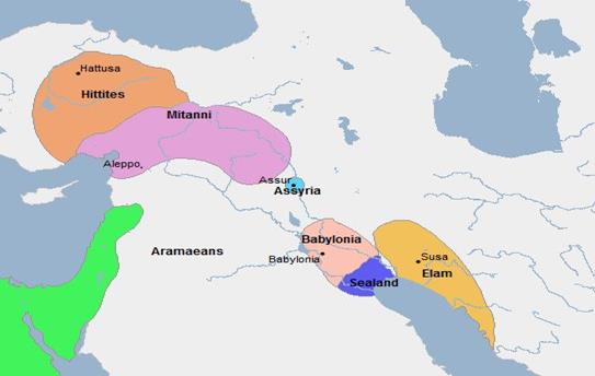
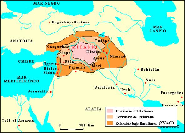
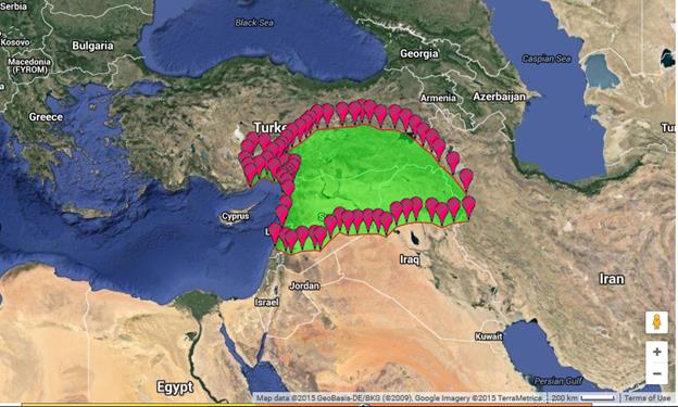
Mitanni
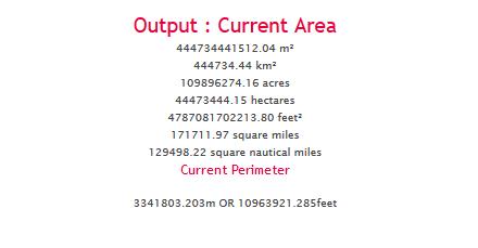
Google: http://www.daftlogic.com/projects-google-maps-area-calculator-tool.htm
Conversion
to square mega meters:
0.44473444
Sq.MM

Shang,
1556 BC to 1046 BC;
Capital= Ao
Geacron has it as large as eqypt (.65).
Mycenae
By 1200
BC, the power of Mycenae was declining; finally, during the 12th century BC,
Mycenaean dominance collapsed entirely. (added city 30 k to city data set).
-1400
|
-1400 |
0.90 |
Africa |
Central
System |
18th
Dynasty |
Thebes |
Taagepera 1978 b, p182 |
|
dynasty
name is changed from Taagepera |
|
|
|
-1400 |
0.10 |
Southwest
Asia |
Central
System |
Babylon |
Babylon |
Taagepera, 1978, p186 |
|
|
|
|
|
-1400 |
0.10 |
Southwest
Asia |
Central
System |
Elam |
Susa |
Taagepera 1978 b, p186 |
|
|
|
|
|
-1400 |
.35 |
Southwest Asia |
Central System |
Mitanni |
Washukanni |
|
|
|
|
|
wikipedia has this and says “Map of the Near East ca. 1400 BC showing the Kingdom of Mitanni at its greatest extent” https://en.wikipedia.org/wiki/Mitanni
Liverani, Mario 2013 The Ancient Near East.
New York: Routledge. Check .35 size estimate
-1300
|
-1300 |
1 |
1.00 |
|
Africa |
Central
System |
18th Dynasty |
|
Thebes |
Taagepera 1978 b, p182; Turchin, Adams and Hall., Table 1 |
dynasty
name is changed from Taagepera |
|
-1300 |
|
|
|
Central
Asia and Siberia |
|
|
|
|
|
|
|
-1300 |
2 |
0.70 |
|
East
Asia |
East
Asian System |
Shang |
|
Anyang |
Taagepera 1978a p.116 |
|
|
-1300 |
4 |
0.15 |
|
Europe |
Central
System |
Mycenaen |
|
Mycenae |
Geacron, Wikipedia |
|
|
-1300 |
|
|
|
North
and Central America |
|
|
|
|
|
|
|
-1300 |
|
|
|
Oceania
|
|
|
|
|
|
|
|
-1300 |
|
|
|
South
America and Caribbean |
|
|
|
|
|
|
|
-1300 |
|
|
|
South
Asia |
Indonesian
Sysem |
Normadic Aryans |
|
|
|
|
|
-1300 |
|
|
|
Southeast
Asia |
|
|
|
|
|
|
|
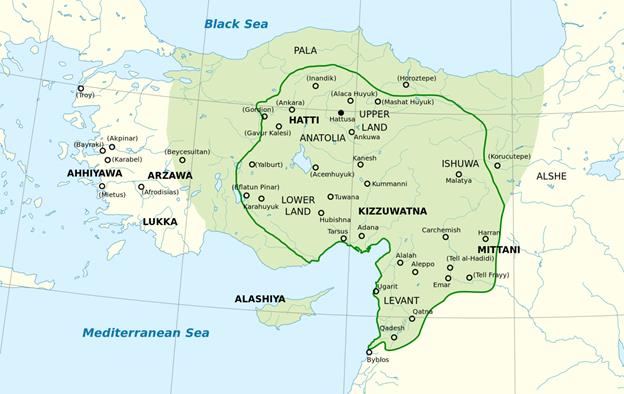
-1300 |
3 |
0.40 |
|
Southwest
Asia |
Central
System |
Hittites |
|
Hattusa |
Taagepera 1978 b, p188 |
|
|
-1300 |
5 |
0.14 |
|
Southwest
Asia |
Central
System |
Elam |
interpolation |
|
|
|
|
-1300 |
6 |
0.11 |
|
Southwest
Asia |
Central
System |
Assyria |
interpolation |
Assur |
|
|
Hittites
-1200
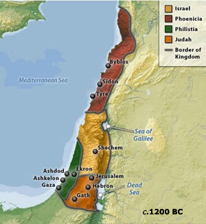
Israel
-1100
Hittites
disintegrated in -1180. Although
the Hittite kingdom disappeared from Anatolia at this point, there emerged a
number of so-called Neo-Hittite kingdoms in Anatolia and northern
Syria. They were the successors of the Hittite Kingdom. The most notable Syrian
Neo-Hittite kingdoms were those at Carchemish
and Milid (near the later Melitene). Others were called Syro-Hittite
kingdoms, and appeared to be a fusion of Indo-European Hittites and Semitic Arameans.
All of these kingdoms gradually fell under the control of the Neo Assyrian Empire (911–608 BC), which went on to
conquer much of the Middle East, Asia Minor, Arabia, the Caucasus, east
Mediterranean and Northwest Africa. The last of them, Carchemish and Milid, were made vassals of Assyria under Shalmaneser III
(858–823 BC), and fully incorporated into Assyria during the reign of Sargon II
(722–705 BC).
The Carcamesh polity is on the Geacron
map for -1000 but is too small to b in the top 6. Ditto -1100.
Egypt
The Pharaohs
of the 20th dynasty ruled for approximately 120 years: from ca 1187 to 1064 BC.
Phrygia capital= Gordium
Phrygian
power reached its peak in the late 8th century BC under another, historical
king Midas,
who dominated most of western and central Anatolia and rivaled Assyria
and Urartu
for power in eastern Anatolia. This later Midas was, however, also the last
independent king of Phrygia before its capital Gordium was sacked by Cimmerians
around 695 BC. Phrygia then became subject to Lydia,
and then successively to Persia, Alexander
and his Hellenistic successors
Elam? Elamite Empire. Not on Geacron in
-1100 but it should be getting smaller until
-770
Under the Shutrukids
(c. 1210–1100), the Elamite empire reached the height of its power. Shutruk-Nakhkhunte and his three sons, Kutir-Nakhkhunte II, Shilhak-In-Shushinak, and Khutelutush-In-Shushinak were capable of frequent military campaigns into
Kassite Babylonia (which was also being ravaged by the empire of Assyria during this period), and at the
same time were exhibiting vigorous construction activity—building and restoring
luxurious temples in Susa and across their Empire. Shutruk-Nakhkhunte
raided Babylonia, carrying home to Susa trophies like the statues of Marduk and Manishtushu, the Manishtushu Obelisk, the Stele of Hammurabi and the stele
of Naram-Sin. In 1158 BC, after much of
Babylonia had been annexed by Ashur-Dan I of Assyria and Shutruk-Nakhkhunte, the Elamites defeated the Kassites permanently, killing the Kassite king of Babylon, Zababa-shuma-iddin, and replacing him with his
eldest son, Kutir-Nakhkhunte, who held it no more
than three years before being ejected by the native Akkadian speaking Babylonians. The Elamites then briefly came
into conflict with Assyria, managing to take the Assyrian
city of Arrapha before being ultimately defeated
and having a treaty forced upon them by Ashur-Dan I.
Kutir-Nakhkhunte's son Khutelutush-In-Shushinak was probably of an incestuous relation of Kutir-Nakhkhunte's with his own daughter, Nakhkhunte-utu.[citation
needed] He was defeated by Nebuchadnezzar I of Babylon, who sacked Susa and
returned the statue of Marduk, but who was then
himself defeated by the Assyrians. He fled to Anshan, but later returned to
Susa, and his brother Shilhana-Hamru-Lagamar may have succeeded him as last
king of the Shutrukid dynasty. Following Khutelutush-In-Shushinak, the
power of the Elamite empire began to wane seriously, for with this ruler, Elam
disappears into obscurity for more than three centuries.
Neo-Elamite
Period Neo-Elamite
I (c. 1100–770)
Very little is known of this
period. Anshan was still at least partially Elamite. There appear to have been unsucessful alliances of Elamites, Babylonians and
Chaldeans against the powerful Neo
Assyrian Empire;
the Babylonian king Mar-biti-apla-ushur (984–979) was of Elamite origin,
and Elamites are recorded to have fought unsuccessfully with the Babylonian
king Marduk-balassu-iqbi against the Assyrian forces under Shamshi-
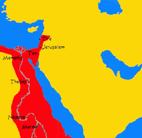
-1000
Egypt 21st
dynasty -1077—943, Tanis
geacron has Tanis as separate from Egypt
in -1000 but it was not.
The kings at Tanis saw themselves as the legitimate successors on the throne of Upper and Lower Egypt. They used traditional titles and displayed their royalty in building work, although that was insignificant when compared to activity at the height of the New Kingdom.[1]
Tanis was founded in the late Twentieth Dynasty,[citation needed] and became the northern capital of Egypt during the following Twenty-first Dynasty. It was the home city of Smendes, founder of the 21st dynasty. During the Twenty-second Dynasty Tanis remained as Egypt's political capital (though there were sometimes rival dynasties located elsewhere in Upper Egypt).
Israel: Geacron
has Israel pretty big in -1000, but this is too early.
Kush
1070 BC–AD 350
With the
disintegration of the New Kingdom around 1070 BC, Kush became an
independent kingdom centered at Napata
in modern central Sudan.[7]
-900
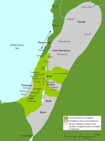
Israel
and Judah
The Kingdom of
Israel
emerged as an important local power by the 9th century BCE before falling to
the Neo-Assyrian Empire in 722 BCE. Israel's
southern neighbor, the Kingdom of Judah, emerged in the 8th century[1]
and enjoyed a period of prosperity as a client-state of first Assyria and then Babylon
before a revolt against the Neo-Babylonian Empire led to its destruction in
586 BCE.
Geacron has Israel pretty big in -1000
Phrygia
Phrygian
power reached its peak in the late 8th century BC under another, historical
king Midas,
who dominated most of western and central Anatolia and rivaled Assyria
and Urartu
for power in eastern Anatolia. This later Midas was, however, also the last
independent king of Phrygia before its capital Gordium was sacked by Cimmerians
around 695 BC. Phrygia then became subject to Lydia,
and then successively to Persia, Alexander
and his Hellenistic successors,
-800
Urartu
Got big
as Assyria
23rd
dynasty The Twenty-third
Dynasty of ancient Egypt was a separate regime of Meshwesh Berber
Libyan
kings,
who ruled ancient Egypt. This dynasty is often
considered part of the Third
Intermediate Period.
|
Usermaatre-Meryamun |
804 – 798 BC |
|
Succeeded
Pedubast I at Thebes and ruled Upper Egypt for 6
years. |
There is
much debate surrounding this dynasty, which may have been situated at Herakleopolis Magna,
Hermopolis Magna,
and Thebes but monuments from their reign
show that they controlled Upper Egypt in parallel with the Twenty-second
dynasty of Egypt
shortly before the death of Osorkon II.
-730 
-700
Phrygia
got bigger.
Egypt
The Twenty-fifth
Dynasty of Egypt, known as the Nubian Dynasty or the Kushite Empire, was the last dynasty of the Third
Intermediate Period
of Ancient Egypt.
Kush
|
Kush
in -700 |
Capital
moved to Napata |
780 BC |
|
Urartu: |
Tiglath Pileser III of Assyria conquered Urartu in the first year of his
reign (745 BC) |
|
Rusa's son Argishti II (714 – 685 BC) restored Urartu's position against the Cimmerians, however it was no longer a threat to Assyria and peace was made with the new king of Assyria Sennacherib in 705 BC. This in turn helped Urartu enter a long period of development and prosperity, which continued through the reign of Argishti's son Rusa II (685–645 BC).
After Rusa II, however, the Urartu grew weaker under constant attacks from Cimmerian and Scythian invaders. As a result it became dependent on Assyria, as evidenced by Rusa II's son Sardur III (645–635 BC) referring to the Assyrian king Ashurbanipal as his "father." [28][29]
-600
Medes
and Persians to capture Nineveh in 612 BCE,
which resulted in the eventual collapse of the Neo-Assyrian Empire by 605 BC.
In
612 BC, the Median king Cyaxares the Great
together with Nabopolassar of Babylon
and the Scythians conquered Assyria after it had
been badly weakened by civil war.
Medes
After
the fall of the Assyrian Empire, between 616 BCE and 605 BCE, a unified Median
state was formed, which, together with Babylonia,
Lydia,
and Egypt, became one of the four major
powers of the ancient Near East. The Median kingdom was
conquered in 550 BCE by Cyrus the Great
585 peak
size.
Egypt 655
emancipation from Assyria
The Twenty-sixth
Dynasty of Egypt was the last native dynasty to rule Egypt
before the Persian
conquest
in 525 BC
Jin Duke Ding of Jin (simplified
Chinese: 晋定公; traditional
Chinese: 晉定公; pinyin:
Jìn Dìng Gōng,
died 475 BC) was from 511 to 475 BC the ruler of the state of Jin, Despite the civil war, Jin was still one of the most powerful states of China.
-500
Kush
|
Capital
moved to Meroe |
591 BC |
|
|
|
-400
Egypt
28th dynasty The
Twenty-Eighth Dynasty of Egypt had one ruler, Amyrtaeus, who was a descendant of the Saite kings of the Twenty-Sixth
Dynasty,
and led a successful revolt against the Persians
on the death of Darius II. No monuments of his reign have
been found, and little is known of his reign.
|
404 - 398 BC |
Artaxerxes II continued to be recognized as king at Elephantine as late as 401 BC, but Aramaic papyri from the site refer to Regnal Year 5 of Amyrtaeus in September 400 BC. The Elephantine papyri also demonstrate that between 404 and 400 BC (or even 398) Upper Egypt remained under Persian control, while the forces of Amyrtaeus dominated the Delta.
Amyrtaeus was defeated in open battle by his successor, Nepherites I of Mendes, and executed at Memphis, an event which the Aramaic papyrus Brooklyn 13 implies occurred in October 399 BC.
Maghada According to tradition, the Shishunaga dynasty expanded the Magadha Empire in 413 BC, whose capital was Rajagriha, later Pataliputra, near the present day Patna in India. This dynasty was succeeded by the Nanda dynasty. Shishunaga (also called King Sisunaka) was the founder of a dynasty of 10 kings, collectively called the Shishunaga dynasty. He expanded the Magadha empire (in 413 BC). This empire, with its original capital in Rajgriha, later shifted to Pataliputra (both currently in the Indian state of Bihar). The Shishunaga dynasty in its time was one of the largest empires of the Indian subcontinent.
-300
egypt 
Thrace
The Odrysian Kingdom (/oʊˈdrɪʒən/; Ancient Greek: Βασίλειον Ὀδρυσῶν) was a state
union of Thracian
tribes that endured between the 5th and 3rd centuries BC. It consisted mainly
of present-day Bulgaria, spreading to parts of Northern Dobruja, parts of Northern Greece
and parts of modern-day European Turkey. King Seuthes III
later moved the capital to Seuthopolis.

Nanda (345–321 BCE)
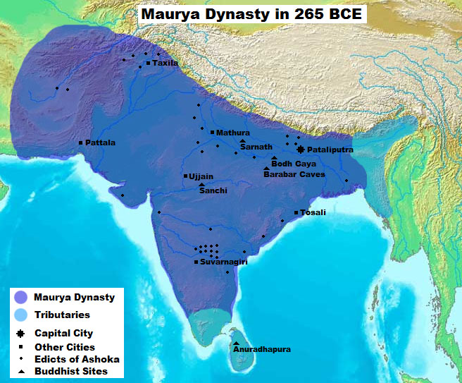
Maurya The Maurya
Empire was a geographically extensive Iron Age
historical power in ancient India, ruled by the Maurya
dynasty from 322 – 185 BCE
-200
Maurya
|
|
202 BC |
195 BC |
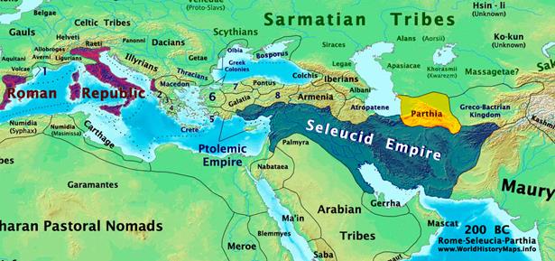
Parthia
The Parthian
Empire (/ˈpɑrθiən/; 247 BC – 224 AD),
also known as the Arsacid Empire /ˈ
-100
Sunga
The Shunga Empire
is a Magadha
dynasty that controlled North-central and Eastern India as well as parts of the
northwest (now Pakistan) from around 185 to 73 BCE. It
was established after the fall of the Indian Maurya Empire.
The capital of the Sungas was Pataliputra. Later kings such as Bhagabhadra also held court at Vidisha, modern Besnagar in Eastern Malwa.[22]
The Sunga Empire is noted for its numerous wars with both foreign and
indigenous powers.
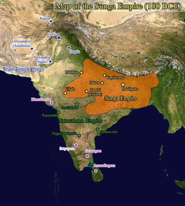
Satavana
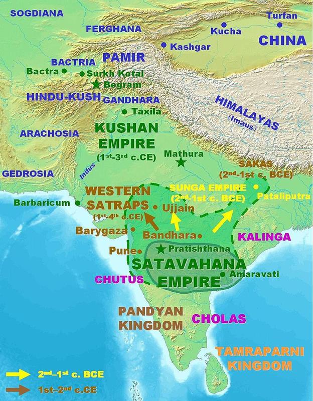
Indo-greeks 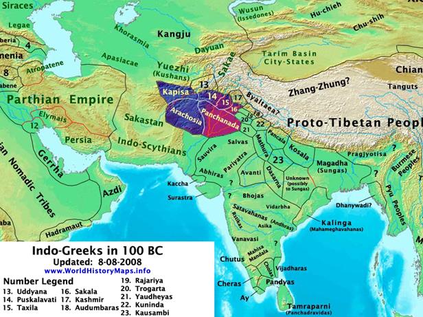
1
CE
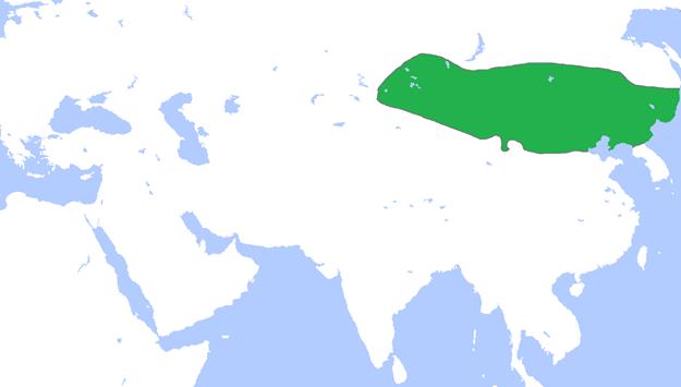
Xiongnu
Meroe
In 23 BC the Roman governor of Egypt, Publius Petronius, to end the Meroitic raids, invaded Nubia in response to a Nubian attack on southern Egypt, pillaging the north of the region and sacking Napata (22 BC) before returning home. In retaliation, the Nubians crossed the lower border of Egypt and looted many statues (among other things) from the Egyptian towns near the first cataract of the Nile at Aswan. Roman forces later reclaimed many of the statues intact, and others were returned following the peace treaty signed in 22 BCE between Rome and Meroe. One looted head though, from a statue of the emperor Augustus, was buried under the steps of a temple. It is now kept in the British Museum.[8]
The next recorded contact between Rome and Meroe was in the autumn of AD 61. The Emperor Nero sent a party of Praetorian soldiers under the command of a tribune and two centurions into this country, who reached the city of Meroe where they were given an escort, then proceeded up the White Nile until they encountered the swamps of the Sudd. This marked the limit of Roman penetration into Africa.[9]
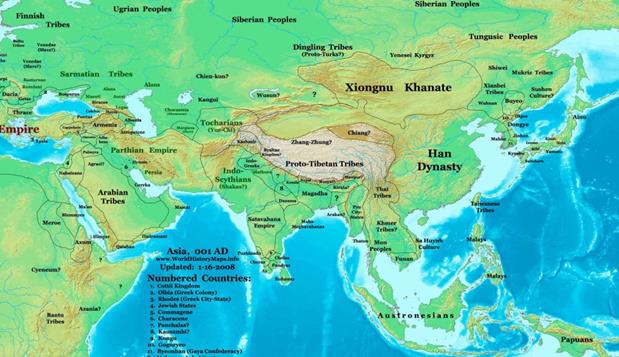
Parthia
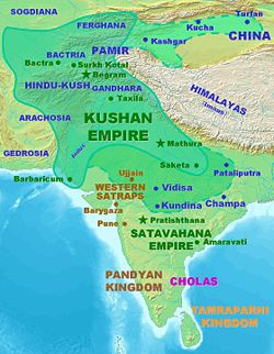
100CE
Kushan
an empire in South Asia originally formed in the early
1st century CE under Kujula Kadphises in the territories of ancient Bactria
around the Oxus River (Amu Darya), and later based near Kabul,
Afghanistan.[
The Kushans spread from the Kabul River Valley to defeat other Central Asian tribes that had previously conquered parts of the
northern central Iranian Plateau once ruled by the Parthians,
and reached their peak under the Buddhist
emperor Kanishka (127–151), whose realm stretched
from Turfan
in the Tarim Basin
to Pataliputra on the Gangetic Plain."[3]
Xiongnu, geacron has
big xiongnu, but they r wrong
As the eldest son of the preceding chanyu, Bi had a legitimate claim to the succession. In 48, two years after Huduershi's son Punu ascended the throne, eight Xiongnu tribes in Bi's powerbase in the south, with a military force totalling 40,000 to 50,000 men, acclaimed Bi as their own chanyu. Throughout the Eastern Han period, these two groups were called the southern Xiongnu and the northern Xiongnu, respectively.
Hard pressed by the northern Xiongnu and plagued by natural calamities, Bi brought the southern Xiongnu into tributary relations with Han China in 50. The tributary system was considerably tightened to keep the southern Xiongnu under Han supervision. The chanyu was ordered to establish his court in the Meiji district of Xihe commandery. The southern Xiongnu were resettled in eight frontier commanderies. At the same time, large numbers of Chinese were forced to migrate to these commanderies, where mixed settlements began to appear. The northern Xiongnu were dispersed by the Xianbei in 85 and again in 89 by the Chinese during the Battle of Ikh Bayan, in which the last Northern Chanyu was defeated and fled over to the north west with his subjects.
Ban Chao was created the Marquess
of Dingyuan (定遠侯, i.e., "the Marquess who stabilized faraway places") for his
services to the Han Empire and returned to the capital Loyang
at the age of 70 years old and died there in the year 102. Following his death,
the power of the Xiongnu in the Western Regions
increased again, and the emperors of subsequent dynasties were never again able
to reach so far to the west.
200
ce
Xiongnu, funan
a
foreigner named "Huntian" [pinyin: Hùntián] established the Kingdom of Funan
around the 1st century CE in the Mekong Delta of southern Vietnam.
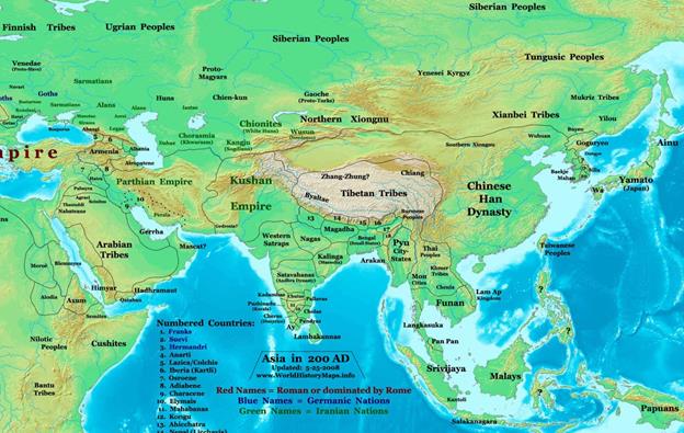
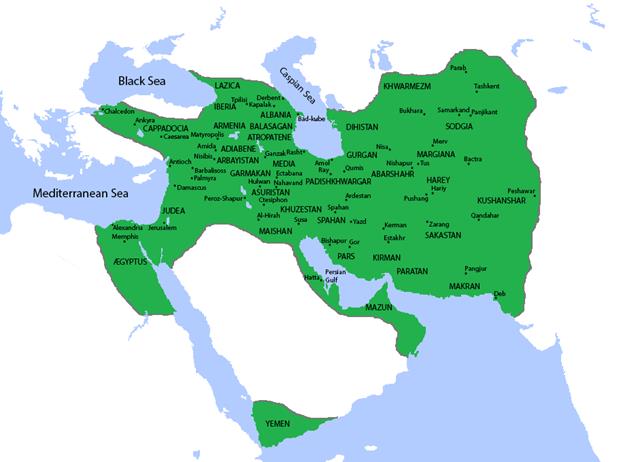
Sassanian
empire
Aksum
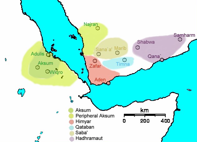
230
ad
300
ce
Kushan After the death of Vasudeva I in 225, the Kushan empire split into western and eastern halves. The Western Kushans (in Afghanistan) were soon subjugated by the Persian Sassanid Empire and lost Bactria and other territories. In 248 they were defeated again by the Persians, who deposed the Western dynasty and replaced them with Persian vassals known as the Kushanshas (or Indo-Sassanids).
The Eastern Kushan kingdom was based in the Punjab. Around 270 their territories on the Gangetic plain became independent under local dynasties such as the Yaudheyas. Then in the mid-4th century they were subjugated by the Gupta Empire under Samudragupta.
In 360 a Kushan vassal named Kidara overthrew the old Kushan dynasty and established the Kidarite Kingdom
Funan An
Eastern Wu embassy was sent from China to Funan in
228.[36]
A brief conflict is recorded to have happened in the 270s, when Funan and its neighbour, Linyi,
joined forces to attack the area of Tongking (Vietnamese: Đông Kinh, "eastern
capital"), located in what is now modern Northern Vietnam (which was a Chinese colony at the time).
Jin dynasty (265–420)
Vakataka 250-500The Vākāṭaka
Empire (Marathi:
वाकाटक) was a royal Indian
dynasty
that originated from the Deccan in the mid-third century CE.
Their state is believed to have extended from the southern edges of Malwa and Gujarat
in the north to the Tungabhadra River in the south as well as from the Arabian Sea in the western to the edges of Chhattisgarh in the east. They were the most important
successors of the Satavahanas in the Deccan
and contemporaneous with the Guptas in northern India. Capital= Vatsagulma
400
ce
Eastern
jin The
remnants of the Jin court fled to the east and reestablished
the government at Jiankang, near modern-day Nanjing,
under a member of the royal family named the Prince of Langye.
The prince was proclaimed the Emperor Yuan of the Eastern Jin dynasty (東晉, 317–420) when news of the fall
of Chang'an in 316 reached the south.
Gupta
320-550
Sassanian the last Iranian empire before the rise of Islam,
ruled by the Sasanian
dynasty
from 224 CE to 651 CE
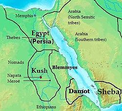
Aksum 100-940 Around 520, the King Kaleb sent an expedition to Yemen against the Jewish Himyarite King Dhu Nuwas, who was persecuting the Christian/Aksumite community in his kingdom. Dhu Nuwas was deposed and killed and Kaleb appointed a Christian Himyarite, Sumuafa Ashawa, as his viceroy. However, around 525 this viceroy was deposed by the Aksumite general Abreha with support of Ethiopians who had settled in Yemen, and withheld tribute to Kaleb. When Kaleb sent another expedition against Abreha this force defected, killing their commander, and joining Abreha. Another expedition sent against them was defeated, leaving Yemen under Abreha's rule, where he continued to promote the Christian faith until his death, not long after which Yemen was conquered by the Persians. According to Munro-Hay these wars may have been Aksum's swan-song as a great power, with an overall weakening of Aksumite authority and over-expenditure in money and manpower. According to Ethiopian traditions, Kaleb eventually abdicated and retired to a monastery. It is also possible that Ethiopia was affected by the Plague of Justinian around this time.[4]
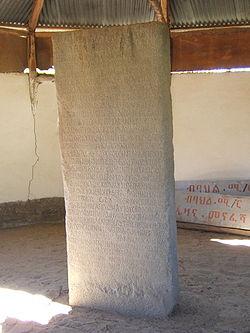
![]()
The Ezana Stone records negus
Ezana's conversion to Christianity and his
subjugation of various neighboring peoples, including Meroë.
Aksum remained a strong, though
weakened, empire and trading power until the rise of Islam
in the 7th century.
500
ad
Southern
Qi 479-502
Goguryeo or Koguryo (37 BC – 668 AD)
476
600
ce
Sui
dynasty
(581–618 AD) 
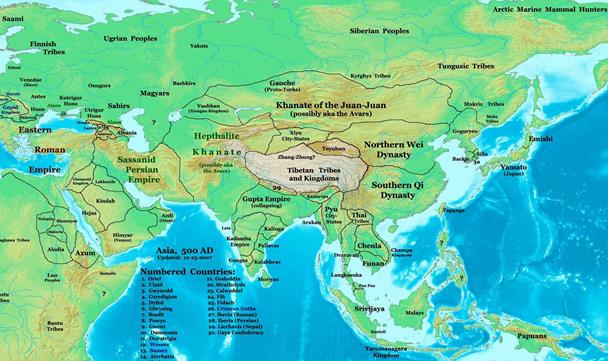
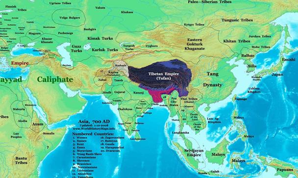
700
ce
Tibetan
empire 7th, 8th, and
9th centuries A.D 618-841
A civil
war that arose over Langdarma's successor led to the
collapse of the Tibetan Empire. The period that followed, known traditionally
as the Era of Fragmentation, was dominated by rebellions against the remnants
of imperial Tibet and the rise of regional warlords.[52]
Tang
(618–907 AD)
 700
700
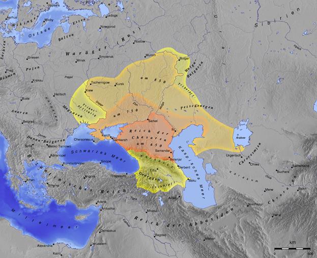
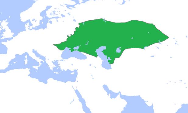
Khazars 618?–1048? For some three centuries (c. 650–965) the Khazars dominated the vast area extending from the Volga-Don steppes to the eastern Crimea and the northern Caucasus[13]
Khazaria long served as a buffer state between the Byzantine empire and both the nomads of the northern steppes and the Umayyad empire, after serving as Byzantium's proxy against the Sassanid Persian empire. The alliance was dropped around 900. Byzantium began to encourage the Alans to attack Khazaria and weaken its hold on Crimea and the Caucasus, while seeking to obtain an entente with the rising Rus' power to the north, which it aspired to convert to Christianity.[14] Between 965 and 969, the Kievan Rus ruler Sviatoslav I of Kiev conquered the capital Atil and destroyed the Khazar state.
800
ce
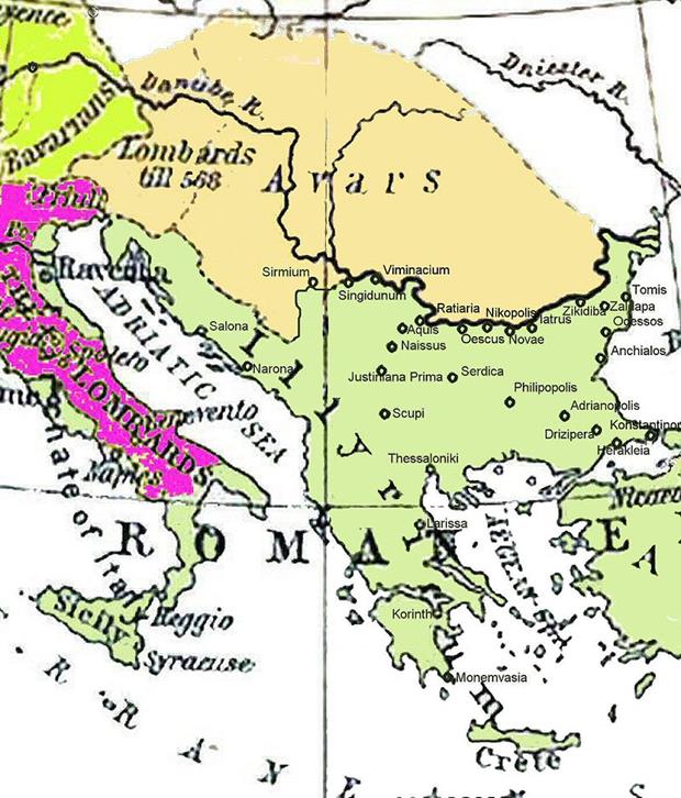
Avars Avar Khaganate was a nomadic
confederacy that was established in the Carpathian Basin region in 567 by the Avars, and lasted until 804 The gradual decline of Avar power accelerated
to a rapid fall within a decade. A series of Frankish campaigns in the 790s led
by Charlemagne ended with the conquest of the Avar realm, taking most of
Pannonia up to the Tisza River. Avar occupation was ended when
a Slavic-Croatian force led by prince Vojnomir and supported by the Franks launched a
counterattack in 791.[13][14]
The offensive was successful and the Avars were
driven out of Pannonian Croatia.[14]
Charlemagne won another major victory against the Avars
in 796.[15]
Around
800
900
ce
Khmer
900
ce
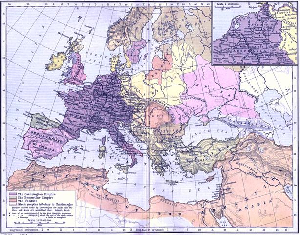
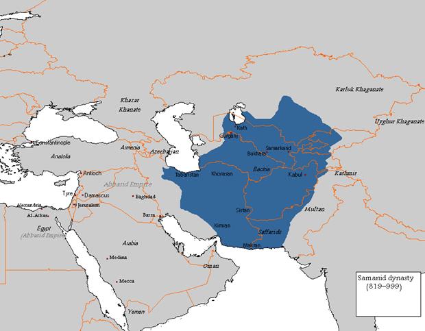
Samanid dynasty (Persian:
ÓÇãÇäیÇä, Sāmāniyān), also known as the Samanid Empire, or simply Samanids
(819–999)
Sistan
Sistan became a province of the Umayyad
and Abbasid Caliphates. In the 860s, the Saffarid dynasty
emerged in Sistan and proceeded to conquer most of
the Islamic East, until it was checked by the Samanids in 900. After the Samanids
took the province from the Saffarids, it briefly
returned to Abbasid control, but in 917 the governor Abu Yazid Khalid made himself independent. He was followed by a
series of emirs with brief reigns until 923, when Ahmad ibn Muhammad restored Saffarid
rule in Sistan. After his death in 963, Sistan was ruled by his son Khalaf ibn Ahmad
until 1002, when Mahmud of Ghazni invaded Sistan,
ending the Saffarid dynasty.
1000
ce
Kara-khanid khanate a
Turkic dynasty that ruled in Transoxania in Central Asia, ruled by a dynasty known in literature as the Karakhanids (also spelt Qarakhanids)
or Ilek Khanids
The Khanate conquered Transoxania in Central Asia and ruled it between 999–1211.[5][6] Their arrival in Transoxania signaled a definitive shift from Iranian to Turkic predominance in Central Asia,[7] but gradually the Kara-khanids became assimilated into the Perso-Arab Muslim culture of their realm.[8]
Their capitals included Kashgar, Balasagun, Uzgen and Samarkand
1000ce
Khitan Empire, Great Liao 907–1125 an empire in East Asia
that ruled over Mongolia and portions of the Russian Far East, northern Korea,
and northern China proper from 907 to 1125
1000ce
1100
ce
Almoravid
a Berber
dynasty
of Morocco,[1][2]
who formed an empire in the 11th century that stretched over the western Maghreb
and Al-Andalus.
Their capital was Marrakesh, a city they founded in 1062.
1120
ce
1200
ce
Southern
song
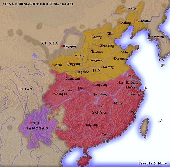
Jin dynasty (1115–1234)
also known as the Jurchen dynasty, was founded by the Wanyan clan of the Jurchens, the ancestors of the Manchus
who established the Qing dynasty some 500 years later
1141 ce
1200 ce
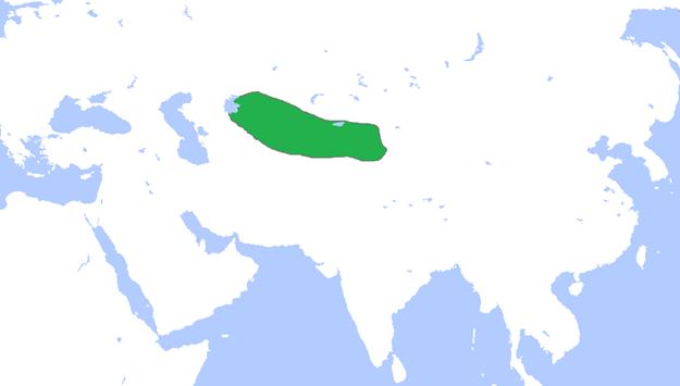
Kara-Khitan or
Qara-Khitai Khanate (Mongolian: Хар
Хятан;
Persian: خانات
قراختایی),
also known as Western
Liao 1124-1218 capital= Balasagun
Around 1200
Khwarezmid Empire
Main
article: Khwarezmid Empire
![]() he dynasty
ruled large parts of Greater
Iran during the High Middle Ages, in the approximate period of
1077 to 1231, first as vassals of the Seljuqs[8] and Kara-Khitan,[9] and later as independent rulers,
up until the Mongol invasion of Khwarezmia in the 13th century
he dynasty
ruled large parts of Greater
Iran during the High Middle Ages, in the approximate period of
1077 to 1231, first as vassals of the Seljuqs[8] and Kara-Khitan,[9] and later as independent rulers,
up until the Mongol invasion of Khwarezmia in the 13th century
In the 12th century, the Khwarezmid Empire was founded and, in the early
13th century, ruled over all of Persia under the Shah
ʿAlāʾ al-Dīn
Muhammad II
(1200–1220). In 1141, Yelü Dashi won the battle of Qatwan against a Seljuk army commanded by Sanjar, as a result, Khwarezm became a vassal of the Kara-Khitan Khanate.[24] Then from 1218 to 1220 Genghis Khan and his Mongols launched the invasion
of Central Asia
and destroyed the Kara-Khitan Khanate and the Khwarezmid Empire, including the splendid capital of the
latter, Gurganj.
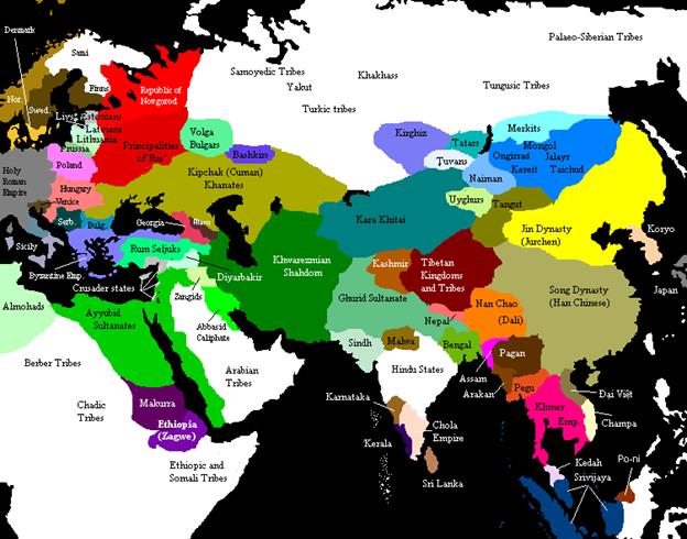
Political
map of Asia, Europe and Africa around 1200 AD showing the Khwarezmid
Empire in dark green
1300
Il-Khanate
1236-1335
The Ilkhanate,
also spelled Il-khanate (Persian: ایلخانان, Ilkhanan; Mongolian:
Хүлэгийн
улс, Hulagu-yn Ulus; Turkish:İlhanlı), was a Persianate breakaway Turco-Mongol khanate of the Mongol Empire, ruled by the Mongol
House of Hulagu. It was established in the
13th century and was based primarily in Persia
and neighboring territories, such as present-day Azerbaijan and the central and eastern
parts of present-day Turkey. Capital = Tabriz
Golden
horde
|
1240s–1502 |
|
Capital:
Sarai Batu
Holy
roman empire (not really)
After
the death of Frederick II in 1250, the German kingdom was divided between his
son Conrad
IV (died 1254)
and the anti-king, William
of Holland (died
1256). Conrad's death was followed by the Interregnum, during which no king could
achieve universal recognition, allowing the princes to consolidate their
holdings and become even more independent rulers. After 1257, the crown was
contested between Richard
of Cornwall, who
was supported by the Guelph party, and Alfonso
X of Castile,
who was recognized by the Hohenstaufen party but never set foot on German soil.
After Richard's death in 1273, the Interregnum ended with the unanimous
election of Rudolf
I of Germany, a
minor pro-Staufen count.
1400
Northern Yuan 1368-1691
Northern Yuan Dynasty[2] (official name:Khalkha Mongolian
: Mongol Uls, State of Mongolia; Khalkha Mongolian: ᠬᠦᠮᠠᠷᠳᠦ ᠥᠨ ᠥᠯᠥᠰ, Umard Yuan, Chinese: 北元; pinyin: Beǐ Yuán, Northern Yuan) was the successor state of the Yuan Dynasty that had retreated north to Mongolia after the expulsion from China in 1368
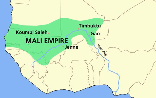
Mali
empire1230 to c.
1600. Musa III
In the early 15th century, Mali
was still powerful enough to conquer and settle new areas. One of these was Dioma, an area south of Niani
populated by Fula Wassoulounké.[16] Two noble brothers from Niani, of unknown lineage, went to Dioma
with an army and drove out the Fula Wassoulounké. The
oldest brother, Sérébandjougou, was crowned Mansa
Foamed or Mansa Musa
III. His reign
saw the first in a string of many great losses to Mali. In 1430, the Tuareg seized Timbuktu.[50] Three years later, Oualata also fell into their hands.[27]
Ottoman
empire capital=
|
|
1500
Northern
YuanRestoration (1479–1600)
Second
reunion
Manduul's (Manduulun)
young khatun Mandukhai proclaimed a boy named Batumongke. The new khan, as a descendant
of Genghis
Khan, took the
title Dayan meaning the "Great", with reference to the Yuan Dynasty.[22] Mandukhai
and Dayan Khan overthrew Oirat supremacy. At first the new rulers
operated with the taishi system. The taishis mostly ruled the Yellow River Mongols. However, one of them killed
Dayan Khan's son and revolted when Dayan Khan appointed his son, jinong Ulusbold,
over them. Dayan Khan finally defeated the southwestern Mongols in 1510 with
the assistance of his allies, Unebolad wang and the Four Oirats.[23] Making his another son jinong, he abolished old-Yuan court titles of taishi, chingsang, pingchan and chiyuan.
The Ming Dynasty closed
border-trade and killed his envoys. Dayan invaded China and subjugated the
Three Guards, tributaries of the Ming. The Oirats
assisted his campaign in China. The Tümed Mongols ruled in the Ordos region and they gradually
extended their domain into northeastern Qinghai.[24]
Administrative
divisions
Timurid dynasty 1370–1507
Capital=
Samarkand
By 1500,
the divided and wartorn Timurid
Empire had lost control of most of its territory and within the following years
were effectively pushed back on all fronts. Persia fell quickly to the Shiite Safavid dynasty, secured by Shah Ismail I in the following decade. Much of
the Central Asian lands was overrun by the Uzbeks of Muhammad Shaybani who conquered the key cities of Samarkand and Herat
in 1505 and 1507, and founded the Khanate
of Bukhara. From
Kabul, the Mughal
Empire was
established by Babur, a descendant of Timur through his father and possibly a descendant of Genghis Khan through his mother, in 1526. The
dynasty he established is commonly known as the Mughal dynasty though it was
directly inherited from the Timurids.
Golden
horde
Fall
(1480–1502) The
Kingdom of Poland and the Grand
Duchy of Lithuania
(which possessed much of the Ukraine at the time) were attacked in
1487–1491 by the remnant of the Golden Horde. They reached as far as Lublin
in eastern Poland before being decisively beaten at Zaslavl.[75]
The Crimean Khanate became a vassal state of the Ottoman Empire in 1475 and subjugated what
remained of the Great Horde, sacking Sarai in 1502. After seeking refuge in
Lithuania, Sheikh Ahmed, last Khan of the Horde, died in prison in Kaunas
some time after 1504.
Southeast Asian Polities
v. 11-3-15
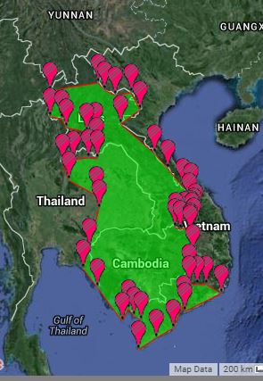
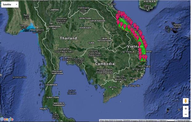
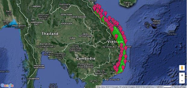
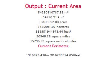
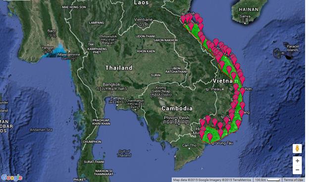
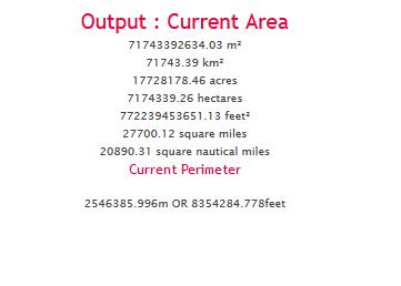
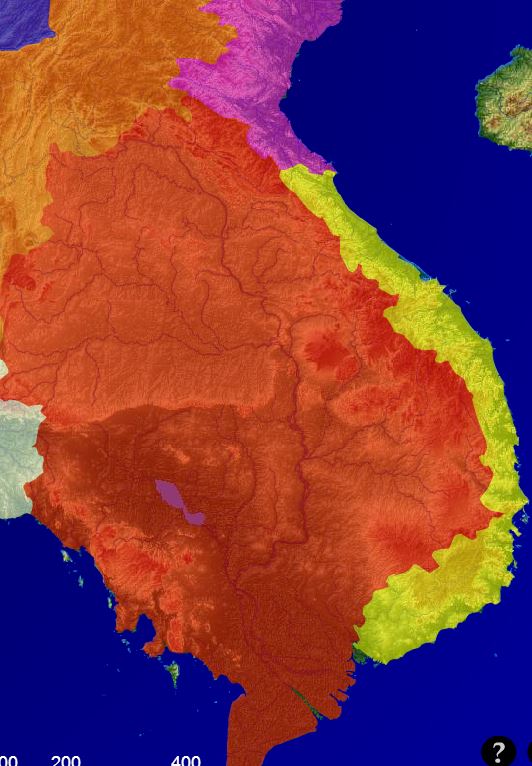
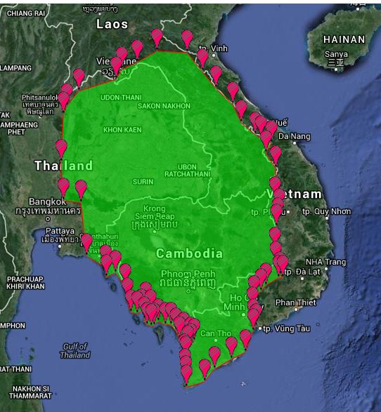
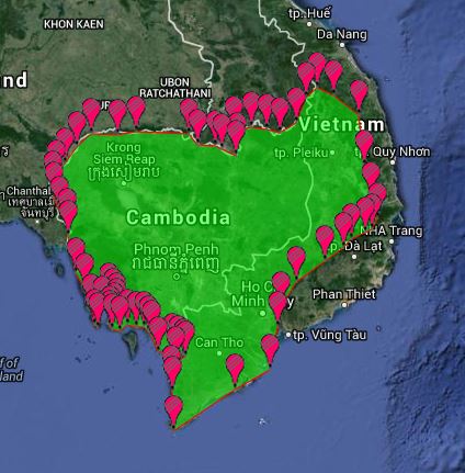
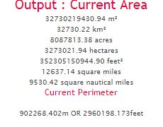
Polygon making: To calculate the area (sq megameters) of a polity or other entity find a map that shows the entity And put it in a window beside the map from daft logic.
http://www.daftlogic.com/projects-google-maps-area-calculator-tool.htm
open window of map. Within daftlogic zoom to same area. Put in polygon markers
to convert square kilometers to square megameters multiply times .000001
a square megameter is 1000 by 1000 kilometers.
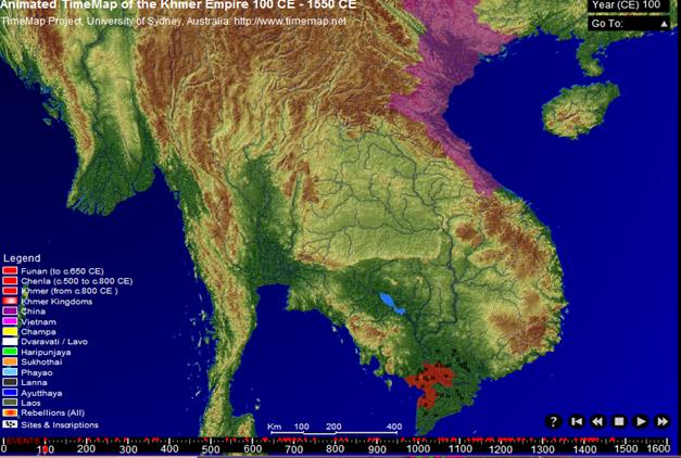
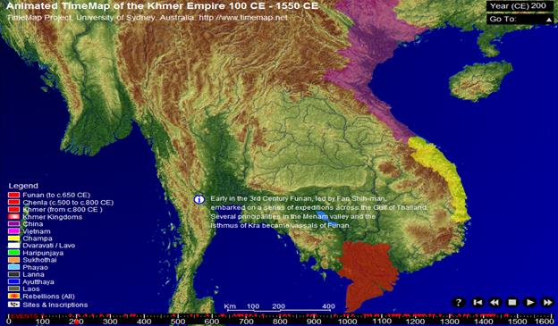
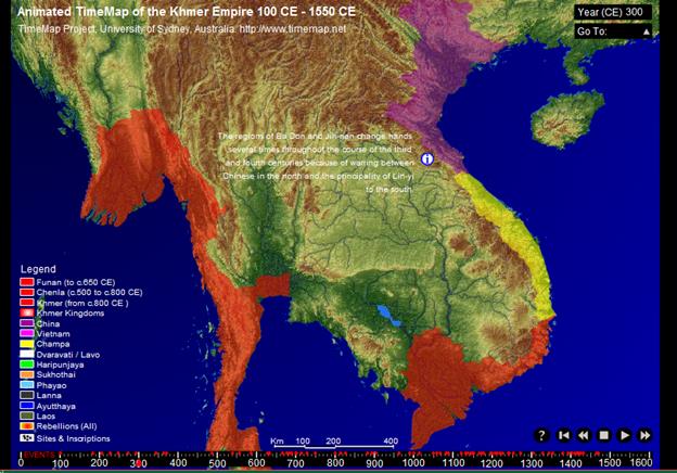
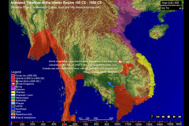
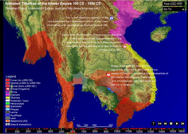
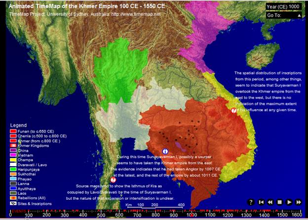
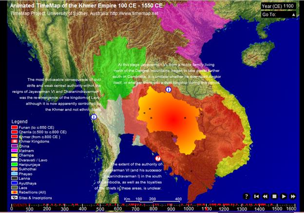
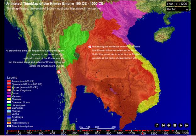
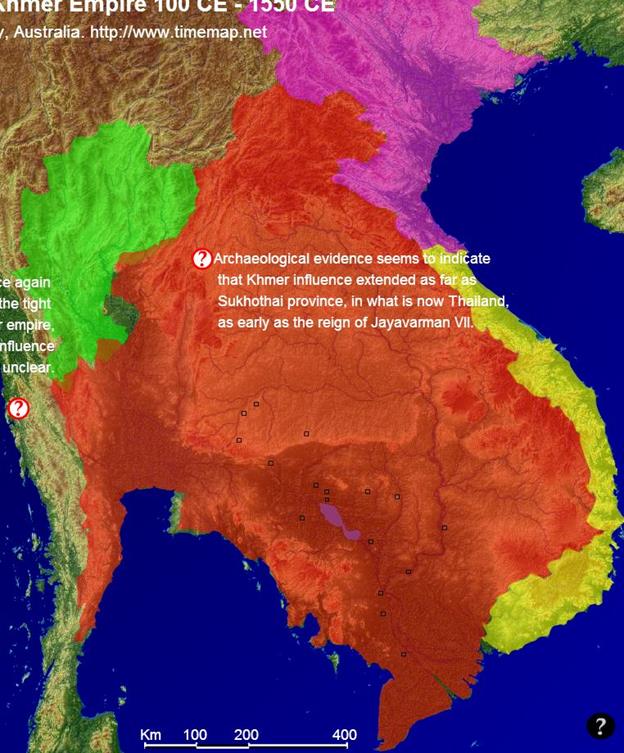
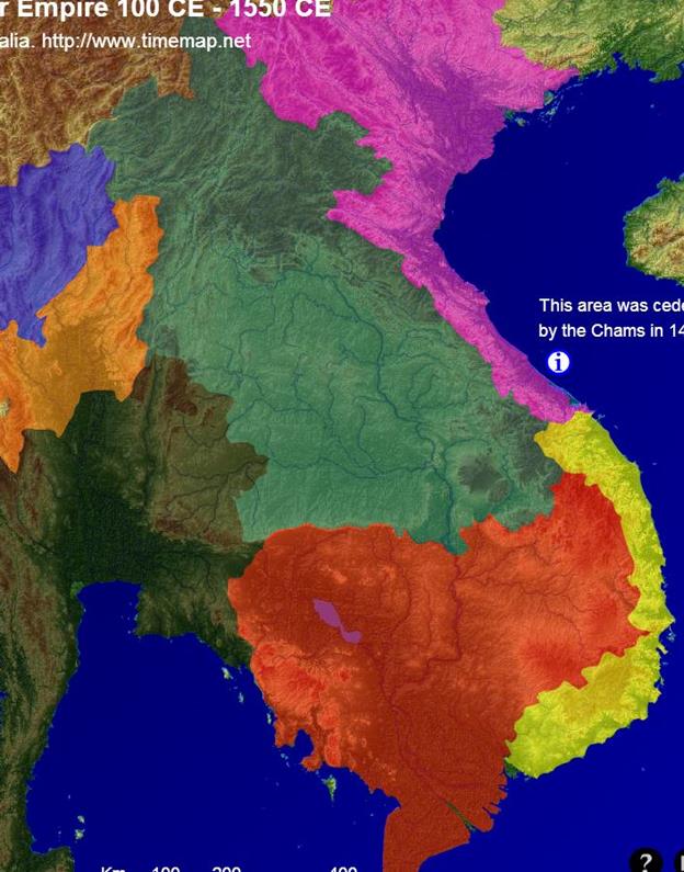
http://sydney.edu.au/arts/timemap/images/content/timemap/examples/2003_03_khmer_animation.swf
Chandler,
David 1996 A History of Cambodia. Boulder, CO: Westview Press.
Coe, Michael D. 2003 Angkor and the Khmer
Civilization. New York: Thames and Hudson.
Lieberman, Victor. 2003. Strange Parallels:
Southeast Asia in Global Context, c. 800-1830. Vol. 1: Integration on the
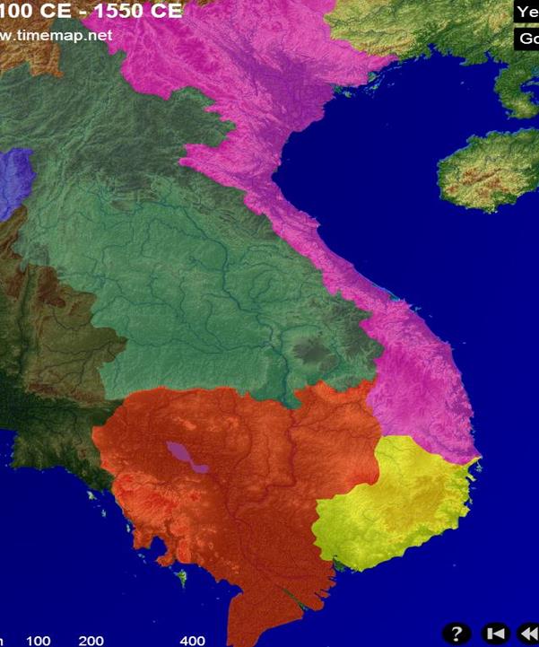
Mainland. Cambridge: Cambridge University Press.
100CE “Funan”
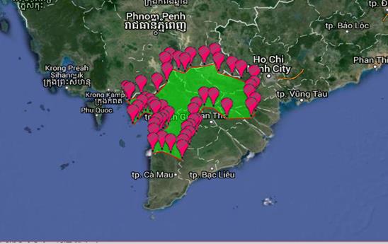
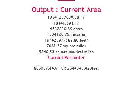
“Funan” 100CE 0.0183411821 SQ. Mega Meters
200CE
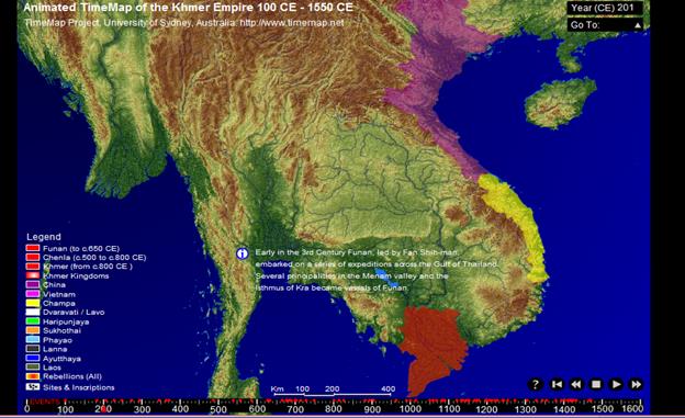
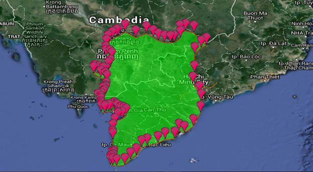
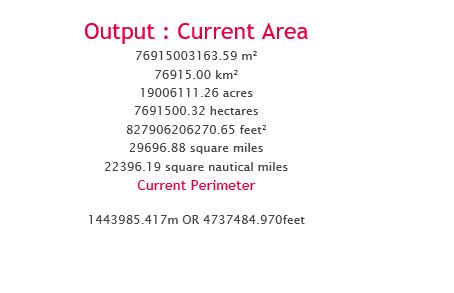
“Funan” 200CE 0.076914566114 sq. Mega Meters
Funan polity
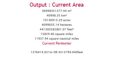
300 CE
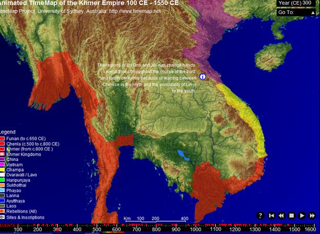
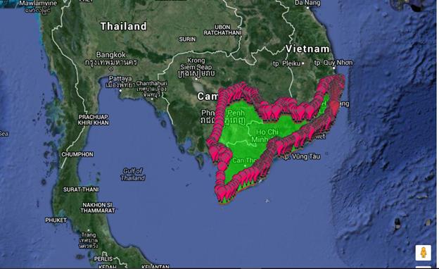
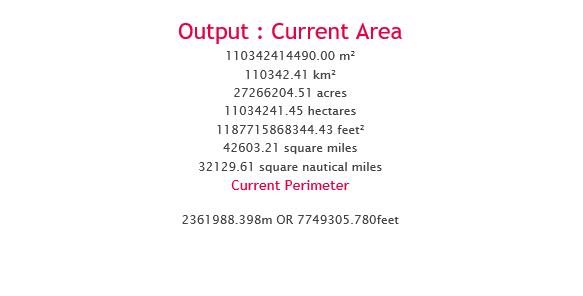
“Funan”
in 300 CE 0.11034180736 Square Mega Meters
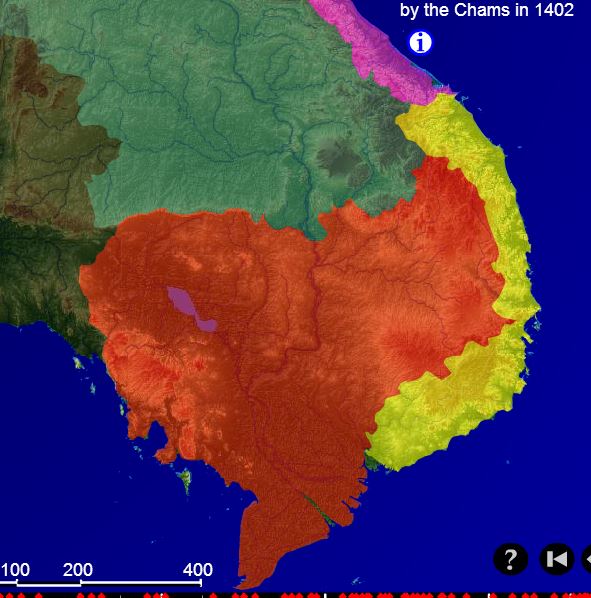
The term Champa
refers to a collection of independent Cham<https://en.wikipedia.org/wiki/Chams> polities that
extended across the coast of what is today central and southern Vietnam<https://en.wikipedia.org/wiki/Vietnam> from
approximately the 7th century through 1832, before being conquered and annexed
by Vietnam
Champa reached its apogee in the 9th and 10th
centuries. Thereafter, it began a gradual decline under pressure from Đại Việt<https://en.wikipedia.org/wiki/%C4%90%E1%BA%A1i_Vi%E1%BB%87t>,
the Vietnamese polity centred in the region of modern
Hanoi<https://en.wikipedia.org/wiki/Hanoi>. In 1832, the
Vietnamese emperor Minh Mạng<https://en.wikipedia.org/wiki/Minh_M%E1%BA%A1ng>
annexed the remaining Cham territories.
Modern scholarship has been guided by two competing theories in the
historiography of Champa. Scholars agree that
historically Champa was divided into several regions
or principalities spread out from south to north along the coast of modern
Vietnam and united by a common language, culture, and heritage. It is
acknowledged that the historical record is not equally rich for each of the
regions in every historical period. For example, in the 10th century, the
record is richest for Indrapura; in the 12th century,
it is richest for Vijaya<https://en.wikipedia.org/wiki/Vijaya_%28Champa%29>;
following the 15th century, it is richest for Panduranga.
Some scholars have taken these shifts in the historical record to reflect the
movement of the Cham capital from one location to another. According to such
scholars, if the 10th-century record is richest for Indrapura,
it is so because at that time Indrapura was the
capital of Champa. Other scholars have disputed this
contention, holding that Champa was never a united
country, and arguing that the presence of a particularly rich historical record
for a given region in a given period is no basis for claiming that the region
functioned as the capital of a united Champa during
that period.[5]https://en.wikipedia.org/wiki/Champa#cite_note-5
Funan in 400 CE
Same as in 300
Chenla 600
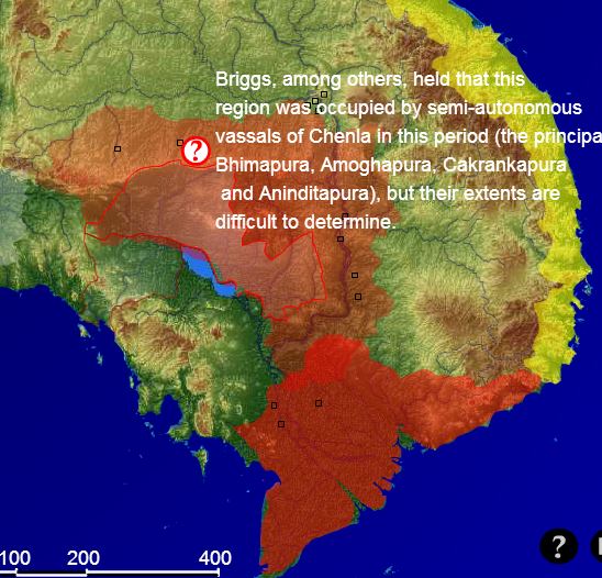
.0928 sq
km chenla 600
Chenla 700
.5806 sq
megameters in 700
Champa kingdom [192-1700](Vietnam)
Champa was formed in AD 192, during the breakup of the Han dynasty of
China, when the Han official in charge of the region established his own
kingdom around the area of the present city of Hue. Although the territory was
at first inhabited mainly by wild tribes involved in incessant struggles with
the Chinese colonies in Tonkin, it gradually came under Indian cultural
influence, evolving into a decentralized country composed of four small states,
named after regions of India, Amaravati (Quang Nam), Vijaya (Binh Dinh),
Kauthara (Nha Trang), and Panduranga (Phan Rang). The four states had a powerful
fleet that was used for commerce and for piracy. The Cham people, of
Malayo-Polynesian stock and Indianized culture, were
finally united under the rule of King Bhadravarman
around 400AD.
In
retaliation for Cham raids on their coast, the Chinese invaded Champa in 446, bringing the region under their suzerainty
once again. Finally, under a new dynasty in the 6th century, Champa threw off its allegiance to China and entered into
an era of great independent prosperity and artistic achievements. In the late
8th century the Chams were distracted by attacks from
Java, but in the 9th century they renewed their pressure on the Chinese
provinces to the north and the growing Khmer Empire to the west.
Under Indravarman II, who established the Indrapura dynasty in 875, the capital of the country was
moved to the northern province of Amaravati (Quang
Nam), near present Hue, and elaborate palaces and temples were constructed.
In
the 10th century the Vietnamese kingdom of Dai Viet, based in Hanoi, began
to exert pressure on Champa, forcing it to relinquish
Amaravati in 1000 and Vijaya in 1069. Harivarman IV, who founded the ninth Cham dynasty in 1074,
was able to stave off further Vietnamese and Cambodian attacks, but in 1145 the
Khmers, under the aggressive leadership of Suryavarman
II, invaded and conquered Champa. Two years later a
new Cham king, Jaya Harivarman I, arose and threw off
Khmer rule, and his successor sacked the Cambodian capital at Angkor in 1177.
Between 1190 and 1220 the Chams again came under
Cambodian suzerainty, and later in the 13th century they were attacked by the Tran kings of Vietnam, as
well as by the Mongols in 1284. By the late 15th century, incessant wars of
aggression and defense had for all practical purposes wiped out the Champa kingdom; one by one their provinces were annexed
until Champa was entirely absorbed in the 17th
century.
Champa
200 ce
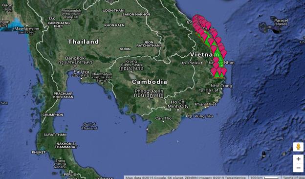
Whole
of Champa in 200 CE0.022350406 square mega meters
Champa 300 ce
Whole
of champa in 300 ce is 0.040998113193
square mega meters
400 CE Champa
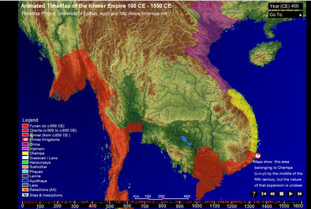
Funan is bigger
500
Funan is bigger
600
Champa in 600 ce 0.054250616156
sq. mega meters
Same with 700
Chenla is larger
700
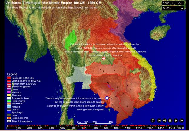
Champa in 700 ce 0.054250616156
sq. mega meters
Same with 600 c
800
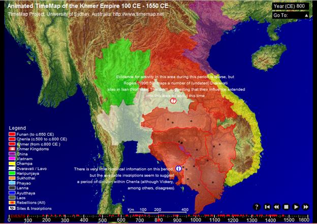
0.071742981455 sq. mega
meters
900

Khmer is bigger
1000
1100
1200
http://berclo.net/page00/00en-sea-history.html
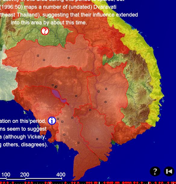
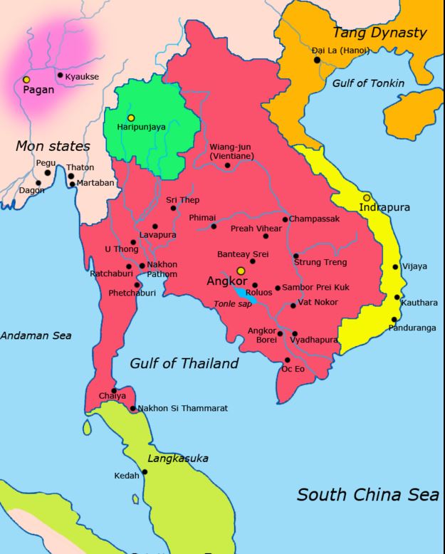
Khmer kingdom [802-1432](Cambodia)
Khmer civilization developed over several distinct periods. The
first was marked by the small, somewhat decentralized Hindu-Buddhist kingdoms
of Funan and Chenla,
beginning in the 1st century AD and extending into the 8th century.
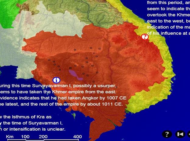
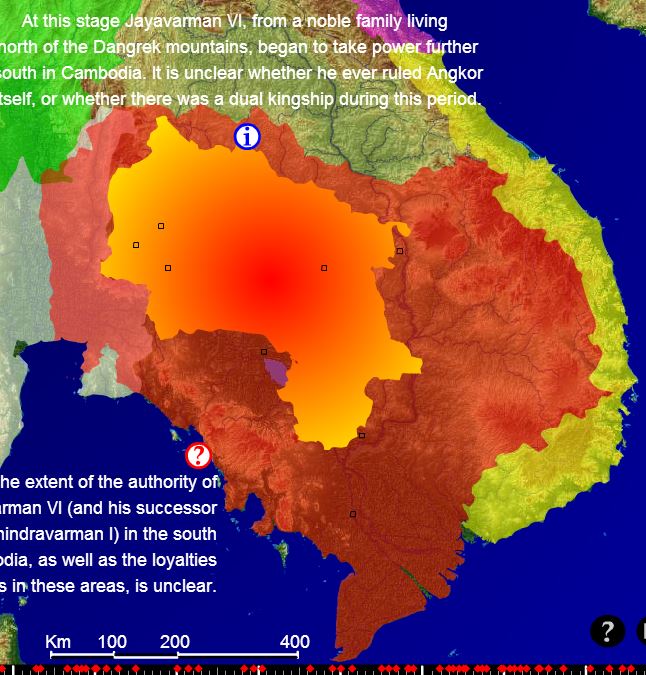
In the late 8th and early 9th centuries, Jayavarman
II founded the dynasty that became established at Angkor by the early 10th
century. This era has been called the classical period of Khmer civilization
(802-1432). Jayavarman's successors constructed great
architectural monuments at Angkor. The power of the Khmer empire peaked in the
12th century under Suryavarman II, who built the
temple complex of Angkor Wat. His armies ranged as far west as northern
Thailand and as far east as northern Vietnam. The Khmer empire's strength was
based on a well-developed system of irrigated rice cultivation and on an
elaborate bureaucracy that exerted control over Khmer manpower. In the early
13th century, Jayavarman VII extended the empire
farther than had any of his predecessors.
The Empire crumbled later in the 13th and 14th centuries when
domestic instability caused by the accession of weak rulers left the Khmer
exposed to the attacks of their neighbours. Their
difficulties were compounded when Buddhism began to undermine the hierarchy of
the state, which was based on Hinduism. By the 15th century the Khmer could no
longer defend their capital at Angkor. The next 400 years were a period of
political and social decline in which Khmer rulers were often involved in wars
with Vietnam and Siam. Many times the Khmer rulers became vassals of one or the
other.
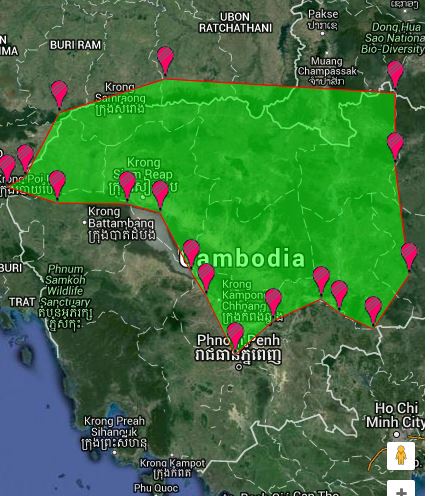
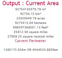
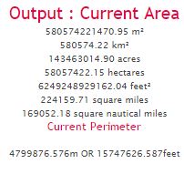
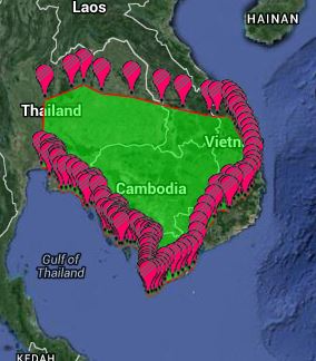
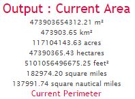
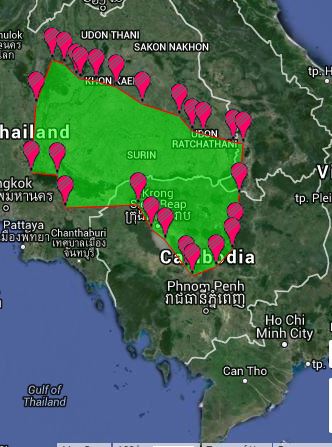
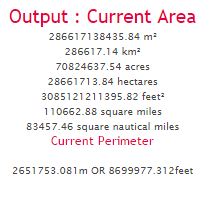
Khmer Empire 802 CE
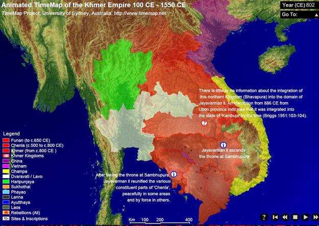
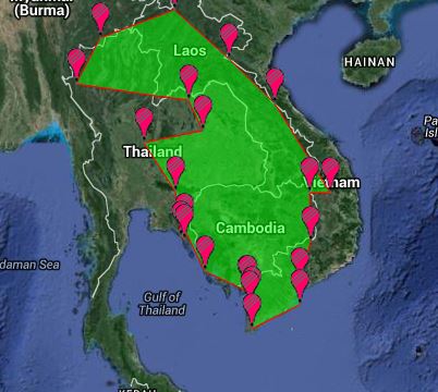
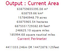 Khmer Empire 802 CE .638759 sq megameters
Khmer Empire 900 CE
https://en.wikipedia.org/wiki/Khmer_Empire#/media/File:Map-of-southeast-asia_900_CE.png
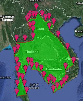
 khmer empire 900CE= .910376 sq megameters
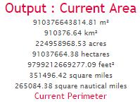
Khmer empire1000 CE
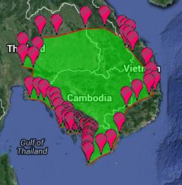
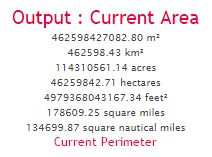
Khmer empire 1000 CE =.462598
sq megameters 1000 CE
Srivajaya
larger at .6807
1100 CE khmer empire
1100 khmer outside
Outside area= .473903 sq megameters
Rebellious area inside= .139846 sq megameters
So 1100 CE khmer outside (.473903) minus rebellious area inside (.139846)= .334057 sq megameters
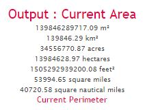
Khmer 1200 CE
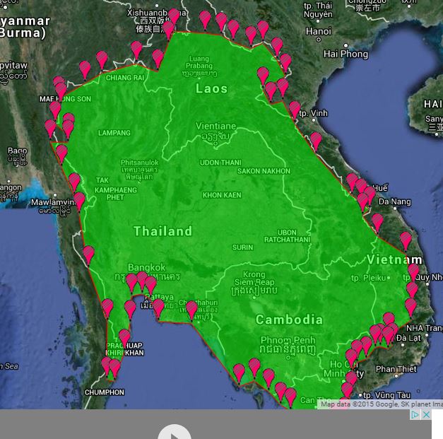
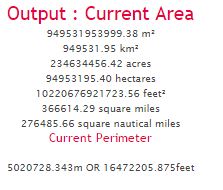
.949531 sq megameters for 1200 Ce
1300 CE
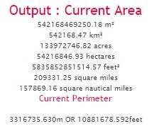
So .542168 sq megameters in 1300 CE
Khmer .286617 sq megameters in 1400 CE. 1432 sacked by Ahutya
Same in 1500 CE Cambodia
Same in 1600 CE (Geacron) Cambodia
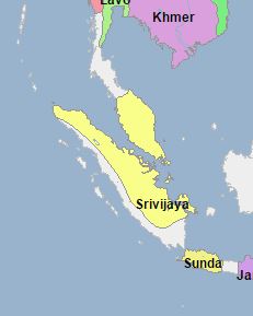
Srivajaya
800 CE
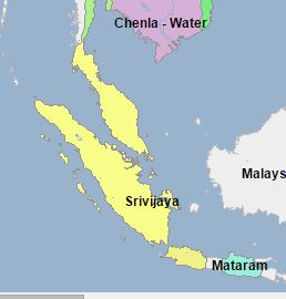
Geacron 800
Srivajaya malay part
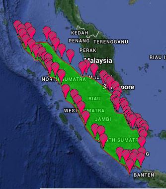
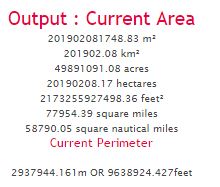
Srivajay 800 sumatra part
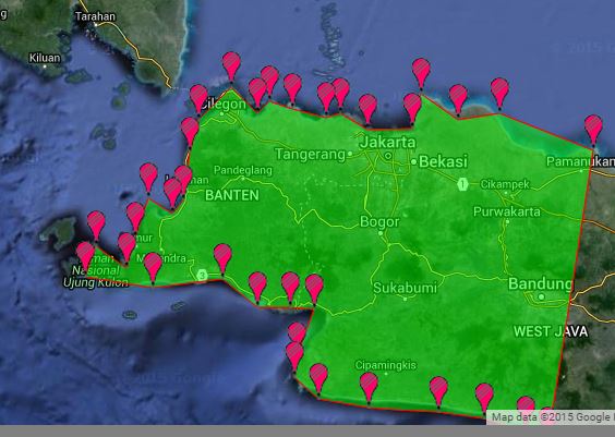
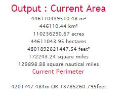
Srivajay 800 west java part
Malay part = .201902
Sumatra= = .44611
West java= .03273 total = .680742 sq megameters in 800 CE for Srivajaya
Bigger than khmer: Khmer Empire 802 CE .638759 sq megameters
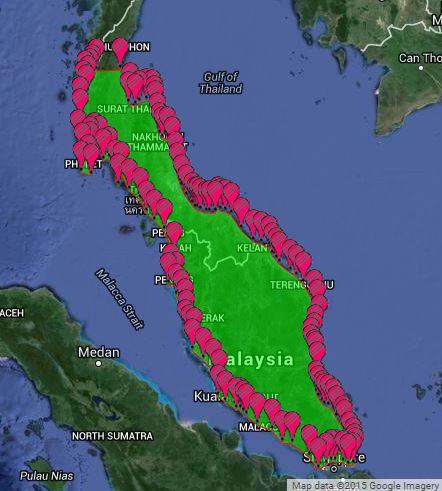
Srivajaya 1100
Malay part 132584.59 km²
Sumatra part 328772.24 km²
Banka-belatung island
12498.63 km²
473854 sq kms = .473854
Laos (Lan Xang) 1400
Wikipedia Lan Xang in green. 1400 CE
Sydney
Lan xang 1400 ce
392755.52 km²= .3928 sq megameters
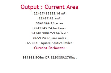
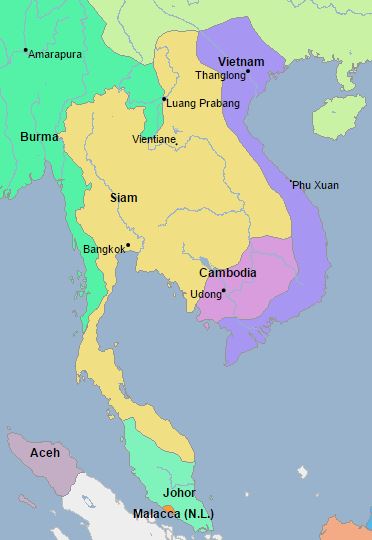
Vietnam 1500 CE
246194.44 km²= .2462 sq megameters for Vietnam in 1500
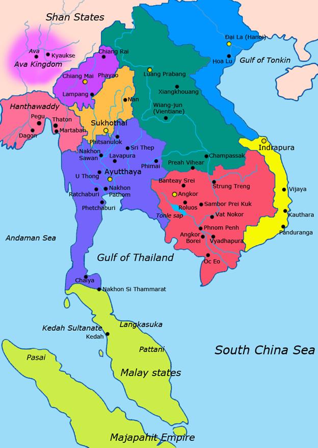
Ayutthaya 1600 ce

311011.49 km²= .3110 sq megameters
Ayutthaya
1700
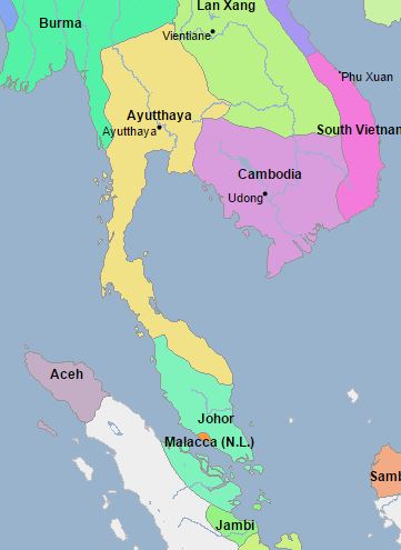
Ayutthaya 1700 ce 431775.26
km² .431775 sq megameters
Siam
1800
Siam
1800 785268.19 km² .785268 sq megameters
Siam 1900
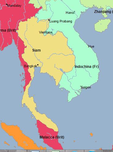
Siam 1900 .607098 sq megameters
Indonesia 2000 ce 1,904,569 km2 1.9045 sq megameters
SE Asia from 100 CE to 1700 CE Largest Polity
Year Polity size in sq megameters 2nd largest polity
100 CE “Funan” .0183
200 Ce “Funan” .0769
300 ce “Funan” .1103
400 CE “Funan” .1103
500 CE “Funan” .1103
600 CE Chenla .0928
700 CE Chenla .5806
800 CE Srivajaya .6807 Khmer = .6387
900 CE Khmer .9104
1000 CE Srivajaya .6807 Khmer= .4626
1100 CE Srivjaya .4738 Khmer .3341
1200 CE Khmer .9495
1300 CE Khmer .5422
1400 CE Lan Xang (Laos) .3928 Khmer= .2866
1500 CE Lan Xang .3928 Vietnam .2462
1600 CE Lan Xang (Laos) .3928 Ayutthaya .3110
1700 CE Ayutthaya .4318 Lan Xang (Laos) .3928
1800 CE Siam .7853
1900 CE Siam .6071
2000 CE Indonesia 1.9045
Figure showing the logged values to the sum of the largest
cities and polities
Figure 10:
Logged sum of the populations of the world’s 6 largest cities and 6 largest
polities, 1500 BCE to 2010 CE
Figure 10 shows the logged sums of the populations of the
world six largest cities and of the world six largest polities from 1500 BCE to
2010 CE. The long-term upward trends for
both are clear, but there are interesting temporary declines in both. And the
final twists are different. Polity sizes decline because of decolonization,
while city sizes show a rapid increase, even when they are converted to log
scores.
Redo this using the
world sum of largest cities and polities in 10 world regions