Uneven Urban Development:
Largest Cities since the Late Bronze Age*
Christopher
Chase-Dunn, Hiroko Inoue,
Alexis
Alvarez, Rebecca Alvarez, E. N. Anderson and Teresa Neal
Institute
for Research on World-Systems
University
of California, Riverside
Yin, the last
capital of the Shang dynasty
An earlier version was presented at the annual conference of the American Sociological Association, Chicago, August 24, 2015. v. 8-30-15, 11312 words
*We are indebted to those
intrepid estimators of the population sizes of cities who made quantitative
studies possible: Tertius Chandler, George Modelski and Ian Morris. Thanks also to Dmytro Khutkyy for
helpful comments and suggestions on an earlier draft.
![]()
This
is IROWS Working Paper # 98 available at https://irows.ucr.edu/papers/irows98/irows98.htm
Data appendix for this paper is at https://irows.ucr.edu/cd/appendices/worregs/worregsapp.htm
Abstract:
This is a study of the growth of settlements in ten world regions over the past 3500 years. We compare East Asian urban growth with the original heartland of cities and states in West Asia and North Africa, as well as Europe, the subcontinent of South Asia, Central Asia, Southeast Asia and the Americas. This quantitative study of the trajectories of city growth and the changing relative scale of social organization in the different world regions provides an overall picture of the long-term patterns of uneven development in human sociocultural evolution and has important implications for prehension of the similarities and differences between the developmental trajectories of the world regions studied. This paper focusses mainly on the age-old comparison between East Asia and the West.
The
study of the long-run growth of settlements and polities is an important basis
of our understanding of comparative sociology and human sociocultural
evolution.[1] The processes by which a world inhabited by
small nomadic hunter-gatherer bands became the single global political economy
of today involved the establishment and growth of settlements, the expansion of
interaction networks and the growing size of polities. These processes of
long-term growth and expansion were uneven in time and space. There were cycles of growth and decline. And
some of those regions that originally developed larger cities and polities
were, in later epochs, no longer the leading regions.
Our
theoretical approach is the institutional
materialist comparative evolutionary world-systems perspective. World-systems are defined as being composed of those human
settlements[2]
and polities [3]
within a region that are importantly interacting with one
another. Important interaction means that there are consequences for the
reproduction or change in local social structures. This approach focuses
on the ways that humans have organized social production and distribution, and
how economic, political, and religious institutions have evolved in systems of
interacting polities (world-systems) since the Paleolithic Age. We employ an
underlying model in which population pressures and interpolity
competition and conflict have always been, and still remain, important causes
of social change, while the systemic logics of social reproduction and growth
have gone through qualitative transformations[4]
(Chase-Dunn and Lerro 2014: Chapter 2). Our larger
research project studies the development of settlements and polities by
comparing regional world-systems and studying them over long periods of time.[5]
Our approach to the spatial bounding of the
unit of analysis is very different from those who try to comprehend a single
global system that has existed for thousands of years. Gerhard Lenski (2005); Andre Gunder Frank
and Barry Gills (1994) and George Modelski (2002; and
Modelski, Devezas and
Thompson 2008) and Sing Chew (2001;2007)
all analyze the entire globe as a single system over the past several
thousand years. We contend that this approach misses very important differences
in the nature and timing of the development of complexity and hierarchy in
different world regions. Combining apples and oranges into a single global bowl
of fruit is a major mistake that makes it more difficult to both describe and explain
social change. Our comparison of different world regions and interaction
networks of polities makes it possible to discover both their similarities and
the differences. Global comparisons among these regional systems are certainly
appropriate, but the claim that there has always been a single global
world-system is profoundly misleading. [6]
Our earlier studies have used data on city sizes and the territorial sizes of empires to examine and compare different regional interaction systems (e.g. Chase-Dunn, Manning and Hall 2000; Chase-Dunn and Manning 2002; Inoue et al 2012; Inoue et al 2015). This article is a re-examination of the city size data that uses better estimates and that will enable us to address claims about the relative importance of China and Europe that have been advanced by Andre Gunder Frank (1998) and more recently by Ian Morris (2010; 2012) and to reflect on the similarities and differences of the trajectories of development in the ten world regions we are studying.
The question we will try to answer in
this article is: what can patterns of settlement growth tell us about the
trajectories of development of the different world regions and the expanding
Central System? This paper is the first
part of a study that will also use the sizes of largest polities in world
regions to examine the nature of uneven development. But this paper looks only
at the sizes of the largest city in each world region.
The issue of systemness and the spatial boundaries of whole human
systems remains contentious in social science. The description of Earth-wide
“global” history and processes is certainly a valid exercise, but the question
of bounding whole systems is more complicated. It depends on what is meant by systemness. The idea of a whole system requires being
explicit about what is within the system and what is designated as exogenous.
Some explicit world-systems theoretical approaches claim that the whole of
humanity has constituted a single world-system since the emergence of modern
humans. This position has been explicitly taken by Gerhard Lenski
(2005). Andre Gunder Frank and Barry Gills (1994)
contended that what they call “the world system” emerged when states and
cities arose in Mesopotamia 5000 years
ago. Frank and Gills (1993:16,84-85)
designated a number of turning points of gradual inclusion of world regions
into the world system. Five thousand years ago it was constituted only
as Egypt and Mesopotamia, but China and the rest of Eurasia became part of the
system around 500 BC, and the incorporation of Americas occurred after 1492. Their position
was adopted by Sing Chew 2001; 2007).
Immanuel Wallerstein (2011[1974]) contended that the modern
world-system was not yet global when it emerged in Europe and the Americas in
the long 16th century CE. Chase-Dunn and Hall (1993;1997) defined
world-systems as human interaction networks in which the interactions were,
consequential, two-way and regular. They adopted a place-centric approach to
spatially bounding world-systems because of the observation that all human
groups interact with their neighbors and so if you count all indirect
connections there has been a single linked network since the humans populated
the continents. The ideas of “fall-off” of effects of interaction and
place-centricity were adopted from archeology.
The study of world
regions that we have undertaken here is not meant to confound the spatial
bounding of whole human interaction systems by means of interaction networks.
Rather it is intended to shed light on the literature that has emerged from the
critique of Eurocentrism and the rise of other centrisms.
We acknowledge that Eurocentrism has had huge detrimental effects on the
efforts of social scientists to describe and explain human sociocultural
evolution. And we agree that looking at reality from different perspectives is
a valuable exercise that can be enlightening and make big contributions to the
effort to explain the human past and present. We contend that the
methodological approach developed by Chase-Dunn and Hall for spatially bounding
world-systems is capable of providing a non-centric or cosmocentric
method for comparing small, medium-sized and large (global) human systems. This
said, we admit that important work still needs to be done to accurately specify
the timing and location of changes in the spatial boundaries of world-systems
(see Chase-Dunn et al 2015).
Relative Regional Complexity
Andre
Gunder Frank’s (1998) provocative study of the global
economy from 1400 to 1800 CE contended
that China had long been the center of an already global system. Frank also
argued that the rise of European power was a sudden and conjunctural development
caused by the emergence in 18th century China of a “high level
equilibrium trap” and the success of Europeans in using bullion extracted from
the Americas to buy their way into Chinese technological, financial and
productive success. Frank contended that
European hegemony was fragile from the start and will be short-lived with a
predicted new rise of Chinese global predominance in the near future. He also
argued that scholarly ignorance of the importance of China invalidates all the
social science theories that have mistakenly characterized the rise of the West
and the differences between the East and the West. In Frank’s view there never
was a transition from feudalism to capitalism that distinguished Europe from
other regions of the world. He argued that the basic dynamics of development
have been similar in the single global system for 5000 years (Frank and Gills
1994).
A
related effort to compare world regions as a window on relative sociocultural
evolution is contained in two recent books by Ian Morris (2010; 2012). Morris’s big idea is
that complex human systems, like other complex systems, need to capture free
energy in order to support greater scale and complexity, and that the ability
to capture free energy is the main variable that accounts for the growth of
cities and empires in human history. Morris traces the increasing size of human
settlements since the origins of sedentism in the
Levant about 12,000 years ago. And he uses estimates of the sizes of the
largest settlements in world regions as a main indicator of system complexity.
Using this method he notes that there was parallel evolution of sociocultural
complexity in Western Asia and Northern Africa, South Asia, East Asia, the
Andes and Mesoamerica, and that the leading edge of the development of
complexity diffused also from its points of origin. And sometimes the original
centers of complexity lost pride of place because new centers emerged out on
the edge. The Bronze Age Mesopotamian heartland of cities now has none of the
world’s largest cities. Development was spatially uneven in some regions, with
the center moving to new areas.
In the introductory chapter of The Measure of Civilization Morris
provides a useful overview of earlier efforts to measure social development,
and he also provides a helpful and insightful discussion of the social science
literature on sociocultural evolution since Herbert Spencer. Morris’s research
is unusual for an historian because he carefully defines his concepts,
specifies his assumptions and operationalizes his measures, and then uses the
best quantitative estimates of settlement sizes as the main basis of the story
he is telling. His estimates of the sizes of the largest cities utilize and
improve upon earlier compendia of city sizes.
The main focus of Morris’s Why the West Rules is the comparison of
what happened in Western Asia, the Mediterranean and Europe with what happened
in East Asia. Morris is careful to trace the histories of the diffusion of
complexity in both areas. He also makes contemporaneous comparisons of the two
regions which allow us to see that there has been a see-saw pattern back and
forth regarding which region was ahead or behind in the development of
sociocultural complexity. The “West” (Western
Asia and North Africa in the Bronze Age and then including the rest of the
Mediterranean and Europe)[7]
had a head-start, but the East caught up and passed, and then the West (Europe
and North America) passed the East again.
Morris’s emphasis on energy capture is a valuable materialist angle and
the focus on cities rather than polities or civilizations allows us to see
important patterns more clearly.
While
The Measure of Civilization is about
the quantitative basis of Morris’s analysis, Why the West Rules adds a lot of detail beyond the basic focus on
energy capture. But the energy capture
idea misses some of the patterns that are of interest to those who want to study
whole world-systems over long historical time. The story tends to be rather
core-centric with little attention paid to the transformative roles played by
peripheral and semiperipheral marcher states and
city-states in the construction of large empires and the expansion of trade
networks. Morris does not discuss the
transformation of systemic logics of development over the long period he
studied, or how differences in the development of capitalism may have been an important
contributor to the rise of Europe. But
the foregrounding of energy and cities is a valuable materialist strategy for
comprehending both the patterns of history and for considering the present and
the future of human sociocultural development.
Immanuel
Wallerstein’s (2011 [1974]) analysis of East-West
similarities and differences that account for the rise of predominant
capitalism in Europe and the continued predominance of the tributary logic in
East Asia is presented in Chapter One of Volume 1 of The Modern World-System. Summing up his detailed discussion of the
main factors that account for the East/West divergence, Wallerstein says:
The essential difference between China and
Europe reflects once again the conjuncture of a secular trend with a more
immediate economic cycle. The long-term secular trend goes back to the ancient
empires of Rome and China, the ways in which and the degree to which they
disintegrated. While the Roman framework remained a thin memory whose medieval
reality was mediated largely by a common church, the Chinese managed to retain
an imperial political structure, albeit a weakened one. This was the difference
between a feudal system and a world-empire based on a prebendal
bureaucracy. China could maintain a more advanced economy in many ways than
Europe as a result of this. And quite possibly the degree of exploitation of
the peasantry over a thousand years was less. To this given, we must add the
more recent agronomic thrusts of each, of Europe toward cattle and wheat, and
of China toward rice. The latter requiring less space but more men, the secular
pinch hit the two systems in different ways. Europe needed to expand
geographically more than China did. And to the extent that some groups in China
might have found expansion rewarding, they were restrained by the fact that
crucial decisions were centralized in an imperial framework that had to concern
itself first and foremost with short-run maintenance of the political
equilibrium of its world-system. So China, if anything seemingly better placed prima
facie to move forward to capitalism in terms of already having an extensive
state bureaucracy, being further advanced in terms of the monetization of the
economy and possibly of technology as well, was nonetheless less well placed
after all. It was burdened by an imperial political structure (p. 63).
We
now know much more about China because of the careful comparative work of the
“California School” of world historians (e.g., Bin Wong 1997; Kenneth Pomeranz 2001) and Giovanni Arrighi’s
Adam Smith in Beijing (2007) as well
as the important collection of essays in Arrighi, Hamashita, and Selden (2003). But Wallerstein’s analysis of the main elements explaining the
East/West divergence since the sixteenth century is still the best because of
its fruitful combination of millennial and conjunctural
time scales.
Frank’s
model of development in Reorient focuses mainly on state expansion and
financial accumulation. His study of global flows of specie, especially silver,
was an important contribution to our understanding of what happened between
1400 and 1800 CE (see also Flynn 1996).
Frank also uses demographic weight, and especially population growth and
growth of the size of cities, as an indicator of relative developmental
success.
It
is our intention to systematically examine the growth of the largest cities in
order to shed more light on Frank’s claims about the relative development of
East and West. Our study will begin in 1500 BCE when we first have reliable and
comparable datings for of the population sizes of
cities and the territorial sizes of states and empires in different world
regions.
Chronologies for Comparative Analysis
For purposes of comparing the timing of changes
in city sizes across different world regions it is important to have accurate
absolute chronologies for the regions being compared. Unfortunately there is
still considerable disagreement about the absolute dating for Mesopotamia
before 1500 BCE. Mario Liverani (2014: 9-16) explains
why estimates of absolute dates are so uncertain. Relative dates of events
needed for estimating polity sizes are based on “king lists.” Thus an event,
such as a conquest, is said to have occurred in the third year of the reign of
King X. Considerable effort has been made to figure out the correspondences
between different king list in Mesopotamia and their correspondence with
Egyptian king lists. These are then converted in to calendar years by
ascertaining their relationships with astronomical events such as eclipses.
Unfortunately there is a period after the fall of the Babylonian empire in
which king lists are missing for Mesopotamia, and there is disagreement about the
timing of astronomical events. Thus the length in years of the occluded period
is in dispute, and this results in so-called, short, medium and long
chronologies for the period before the Late Bronze Age, with an error of as
much as 100 years.[8]
Our efforts to estimate the sizes of cities are dependent on absolute dating
because we want to compare across world regions. So it matters to us
whether Ur was sacked in 2004 BCE, and thus is eliminated from the list of
large cities and large polities in 2000 BCE, or in some other year 50 years
earlier or later. Liverani (2014: 15) is satisfied to
use the middle chronology for Mesopotamia and the surrounding regions, but he
is not trying to compare the timing of changes in the Ancient Western Asia with
other world regions. So we begin in 1500 BCE.
Another temporal issue that we
should mention is the effort we have made to code the sizes of polities as
snap-shots taken every 100 years.
George Modelski (2003) organized his city
population estimates into 100 year intervals. But using 100-year snap-shots
could miss some important developments that are relevant to the study of scale
changes in city sizes. We are also studying largest states and empires and we
noticed that the use of 100-year intervals makes the Mongol Empire, the
second-largest empire in world history in terms of territorial size, disappear.
To fix this obvious glitch we added 1250 CE to our data set, and we follow suit
with this study of largest cities. Ideally we would like to have estimates every
25 years, or at least every 50 years, but this level of temporal resolution
will have to wait until the appropriate data set has been completed.
Units of analysis: world regions and interaction
networks
The comparative evolutionary world-systems perspective spatially bounds world-systems as networks of interacting polities (Chase-Dunn and Hall 1997: Chapter 3; Chase-Dunn and Jorgenson 2003). In most of our studies we use political/military interaction networks (PMNs) composed of fighting and allying polities as the unit of analysis. But in this paper we want to examine the different trajectories of world regions. PMNs have the disadvantage that they expand over time as smaller regional networks merge or are engulfed by larger systems, eventuating in the single global system of today. Thus all the world regions eventually became incorporated into a single global network that we call the Central International System, following Wilkinson (1987).[9] In order to compare the trajectories of different world regions, which is the main purpose of this article, we will hold the spatial boundaries of the ten specified different regions constant over time. This allows us to trace the timing and trajectories of changes in the spatial scale of settlements without worry that the changes we find are due to alterations in the spatial boundaries of the regions we are studying. We will also compare our constant region findings with studies of expanding political-military networks, especially the Central PMN.
Thus the main unit of
analysis in this study is the world region, and regions are held
constant over the whole period. The ten
regions we will study are:
1.
Europe, including the Mediterranean and
Aegean islands, that part of the Eurasian continent to the west of the Caucasus
Mountains, but not Asia Minor (now most of Turkey).
2. Southwest Asia- Asia Minor (now Turkey), the Arabian Peninsula, Mesopotamia, Syria, Persia, the Levant, and Bactria (Afghanistan), but not north of Afghanistan.
3. Africa, including
Madagascar.
4. The South Asian subcontinent,
including the Indus river valley and Sri Lanka.
5. East Asia, including China, Korea, Japan and
Manchuria.
6. Central Asia and Siberia: We define Central Asia broadly as: the territory that lies between the eastern edge of the Caspian Sea (longitude E53) and the old Jade Gate near the city of Dun Huang near longitude E95, and that is north of latitude N37, (which is the northern edge of the Iranian Plateau, the northern part of Afghanistan and the mountains along the southern edge of the Tarim Basin). The northern boundary is the northern edge of the steppes as they transition into forest and tundra. So the Central Asia region we are studying includes deserts, mountains and grasslands (steppes) (Hall et al 2009).
7.
Southeast Asia, including Indonesia, Malaysia, the Philippines, Cambodia,
Burma, Vietnam and Thailand.[10]
8.
Oceania, the islands of the Pacific including Australia, New Zealand and Borneo
(Papua and Papua New Guinea).
9. North and Central America
10.
South America, including Panama and the Caribbean Islands
We will also use the expanding Central PMN as a unit of comparison and compare the implications of using it with the more usual comparisons made between Europe and China.
The ten specified world regions are defined for
purposes of examining the claims made by Frank and Morris about relative development of cities (see
Figure 1). [11]
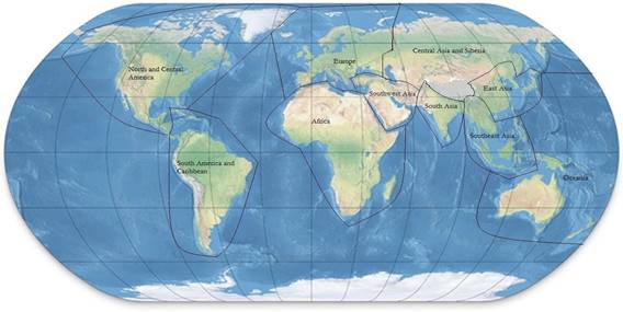
Figure 1: The ten world regions we are using for comparisons
These specified world regions are somewhat
arbitrarily bounded but we have developed this spatial set of categories based
on our knowledge of where large cities first emerged, and also with attention
to the issue of largest empires. Our data collection effort with regard to
these world regions is incomplete because most earlier studies focus on regions
that had the largest cities (see Figure 2). Thus, for example, we have very
little information about the sizes of largest settlements in Oceania before the
modern colonial era. But this is an occlusion that can be remedied with greater
effort. Archaeological evidence is sufficient for estimating the sizes of
settlements and so a survey of archaeological studies in Oceania would produce
estimates of largest settlement sizes.
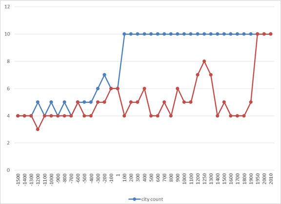
Figure 2: The Number of World
Regions for which we currently have estimates of the largest cities and empires
from 1500 BCE to 2010 CE.
Indicators of regional complexity based on estimates of the population sizes of settlements
David
Wilkinson (1992b, 1993) compared East Asia with West Asia using data from Tertius Chandler (1987) on the number of large cities in each region. Wilkinson used
political-military interaction networks (which he calls “civilizations”) as his
unit of analysis. Political-military interaction networks (PMNs) are a good
unit of analysis because the alliances and enmities of polities are an
important systemic feature of all world-systems. But PMNs change in size and
location over time. For purposes of our present study we will use constant
regions (described above) as the units of analysis. We have improved upon Wilkinson’s
(1992b,1993) studies by using the population sizes of the largest city in each
region and by using improved estimates of the sizes of cities. [12]
Using only the number of large cities, as Wilkinson’s study did, ignores important differences in the sizes of
cities.
For our study of constant regions we have made good progress on finding
estimates for the largest city and the largest polity in each world region
since 1500 BCE, but we still have many gaps in which we have not yet been able
to find the relevant estimates (See Figure 2 above). When estimates are missing
the graphs indicate (mistakenly) that the largest city has no population. All regions have largest settlements, so zero
means missing estimates of settlement size, not the absence of settlements.
Estimating the Population Sizes of
Settlements
Accurate estimation of the population sizes of
both contemporary and ancient settlements is a complicated problem. Daniel Pasciuti (Pasciuti 2003; Pasciuti and Chase-Dunn 2003) has proposed a measurement
error model for estimating the sizes of settlements based on the literature in
archaeology, demography and urban geography.[13]
We define settlements as a spatially
contiguous built-up area. This corresponds to what the United Nations methodology
calls “urban area” or “urban agglomerations” (UN 2011b). This is the best
definition for comparing the sizes of settlements across different polities and
cultures because it ignores the complicated issue of governance boundaries
(e.g. municipal districts, etc). But it still has some problems. Most cultures
have nucleated settlements in which residential areas surround a monumental,
governmental or commercial center. In such cases it is fairly easy to spatially
bound a contiguous built up area based on the declining spatial density of
human constructions. But other cultures space residences out rather than
concentrating them near a central place (e.g. many of the settlements in the preshistoric American Southwest such as Chaco Canyon). In such cases it is necessary to choose a
standard radius from the center in order to make comparisons of population
sizes over time or across cultures.
We are studying only the largest cities in each
region but it is still a lot of cities, so we must primarily rely on data
sources that offer estimates of the sizes of many cities over long periods of
time. The three main data sources we use are:
1. Tertius Chandler 1987 Four Thousand Years of Urban Growth;
2. George Modelski 2003 World Cities: –3000 to 2000; and
3. Ian Morris 2013 The Measure of Civilization
Tertius Chandler’s (1987)
compendium is still the most comprehensive study of large cities, but
substantial improvements were made in George Modelski’s
(2003) compendium. Ian Morris also provides estimates of the largest cities in
his book, discussed above, on measuring the development of Eastern and Western
civilizations (Morris 2013). From 1950 to 2010 we use the U.N. (2011a) urban
area estimates.[14]
The
comparison of world regions requires interval-level measurement, but a certain
degree of measurement error is tolerable because we are mainly looking for
large differences. After 1500 BCE there is substantial agreement in most cases about
the sizes of the largest cities. Our approach is to use these three sources of
data to choose the best estimates of the sizes of the largest cities in each
world region. When there were conflicts we usually gave priority to Morris
because his estimates used both Modelski and Chandler
as well as other sources for particular cities. When Morris did not provide an
estimate we defaulted to Modelski, and when Modelski was silent we used Chandler.[15]
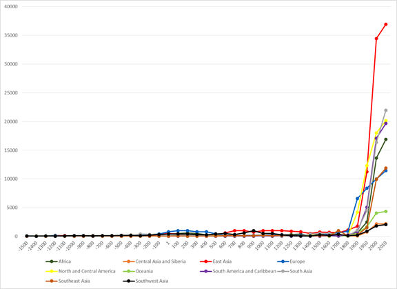
Figure 3: The population sizes of largest cities in 10 world regions, 1500 BCE to 2010 CE (thousands)
Because
the overall trend is for settlement sizes to increase and because there was an
explosion in the population sizes of cities after 1800 CE it is difficult to
see differences across the world regions before then in Figure 3. But Figure 3
clearly shows the recent increase in the sizes of the largest cities in all
world regions and the dramatically larger increase in the size of the largest
city, greater Tokyo, in East Asia.
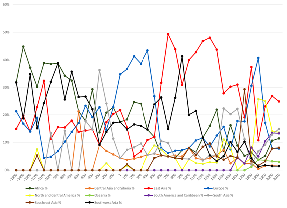
Figure 4: The relative population sizes of Largest Cities in each Region, 1500 BCE- 2010 CE as a percentage of the sum of the sizes of the cities in all the world regions for which we have estimates
Figure 4 allows us to see variation in the relative
sizes of cities across regions because the values are the percentages of the
total population of all the largest cities represented by the largest city in
each region. Recall that we are missing
a lot of estimates before 100 CE so the percentages shown would be
somewhat lower if we were able to include these. In Figure 4 we can still see the
world’s first cities in Mesopotamia and Egypt represented here by the regional
designations “Africa” and “Southwest Asia.” This emergence occurred in the
early Bronze Age with the rise of Uruk in Mesopotamia. Figure 4 (starting in 1500 BCE because of the
absolute dating problems discussed above) shows that cities in Africa (green) and
in Southwest Asia (black) remained among the largest in the world until the
late first millennium. After that Africa was not again at the top but it was
second in two later periods. Southwest Asia rebounded in medieval times because
of the great size of Abbasid Baghdad. This
is strong evidence for the existence of uneven development and the geographical
movement of the cutting edge of social complexity, but it also shows that
regions can make a comeback. South Asia (grey) had the largest city in the
world (Pataliputra, the Mauryan
capital) in 300 BCE and then returned to near the top from 1400 to 1600 CE.
The trajectories of Europe (blue) and East Asia
(red) in the world urban size distribution are very interesting. The relative
size of European cities (indicated by the blue dots) shows a long oscillation
around a middle level, indicating Europe’s peripheral and semiperipheral
location in the larger Central PMN.[16] The European trajectory in Figure 4 reflects
the rise and fall of Rome as the largest city in the world and then, around
1450 CE Europe began a rise of city sizes relative to the other regions that
peaked in 1900 CE when London was the largest world city.
East Asia (red) rose later than the African and
Southwest Asian original heartland of cities, but was second in 1100 BCE
because of the large size of Yin, the last capital of the Shang Dynasty (see
appendix). After that East Asia bounced around in middle positions and then
rose to a level higher than any other region in 700 CE (Tang Dynasty Chang’an). East Asia was back at the top again from 1100 to
1300 CE (Kaifeng and Hangzhou). In 1300 CE the largest cities in the world were
those shown in Table 1.
|
World Region |
Political/Military Network |
City Name |
City Populations (Thousands) |
|
East Asia |
East Asian PMN |
Hangzhou |
800 |
|
Africa |
Central PMN |
400 |
|
|
Europe |
Central PMN |
Paris |
228 |
|
Central Asia and Siberia |
Central PMN |
Sarai |
100 |
|
South Asia |
Central PMN |
Delhi/Gaur |
100 |
|
Southeast Asia |
Indonesian PMN |
Angkor |
90 |
|
North and Central America |
Mesoamerican PMN |
50 |
|
|
Southwest Asia |
Central PMN |
60 |
|
|
Oceania |
Missing |
||
|
South America and Caribbean |
Missing (Cuzco?) |
Table 1: Eight largest cities in world regions in 1300 CE (thousands)
Table
1 shows that the largest city on Earth in 1300 CE (Hangzhou) was in East Asia.
We should also note that Beijing, Kamakura, Guangzhou, and several other East
Asian cities were among the largest in 1300 CE.[17]
We will discuss more about the European and East Asian trajectories below.
Table 1 also shows which political/military network each city was in. We will
be comparing both the trajectories of both Europe and the Central PMN in what
follows.
New York became the
largest city in the world by 1925, beating out London (see the yellow dots in
Figure 4 for North America and the Caribbean). The relatively smaller and older
European cities (e.g. London and Paris), were surpassed by the much larger
American and Japanese cities in the 20th century.
Europe
vs the Central PMN
Figure
5 shows the relationship between the largest city in Europe and that in the
Central PMN. Europe has been part of the
Central PMN since the Bronze Ages so we should expect there to be great
similarities, and that is what Figure 5 shows. We composed the Central PMN by
combining the cities in world regions as follows: Inspired by David Wilkinson’s
chronograph we start with the combination of Southwest Asia, Africa (Egypt) and
Europe in 1500 BCE, and then add Central and South Asia in 1000 CE, the
Americas in 1500 CE, Southeast Asia in 1800 and East Asia in 1900 CE. So East
Asia became part of the Central PMN after 1850CE, but we stop comparing in 1800
CE for this reason and because the city sizes become so large that it is hard
to see earlier variation if we include the years after 1800 CE.
Figure 5: The sizes of the largest cities in Europe and in the Central PMN
The
long and deep literature on East/West comparisons is usually a bit vague as to
what exactly is being compared with what. Much of the literature is about China
vs. England or China vs. Europe. Morris (2010, 2011) is careful to include
Western Asia and Northern Africa, the original heartlands of cities and states,
in what he thinks about as “the West.” Figure 5 shows that the only great
difference between Europe and the Central PMN occurred during the rise of the
Islamic caliphates and the building of the great Abbasid capital that was
Baghdad while Europe was in a slump with regard to city sizes. The partial
correlation coefficient (controlling for year) shown in Table 2 below is .821
and is significant at the .001 level.
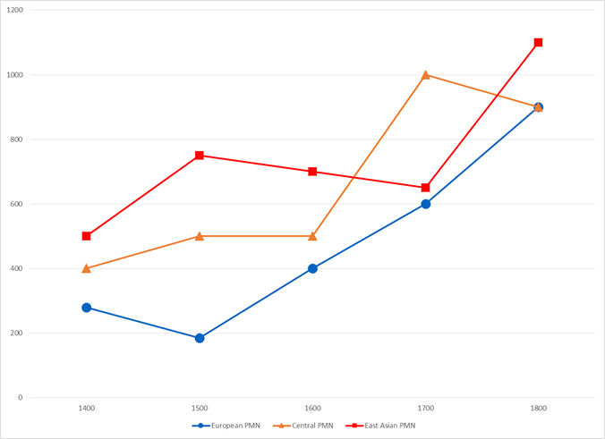
Figure 6: Population Sizes of Largest Cities in East Asia, Europe and the Central PMN, 1400 CE- 1800 CE
We also want to have a
closer look at the sizes of cities in world regions in the period between 1400
CE and 1800 CE because of the issues raised in Andre Gunder
Frank’s (1998) study of the relationship between China and the West in this
period. Recall that Frank contended that the rise of the West (what Kenneth Pomeranz (2000) has called the “Great Divergence”) occurred
later than most Eurocentric scholars have claimed. The evidence from relative sizes of cities in
Figure 5 shows an urban recovery in Europe after 1500 CE and that the largest
European city was nearly as big as the largest city in East Asia in 1700 CE. Beginning
in 1500 the largest European city, Istanbul (formerly Constantinople),[18]
began a rapid period of growth as a result of being the capital of the Ottoman
Empire. Figure 6 also shows the
trajectory for the Central PMN as well as for Europe and East Asia. Europe is a
subregion of the larger interaction network of
fighting and allying polities that includes the Americas, Africa, Southwest
Asia and South Asia in this period. The
story of the comparison between East Asia and the Central PMN is rather similar
to the comparison with Europe except that the Central PMN did not decline as
much as Europe did and it always had larger cities than did Europe even though
we include Constantinople/Istanbul as within Europe. Frank’s idea that China
declined around 1800 is supported by the city size data shown in Figure 4. European
growth experienced another upsurge after 1750 with the mushrooming of London,
but the size of London did not equal that of Beijing until 1825. Within East
Asia, Tokyo did not become larger than Beijing until 1900.
Our examination of
the largest cities in Europe and East Asia further reflects upon Frank’s (1998)
characterization of the centrality of China and the rise of European hegemony. Frank’s
idea that the European rise was sudden and conjunctural,
occurring in the 18th century, is not supported by the city size
data. Figure 4 shows that Europe (blue dots) began a recovery from the collapse
of Rome and the Western Roman empire during the late first millennium, then
suffered a relapse and experience another recovery that stared in 1250 CE that
led to a peak in 1900 with the huge size of London mentioned above. Some of
Europe’s apparent rise was due to the large size of Ottoman Istanbul, which we
categorize as in Europe because it is on the north side of the Bosphorus. Though Istanbul was within the continent of
Europe as we have defined it, the Frank Project[19] might
contend that crediting the Christian Europeans of later fame with the successes
of the Ottoman Turks is unfair, and that this does not challenge his hypothesis
of the conjunctural nature of European hegemony.
But
there are some other facts that need to be taken into account here. The second
and third largest cities in Europe in 1500 were Paris and Venice, followed by
Naples and Milan. From 1500 to 1600
Paris grew from 185,000 to 245,000 and the other large cities of Christian
Europe grew at a similar pace. So the
early upsurge was not due only to the growth of Istanbul. Christian Europe was also experiencing a
sixteenth century boom period. This does not dispute the relatively greater
centrality of China in this period, but it does suggest that Christian Europe
did not remain a peripheral backwater until it finally sprang to hegemony at
the last minute in the 18th century. Istanbul’s size leveled off in
1600 and it stayed at that size until 1700, after which it began to decline. In
this same period the largest cities of Christian Europe were growing rapidly.
London grew larger than Istanbul by 1750.
The trajectory of
Europe (displayed in Figures 4 and 5) supports part of Gunder
Frank’s (1998) analysis, but contradicts another part. The small cities of
Europe in the early period indicate its peripheral status vis a vis the core regions of West Asia/North Africa, South Asia
and East Asia. As Frank argues, Europe did not best East Asia (as indicated by
city sizes) until the eighteenth century.
But the long stepped European rise contradicts Frank’s depiction of a
sudden and conjunctural emergence of European
hegemony. Based on relative city sizes
it appears that the rise of Europe occurred in waves beginning with the
recovery from the fall of Rome.
For East Asia we see
in Figure 4 and Table 1, a high peak in 1300 CE. Then there was a decline and another peak in
1700. Not until 1825 was East Asia bested by the European cities after a
decline that started in 1800 and continued until 1900, when an Asian recovery
began. The European cities were bested again by the East Asian cities between
1950 and 1970 during the rapid decline of the European cities in terms of their
size-importance among the world’s largest cities. This most recent rise of the
East Asian cities is a consequence of the upward mobility of Japan and China in
the global political economy. Smith and
Timberlake (2001) have demonstrated the contemporary rising importance of East
Asian cities in the global airline transportation network. Greater Tokyo, the
third largest city in 1925, had become the largest city on Earth by 1970, and
Osaka held third place in that year. By 1980 Tokyo was still first, but Mexico
City held second place, and Sao Paolo was in fourth place.
Frank’s depiction of a sudden and radical decline of China
that began in 1800 CE is supported in Figure 6.
His analysis in Reorient (Frank 1998) focused on the
period from 1400 to 1800 CE, but did not examine the relative decline of East
Asian urban predominance that began in 1350 nor the rise to a new peak that
began in 1700 as indicated in Figure 6.
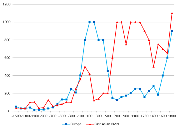
Figure 7: East Asian and European largest cities, 1500 BCE to CE 1800
Figure 7 shows more
clearly the relationships between the rise and fall of largest cities in Europe
and East Asia. Morris (2010) describes a see-sawing relationship between East
Asia and the West. But we also want to compare East Asia with Europe alone
because much of the long and deep literature about relative development has
focused on alleged differences between European and East Asian societies and
cultures. It has also been asserted by
Frank and other sinocentrists that China led in the
development of complexity and hierarchy in the multicore Afroeurasian
system. We will try to evaluate these
hypothesis with our city size data on world regions. In Figure 7 the comparison
of East Asia with Europe shows that East Asia had a head-start compared with
Europe. After that they both rise but the Greco-Roman cities were much larger
than cities in East Asia and they lasted longer than the Han cities did. So the
city size trajectories show an East Asian divergence during the time of the Han
and Roman Empires, with Han cities declining earlier. After that there is a
long period in which European and East Asian cities are indeed
counter-cyclical, but this again changes into synchrony after 1500 CE.
The partial Pearson’s r correlation coefficients
among East Asia, Europe and the Central PMN are shown in Table 2.
|
Region
or PMN |
Europe |
Central
PMN |
East
Asian |
|
Europe |
1 |
.828
sig.= .000 |
-.381
sig.= .026 |
|
Central
PMN |
.818
sig.= .000 |
1 |
-.170
sig.= .335 |
|
East
Asian Region and PMN |
-.381
sig.= .026 |
-.170
sig.= .335 |
1 |
Table 2: Pearsons r partial correlation coefficients (controlling for Year) for population sizes of the largest cities in East Asia, Europe and the Central PMN from 1500 BCE to 1800 CE (n= 35)
Though
the temporal relationship between East-West largest city sizes obviously has
periods of convergence that can be seen in Figure 7 and 8, the overall
relationship is slightly negative, and it is somewhat smaller for the East
Asia/Central PMN comparison than for the East Asia/Europe comparison. These
coefficients control for the long-run trend toward greater city sizes by using
Year as a control variable. The negative
East/West coefficients are not statistically significant and are only weak
support for the see-saw hypothesis.
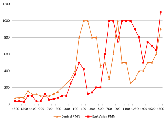
Figure 8: Largest cities in East Asia and the Central PMN
But
if we compare East Asia with the Central PMN as in Figure 8 we see that the
Central PMN was right up there with East Asia in the period following 1500 CE.
And indeed we know that cities and states emerged earlier in Southwest Asia and
in Egypt than they did in China. The story in Figure 8 is mostly similar with
the Europe/East Asia comparison in Figure 7, except that the Central PMN as a
whole did recover from the decline of Rome in the form of the rise of Islam. So
the first great divergence is less divergent if we consider the whole
European/West Asian/North African context.
Walter Scheidel
contends that the sequence of empire rise and fall in East Asia was different
from that in the West, a situation he refers to as “first great divergence”
taking a que from Kenneth Pomeranz’s analysis of the
much later great divergence. In East Asia the decline of the Han cities was
soon followed by the rise of new large cities, whereas in the West the decline
of Rome was followed by a rather long and deep period in which cities did not
soon regain the great size of Rome.[20] Regarding
Scheidel’s idea, the city data shown in Figure 6 indicates
that Han Chang’an declined earlier than did Rome, and
this should be taken into account in comparing the length of city size
declines. When this is done the length of Eastern and Western decline periods
appear rather similar.
Conclusions
Our results suggest problems with Andre Gunder Frank’s (1998) characterization of the relationship
between Europe and China before and during the rise of European hegemony.
Frank’s contention that Europe was primarily a peripheral region relative to
the core regions of the Afro-eurasian world-system is
mainly supported by the city data, with some qualifications. Europe was for millennia a periphery of the
large cities and powerful empires of ancient West Asian and North Africa. The
Greek and Roman cores were instances of semiperipheral marcher states that
conquered important parts of the older West Asian/North African core. After the
decline of the Western Roman Empire, the core shifted back toward the East and
Europe was once again importantly peripheral (or semiperipheral).
The
partial support for Morris’s idea of see-sawing challenges the idea proposed in
Frank and Gills (1994) that there was an integrated and synchronized Eurasian
world-system around 500 BCE. Victor Lieberman’s (2002, 2011) more nuanced
approach to the issue of synchrony, which distinguishes between regions that
were exposed to Central Asian nomad incursions from those that were not, may yet vindicate some of what the Frankians have contended. We cannot yet be certain that
interaction networks were important early causes of either synchrony or
see-sawing, and if they were, we do not know which kind of interaction was most
important.
Counter
to Frank’s contention, however, the rise of European hegemony was not a sudden conjunctural event that was due solely to a developmental
crisis in China and European luck in conquering the Americas. The city
population data indicate that an important renewed core formation process had
been emerging in waves within Europe since not long after the fall the Western
Roman Empire, with a strong and steady upsurge since the 15th
century. This was partly a consequence
of European extraction of resources from its own expanded periphery. But it was
also likely due to the unusually virulent form of capitalist accumulation
within Europe, and the effects of this on the nature and actions of states. The
development of European capitalism began among the city-states of Italy. It
spread to the European interstate system, eventually resulting in the first
capitalist nation-state – the Dutch Republic of the seventeenth century as well
as the later rise of the hegemony of the United Kingdom of Great Britain in the
nineteenth century. This process of regional core formation resulted in a
greater emphasis on capitalist commodity production than occurred in the also
commercializing other world regions. And European states increasingly allowed
finance capital to play a powerful role in policy formulations (Braudel 1984; Arrighi 1994). This
further spread and institutionalized the logic of capitalist accumulation which
altered the balance of power within Europe by defeating the efforts of
territorial empires (the Hapsburg Empire, Napoleonic France, National Socialist
Germany) to return the expanding European core to a more tributary mode of
accumulation.
Acknowledging
some of the unique aspects of the emerging European hegemony does not require
us to ignore the important continuities that also existed as well as the
consequential ways in which European developments were linked with processes
going on in the rest of the Afroeurasian
world-system. Frank’s (1998; 2014) insistence that the whole system and its
interconnections must be studied in order understand uneven development is
still yet rarely seen in the social science history literature. And much of the
literature on European exceptionalism represents valid criticisms. But the West
did rise, despite Frank’s efforts to show that it was later and more conjunctural than many thought. So the great divide remains
an important problem for social science.
The
more recent emergence of East Asian cities as again the very largest settlements
on Earth occurred in a context that was structurally and developmentally
distinct from the multi-core system that still existed in 1800 CE. Since 1850
CE there has only been one core because all core states are directly
interacting with one another in the now-global interstate system. While the
multi-core system prior to the nineteenth century was undoubtedly integrated to
an important extent by trade, it was not as interdependent as the global
world-system has now become.
A new East Asian
hegemony is by no means a certainty, as both the United States and German-led
Europe will continue to be strong contenders in the coming period of hegemonic rivalry and multipolar global
governance (Bornschier and Chase-Dunn 1999). In this
competition megacities may be more of a liability than an advantage because the
costs of these huge human agglomerations have continued to increase, while the
benefits have been somewhat diminished by the falling costs of transportation
and communication. Nevertheless
megacities will continue to be a useful indicator of predominance because
societies that can afford them will have demonstrated the ability to mobilize
huge resources.
References
Abu-Lughod, Janet Lippman 1989. Before
European Hegemony The World System A.D. 1250-1350
New
York: Oxford University Press.
Adams,
Robert McCormick 1981 The Heartland of
Cities: Surveys of Ancient Settlement and Land
Use on the Central Floodplain of the Euphrates. Chicago: University
of Chicago Press
Álvarez, Alexis. E.N. Anderson, Elisse
Basmajian, Hiroko Inoue, Christian Jaworski, Alina
Khan, Kirk Lawrence, Andrew Owen,
Anthony Roberts, Panu Suppatkul
and
Christopher Chase-Dunn 2013 Comparing World-Systems: Empire Upsweeps
and
Non-core marcher states Since the
Bronze Age” Presented at the annual meeting of
the
American Sociological Association, New York, August
Amin, Samir 1980. Class
and Nation, Historically and in the Current Crisis. New York: Monthly
Review Press.
Anderson, E. N. and Christopher Chase-Dunn “The
Rise and Fall of Great Powers” in
Christopher Chase-Dunn and E.N.
Anderson (eds.) 2005. The Historical
Evolution of World-Systems.
London: Palgrave.
Arrighi,
Giovanni 1994. The
Long Twentieth Century. London: Verso.
______________
2008 Adam Smith in Beijing. London:
Verso.
Arrighi, Giovanni, Takeshi Hamashita, and Mark Selden
2003 The Resurgence of East Asia :
500, 150 and 50 Year
Perspectives. London: Routledge
Bairoch,
Paul 1988 Cities and Economic Development
Chicago: University of Chicago Press.
Barfield, Thomas J. 1989 The Perilous Frontier: Nomadic Empires and China. Cambridge, MA.:
Blackwell
Beaujard, Philippe. 2005 “The Indian Ocean in Eurasian and African
World-Systems Before
the
Sixteenth Century” Journal of World History 16,4:411-465.
_______________ 2012a Les mondes de l’océan
Indien Tome I: De la formation de l’État
au
premier système-monde
Afro-Eurasien (4e millénaire
av. J.-C. – 6e siècle apr. J.-C.).
Paris: Armand Colin.
_______________2010. “From
Three possible Iron-Age World-Systems to a Single Afro-
Eurasian
World-System.” Journal of World History
21:1(March):1-43.
_______________ 2112b Les mondes
de l’océan Indien Tome II: L’océan Indien, au coeur des
globalisations
de l’ancien Monde du 7e au 15e siècle. Paris: Armand
Colin
Beckwith,
I. Christopher. 1991. "The Impact of the Horse and Silk Trade on the
Economies
of T'ang China and
the Uighur Empire." Journal of the
Economic and Social History of the
Orient 34:2:183-198.
Bentley, Jerry H.
1993. Old World Encounters: Cross-Cultural Contacts and Exchanges in
Pre-
Modern Times. Oxford:
Oxford University Press.
Blanton, Richard E. , Stephen A. Kowalewski, and Gary Feinman. 1992.
"The Mesoamerican World-System."
Review 15:3(Summer):418-426.
Bosworth, Andrew 1995 "World cities and
world economic cycles" Pp. 206-228 in Stephen
Sanderson (ed. ) Civilizations and World Systems. Walnut Creek,CA.: Altamira.
Braudel, Fernand 1972 The
Mediterranean and the Mediterranean World in the Age of Philip II.
New
York: Harper and Row, 2 vol.
_____________. 1984. The Perspective of the World, Volume 3
of Civilization and Capitalism.
Berkeley: University of California Press
Chandler, Tertius
1987 Four Thousand Years of Urban Growth:
An Historical Census.
Lewiston,
N.Y.: Edwin Mellon Press
Chase-Dunn, Christopher 1985 "The system
of world cities: A.D. 800-1975." Pp. 269-292 in
Michael
Timberlake (ed.) Urbanization in the
World-Economy, New York: Academic
Press.
Chase-Dunn,
C. 1988. "Comparing world-systems:
Toward a theory of semiperipheral
development," Comparative
Civilizations Review, 19:29-66, Fall.
Chase-Dunn,
C. 2015 “Periodizing
the Thought of Andre Gunder Frank: From
Underdevelopment to the
19th
Century Asian Age” Journal of World-System Research 21, 1.
http://www.jwsr.org/wp-content/uploads/2015/03/ChaseDunn_vol21_no1.pdf
Chase-Dunn,
C and Thomas D. Hall 1993"Comparing World-Systems: Concepts and
Working Hypotheses" Social Forces 71:4(June):851-886.
____________________________1997 Rise and Demise: Comparing World-Systems
Boulder,
CO.: Westview Press.
Chase-Dunn, Christopher and Thomas D. Hall. 2011“East and West in world-systems
evolution” Pp. 97-119 in Patrick Manning and Barry K. Gills (eds.) Andre Gunder Frank and Global Development, London: Routledge.
Chase-Dunn, Christopher, Thomas D. Hall, & Peter Turchin. 2007 “World-Systems in the Biogeosphere: Urbanization, State Formation, and Climate Change Since the Iron Age.” Pp.132-148 in The World System and the Earth System: Global Socioenvironmental Change and Sustainability Since the Neolithic, edited by Alf Hornborg and Carole L.
Crumley. Walnut Creek, CA: Left Coast Books.
Chase-Dunn,
C. and Susan Manning, 2002 "City systems and
world-systems: four millennia of city growth and decline,"
Cross-Cultural
Research
36, 4: 379-398 (November
Chase-Dunn, C. , Susan Manning and Thomas D.
Hall 2000 “Rise and fall: East-West
synchronicity
and Indic exceptionalism reexamined,” Social
Science History. 24,4:727-
754.
Chase-Dunn
C. and Alice Willard 1994 "Cities in the Central Political-Military
Network
Since CE 1200" Comparative
Civilizations Review, 30:104-32 (Spring).
Chase-Dunn, C. and Andrew K. Jorgenson 2003 “Regions and Interaction Networks: an
institutional
materialist perspective,” International Journal of Comparative Sociology
44,1:433-450.
Chase-Dunn,
C. Eugene N. Anderson, Hiroko Inoue,
Alexis Álvarez, Lulin Bao,
Rebecca Álvarez,
Alina Khan and Christian Jaworski 2013 Semiperipheral Capitalist
City-States and the
Commodification of Wealth, Land, and Labor Since the Bronze Age IROWS Working Paper #79 available
at https://irows.ucr.edu/papers/irows79/irows79.htm
Chase-Dunn,
C and Bruce Lerro 2014 Social Change: Globalization from the Stone Age to the
Present. Boulder, CO: Paradigm
Chase-Dunn,C. David Wilkinson, E.N. Anderson, Hiroko Inoue and Robert Denemark
Time Mapping
Globalization since the Bronze Age IROWS Working Paper # 100.
Chew,
Sing C. 2001 World ecological degradation : accumulation, urbanization, and
deforestation, 3000
B.C.-A.D. Walnut Creek, CA: Altamira Press
___________ 2007 The Recurring Dark Ages : ecological stress,
climate changes, and system
transformation Walnut Creek, CA: Altamira Press
Ekholm, Kasja
and Jonathan Friedman 1982 “’Capital’ imperialism and exploitation in the
ancient world-systems” Review 6:1 (summer): 87-110.
Elvin,
Mark. 1973. The Pattern of the Chinese
Past. Stanford: Stanford University Press.
Fitzpatrick,
John. 1992. "The Middle Kingdom, the Middle Sea, and the Geographical
Pivot
of History." Review XV, 3 (Summer): 477-521
Fletcher,
Roland 1995 The Limits of Settlement
Growth. Cambridge: Cambridge
University Press.
______ n.d. City and
Polity Data Files, Personal communication
Flynn, Dennis O. 1996 World Silver and Monetary History in the 16th and 17th
Centuries.
Brookfield,
VT: Variorum.
Frank, A. G., B.K. Gills, B. K. 1993. The Cumulation of Accumulation. Pp.
81-114 in A.G.
Frank
and B.K. Gills, (eds.) The World System:
Five Hundred Years or Five Thousand?
London:
Routledge.
Frank, Andre Gunder
1998 Reorient: Global Economy in the
Asian Age. Berkeley: University of
California
Press.
_________________ 2014 Reorienting the 19th Century: Global Economy in the
Continuing Asian
Age.
Boulder, CO: Paradigm Publishers.
Frank, Andre Gunder
and Barry Gills 1994 The World System:
500 or 5000 Years? London:
Routledge.
GeaCron World History Atlas & Timelines since 3000 BC . Luis Músquiz
http://geacron.com
Hall, Thomas D., Christopher Chase-Dunn and Richard Niemeyer. 2009 “The Roles of Central Asian Middlemen and Marcher States in Afro-Eurasian World-System Synchrony.” Pp. 69-82 in The Rise of Asia and the Transformation of the World-System,
Political Economy of the World-System Annuals. Vol XXX, edited by Ganesh K. Trinchur. Boulder, CO: Paradigm Press.
Honeychurch, William 2013 “The Nomad as State Builder: Historical Theory
and Material
Evidence from Mongolia” Journal of World Prehistory 26:283–321
Hui, Victoria Tin-Bor 2005 War and state Formation in Ancient China and Early Modern Europe. Cambridge: Cambridge University Press._________________ 2008 “How China was ruled” China Futures, Spring, 53-65Innis, Harold 1972 [1950] Empire and Communications. Toronto: University of Toronto Press.
Inoue, Hiroko 2014
“Settlement dynamics and empire dynamics: a comparative and
evolutionary world-systems perspective” Paper
presented at the annual meeting of
the American Sociological Association, San Francisco,
August 17.
Inoue,
Hiroko, Alexis Álvarez,
Kirk Lawrence, Anthony Roberts, Eugene N Anderson and
Christopher
Chase-Dunn 2012 “Polity scale shifts in world-systems since the Bronze Age:
A comparative inventory
of upsweeps and collapses” International
Journal of Comparative Sociology
http://cos.sagepub.com/content/53/3/210.full.pdf+html
Inoue, Hiroko, Alexis Álvarez, Eugene N. Anderson, Andrew Owen, Rebecca Álvarez, Kirk
Lawrence and Christopher Chase-Dunn 2015 “Urban scale shifts since the Bronze
Age: upsweeps, collapses and semiperipheral development” Social Science History Volume 39 number 2, Summer
Kowalewski, Stephen A.
1982 "The evolution of primate regional systems" Comparative Urban
Research
9,1:60-78.
Lattimore, Owen 1940 Inner Asian Frontiers of China. New York: American Geographical
Society.
Lassner,
Jacob 1970 The Topography of Baghdad Detroit: Wayne State University Press.
Lenski,
Gerhard 2005 Ecological-Evolutionary Theory. Boulder, CO: Paradigm
Publishers
Lieberman, Victor. 2003. Strange Parallels: Southeast Asia in Global Context, c. 800-1830. Vol.
1:
Integration on the Mainland.
Cambridge: Cambridge University
Press.
______________ 2009. Strange
Parallels: Southeast Asia in Global
Context, c. 800-1830. Vol 2:
Mainland
Mirrors: Europe, Japan, China, South Asia, and the Islands. Cambridge:
Cambridge
University Press.
Liu,
Xinru and Lynda Norene Shaffer.
2007. Connections across Eurasia:
Transportation,
Communication, and Cultural Exchange on the Silk Roads. New York:
McGraw-Hill.
Mann,
Michael. 1986. The Sources of Social Power, Volume 1:
A history of power from the beginning
to A.D. 1760. Cambridge: Cambridge University Press.
McNeill, W H. 1982. The Pursuit of Power: Technology, Armed
Force, and Society since A.D. 1000.
Chicago,
IL: The University of Chicago Press.
McNeill,
John R. and William H. McNeill 2003 The Human Web. New York: Norton.
Modelski, George 2003 World
Cities: –3000 to 2000. Washington, DC:
Faros 2000
______________ Tessaleno
Devezas and William R. Thompson (eds.) 2008 Globalization
as
Evolutionary
Process: Modeling Global Change.
London: Routledge
Morris, Ian 2010 Why the West Rules—For Now.
New York: Farrer, Straus and
Giroux
______ 2013 The
Measure of Civilization. Princeton, NJ: Princeton University Press.
_______ and Walter Scheidel
(eds.) The Dynamics of Ancient Empires:
State Power from Assyria to
Byzantium. New York: Oxford
University Press.
Neal, Teresa 2013 “The Sasanian empire and world-systems Research” Working Paper,
Department of History, University of
California-Irvine
Pasciuti , Daniel 2002” A
measurement error model for Estimating the Population
Sizes of Preindustrial Cities”
Pasciuti,
Daniel and Christopher Chase-Dunn 2002 “Estimating the Population Sizes of
Cities”
https://irows.ucr.edu/research/citemp/estcit/estcit.htm
Pomeranz, Kenneth 2000 The Great Divergence: Europe,
China and the Making of the Modern World
Economy. Princeton: Princeton University Press.
Rozman, Gilbert 1973 Urban Networks in Ching
China and Tokogawa Japan. Princeton, NJ:
Princeton
University Press.
Sanders,
William T., Jeffrey R. Parsons, and Robert S. Santley
1979 The Basin of Mexico:
Ecological Processes in the Evolution of a Civilization. New York: Academic
Press,
Scheidel, Walter
2009 “From the “great convergence” to the “first great divergence”:
Roman and Qin-Han state formation”
Pp. 11-23 in Walter Scheidel (ed.) Rome and
China: Comparative Perspectives on
Ancient World Empires.
New York: Oxford University
Press.
____________
and Sitta Von Reden (eds.) The Ancient Economy. New York:
Routledge.
SESHAT: The
Global History Data Bank. The Evolution Institute http://evolution-institute.org/seshat
Sherratt, Andrew G. 1993a. "What Would a Bronze-Age World
System Look Like? Relations Between
Temperate Europe and
the Mediterranean in Later Prehistory."
Journal of European Archaeology
1:2:1-57.
_____. 1993b.
"Core, Periphery and Margin:
Perspectives on the Bronze Age."
Pp. 335-345 in
Development and Decline in the Mediterranean Bronze Age, edited by C. Mathers and S. Stoddart. Sheffield:
Sheffield Academic Press.
_____. 1993c. "Who are You Calling
Peripheral? Dependence and Independence
in European Prehistory."
Pp.
245-255 in Trade and Exchange in
Prehistoric Europe, edited by C. Scarre and F.
Healy. Oxford:
Oxbow (Prehistoric
Society Monograph).
_____. 1993d. "The Growth of the Mediterranean
Economy in the Early First Millennium BC."
World Archaeology 24:3:361-78.
Schwartzberg, Joseph E. 1992 A Historical Atlas of South Asia New
York: Oxford
University Press. eMap :
Atlas : Document : English : 2nd impression. Chicago, Ill. :
Digital South Asia
Library, Center for Research Libraries
http://dsal.uchicago.edu/reference/schwartzberg/
Taagepera, Rein 1978a
"Size and duration of empires: systematics of size" Social Science
Research 7:108-27.
______
1978b "Size and duration of empires: growth-decline curves, 3000 to 600
B.C."
Social Science Research, 7
:180-96.
______1979
"Size and duration of empires: growth-decline curves, 600 B.C. to 600
A.D."
Social Science History
3,3-4:115-38.
_______1997
“Expansion and contraction patterns of large polities: context for Russia.”
International Studies Quarterly 41,3:475-504.
Teggart,
Frederick J. 1939 Rome and China: A Study
of Correlations in Historical Events Berkeley:
University of California Press.
Tilly,
Charles. 1990. Coercion,
Capital, and European States, AD 990-1990. Cambridge, MA:
Basil Blackwell
Turchin,Peter 2011 . Strange Parallels: Patterns in Eurasian
Social Evolution . Journal
of World Systems Research 17(2):538-552
Turchin, Peter, Jonathan M. Adams, and Thomas D. 2006.
“East-West Orientation of
Historical Empires and Modern States.” Journal of World-Systems Research. 12:2(December):218-229.
___________
and Sergey Gavrilets 2009 “The evolution of complex
hierarchical societies”
Social Evolution & History,
Vol. 8 No. 2, September: 167–198.
______________, Thomas E.Currie, Edward A.L. Turner and Sergey Gavrilets 2013
“War, space, and the evolution of Old
World complex societies”
PNAS
October vol.
110 no. 41: 16384–16389
Appendix: http://www.pnas.org/content/suppl/2013/09/20/1308825110.DCSupplemental/sapp.pdf
United Nations 2011a Data on Cities and Urban Agglomerations
http://esa.un.org/unpd/wup/CD-ROM/
United Nations 2011b World Urbanization Prospects: The 2011 Revision:
Methodology http://esa.un.org/unpd/wup/pdf/WUP2011_Methodology.pdf
United Nations: Department of Economic and
Social Affairs, “Annual Population of Urban
Agglomerations with 300,000 in habitants or
more” http://esa.un.org/unpd/wup/DataQuery/
Wallerstein, Immanuel 2011 [1974] The Modern World-System, Volume 1.
Berkeley: University of California
Press.
Walters, Pamela Barnhouse
1985 "Systems of cities and urban primacy: problems of
definition and
measurement." Pp.63-86 in Michael Timberlake (ed.) Urbanization in
the
World-Economy, New York: Academic Press.
Wilkinson, David 1987 "Central
Civilization." Comparative
Civilizations Review 17:31-59.
______________1991 "Core, peripheries and
civilizations." Pp. 113-166 in Christopher
Chase-Dunn
and Thomas D. Hall (eds.) Core/Periphery
Relations in Precapitalist Worlds,
Boulder,
CO.: Westview.
_______________1992a "Decline phases in
civilizations, regions and oikumenes." A paper presented
at the annual meetings of the International
Studies Association, Atlanta, GA. April 1-4.
______________ 1992b "Cities,
civilizations and oikumenes:I." Comparative Civilizations Review
27:51-87 (Fall).
_______________ 1993 “Cities, civilizations and
oikumenes:II”
Comparative Civilizations Review 28: 41-72.
_______________2004 The Power Configuration Sequence of the
Central World System, 1500-700 BC
Journal of World-Systems
Research Vol. 10, 3.
Wilkinson, Toby C., Susan Sherratt and John
Bennet 2011 Interweaving Worlds: Systemic
Interactions in Eurasia,
7th to 1st
Millennia BC. Oxford: Oxbow Books.
Wikipedia http://en.wikipedia.org
Wohlforth, William
C., Richard Little, Stuart J. Kaufman, David Kang, Charles A Jones,
Victoria Tin-Bor Hui, Arther Eckstein, Daniel Deudney and William L Brenner 2007
“Testing balance of
power theory in world history” European
Journal of
International Relations 13,2:
155-185.
Wolf , Eric
1997 Europe and the People Without
History, Berkeley: University of
California
Press.
Wong,
R. Bin 1997 China Transformed: Historical
Change and the Limits of European Experience.
Ithaca: Cornell University Press.