The role of ecosettlement systems in human social evolution
Christopher Chase- Dunn
Institute for Research on World-Systems
(IROWS)
University of
California, Riverside
 Abstract:
This essay examines the evolution of human institutions by focusing on the ways
that people have arranged themselves in space and the uses that they have made
of the natural and built environment. Ecosettlement systems are the patterned
ways in which humans distribute themselves across the land, the ways in which
the inhabitants of settlements interact with people in other settlements and
their interactions with nature. Not only have ecosettlement systems evolved
along with the rise of social complexity and hierarchy, but they have also played
a generative role in human social evolution at several crucial junctures. This
paper examines the settlement systems of paleolithic and archaic nomads, the
emergence of sedentism, and the co-evolution of sedentary and nomadic peoples.
Also considered are the emergence of settlement size hierarchies and the
relationship between these and socio-political hierarchies, the emergence and
spread of large cities, as well as the patterns of city growth and decline, the
emergence of city-states that specialized in trade, the expansion of market
exchange and the rise of tributary empires with their capital cities. Also
discussed are the emergence of world cities and global cities, and the
phenomenon of urbanized regions and megacities in the contemporary global settlement
system.
Abstract:
This essay examines the evolution of human institutions by focusing on the ways
that people have arranged themselves in space and the uses that they have made
of the natural and built environment. Ecosettlement systems are the patterned
ways in which humans distribute themselves across the land, the ways in which
the inhabitants of settlements interact with people in other settlements and
their interactions with nature. Not only have ecosettlement systems evolved
along with the rise of social complexity and hierarchy, but they have also played
a generative role in human social evolution at several crucial junctures. This
paper examines the settlement systems of paleolithic and archaic nomads, the
emergence of sedentism, and the co-evolution of sedentary and nomadic peoples.
Also considered are the emergence of settlement size hierarchies and the
relationship between these and socio-political hierarchies, the emergence and
spread of large cities, as well as the patterns of city growth and decline, the
emergence of city-states that specialized in trade, the expansion of market
exchange and the rise of tributary empires with their capital cities. Also
discussed are the emergence of world cities and global cities, and the
phenomenon of urbanized regions and megacities in the contemporary global settlement
system.
A paper to be presented at the session on “A compound vision: world history seen through many lenses” (organized by David Wilkinson) at the annual meeting of the International Studies Association, Honolulu, Hawaii, Friday, March 4, 10:30am-12:15. Draft v. 3-29-05. (13596 words) The IROWS Empire/City project home page is at https://irows.ucr.edu/research/citemp/citemp.html This paper is available at
https://irows.ucr.edu/papers/irows15/irows15.htm
Ecosettlement
Systems
Human settlement systems are usually understood to include the systemic (regularized) ways in which settlements (hamlets, villages, towns, cities) are linked with one another by trade and other kinds of human interaction. This essay will indeed study settlement systems understood in this way, but it will expand the notion of settlement systems to include interactions with the environment, and all the patterned ways in which humans use the landscape of the Earth. This allows us to consider the settlement systems of nomads, who often moved across the land in patterned annual cycles, and to examine the “metabolism of settlements” – the flows of energy, water, air, food, and raw materials by which human settlements have been linked with the biosphere and the geosphere. So the notion of settlement systems proposed here includes all the patterned ways in which humans interact with the landscape and with the biosphere and the atmosphere – ecosettlement systems.
It will not be presumed that settlement systems are contained within separate societies. On the contrary, it is usually impossible to understand the systemic patterns of interaction and the division of labor among settlements without looking at settlement systems within whole world-systems – systems of societies. So the unit of analysis in this essay will be world-systems. The relationship between settlements and polities is a fundamental aspect of all social systems. The territorial boundaries of polities are rarely coterminous with the interaction networks in which settlements are embedded, and so settlement systems must be studied “internationally” in all social systems. This lens is used to examine the evolution of human institutions since the time of the paleolithic big game hunters. This is a window on world history and prehistory that allows us to see the big patterns and to discern the systemic logics by which we have evolved from living in nomadic hunter-gatherer bands to living in globalized megacity regions.
Settlements are rarely ever intelligible without knowing their relations with the rural and nomadic populations that interact with them. Archaeologists and ethnographers map out the ways in which human habitations are spread across space, and this is a fundamental window on the lives of the people in all social systems. The spatial aspect of population density is perhaps the most fundamental variable for understanding the constraints and possibilities of human social organization.
Theories of
Social Change
One
could simply describe the ways in which settlement systems have changed along
with the structure of social systems using the tools that urban geographers and
anthropologists have devised – settlement size hierarchies, the spatial
structure of settlements, etc. Indeed, this is an important task in its own
right, and we are far from having accurate and complete data for knowing the
timing, growth rates and population sizes of settlements. But there are also
important theoretical issues at stake in the explanation of the observed
patterns of social change. Are ecosettlement systems only passive outcomes of
social change that are mainly determined by other factors, or are ecosettlement
systems themselves sources of generative processes that cause the emergence of
complexity and hierarchy? What has been the role of settlements with regard to
changes in the basic logic of social reproduction? This essay will examine how
the role of settlements has changed depending on the nature of the
world-systems in which they are embedded.
Some
theories of innovation claim that the discovery and implementation of new
cultural, organizational and productive technologies are systematically related
to settlement systems and their interaction networks. The recent influential
book by world historians John R. McNeill and William H. McNeill (2003), The
Human Web, employs what can be called a cybernetic perspective to
explain innovation – new stuff emerges at important nodes in communications and
transportation networks. This is a perspective that was also developed by Amos
Hawley (1971), who contended that innovation occurred at major communications
network nodes (in cities) where different kinds of information crossed paths,
enabling the recombination of elements to produce new ideas and institutions.
David Christian’s (2004) excellent Maps of Time employs a similar notion
of hubs that are the loci of innovations.
A
somewhat different explanation that is also tightly connected to settlement
systems is the notion of semiperipheral development proposed by
Chase-Dunn and Hall (1997) as a key component of their theory of world-systems
evolution. One problem with the cybernetic approach is that it does not explain
uneven development, the movement of the cutting edge of innovation. Why does
not the initial hub remain remain the center forever? What causes old hubs to
decline and new hubs to emerge?
Semiperipheral
development is the idea that
that it has mainly been semiperipheral societies that have expanded networks,
made larger states, and innovated and implemented new techniques of power and
new productive technologies that have transformed the very logic of social
change. Semiperipheral societies are those that are out on the edge of the
older core polities in an interpolity system – a system of allying and fighting
polities.[1]
The hypothesis of semiperipheral
development asserts that semiperipheral regions in core-periphery
hierarchies are fertile sites for innovation and the implementation of new
institutions that sometimes allow societies in these regions to be upwardly
mobile and/or to transform the scale (and sometimes the qualitative nature) of
institutional structures. [2]
This is not simply the notion that core traits diffuse toward the periphery. It
is rather the idea that semiperipheral innovation enables upward mobility and
occasionally transforms whole systems. Semiperipheral actors have taken
different forms in different systems. Semiperipheral marcher chiefdoms and
semiperipheral marcher states conquered older core polities to form new larger
core-wide polities. Semiperipheral capitalist city-states exploited
opportunities to accumulate wealth from trade and the production of
commodities. And in the modern world-system it is semiperipheral nation states
that have risen to become hegemonic.
The hypothesis of semiperipheral development presumes a cross-cultural conceptualization of core/periphery hierarchies in which more powerful societies importantly interact with less powerful ones. The idea of core/periphery hierarchy was originally developed to describe and account for the stratified relations of power and dependency among societies in the modern world-system. The comparative world-systems approach developed by Chase-Dunn and Hall (1997) distinguishes between core/periphery differentiation, in which there is important interaction among societies that have different degrees of population density, and core/periphery hierarchy in which some societies are dominating and/or exploiting other societies. It is not assumed that all world-systems have core/periphery relations. Rather this is a research question to be determined in each case.
Settlement
Systems of Nomads
Big game hunting is not a natural pursuit. But it is fun,
dangerous and rewarding as long as there are large edible animals that can be
killed and eaten. McNeill and McNeill (2003) describe humans as the “weed
species” because our use of symbols and tools has allowed us to specialize in
adaptability. We can move into new niches and can adjust to environmental
changes more rapidly than any other megafauna (even coyotes!). If there are big
edible animals to be hunted, even people who know how to fish and farm will
cease these activities until the large and roastable beasts have been depleted
(or extinguished) (Kirsch 1984) (see Figure 1). Big game hunters moved rapidly
into territories that were rich in large huntible and tasty animals. In two
known instances (Australia about 40,000 years ago, and the New World about
12,000 years ago) the arrival of the hunters was followed within two thousand
years by the extinction of many species of megafauna. It is hard to believe
that these extinctions were completely caused by human hunting, but that was
undoubtedly part of the story.
 The
arrival and spread of “paleoindians” in North America is signaled by a
distinctive “Clovis-style” lithic projectile point, a 5-cm. spear point with a
fluted face that was used at the end of a long spear to kill large animals such
as mastadons and elk. This distinctive projectile point is found all over North
America, and it is believed that the paleoindians followed herds in very large
and rather regular annual migration circuits. The migrating bands would come
together annually in a place with sufficient food stocks to allow for a big
gathering, and often adjacent to quarries
The
arrival and spread of “paleoindians” in North America is signaled by a
distinctive “Clovis-style” lithic projectile point, a 5-cm. spear point with a
fluted face that was used at the end of a long spear to kill large animals such
as mastadons and elk. This distinctive projectile point is found all over North
America, and it is believed that the paleoindians followed herds in very large
and rather regular annual migration circuits. The migrating bands would come
together annually in a place with sufficient food stocks to allow for a big
gathering, and often adjacent to quarries
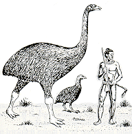
Figure 1:
Polynesians in New Zealand hunt flightless moa to extinction (Kirch 1984)
where the kinds of stone
used to make Clovis points were procured (see Figure 2). The broadly similar
nature of the projectile point style indicates a “cultural” similarity that is
continental in size (Kowalewski 1996), and this is in contrast to what happened
next in the archaeological record. As big game began to be depleted and
declined due to climate change, the people turned to the exploitation of
smaller species and greater reliance on vegetable gathering and marine
resources. Hunting continued, and the atlatl, a wooden spear thrower,
was used to throw shorter spears farther. Projectile points became smaller, and
distinctive regional styles emerged.
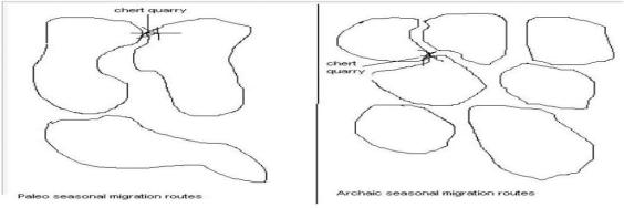
Figure 2:
Paleo and archaic migration circuits
Archaeologists
contend that this shift toward more diversified foraging corresponded with
somewhat spatially smaller and more regular annual migration circuits (Fagan
1991). People began developing regional identities and restricting their
migrations to smaller and more densely occupied territories (see Figure 2).
Sedentism had not yet emerged, but the transition from larger circuits to
smaller circuits and more diversified foraging was already a move in the
direction of sedentism. We were already moving down the food chain in order to
accommodate a larger population.
The First Villagers
It
is commonly believed that all hunter-gatherers were nomadic and that sedentism
emerged with planting during the “neolithic revolution.” But this is wrong.
Sedentism emerged before the neolithic revolution among diversified foragers,
and sedentary foraging societies survived into recent modernity in certain
ecologically abundant locations such as California and the Pacific Northwest.
Some hunter-gatherers in prime environments figured out how to exploit less
vulnerable natural resources such as seeds, tubers, small game, and fish. They
were able to live in permanent villages without depleting the environment.
The term “mesolithic” usually refers to hunter-gatherers
who live in more or less permanent settlements -- more or less, because many
mesolithic diversified foragers lived in a winter village and then moved to
other locations during the summer for seasonal hunting or gathering. The
transition from nomadism to sedentism was a matter of seasonal camps becoming
occupied for longer and longer periods of time, and with some of the population
remaining while others went off to other locations during special seasons. The
earliest sedentary societies were of diversified foragers in locations in which
nature was bountiful enough to allow hunter-gatherers to feed themselves
without migrating. These first villagers continued to interact with
still-nomadic peoples in both trade and warfare. The most well known of these
is the Natufian culture of the Levant, villagers who harvested natural stands
of grain around 11,000 years ago.
In
many regions the largest villages had only about 250 people. In other regions
there were larger villages, and regions with different population densities
were often in systemic interaction with each other (Chase-Dunn and Mann 1998).
Settlement size hierarchies emerged when a village at a crucial location, often
the confluence of two streams, became the home place of important personages
and the location of larger ritual spaces such as sweat lodges. Sedentary
foragers developed long-distance trading networks, and the shift from nomadism
to sedentism can be understood as a transition from a system in which people
move to resources to one in which resources are moved to people.
The
purely spatial aspects of this transition are also interesting. As we have seen
above in the description of the emergence of smaller seasonal migration
circuits and regionally differentiated tool styles, nomadic systems went from
very large to smaller, and to very small with the emergence of sedentism. But the
settlement systems of sedentary peoples began again to get larger, because
trade networks emerged to link settlements and peoples that were distant from
one another (see Figure 3). These trade networks grew and grew, though they
also occasionally shrank, a repeating pattern that Chase-Dunn and Hall (1997)
have called “oscillation.” Eventually
the systemic interaction networks became global (Earth-wide) in extent, and it
is then that we call them globalization. But networks shrank with the coming of
sedentism, and then expanded again to become completely global with the arrival
of oceanic voyaging.
Figure 3: Spatial networks shrank and then expanded with the emergence of sedentism
Human ecologists and anthropologists often study settlement-subsistence (ecosettlement) systems to understand the connections between human social organization and the environment. Subtle differences in ecosettlement systems can also be useful for understanding the relationships between adjacent groups. In prehistoric Northern California the Wintu and Yana peoples were both sedentary foragers, but there were important differences in their settlement and subsistence patterns. The Wintu lived along large rivers on the Sacramento valley floor and made seasonal treks up into the foothills and mountains (see Figure 4), while the Yana had their villages on smaller waterways in the foothills and made Fall visits to the valley floor and summer visits to the mountains (see Figure 5). The Yana villages were smaller than those of the Wintu. The Yana relied more completely on deer hunting, whereas the Wintu greatly relied on fishing, especially the seasonal harvest of migrating salmon (Chase-Dunn and Mann 1998). Interactions between the Yana and the Wintu were often conflictive, but there is little evidence that the more populous Wintu were exploiting or dominating the Yana. This was a case of core/periphery differentiation, but not core/periphery hierarchy.
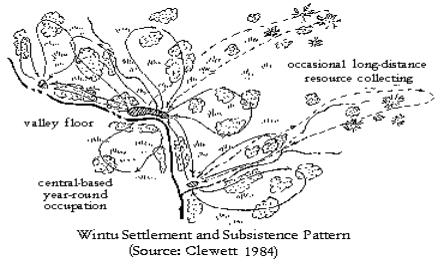
Figure 4:
Valley-dwelling Wintu settlement and subsistence (Clewett 1984)
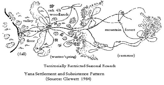
Figure 5:
Hill-dwelling Yana settlement and subsistence (Clewett 1984)
The spatial aspect of
population density is one of the most fundamental variables for understanding
the constraints and possibilities of human social organization. The “settlement
size distribution” – the relative population sizes of the settlements within a
region-- is an important and easily ascertained aspect of all sedentary social
systems. And the functional differences among settlements are a basic feature
of the division of labor that links households and communities into larger
polities and interpolity systems. The emergence of social hierarchies is often
related to size hierarchies of settlements. And the building of monumental
architecture in large settlements has been closely associated with the
emergence of more hierarchical social structures – complex chiefdoms and early
states.
The
spatial relationships among settlements in a region and there relative sizes
can be seen from archaeological evidence, and so this is an empirically useful
pattern that allows us to compare preliterate systems with those for which we
have documentary evidence. Figure 6 below contains Hans Nissen’s drawings of
1-tiered, 2-tiered, 3-tiered and 4-tiered settlement size hierarchies.
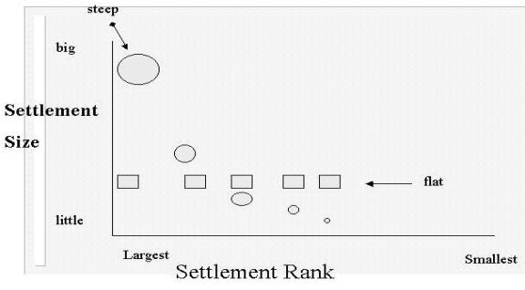
Settlement size distributions are often graphed to show
the relative population sizes of the settlements in a region. Figure 7 shows a
steep settlement size distribution in which the largest settlement is much
larger than the second largest, and a flat distribution in which all the
settlements are about the same size. Urban geographers suggest that a spatial
size hierarchy is related to the distribution of functions across settlements
and transportation costs (Christaller 1966). Goods and services that can easily
be distributed across a whole 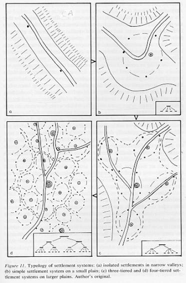 region from a central point will be located in the
largest central settlement, whereas products that cannot easily be stored or
transported will be produced locally in all the smaller settlements. The “range
of goods” creates the space economy. This approach was developed to describe
market societies, but it may also be relevant for understanding settlement
systems in which exchange is organized as reciprocity, because transportation
costs must be taken into account in the effort to be generous.
region from a central point will be located in the
largest central settlement, whereas products that cannot easily be stored or
transported will be produced locally in all the smaller settlements. The “range
of goods” creates the space economy. This approach was developed to describe
market societies, but it may also be relevant for understanding settlement
systems in which exchange is organized as reciprocity, because transportation
costs must be taken into account in the effort to be generous.
Urban geographers contend that there is a tendency for
settlement size hierarchies to approximate a rank-size or lognormal size
distribution. A rank-size distribution exists when the 2nd largest
settlement is ½ the size of the largest, the 3rd largest is 1/3 the
size of the largest, and etc. A lognormal distribution is similar in shape. It
exists when the ranked population sizes of settlements in a region fall on a
straight line
Figure 6:
Settlement size hierarchies (Nissen 1988:42)
when the population sizes
have been transformed to a logarithmic scale. “Urban primacy” is said to exist
when the largest city in a region is larger than would be expected based on the
rank-size or lognormal distributions. Empirical studies have shown that many
city size hierarchies do approximate the rank-size rule, but some are flat (as
with a 1-tiered size distribution) and many are primate (e.g. Chase-Dunn
1985b).
The original mesolithic invention
of relatively permanent village life was made possible by a diversified
foraging strategy that mixed the gathering of vegetable resources, fishing and
hunting of small game. This developed in a context in which the villagers
continued to cooperate and compete with more nomadic hunter-gatherers. The
Natufian culture of the Levant is the earliest known example of mesolithic
sedentism based on diversified foraging – this around 9000 BCE (Bar-Yosef and
Belfer-Cohen 1991; Moore 1982). Sedentary foragers probably invented fairly closely specified
territorial boundaries as
well as a more active intervention in the
productive cycles of nature. Sedentism also had a positive effect on population
growth. Families living in permanent villages could afford to have more closely
spaced children than nomadic peoples could manage (McNeill and McNeill 2003).
Both nomadic and sedentary foragers are known to have used fire to increase the
growth of food-producing plants and grazing areas attractive to game. This kind
of activity has been called “protoagriculture” (Bean and Lawton 1976).
Naturally
occurring stands of
Figure 7: Flat and steep settlement size distributions
grain were less productive in the smaller valleys in the
hills adjacent to the prime gathering regions of the Natufian peoples. It
is plausible that when the nomads in these neighboring regions tried to emulate
the sedentary life-style of the mesolithic villagers, they found that these
less abundant natural stands were quickly eaten up, and so they experimented with
planting the seeds that they had gathered in order to increase the productivity
of their lands. The proto-horticulture of the diversified foragers may have
morphed into true horticulture in the hands of the adjacent neighbors of the
original sedentary foragers (Hayden 1981). The first instance of semiperipheral
development may have been the emergence of a new productive technology
(planting) in a region adjacent to one in which an earlier new departure had
occurred (sedentism).[3]

Figure 8:
A 3-tiered settlement size hierarchy
The techniques of gardening
spread both west into the valley of the Nile and east toward Mesopotamia.
Gardening increased the number of people that could be supported by a given
area of land, making greater population density possible. Community sizes grew
in rain-watered regions and population growth led to the migration of farmers
away from the original heartland of gardening. Horticultural techniques
also diffused from group to group and were combined with the domestication of
pigs, sheep and goats. Domestication of animals and the use of milk as well as
meat eventually made it possible to move a few notches back up the food chain,
reversing some of the descent that followed the depletion of big game.[4]
Still-nomadic hunter-gatherers traded with the Neolithic towns, and new forms
of pastoral nomadism developed based on the herding of domesticated animals.
The simple model here is that
technological development (planting) increased population density and this facilitated
the emergence of larger settlements and social hierarchies. McNeill and McNeill
(2003) note that state formation in East Asia followed the spread of rice
cultivation (e.g. from China to Korea to Japan). They point out that a storable
and tradable grain is far more conducive to state formation than are crops that
are not easily stored (such as yams).
But there is evidence from the Chesapeake region of indigenous North
America that adoption of planting does not always immediately lead to greater
complexity and hierarchy (Chase-Dunn and Hall 1999).
The arrival of maize planting in
the Chesapeake region allowed the formerly mesolithic diversified foragers
living in rather large villages to redisperse into widely spread farmsteads,
and to reduce the intensity of their trading and ritual symbolization of group
identity and social hierarchy. So increasing productivity can, under some
conditions, lead to deconcentration and less social hierarchy. The ability
to produce a surplus does not automatically lead to hierarchy formation.
Surplus production must be possible, but hierarchy formation occurs when
population pressures lead to conflict. In the case of the Chesapeake, the
arrival of maize reduced population pressure and so those hierarchies and
larger villages that had already emerged went into decline. It was not until
population pressure had returned after a period of population growth that
villages and hierarchies grew again. New hierarchies emerge to regulate access
to scarce resources and to reduce the intensity of conflict (Chase-Dunn and
Hall 1997:Chapter 6).
As villages eventually grew
larger, trade networks did as well and craft specialists began producing for
export and importing raw materials. Trade networks expanded and
thickened, but not permanently. All networks exhibit a pattern of expansion and
contraction (oscillation), and these waves are punctuated by occasional upward
sweeps that connect much larger regions. Thus the waves of globalization and
deglobalization that have been shown to have occurred in the last 150 years
(Chase-Dunn, Kawano and Brewer 2000), are only the most recent and largest
instances of a much older pattern of network expansion and contraction.
To the Flood
Plain
Uruk, built on the floodplain
between the Tigris and Euphrates Rivers about 5000 years ago, was the first
large settlement that we call a city. Other cities soon emerged on the
floodplain and this first system of cities developed in a region that had
already seen hierarchical settlement systems of villages based on complex
chiefdoms. For seven centuries after the emergence of Uruk, the Mesopotamian
world-system was an interactive network of city-states competing with one
another for glory and for control of the complicated transportation routes that
linked the floodplain with the natural resources of adjacent regions.
According to Nissen (1988:Chapter
3) the first three-tiered settlement system in Southwest Asia emerged on the
Susiana Plain (in what is now Iran adjacent to the Mesopotamian flood plain) in
the Ubaid period (5500-4000 BCE). This would indicate the presence of
complex chiefdoms, and Wright (1986) points to the importance of the existence
of complex chiefdoms in a region as the necessary organizational prerequisite
for the emergence of pristine states.[5]
In other words, first states did not emerge directly from egalitarian
societies. Evidence from Uqair, Eridu and Ouelli shows that there were also
Ubaid sites on the Lower Mesopotamian flood plain that were as large as the
sites on the Susiana Plain at this time. The Early Ubaid phase at Tell Ouelli
shows remarkably complex architecture as early as anything on the Susiana
Plain. Thus there was an interregional interaction system of chiefdoms based on
a mix of rain-watered and small-scale irrigated agriculture.
In the next period (Uruk or
Late Chalcolithic from 4000-3100 BCE) the first true city (Uruk) grew up
on the floodplain of lower Mesopotamia, and other cities of similar large size
soon emerged in adjacent locations. Uruk had a peak population of about
50,000. Surrounding these unprecedentedly large cities were smaller towns
and villages that formed the first four-tiered settlement systems (Adams 1981).
This was the original birth of “civilization” understood as the combination of
irrigated agriculture, writing, cities and states. States also emerged somewhat later in the Uruk period on the
Susiana Plain (Wright 1998 and these also developed four-tiered settlement
systems (Flannery 1998:17). This was an instance of uneven development --
the transition from an inter-regional interchiefdom system to an
inter-city-state system that emerged first in Mesopotamia and then spread to
the adjacent Susiana plain.
Both cities and states got larger
with the development of social complexity, but they did not grow smoothly.
Rather there were cycles of growth and decline and sequences of uneven
development in all the regions of the world in which cities and states emerged.
It was the invention of new techniques of power and production that ultimately
made possible the more complex and hierarchical societies that emerged. The
processes of uneven development by which smaller and newer semiperipheral
settlements overcame and transformed larger and older ones has been a
fundamental aspect of social evolution since the invention of sedentary
life. And social evolution is analogous to ecological succession. Higher
levels of complexity cannot emerge directly out of low levels. Production of
surplus and the formation of chiefdoms must form the organizational soil out
our which state formation can grow. But states do not form automatically. They
are the products of human innovation in a situation in which they have been
made possible by earlier developments, and in which they can solve problems
that are posed under current conditions. Thus there is a degree of historical
contingency and agency in the process, and this is very evident in the pattern
of semiperipheral development, because it is not all semiperipheries that make
the leap.
Sedentary/Nomadic Coevolution
Sedentary
societies interacted with still-nomadic societies from the beginning of
sedentism, and archaeologists have studied farmer-forager interactions in many
contexts. This may have been the original core/periphery division of labor. We
have suggested above that it was nomadic neighbors of the sedentary Natufian
foragers who may have first developed planting when they sought to emulate the
village life of the Natufians. This may have been the earliest instance of
semiperipheral development.
As
sedentary societies expanded horticulture, they domesticated both plants and
animals, especially in ancient Southwest Asia and Egypt. Domesticated wheat and
barley hold there grains longer and are easier to harvest than the wild
varieties. Foragers had lived with dogs for millennia, but goats, sheep, pigs,
cattle, donkeys, horses and cattle were domesticated by either sedentary
peoples, or by nomadic peoples who became pastoralists in interaction with
sedentary farmers. Nomadism co-evolved with sedentism, a process most famously
described for East and Central Asia by Owen Lattimore (1940). And nomadic
pastoralists played an important role in the formation of sedentary states and
empires because they not only supplied meat and animal products, but they soon
underwent political evolution as well. The Central Asian steppe nomad
confederacies were able to mobilize large cavalries to attack agrarian empires,
and they both pillaged and extracted tribute in a process most clearly
described by Thomas Barfield (1989). It was also former nomadic pastoralists
who formed semiperipheral states on the edges of old core regions, and who were
the protagonists of empire formation when they conquered adjacent core states.
Thus did the dynamics of sedentary/nomadic relations play an important role in
the evolution of the tributary mode of accumulation.
What is the relationship between the
size of settlements and power in intergroup relations? Under what circumstances
does a society with greater population density have power over adjacent
societies with lower population density, and when might this relationship not
hold? Population density is often assumed to be a sensible proxy for
relative societal power. Indeed, Chase-Dunn and Hall employ high relative
population density as a major indicator of core status within a world-system
(Chase-Dunn and Hall 1997). But Chase-Dunn and Hall are careful to distinguish
between “core/periphery differentiation” and “core/periphery hierarchy.” Only
the latter constitutes actively employed intersocietal domination or
exploitation, and Chase-Dunn and Hall warn against inferring power directly
from differences in population density.
In
many world-systems military superiority is the key dimension of intersocietal
relations. Military superiority is generally a function of population density
and the proximity of a large and coordinated group of combatants to contested
regions. The winner of a confrontation is that group that can bring the larger
number of combatants together quickly. This general demographic basis of
military power is modified to some extent by military technology, including
transportation technologies. Factors such as better weapons, better training in
the arts of war, faster horses, better boats, greater solidarity among soldiers
and their leaders, as well as advantageous terrain, can alter the simple
correlation between population size and power.
Ironically,
George Modelski’s (2003) important study of the growth of world cities
completely ignores the growth of states and empires, though Modelski is himself
an astute scholar of international relations and geopolitical power. Modelski
contends that cities are the most important driving force of world system
evolution and that we may conveniently ignore states and empires. The
relationship between political power and settlements itself evolved over the
millennia, so that analysis of the relationship between size and power is
necessary in order to understand what happened.
The
most important general exception (in comparative evolutionary perspective) to
the size/power relationship is the phenomenon of semiperipheral development mentioned
above. The pattern of uneven development by which formerly more complex
societies lose their place to “less developed” societies takes several forms
depending on the institutional terrain on which intersocietal competition is
occurring. Less relatively dense semiperipheral marcher chiefdoms conquer
older core chiefdoms to create larger chiefly polities (Kirch 1984). Likewise,
semiperipheral marcher states, usually recently settled peripheral peoples on
the edge of an old region of core states, frequently are the agents of a new
core-wide empire based on conquest (Mann 1986; Turchin 2003).
Another exception is the phenomenon of semiperipheral capitalist city-states – states in the interstices between tributary empires that specialized in long-distance trade and commodity production. Though these were rarely the largest cities within the world-systems dominated by tributary empires, they played a transformational role in the expansion of production for exchange and commodification in the ancient and classical systems. And less dense semiperipheral Europe was the locus of a virile form of capitalism that condensed in a region that was home to a large number of unusually proximate semiperipheral capitalist city-states. This development, and the military technology that emerged in the competitive and capitalist European interstate system, made it possible for less dense Europe to erect a global hegemony over the more densely populated older core regions of Afroeurasia (Chase-Dunn and Hall 1997). The more recent hegemonic ascent of formerly semiperipheral national states such as England and the United States are further examples of the phenomenon of semiperipheral development.
The phenomenon of semiperipheral development does not totally undermine the proposition that societal power and demographic size are likely to be correlated. What it implies is that this correlation can be overcome by other factors, and that these processes are not entirely random. Denser core societies are regularly overcome or out-competed by less dense semiperipheral societies, but it does not follow that all semiperipheral or peripheral regions have such an advantage. On the contrary, in most world-systems most low-density societies are subjected to the power of more dense societies. Semiperipheral development is a rather important exception to this general rule.
Why should a city system have a steeper size distribution when there is a greater concentration of power? The simple answer is that large settlements, and especially large cities, require greater concentrations of resources to support their large populations. This is why population size has itself been suggested as an indicator of power (Taagepera, 1978a: 111). But these resources may be obtainable locally and the settlement size hierarchy may simply correspond to the distribution of ecologically determined resources. People cluster near oases in a desert environment. In such a case it is not the political or economic power of the central settlement over surrounding areas that produces a centralized settlement system, but rather the geographical distribution of necessary or desirable resources. In many systems, however, we have reason to believe that relations of power, domination and exploitation do affect the distribution of human populations in space. Many large cities are as large as they are because they are able to draw upon far-flung regions for food and raw materials. If a city is able to use political/military power or economic power to acquire resources from surrounding cities, it will be able to support a larger population than the dominated cities can, and this will produce a hierarchical city size distribution.
Of course the effect can also go the other way. Some cities can dominate others because they have larger populations, as discussed above. Great population size makes possible the assembly of large armies or navies, and this may be an important factor creating or reinforcing steep city size distributions.
The
relationship between power and settlement systems is contingent on technology
as well as political and economic institutions. Thus the relationship between
urban growth and decline sequences and the growth/decline sequences of empires
varies across different systems or in the same regional system over time as new
institutional developments emerge. We know that the development of new
techniques of power, as well the integration of larger and larger regions into
systems of interacting production and trade, facilitate the emergence of larger
and larger polities as well as larger and larger cities. Thus, there is a secular
trend at the global level and within regions between city sizes and polity
sizes over the past six millennia.
Studies
of the relationship between the rise and fall of empires and the growth/decline
phases of the largest cities in the same regions have found differences in the
temporal relationship between the growth and decline of largest cities and
largest empires. Partial correlations that take out the long-term trend show
that the medium-term relationship between city and empire growth is
significantly positive in Mesopotamia (2800 BCE-650 BCE), South Asia (1800
BCE-1500 CE) and Europe (430 BCE-1800 CE), but not in Egypt, West Asia, and
East Asia (Chase-Dunn, Alvarez and Pasciuti 2005: Table 5.2). In the regions in
which there are significant correlations this is sometimes due to the big
empires building their own big capital cities, but at other times a big city appears
in the region that is outside of the largest empire. This suggests that regions
go through general phases of expansion and contraction in which both cities and
empires grow and then decline, and this supposition is confirmed by the finding
in all regions of high partial correlations between the growth/ decline phases
of largest and second largest cities (Chase-Dunn, Alvarez and Pasciuti 2005:
Table 5.3), and rather surprisingly, a similar set of significant positive
partial correlations in all five regions studied between the growth/decline
phases of largest and second largest empires (Chase-Dunn, Alvarez and Pasciuti
2005: Table 5.4). This latter is surprising because territorial growth is a
zero sum game among adjacent empires, and yet the medium-term temporal
correlations are positive, indicating that empires get larger and smaller
together within regions. This is strong evidence that regions experience cycles
of growth and decline that affect both cities and states.
Synchronous East/West Growth-Decline
Phases
Earlier studies have used data on
both city sizes and the territorial sizes of empires to examine the hypothesis
that regions distant from one another experienced synchronous cycles of growth
and decline (e.g. Chase-Dunn and Willard 1993; Chase-Dunn, Manning and Hall
2000; Chase-Dunn and Manning 2002). Frederick Teggart’s (1939)
path-breaking world historical study of temporal correlations between events on
the edges of the Roman and Han Empires argued the thesis that incursions by Central
Asian steppe nomads were the key to East/West synchrony. An early study of
city-size distributions in Afroeurasia (Chase-Dunn and Willard 1993; see also
Chase-Dunn and Hall 1997: 222-223) found an apparent synchrony between changes
in city size distributions and the growth of largest cities in East Asia and
West Asia-Mediterranean over a period of 2000 years, from 500 BCE to 1500
CE. That led to and examination of data on the territorial sizes of
empires for similar East/West synchrony, which was found (Chase-Dunn, Manning
and Hall 1999). The empire size data also allow the examination rise and fall
sequences of large empires in South Asia, but these are not synchronous with
the growth/decline phases of empires in East Asia or West Asia (Chase-Dunn,
Manning and Hall 1999). Chase-Dunn and Manning (2002) have re-examined the city
size data using constant regions
rather than political-military networks to see if the East/West synchronous
city growth hypothesis holds when the units that are compared are somewhat
different. Their results confirm the existence of East/West city growth/decline
synchrony. From 500 BCE until 1500 CE, when the largest city in East Asia was
growing, the largest city in the West Asia/Mediterranean region was also
growing, and this also holds for empires (see Figure 9).
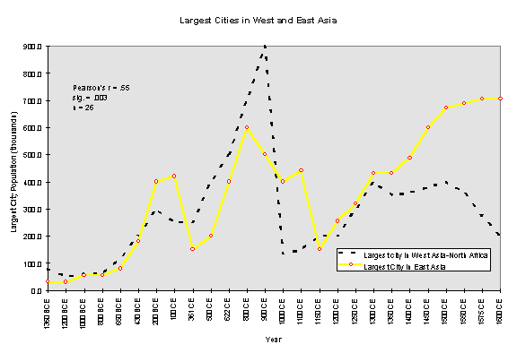
Figure 9:
Sizes of Largest cities in East Asia and West Asia/Mediterranean
Comparable other instances of
distant systems that came into weak contact with one another can be
found. Within the Old World, the Mesopotamian and Egyptian core regions
were interacting with one another by means of prestige goods exchange from
about 3000 BCE until their political-military networks (state systems) merged
in 1500 BCE. Chase-Dunn, Pasciuti, Alvarez and Hall (forthcoming) have already
examined this case for synchrony and have not found it, though the data on
Bronze Age city and empire sizes are very crude with regard to temporality and
accuracy. It is also possible to study the temporality of rise and fall and
oscillations among distant regions in the New World (e.g. Peregrine 2005).
The East/West growth/decline
synchrony seems to be rather robust, though better estimates and finer temporal
resolution of empire and city sizes might challenge it. Interregional synchrony
can be caused when two cyclical processes get simultaneously reset, either by
the same cause or by different causes. This could be a one-shot occurrence. Or
a process that is similarly cyclical can cause synchrony. Candidates for the
East/West synchrony are: climate change, epidemic diseases, trade
interruptions, or attacks by Central Asia steppe nomads. Sorting this out will
require data on these for the relevant regions over the relevant time period.
At present we have located time series data on climate change in China, and it
does not seem to be at all related to the East Asian rise and fall of empires.
If this is true, then logically climate change can be ruled out as a cause of
interregional empire synchrony.
Cities and
Social Evolution
George
Modelski’s World Cities, -3000 to 2000 examines human social evolution
over the past 5000 years by focusing on the growth of world’s largest cities
and also presents to results of a huge empirical effort to expand our knowledge
of the population sizes of the largest settlements since the Bronze Age. The
growth of cities is a useful indicator of world system evolution because the
ability of a society to produce and maintain a large settlement is a major
accomplishment. We can trace the emergence of social complexity by knowing
where the largest human settlements are at any point in time. Beginning with
Uruk, Modelski traces the emergence and spread of large cities from Mesopotamia
and Egypt to East Asia, South Asia, Europe and the Americas.
Regarding the city population data, Modelski has extended
and improved the work of that most eminent coder of city sizes, Tertius
Chandler (1987). For students of urban
and world history this work is of immeasurable value. Modelski has labored hard
to produce the best published comprehensive compilation of estimates of city
population sizes now available. His careful improvement upon earlier efforts to
estimate the population sizes of ancient cities is a huge step forward. He uses
estimates of the built-up area of a city and a population density factor
(Modelski 2003:11 and Note 5 on p. 17) to estimate the population sizes. He
adds considerable depth, especially to the coverage of the Bronze Age.[6]
In
the “ancient era” (-3000 to –1000) Modelski defines world cities as those that
reach a population size of 10,000 or more. In the following “classical era”
(-1000 to 1000) cities must be at least 100,000 in population size to count as
world cities. And in the modern era (since 1000) the cut-off point is one
million.[7]
Modelski observes a phenomenon, also noticed by Roland Fletcher (1995), that a
few cities are the first to reach a whole new scale, and then a size ceiling is
encountered during which cities in other regions catch up to the new scale. The
current maximum seems to be around twenty millions and the phenomenon of
catching up is now occurring. Some of the world’s largest cities are now in
developing countries such as Mexico, Brazil,
India and China.
Modelski’s study of the phases of urbanism is convincing regarding the contention that urbanization has been neither random nor linear. Instead it has followed a recurring pattern of rapid growth followed by slow growth or decline. A phase of fast growth concentrated in one or a few regions is followed by slower growth and the diffusion of large cities to other areas. Rapid and concentrated growth was followed by leveling off and dispersal due to “countervailing forces.” These countervailing forces emerged from what Modelski terms the “Center-Hinterland” divide of a regional world system. The first growth phase emerged in a center that eventually encountered limits to growth from resource exhaustion, environmental stress and “failures of knowledge.” The leveling process occurred as these limits were reached, weakening the old center. Incursions from the hinterland increased, taking advantage of the center’s weakness. This allowed the semi-hinterland, a region adjacent to the old center with smaller cities, to catch up to the urban scale of the old center.
Modelski
also compares his phases of urban growth with existing estimates of overall
population size and growth. He finds that the overall population growth phases
correspond in time with the urban expansions of the three eras. This study
leads to what Modelski calls a “manifest case of evolution.” The three phases
of urbanization correspond to periods of world system evolution: cultural,
social and political. The ancient cultural phase saw the creation of a learning
structure based on cities, writing and calendars, resulting in a platform for
sustained and intensified human interaction on a large scale. The classical
social phase brought about a more extensive, inclusive and integrated system.
Expanding during Karl Jasper’s “ Axial Age,” the cities of the classical period
can be grouped according to the world religions that dominated social
structures during that era. The modern
political phase poses choices regarding an evolutionarily stable structure of
world organization. Modelski predicts that the future fourth phase will be an
economic one that will see a “stabilization and consolidation of the economic
and material basis” of world society.
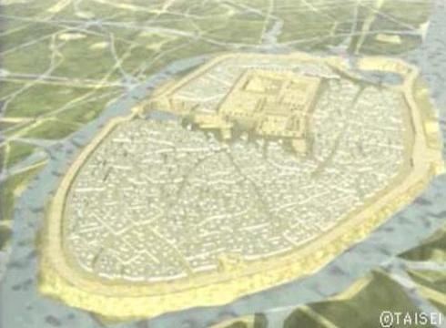
Figure 10: Sumerian Ur
From the point of view the structure of population
density both ancient and most modern industrial cities conform to the same
concentric volcano model. A central non-residential district (business or
monumental or both) is surrounded by concentric rings of decreasing density,
with low-density suburbs as the outer ring. This is the basic structure of
nearly all cities from the beginning in Mesopotamia 5000 years ago, to most
cities in the world today that were built before the advent of the automobile
(see Figure 11).
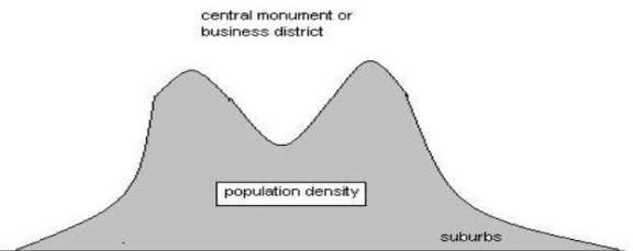
Figure 11: The volcano model of urban population density
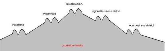
Figure 12: Low density postmodern city structure (Dear 2001).
There were earlier low-density cities, but they were rare. Angkor Wat, the gigantic capital of the Khmer state in Cambodia, was a city of farmlets with a large monumental center. Each residence had a tract of farmland for a yard, with canals linking a huge area. There were no high-density residential quarters. But this was an unusual exception to the volcano model. In the contemporary world older volcano cities are being surrounded and linked together by post-modern suburbs, so-called “edge cities” (Garreau 1991).

Figure 13: Suburban sprawl at Levittown
The problem of sustainable urbanization is crucial
for the human encounter with the consequences of our ballooning environmental
footprint. Over half of the human population of the Earth now lives in very
large cities, and these have spread rapidly over the land as population densities
within cities have decreased and cities have spread into huge city-regions. The
system of world cities has been flattening as megacities in the non-core
countries have caught up in terms of overall population size with the global
cities of the core.
Changes in the global city size distribution,
especially its flattening as megacities have emerged in the non-core, has
important implications for theories of urban growth, globalization and the
future of global inequalities. This
section considers the conceptualization of world cities and city-regions and
the idea of a global system of cities. I shall consider the global city-size
distribution and the implications of its flattening for the question of the
limits of settlement size and the problems of how to spatially bound cities and
city-regions. And I further discuss the emergence of low density and
multicentric cities.
The role of city systems in the reproduction and
transformation of human social institutions has been altered by the emergence
and predominance of capitalist accumulation. Whereas most of the important
cities of agrarian tributary states were centers of control and coordination
for the extraction of labor and resources from vast empires by means of
institutionalized coercion, the most important cities in the modern world have
increasingly supplemented the coordination of force with the manipulations of
money and the production of commodities. [8]
The long rise of capitalism was
promoted by semiperipheral capitalist city-states, usually maritime
coordinators of trade protected by naval power. The Italian city-states of
Venice and Genoa are perhaps the most famous of these, but the Phoenician
city-states of the Mediterranean exploited a similar interstitial niche within
a larger system dominated by tributary empires. The niche pioneered by
capitalist city-states expanded and became more predominant in the guise of
core capitalist nation-states in a series of transformations from Venice and
Genoa to the Dutch Republic (led by Amsterdam) and eventually the Pax
Britannica coordinated by the great world city of the nineteenth century,
London (Chase-Dunn and Willard 1994). Thus did capitalism move from the
semiperiphery to the core, constituting a world-system in which the logic of
profit making had become more important than the logic of tribute and taxation.
In 1900 CE London was still the largest city, but New York was coming up fast
(see Figure 14).
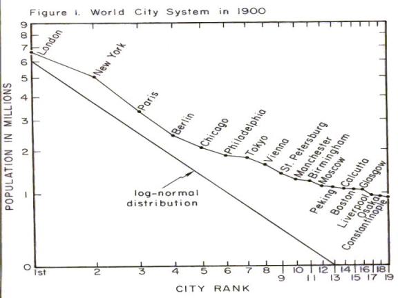
Figure 14: The world city size distribution in 1900 CE
Within London the political and financial functions
were spatially separated: empire in Westminster and money in the City. In the
twentieth century hegemony of the United States these global functions became
located in separate cities (Washington, DC and New York).
Thus the role of
cities in world-systems changed greatly as capitalism became the predominant
mode of accumulation over the last 500 years.
In earlier world-systems the biggest cities were empire-cities based on
the ability of states to extract resources using institutionalized coercion
(armies, bureaucracies, etc.) Capitalist cities existed, but they were in the
semiperipheral spaces between the large tributary empires. With the rise of
Europe we have capitalist cities becoming the most important cities in the
whole world-system. This is especially obvious with the rise of Amsterdam,
London and New York – the world cities of the capitalist era.
Nevertheless,
the relationship between power and size continued to operate (until recently)
in the modern system. Figure 15 displays changes in the city size distribution
of the largest cities in the European-centered world-system since 800 CE
(Chase-Dunn 1975). The city size distribution of interstate systems is almost
always flatter that the size distributions of settlements within a single
polity, because the multicentric political structure of interstate systems
affects the size distribution of settlements. Figure 15 uses the “Standardize
Primacy Index,” a measure of deviation from the lognormal rule (Walters 1975).
As can be seen, the Europe-centered city system is never steeper than the
lognormal distribution. And it is occasionally much flatter. The periods of
flatness mainly correspond with times of political decentralization in which
there was an absence of a hegemonic core power (Chase-Dunn and Willard 1994).
One possible
explanation for the recent descent into flatness of the world city size
distribution is the declining hegemony of the United States. But there are also
other possibilities, such as the 20 million-size ceiling posited by Fletcher
discussed below.
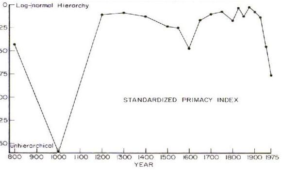
Figure 15: The city-size distribution of the
Europe-centered system, 800 to 1975 CE
The great wave of globalization in the second half
of the twentieth century has been heralded (and protested) by the public as
well as by social scientists as a new stage of global capitalism with allegedly
unique qualities based on new technologies of communication and information
processing. Some students of globalization claim that they do not need to know
anything about what happened before 1960 because so much has changed that the
past is entirely non-comparable with the present. Most of the burgeoning
literature on global cities and the world city system shares this breathless
presentism. All social systems have exhibited waves of spatial expansion and
intensification of large interaction networks followed by contractions. The
real question is which aspects of the most current wave are unique and which
are functional repetitions of earlier pulsations. The only way to sort this out
is to compare the present with the past.
World Cities
According to the
theorists of global capitalism it was during the 1960’s that the organization
of economic activity entered a new period expressed by the altered structure of
the world economy: the dismantling of industrial centers in the United States,
Europe and Japan; accelerated industrialization of several Third World nations;
and increased internationalization of the financial industry into a global
network of transactions (Sassen 1991). With the emerging spatial organization
of the new international division of labor, John Friedmann identified a set of
theses known as the “world city hypotheses” concerning the contradictory
relations between production in the era of global management and political determination
of territorial interests (Friedmann 1986).
Saskia Sassen
and others have further elaborated the “global city hypotheses.” Global cities
have acquired new functions beyond acting as centers of international trade and
banking. They have become: (1) concentrated control locations in the
world-economy that use advanced telecommunication facilities, (2) important
centers for finance and specialized producer service firms, (3) coordinators of
state power, (4) sites of innovative post-Fordist forms of industrialization
and production, and (5) markets for the products and innovations produced
(Sassen 2001a, 2000, 1991; Brenner 1998; Yeoh 1999; Hall 1996; Friedmann 1995).
These structural shifts in the functioning of cities have “impacted both the
international economic activity and urban form where major cities concentrate
control over vast resources, while financial and specialized service industries
have restructured the urban social and economic order” (Sassen 1991: 4). During
the 1990’s New York became specialized in equity trading, London in currency
trading, and Tokyo in size of bank deposits (Slater 2004).
Beaverstock, Smith and Taylor (1999) use Sassen’s focus on
producer services to classify 55 cities as alpha, beta and/or gamma world
cities based on the presence of accountancy, advertising, banking/finance
and law firms. [9]
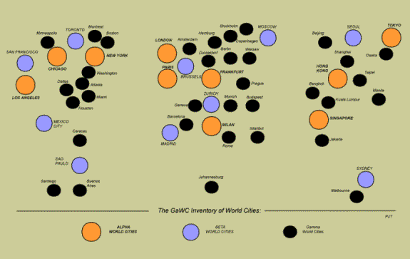
Figure 14:
Alpha, beta and gamma world cities according (Beaverstock, Smith and Taylor
1999)
The most important assertion in the global cities
literature is the idea that the global cities are cooperating with each other
more than the world cities did in earlier periods. The most relevant earlier
period is the Pax Britannica, especially the last decades of the
nineteenth century. If this hypothesis is correct the division of labor and
institutionalized cooperative linkages between contemporary New York, London
and Tokyo should be greater than were similar linkages between London, Paris,
Berlin and New York in the nineteenth century.[10]
Another important hypothesis of the global cities
literature is based on Saskia Sassen’s (1991) observations about class
polarization and the casualization of work within globalizing cities. The
research of Gareth Stedman Jones on Irish immigration into London’s East End in
the mid-nineteenth century (Jones 1971) shows that a somewhat similar process
of “peripheralization of the core” was occurring during the Pax Britannica.
Much of the
research on the global city system has been based on case studies of particular
cities that seek to identify the processes leading to their emergence and
positioning within the larger system (Baum 1997; Grosfoguel 1995; Todd 1995;
Machimura 1992; Kowarick and de Mello 1986). Janet Abu-Lughod (1999) traces the
developmental histories of New York City, Chicago, and Los Angeles through
their upward mobility in the world city system. While these U.S. metropoles
share similar characteristics with other world cities, they have substantial
differences in geography, original economic functions, transportation, and
political history to serve as fascinating cases for comparative analyses of
globalization.
Types of Suburbanization
From the ancient world until the
industrial age most cities had a monumental non-residential center surrounded
by high-density residential districts, the “volcano model” described above.
Walled cities enclosed these high-density residences, but when the cities grew,
suburban districts of rather lower densities formed outside of the old wall.
This concentric circle pattern continued to characterize cities in the
industrial age despite the geometric decline of transportation costs produced
by the steam-powered railways. It was
only when new cities were built during the automobile age that multicentric and
low-density cities such as Los Angeles emerged (Dear 2000; 2002). [11]
The low-density and multicentric pattern is added to old concentric-style
cities when they experience further growth during the automobile age –
so-called edge cities.
Thus it is important to
distinguish three main types of modern urban macrostructure:
v
Type A: concentric-radial cities organized around a central business
district with transportation corridors radiating out from it;
v
Type B: multicentric low density cities that are mainly “suburban” with
relatively small non-residential centers dispersed across the built-up
landscape (e.g. L.A.); and
v
Type C: a mixture of these two where the older concentric structure has
become edged by a newer multicentric and low-density region (so-called edge
cities).
City Regions
Another
phenomenon of recent urbanization is the emergence of city-regions, large areas
in which big cities are located rather closely to one-another and intervening
areas are mainly suburbanized. Urban geographers have noted that populations in
the rural areas and small towns of core countries are thinning and people are
concentrating in these city regions (Scott 2001; Simmonds and Hack 2000). The
city region phenomenon is made plain by examining Figure 17, a global map of
city lights at night produced from satellite images (see also Figure 18).

Figure 15:
World City Lights Show Urban Regions
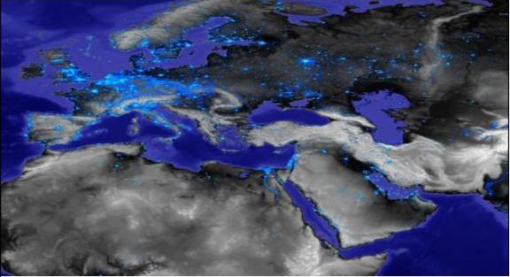
Figure 16: City Lights in Europe, North Africa and West Asia
All the continents have city regions, but the largest are the eastern
half of the United States and the western portion of Europe, with several other
regions also displaying this phenomenon. It is important to develop a method of
for spatially bounding multicentric city-regions that will enable us to
quantitatively compare these with one another in terms of spatial and
demographic sizes, population density, and settlement size distributions and to
study differences in their macrourban structures.
The Global City System
It is important to study changes in
the global city-size distribution because we are interested in the relationship
between cities and power, and because the apparent flattening of the global
city-size distribution discovered in the 1980s raises interesting questions
about the upper limits of the sizes of megacities. Why did the global city-size
distribution flatten out after 1950, modifying a pattern that had existed
throughout the British and U.S. hegemonies in which the most powerful country
had the largest city and there was a hierarchy of city population sizes
revealed by the world’s largest cities (Chase-Dunn 1985)? Roland Fletcher (personal communication) contends that
contemporary institutional and infrastructural inventions only allow for
megacities to function at maximum populations of around twenty millions and
this serves as a kind of ceiling effect which has allowed cities in the
non-core to catch up in terms of population size with the largest cities in the
most powerful states. This may be what has produced the flat global city-size
distribution that emerged after 1950. Another possibility that could account
for cities in the semiperiphery catching up with core cities is differences in
the demographic transition. Most core countries have achieved a replacement
fertility rate, but semiperipheral regions still have a higher fertility rate
and faster population growth. This could be a factor is allowing semiperipheral
cities to catch up to core cities as regards to population size.
 Fletcher’s notion of an upper limit on the sizes of large
contiguous cities might also be part of the explanation for the emergence of
city-regions rather than gigacities (the logical phase beyond megacities).
Another factor that could be at work in producing the size ceiling effect is
the emergence of a fairly strong environmental movement within the core. Figure
17 shows Abel Wolman’s plan for delivering water from the Columbia River to
Southern California. This
Fletcher’s notion of an upper limit on the sizes of large
contiguous cities might also be part of the explanation for the emergence of
city-regions rather than gigacities (the logical phase beyond megacities).
Another factor that could be at work in producing the size ceiling effect is
the emergence of a fairly strong environmental movement within the core. Figure
17 shows Abel Wolman’s plan for delivering water from the Columbia River to
Southern California. This
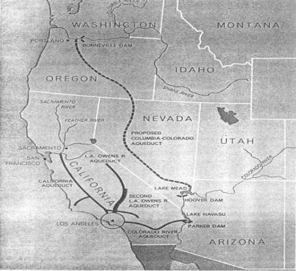
Figure 17: Abel Wolman's (1965) proposal for a canal from
the Columbia River to Southern California
scheme
was plausible from an engineering standpoint, but is arguably now impossible
for political reasons. Lack of cheap water will eventually become a limiting
factor on urban growth in Southern California if other factors do not stop it first.
Research on the contemporary global city-size
distribution and the phenomenon of city-regions needs to develop methods for
spatially bounding cities and city-regions that make use of satellite imagery.
Spatially bounding cities using census data has long been problematic because
information is often organized in terms of juridical boundaries that do not
conform to the real boundaries of cities as built-up areas.
Measurement of the
population sizes of cities must address the issue of spatial boundaries. How
can we know the number of people who reside in Los Angeles today? We use the
most recent census, a survey of
“residents” conducted by the U.S. federal government. What are the
spatial boundaries of “Los Angeles”? Do we mean the city of Los Angeles, Los
Angeles County, the contiguous built-up area that constitutes “greater Los
Angeles,” or a definition based on the proportion of the local population that
is employed in “Los Angeles”? Does “Los Angeles” include San Diego? Nighttime
satellite photos of city lights imply a single unbroken megalopolis from Santa
Barbara to Tijuana (see Figure 18). So
where is Los Angeles? We use the contiguous built-up area as our main
way of spatially defining cities. Urban geographers have made considerable
progress on the task of using satellite data to spatially bound cities.
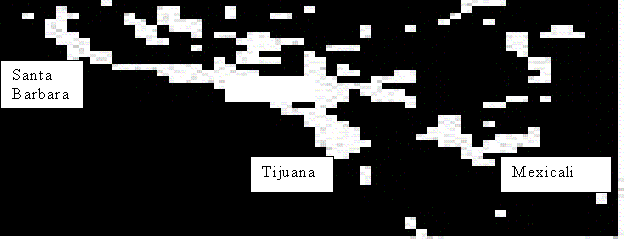
Figure 17:
Southern California/Northwestern Mexico conurbation (city lights)
The size and density of city-regions are related to global differences
in the level of development, and once these features of city regions are taken
into account it may turn out that the global city-region-size hierarchy is
related to economic and political/military power as it has been in the past.
Developing countries have succeeded in building very large megacities, but
their city-regions are not as large and dense as those in the core. Thus once
we get the unit of analysis right, city-regions rather than single urban
agglomerations, the older association between power and settlement size that
characterized the world city system for centuries may turn out to have survived
into the current era.
Figure 19 illustrates some of the problems just discussed. It
shows the population sizes of the world’s 29 largest cities in 2000 bounded by
municipalities rather than urban agglomerations or city regions. Because
municipal boundaries vary greatly across cases these numbers are greatly
affected by these differences. The apparent difference between Tokyo and New
York is a result of not including New Jersey and Long Island as part of greater
New York. Nevertheless, the flatness discussed above is apparent in the
distribution of sizes from New York on down the list.
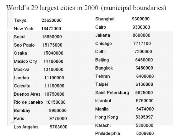
Figure 189:
World largest cities in 2000 CE (municipal boundaries)
Cities and the Future
About half
of the over six billion people on Earth now live in very large cities. Of
course, large cities are not all the same. Many of the large cities of the
non-core have huge slums where life is tenuous. Inequalities within and between
countries have increased during the most recent wave of globalization, just as
they did in the 19th century wave (O’Rourke and Williamson 2000).
The low-density suburban sprawl that has taken over the process of urban growth
in the core is immensely expensive in terms of resource use. And urbanization
has a huge direct effect on the environment, as cities absorb heat from the sun
and then release it, and humans use energy in cities, which contributes to
global warming. The
”urban heat island” is an important phenomenon that is contributing to global
environmental degradation (see Figure 20)
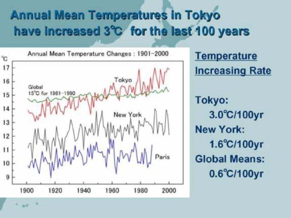
Figure 19:
Increasing temperatures in Tokyo, New York, Paris and the world
While core cities have deindustrialized, large cities in the semiperiphery have industrialized and are now the new sites of intense labor struggles (Silver 2003). The global “reserve army of labor” (rural people still not employed in the formal economy) is still large, but continued economic expansion and globalization will eventually incorporate everyone, and the long-run tendency for wages to rise will continue, eventually causing a crisis for capitalism (Wallerstein 2004).
Peter J. Taylor (2003) contends that globalization has decreased the importance of nation-states and increased the importance of cities, and that this may be a good thing because cities are more easily governable by communities of citizens.[12] Human settlement systems have been strongly involved in the processes of social evolution for thousands of years as both cybernetic nodes of innovation, and in the process of semiperipheral development. Regarding the latter, we can expect that new forms of governance relevant to solutions of the emergent problems of the twenty-first century will likely be invented and implemented in the cities of some of the semiperipheral countries, especially Brazil, India, Mexico and China. Curitiba, Brazil has already demonstrated a new form of sustainable urbanism that will become increasingly relevant as the natural resources that have been the basis of sprawl become depleted (Rabinowitz and Leitman 1996)). Democratic socialist regimes that come out of the new labor movements of the semiperiphery are likely to be important supporters of transnational social movements that will contest neoliberal (and neoconservative) global governance and push toward a new kind of globalization from below. The cities of the semiperiphery are fertile spaces for finding solutions for our increasingly urbanized planet.
References
Abu-Lughod,
Janet Lippman 1989 Before European Hegemony: The World System A.D.
1250-1350 New York:
Oxford University Press.
______________________
1999. New York, Chicago, Los Angeles: America’s Global Cities.
Adams,
Robert McCormick 1966 The Evolution of Urban Society. Chicago: Aldine.
Minneapolis,
Minnesota: University of Minnesota Press.
Arrighi,
Giovanni 1994 The Long Twentieth Century: Money, Power and the Origins of
Our Times. London:
Verso
Bairoch,
Paul 1988 Cities and Economic Development Chicago: University of Chicago
Press.
Barfield,
Thomas J. 1989. The Perilous Frontier: Nomadic Empires and China.
Cambridge,
MA: Basil Blackwell.
Bar-Josef,
Ofer and Anna Belfer-Cohen 1991 “From sedentary hunter-gatherers to territorial
farmers in
the
Levant.” Pp. 181-202 in Susan A. Gregg (ed.) Between Bands and States.
Carbondale, IL.:
Center for Archaeological Investigations,
Occasional Papers #9.
Baum,
Scott. 1997. “Sydney, Australia: a global city? Testing the social polarization
thesis.”Urban
Studies 34, 11: 1881-1901.
Bean,
Lowell John and Harry Lawton 1976 " Some explanations for the rise of
cultural complexity in
Native
California with comments on proto-agriculture and agriculture." Pp. 19-48
in Native Californians: A Theoretical Retrospective. L. J. Bean and
Thomas C. Blackburn (eds.) Socorro, NM: Ballena Press.
Beaverstock,
J.V., P.J. Taylor and R.G. Smith. 1999. “A roster of world cities.” Cities
16: 445-458.
Bentley,
Jerry H. 1993. Old
World Encounters: Cross-Cultural Contacts and Exchanges in Pre-Modern
Times. Oxford:
Oxford University Press.
Bergesen,
Albert and Ronald Schoenberg 1980 “Long waves of colonial expansion and
contraction
1415-1969” Pp. 231-278 in Albert Bergesen (ed.) Studies of the Modern
World-System. New York: Academic Press
Boserup,
Ester1981. Population and Technological Change. Chicago: University of
Chicago
Press.
Bosworth,
Andrew. 2000. “The Evolution of the World-City System, 3000 BCE to AD 2000.” In
World
System History: The Social Science of Long-Term Change, ed.
Robert A. Denmark, Jonathan
Friedman,
Barry K. Gills, and George Modelski. New York: Routledge.
Boulding,
Kenneth. 1978. “The city as an element in the international system.” In Systems
of Cities, ed.
L.S.
Bourne and J.W. Simmons. New York: Oxford University Press.
Brenner,
Neil. 1998. “Global Cities, Global States: Global City Formation and State
Territorial
Restructuring
in Contemporary Europe.” Review Of International Political Economy 5, 1:
1-37.
Braudel,
Fernand 1979 The Perspective of the World. New York: Harper and Row.
Carneiro,
Robert L. 1978 “Political expansion as an expression of the principle of
competitive
exclusion,” Pp. 205-223 in Ronald Cohen and Elman R. Service
(eds.) Origins
of the State: The Anthropology of Political Evolution. Philadelphia:
Institute for the Study of Human Issues.
________
2004 “The political unification of the world: whether, when and how – some
speculations.”
Cross-Cultural Research 38,2:162-177 (May).
Chandler,
Tertius 1987 Four Thousand Years of Urban Growth. Edwin Mellen Press:
Lewiston/Queenston,
Lampeter.
Chase-Dunn,
Christopher 1985a "The system of world cities: AD 800-1975" Pp.
269-292 in Michael
Timberlake
(ed.) Urbanization in the World Economy New York: Academic Press.
Chase-Dunn,
Christopher. 1985b. "The coming of urban primacy in Latin America," Comparative
Urban
Research XI, 1-2
Chase-Dunn,
Christopher 1992 "The role of cities in the transformation of
world-systems" Volker
Bornschier
and Peter Lengyel (eds.) World Society Studies, Volume 2. Frankfurt and
New York:
CampusVerlag.
Chase-Dunn, Christopher and Thomas D. Hall. 1997 Rise and Demise:Comparing
World-Systems Boulder, CO.: Westview
Chase-Dunn,
Christopher and Thomas D. Hall 1999 “The Chesapeake world-system: complexity,
hierarchy
and pulsations of long range interactions in prehistory.” Presented at the
annual meeting of the American Sociological Association
http://wsarch.ucr.edu/archive/papers/c-d&hall/asa99b/asa99b.htm
Chase-Dunn,
Christopher and Kelly M. Mann 1998 The Wintu and Their Neighbors. Tucson: University
of
Arizona Press.
Chase-Dunn, C. and E. Susan
Manning 2002 “City systems and world-systems: four
millennia
of city growth an decline.” Cross-Cultural Research 36,4:379-398.
Chase-Dunn,
Christopher, Yukio Kawano and Benjamin Brewer 2000 “Trade
globalization
since 1795: waves of integration in the world-system.”
American Sociological Review,
February.
Chase-Dunn, Christopher and Alice
Willard. 1993 “Systems of cities and world-systems,” IROWS
Working
Paper #5. https://irows.ucr.edu/papers/irows5/irows5.htm
Chase-Dunn, Christopher and Alice
Willard. 1994. “Cities in the central political-military network since
CE 1200.” Comparative
Civilizations Review 30: 104-32 (Spring).
Chase-Dunn, Christopher, Alexis
Alvarez, and Daniel Pasciuti 2005 "Power and
Size; urbanization and empire formation in world-systems" Pp. 92-112 in C. Chase-Dunn and E.N.
Anderson (eds.) The
Historical Evolution of World-Systems. New York: Palgrave.
Chase-Dunn, Christopher, Daniel
Pasciuti, Alexis Alvarez and Thomas D. Hall Forthcoming ““Waves of
Globalization
and Semiperipheral Development in the Ancient Mesopotamian and Egyptian
World-Systems”
in Barry Gills and William R. Thompson (eds.), Globalization and Global
History
London:
Routledge.
Christaller, Walter 196 Central
Places in Southern Germany. Englewood Cliffs, N.J.: Prentice-Hall
Christian, David 2004 Maps of
Time. Berkeley: University of California Press.
Clewett, S. Edward 1984 “Shasta
County prehistory: a proposed ecological/economic model,”
Presented
at the 18th annual meeting of the Society for California
Archaeology, Salina, March
29-31.
Collins, Randall 1999 Macrohistory:
Essays in the Sociology of the Long Run. Stanford, CA:
Stanford
University Press
Cronon, William 1991 Nature’s
Metropolis: Chicago and the Great West . New York: Norton.
Dear, Michael (ed.) 2001 From
Chicago to L.A.. Thousand Oaks, CA: Sage.
Denemark,
Robert, Jonathan Friedman, Barry K. Gills and George Modelski (eds.) 2000
World System History: the social
science of long-term change.
London:
Routledge.
Diamond,
Jared 1997 Guns, Germs and Steel: The
Fates of Human Societies. New York: Norton _____________2004 Collapse.
New York: Viking
Fagan,
Brian M. 1991 Ancient North America. New York: Thames and Hudson.
_____________
1999 Floods, Famines and Emperors: El Nino and the Fate of Civilizations.
New York:
Basic Books.
Fischer, David Hackett 1996 The
Great Wave: Price Revolutions and the Rhythm of History. New York:
Oxford University Press.
Flannery, Kent V. 1999 “The ground
plans of archaic states.” Pp. 15-57 in G. Feinman and J. Marcus
(eds.)
Archaic States. Santa Fe, NM: School of American Research
Fletcher,
Roland 1995 The Limits of Settlement Growth: A Theoretical Outline.
Cambridge: Cambridge
University
Press.
Frank, Andre Gunder and Barry K.
Gills (eds.) 1993 The World System: Five Hundred
Years or
Five Thousand ? London: Routledge.
Review
15:3(Sum):335-72.
Friedman,
Jonathan and Michael Rowlands 1977 "Toward an epigenetic model of the
evolution
of 'civilization.'" Pp. 201-78 in J. Friedman and M. Rowlands (eds.)
The
Evolution of Social Systems. London:Duckworth.
Friedmann,
John. 1986. “The World City Hypothesis.” Development and Change 17, 1:
69-84.
Galloway, Patrick R. 1986
“Long-term fluctuations in climate and population in the
preindustrial
era.” Population and Development Review 12,1:1-24 (March).
Garreau,
Joel. 1991 Edge city : life on the
new frontier New York : Doubleday
Goldstone,
J. A. 1991. Revolution and rebellion in the Early Modern world. University of
California Press, Berkeley, CA.
Graber,
Robert Bates 2004 “Is a world state just a matter of time?: a
population-pressure
alternative.” Cross-Cultural Research 38,2:147-161 (may).
Grosfoguel,
Ramon. 1994. “World cities in the Caribbean: the rise of Miami and San Juan.” Review
17,
3:
351-381.
Hall,
Peter. 1998. “Globalization and the world of cities.” In Globalization and
the World of Large Cities,
ed. F-c Lo and Y-m Yeung. Tokyo: United Nations University Press.
Hassan,
Fekri A. 1981 Demographic Archaeology. New York: Academic Press.
Harris,
Marvin. 1977. Cannibals and Kings: The Origins of Cultures. New York:
Random House.
Hawley,
Amos 1971 Urban Society: an ecological approach. New York: Ronald Press
Hayden,
Brian 1981 “Research and development in the Stone Age: technological transition
among
hunter-gatherers.”
Current Anthropology 22,5:519-548.
Henige,
David P. 1970 Colonial Governors from the Fifteenth Century to the Present.
Madison, WI.:
University
of Wisconsin Press.
Jones,
Gareth Stedman. 1971 Outcaste London:
A Study in the Relationship Between Classes in
Victorian
Society. Oxford: Clarendon
Johnson, Allen W. and Timothy
Earle. 1987. The Evolution of Human Societies: From
Foraging
Group to Agrarian State. Stanford: Stanford University Press.
Khaldun,
Ibn 1981 The Muqaddimah. Princeton: Princeton University Press.
King,
Anthony D. King. 1990. Global Cities: Post-Imperialism and the
Internationalism of London.
London:
Routledge.
Kirch, Patrick V. 1984 The Evolution of Polynesian
Chiefdoms. Cambridge: Cambridge
University Press.
_________ 1991 “Chiefship and competitive involution: the
Marquesas Islands of Eastern
Polynesia”
Pp. 119-145 in Timothy Earle (ed.) Chiefdoms: Power, Economy and Ideology.
Cambridge:
Cambridge University Press.
Kowalewski, Stephen A. 1996 “Clout, corn, copper,
core-peripohery, culture area” Pp. 27-38 in Peter N. Peregrine and Gary M.
Feinman (eds.) Pre-Columbian World Systems. Monographs in World
Archaeology No. 26. Madison, WI:
Prehistory Press.
Lattimore, Owen. 1940. Inner
Asian Frontiers of China. New York: American
Geographical Society, republished 1951, 2nd
ed. Boston: Beacon Press.
Machimura, Takashi. 1992. “The
urban restructuring process in the 1980’s: transforming Tokyo into a
world city.” International Journal of
Urban and Regional Research 16, 1: 114-128.
Mann, Michael. 1986.
The sources of social power:
Volume I: A history of power
from
the
beginning to a.d. 1760.
Cambridge: Cambridge University
Press.
Meyer,
David. 1986. “The world system of cities: relations between international
financial metropolises
and South American cities.” Social
Forces 64: 553-81 (March).
McNeill,
J.R. and William McNeill 2003 The Human Web. New York: Norton
Modelski,
George 2003 World Cities: –3000 to 2000. Washington, DC: Faros 2000
Modelski, G., W. R. Thompson.
1996. Leading sectors and world powers: the co-evolution
of global politics and economics.
University of South Carolina Press, Columbia, SC.
Moore, Andrew M.T. 1982 “The first
farmers in the Levant.” Pp. 91-112 in Young, Smith and Mortenson,
The Hilly
Flanks.
Murphy,
Craig 1994 International Organization and
Industrial Change: Global Governance
since
1850. New York: Oxford.
Naroll,
Raul 1967 “Imperial cycles and world order,” Peace Research Society: Papers,
VII,
Chicago
Conference, 1967: 83-101.
Neitzel,
Jill E. (ed.) Great Towns and Regional Polities in the Prehistoric Americaqn
Southwest and
Southeast. Albuquerque:
University of New Mexico Press.
Nissen,
Hans J. 1988 The Early History of the Ancient Near East Chicago: University of Chicago Press
O’Rourke,
Kevin H and Jeffrey G. Williamson 1999 Globalization and History: The
Evolution
of
a 19th Century Atlantic Economy. Cambridge, MA.: MIT Press.
Pasciuti,
Daniel 2002 “A measurement error model for
estimating the population sizes of preindustrial
cities,” https://irows.ucr.edu/research/citemp/estcit/modpop/modcitpop.htm
Pasciuti, Daniel and Christopher Chase-Dunn 2002 “Estimating
the population sizes of
cities.” https://irows.ucr.edu/research/citemp/estcit/estcit.htm
Peregrine, Peter N. 2005 “Synchrony in the New World: An Example of Archaeoethnology”
Paper
presented at the annual meetings of the Society for Scientific Anthropology,
Santa Fe, NM. February 26.
Peregrine, Peter N., Melvin Ember and Carol R. Ember 2004
“Predicting the future state
of the world using archaeological
data: an exercise in archaeomancy.” Cross-
Cultural Research 38,2:
133-146 (may).
Polanyi, Karl. 1944. The Great
Transformation: The Political and Economic Origins of
Our Time. Boston:
Beacon Press.
_____. 1957. "Aristotle
Discovers the Economy." Pp. 64-96 in Trade and Market in the
Early
Empires, edited by Karl Polanyi, Conrad M. Arensberg, and Harry W.
Pearson.
Chicago: Regnery.
Rabinovitch, Jonas and Josef
Leitman 1996 “Urban Planning in Curitiba” Scientific American (March).
Robinson, William I. 2004 A
Theory of Global Capitalism. Baltimore: MD. Johns Hopkins
University
Press.
Redman, Charles L. 1999 Human
Impact on Ancient Environments. Tucson: University
of Arizona
Press.
Sassen,
Saskia. 1991. Global Cities. Princeton:
Princeton University Press.
Scott, Allen J. (ed.) 2001 Global City-Regions : trends, theory, policy New York : Oxford University
Press
Simmonds, Roger and Gary Hack. (eds.) 2000 Global city regions : their emerging forms London :
Spon.
Skinner,
G. William (ed.) 1977 The City in Late Imperial China Stanford: Stanford
University Press.
Silver,
Beverly 2003 Forces of Labor. Cambridge: Cambridge University Press.
Sklair, Leslie. 2001. The Transnational Capitalist Class.
Malden, MA: Blackwell Publishers.
Slater, Eric 2004 “The flickering
global city,” Journal of World-Systems Research 10,3: 591-608 (Fall)
Smith, David A. and Michael
Timberlake. 2001. “World City Networks and Hierarchies, 1977-1997: An
Empirical
Analysis of Global Air Travel Links.” American Behavioral Scientist 44,
10: 1656-1678.
Spufford,
P. 2002, Power and Profit: The Merchant in Medieval Europe. London & NY:
Thames
& Hudson.
Taagepera,
Rein 1978 "Size and duration of empires: growth-decline curves, 3000
to
600 BC" Social Science Research 7:180-196
________ 1997 “Expansion and
contraction patterns of large polities: context for
Russia.” International
Studies Quarterly 41,3: 475-504.
Taylor, Peter J. 1996 The Way
the Modern World Works: World Hegemony to World
Impasse
. New York: John Wiley.
_________ 2003 World City Network. London:
Routledge
Teggart, Frederick J. 1939. Rome
and China: A Study of Correlations in Historical
Events. Berkeley: University of California Press.
Tilly, Charles 1990 Coercion,
Capital and European States: AD 990-1990. Cambridge,
MA:
Blackwell.
Timberlake, Michael. 1985.
"The world-system perspective and urbanization." Pp. 3-24 in M.
Timberlake(ed. ) Urbanization
in the World-Economy. New York: Academic Press
________1985. Urbanization in the World-Economy. New York: Academic Press.
Tobler, Waldo and S. Wineburg 1971
“A Cappadocian Speculation” Nature 231, May 7.
Todd, Graham. 1995. “Going Global
in the semiperiphery: world cities as political projects, the case of
Toronto.”
In World Cities in a World System, ed. Paul L. Knox and Peter J.
Taylor.New York,
New York:
Cambridge University Press.
Turchin,
P. 2003. Historical dynamics: why states rise and fall. Princeton University
Press,
Princeton, NJ.
Turchin,
P., and T. D. Hall. 2003. Spatial synchrony among and within world-systems:
insights from theoretical ecology. Journal
of World Systems Research 9,1
http://csf.colorado.edu/jwsr/archive/vol9/number1/pdf/jwsr-v9n1-turchinhall.pdf
Thompson, William R. 1990
"Long waves, technological innovation and relative
decline."
International Organization 44:201-33.
Van der Pijl, Kees. 1984. The Making of an Atlantic Ruling Class. London:
Verso.
Van De Mieroop, Marc
1997The Ancient Mesopotamian City New York: Oxford University Press
Wallerstein, Immanuel. 1984.
“The three instances of hegemony in the history of the capitalist world-
economy.” Pp. 100-108 in Gerhard Lenski (ed.) Current
Issues and Research in
Macrosociology,
International Studies in Sociology and Social Anthropology,
Vol. 37.
Leiden: E.J. Brill.
________________ 2000
The Essential Wallerstein. New York: New Press.
________________ 2003 World-Systems
Analysis. Durham, N.C.: Duke University Press.
WaIters, Pamela B. 1985.
"Systems of cities and urban primacy: problems of
definition and measurement." Pp. 63-120 in TimberIake,
1985.
Wilkinson, David. 1987
"Central civilization" Comparative Civilizations Review 17:31-
59 (Fall).
_________ 1991 “Core, peripheries
and civilizations,” Pp. 113-166 in C. Chase-Dunn
and T.D. Hall (eds.) Core/Periphery
Relations in Precapitalist Worlds. Boulder, CO:
Westview Press
Wilkinson, David. 1992. “Cities,
civilizations and oikumenes: I.” Comparative Civilizations Review 27:
51-87
(Fall).
_________2004 “The power
configuration of the central world-system, 1500-700 BC”
Journal of World-Systems Research 10,3:
655-720.
Wolman, Abel 1965 “The metabolism
of cities.” Science
Wright, Henry T. 1986.
"The Evolution of Civilization." Pp. 323-365 in American
Archaeology, Past
and
Future: A Celebration of the Society for American Archaeology, 1935-1985, edited
by
David J.
Meltzer. Washington, D. C.: Smithsonian Institutional Press.
___________1998 “Uruk states in
Southwestern Iran.” Pp. 173-197 in Gary Feinman and Joyce
Marcus
(eds.) Archaic States. Santa Fe, NM: School of American Research.
Yeoh, Brenda. 1999.
“Global/Globalizing Cities.” Progress In Human Geography 23, 4: 607-616.
Young, T.Cuyler, Jr., Philip E. L.
Smith and Peder Mortensen (eds.) 1982 The Hilly Flanks and Beyond:
Essays in
the Prehistory of Southwestern Asia Presented to Robert J. Braidwood. Studies
in
Ancient
Oriental Civilization, Number 36. Chicago: Oriental Institute of the University
of Chicago